WP Anthropo flood integration
Phase III
Formerly work package (WP) 2 from Phase II.
This topic in phase III of the Floods WG is the historical role of human action in catchments and floodplains modifying flood frequencies, hydro-sedimentary and environmental processes (e.g. contamination). These processes in turn threaten communities and cultural heritage sites located in flood prone areas.
Key questions are how, when and where floodplains were heavily transformed worldwide by land-use, land reclamation, hydraulic management, industrialization, mining, etc. providing evidence for the Anthropocene?
The ongoing regional multi-archive pilot studies in mountain regions (e.g. European and New Zealand Alps, Central Pyrenees, Himalaya, Andes) will address these issues by using cutting-edge methods (e.g. ancient sedimentary DNA; machine learning).
Phase II
The overall goals of the FWG are to integrate and analyze existing paleoflood data at the regional and global scales and to promote and disseminate paleoflood science and data at different levels. To reach these overall goals, FWG has been structured in three Work Packages (WP).
Integrating and analyzing paleoflood data
Coordinators: Lothar Schulte, Spain; Manfred Mudelsee, Germany; Scott St George, USA; Juan Carlos Peña, Spain (in charge of the early-career researchers)
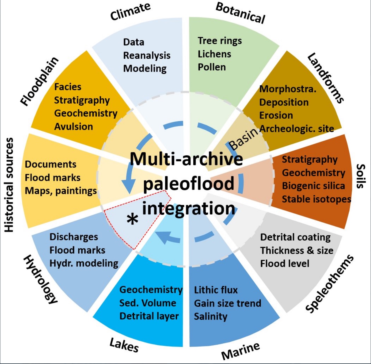
The integrated study of "real-world data" on past floods derived from historical and natural archives (field data) is challenging, but also provides an excellent opportunity to document the lowfrequency, large-magnitude flood events that occurred under different climate regimes (cooler, warmer and transitional climate periods) and/or environmental conditions (changes in land cover, land use, and river management).
Therefore, the long-term perspective of floods is fundamental for adequate hazard and risk assessment (e.g. flood-frequency analysis). However, the only way to reliably reconstruct robust paleoflood series while accounting for various sources of uncertainty is to analyze, compare, correlate and synthesize paleoflood data.
A further reason to use a variety of paleoflood data is to account for limitations in individual records. For example, ungauged catchments lack hydrological information while historical data may be sparse in remote areas with low population densities or that were recently settled, or in headwater catchments. Finally, a multi-archive approach provides the possibility to analyze the three-dimensional spatial distribution (horizontal and vertical) of flood records that best capture the physiographic and environmental diversity of a catchment.
Key points
The challenge for an accurate integration of paleoflood data relies on the following key points:
i) Dating uncertainties of the time series are important for statistical analysis of paleoflood data series;
ii) The problem of the comparability of heterogeneous catchments and landscapes, where hydrological and environmental settings are different. According to the controlling factors on processes, the system sensibility (e.g. erosion, aggradation) to climatological and hydrological extreme events is different;
iii) The correct interpretation of records that are directly involved in the physical process of flooding (e.g. sediments deposited directly by a river flood) and records that are indirect flood proxies recording climatic-environmental signals (sediments that are deposited by surface runoff in a small sub-catchment or tree rings);
iv) Due to the heterogeneous natural response of the subsystems to flood drivers, not all flood series can be integrated into a regional synthetic paleoflood master curve;
v) The criteria of selection or rejection of flood series must not only follow statistical protocols, but also consider process-based arguments. To identify "false alarms" and "missed" floods, data series should be tested by known regional hydrological extreme events that are documented by different records.
Objective
The objective of the statistical analysis of integrated paleoflood data is to infer the probability of floods across space (geography) and time (non-stationarity). The various sources of uncertainty (dating, measurement and proxy errors) must be fully accounted for in order to achieve a robust flood risk estimation with reliable error bars.
Dating uncertainties can be considered by modeling the age–depth curves of the sampled archive (e.g. a lake sediment core). Measurement errors are determined based on repeat measurements of a standard. Proxy errors can be quantified by calibrations on modern, correlated data pairs (proxy and indicated flood variable) if they are clearly identifiable. These uncertainties can be integrated using Monte Carlo simulations to generate error bars for the estimation. The risk estimate and error bars result from fitting a statistical model to the observed and simulated data.
The nonparametric Poisson model is suitable for analyzing the time dependence without parametric restrictions. Another parametric analysis option is extreme value distributions: the Generalized Extreme Value distribution for block extremes or the Generalized Pareto distribution for peaks-over-threshold data. Time-dependence can be formulated and estimated for each of the three parameters of the distributions.
A further idea is a hybrid statistical model: nonparametric for the occurrence and parametric for the size of an event. Besides estimation, it is also possible to formulate statistical tests of the hypothesis "time-constant occurrence rate". It is helpful to analyze the same data using different methodologies while simultaneously recognizing the strengths and weaknesses of each method (in terms of estimation standard errors, robustness with regard to assumptions and in terms of test power). Parametric spatio-temporal models can be used to study the other dimensions of the problem.
Changes in external forcing and atmospheric variability in the flood variability can also be explored by paleoclimate modeling to understand past climate related to flooding, and obtain rigorous comparisons between the output from numerical simulations e.g. from the Paleoclimate Modelling Intercomparison Project and regional paleo-flood data. Furthermore, these comparisons help to predict future climate change related to flooding.
Actions
i) Development of methodological approaches to integrate paleoflood datasets through regional pilot studies in different environments;
ii) Assessment of the contribution and improvements of flood frequency analysis using multi-archive analysis;
iii) Development of methodological and statistical approaches to analyze paleoclimate models in relation to the flood variability;
iv) Investigation of changes in external forcing and atmospheric variability of the flood periods by paleoclimate modeling.
Expected deliverables
i) Determination of regional flood-rich and flood-poor periods of the past;
ii) Geographic characterization and mapping of hydrological extreme events;
iii) Improvements to flood-frequency analysis;
iv) Exploration of past and future changes in forcing of floods.