Prehistoric land-cover and land-use history in Ireland at 6000 BP

Nicki J. Whitehouse1, M. J. Bunting2, M. McClatchie3, P. Barratt1, R. McLaughlin4, R. Schulting5 and A. Bogaard5
Land cover and use are compared for Neolithic Ireland, revealing complex inter-relationships between land cover and the archaeological record. Land-cover data can be misinterpreted when isolated from the land-use activities that help shape them, while land-cover data complements land-use datasets.
Land-use and land-cover changes have shaped our landscapes and ecological communities. We summarize land-use and land-cover changes for the period 6-4.2 ka BP (4000-2200 cal BCE; the Neolithic period for Ireland) as represented by cereal remains, pollen data, and limited zooarchaeological data (McClatchie et al. 2014, 2016; Whitehouse et al. 2014; McLaughlin et al. 2016). The earliest Neolithic in Ireland is dated to ca. 4000 cal BCE (~6 ka BP), but much of the demonstrably “Neolithic” archaeology dates from about 3750 cal BCE, when we see an abundance of rectangular houses and the first appearance of domesticated animals and plants. Neolithic archaeological material before 3750 cal BCE is limited – although not completely absent (McLaughlin et al. 2016; Schulting et al. 2017) – while the profusion of sites after this date indicates a radical transformation of human society and its associated cultural landscape.
The Neolithic is divided into:
Early Neolithic I (ENI) 4000-3750 cal BCE
Early Neolithic II (ENII) 3750-3600 cal BCE
Middle Neolithic I (MNI) 3600-3400 cal BCE
Middle Neolithic II (MNII) 3400-3000 cal BCE
Late Neolithic (LN) 3000-2500 cal BCE (Whitehouse et al. 2014).
Land use
 |
|
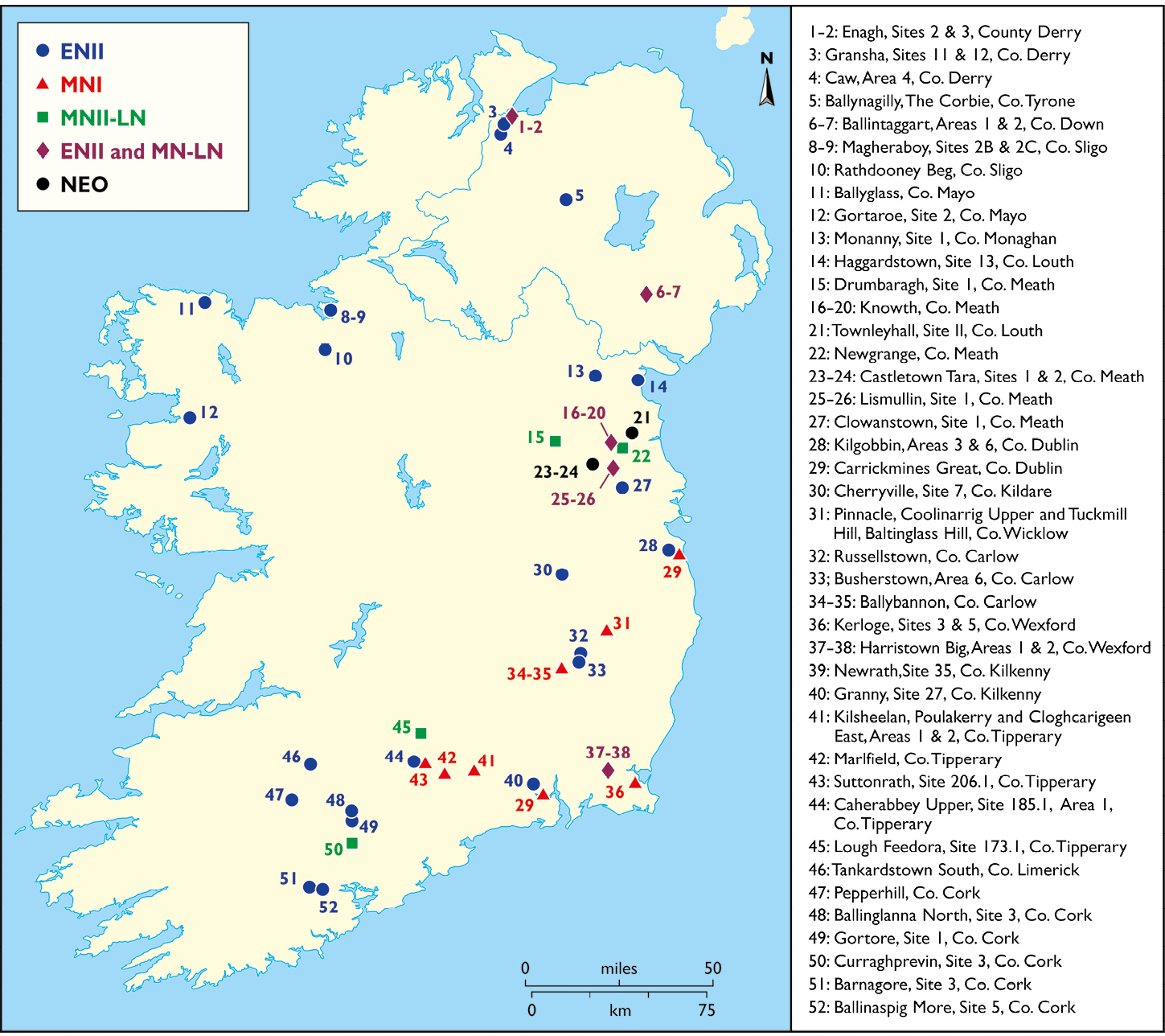
Figure 1: Distribution of archaeobotanical sites by time slice (note: some periods have been merged due to limited datasets. NEO: indeterminate Neolithic period). Sites follow Whitehouse et al. (2014). |
Archaeobotanical data derive from 52 sites (Fig. 1) assigned to the above time periods, using Bayesian site chronologies (McClatchie et al. 2014). Wheat and barley were being cultivated at many sites by 3750-3600 cal BCE (ENII), including emmer wheat (Triticum dicoccum Schübl.), possible einkorn wheat (Triticum monococcum L.), naked wheat (Triticum aestivum/durum/turgidum L.), naked barley (Hordeum vulgare L. var. nudum) and hulled barley (Hordeum vulgare L.). Flax (Linum usitatissimum L.) was also cultivated. Emmer wheat was the dominant cereal, most notably during the ENII and MNI periods. Cereals were present at only a small number of MNII–LN sites and included emmer wheat, naked wheat and indeterminate barley, with increased occurrences of the latter. From 3400 cal BCE (MNII), there is a reduction in archaeobotanical data and reduced human settlement evidence (McLaughlin et al. 2016).
Communities were also making use of locally available wild resources. Most assemblages contained a range of gathered foods, especially hazelnuts but also apple, bramble and sloe. Hazelnut shell fragments are present at 70-90% of sites, with decreasing levels in the MNII-LN. Fruit remains (e.g. crabapple, bramble) occur at a significant minority of sites, rising to 36% of MNII–LN sites. The regular occurrence of potential wild foodstuffs, as well as cereals, indicates a land use that included many different types of plant resources (McClatchie et al. 2014). Thus, areas devoted to cereal cultivation would have been present alongside the use and potential management of wild resources.
Management of agricultural plots was investigated by analyzing the ecological characteristics of potential arable weeds (Ellenberg et al. 1992; Bogaard 2002). Plants of disturbed places and annuals dominate the arable weeds, and likely indicate highly disturbed, permanently tilled cultivation plots and that people were not using shifting cultivation practices (McClatchie et al. 2014). This implies intensive management and investment of plots most akin to intensive garden cultivation and cultivation of plots under permanent agriculture.
EN II-MNI sites are distributed on the eastern and southern coastal regions of the island, along many of the river valleys, on prime agricultural soils (Whitehouse, unpublished data), with cultivation fields likely located close to settlements. Pockets of activity are present in the north and west; almost certainly vestiges of wider activities in these areas. There is little evidence for cultivation occurring in central areas of Ireland, today covered by extensive wetlands. During MNII-LN, sites are largely restricted to easterly areas; however, the paucity of evidence may be a reflection of taphonomic biases (McLaughlin et al. 2016).
Land cover
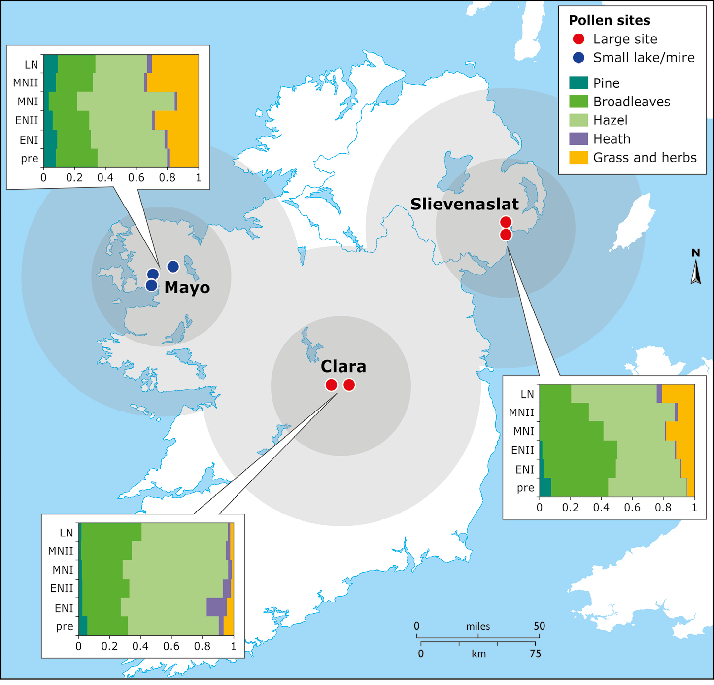
Pollen land-cover modeling was undertaken using the REVEALS model (Sugita 2007; Woodbridge et al., this issue). Pollen-count data were used covering the archaeological periods of interest; records originated from a single large site (lakes, bogs) or from a minimum of three smaller sites located close together (smaller lakes, mire sites). Age models for the selected sites were developed so we could group results into the relevant archaeological periods. Forest hollows were excluded because of their strong local pollen signal. The spatial scale of REVEALS reconstructions is ~100 x 100 km (Hellman et al. 2008; Trondman et al. 2016).
 |
|
Figure 2: REVEALS reconstructions of land cover for Neolithic Ireland in the six time slices (see text), with oldest at the bottom of the y-axis and most recent at the top. Values on the x-axis represent the proportions of the assigned land-cover type. Circles represent the approximate catchment represented by the REVEALS reconstructions. |
The reconstruction (Fig. 2) indicates woodland represents 80-90% of land cover, primarily consisting of broadleaf trees, with more pine represented in the west (County Mayo) than in the east. In the east, woodland cover represented ~80-95% of land cover over the Neolithic; on the west coast it declined from 80% to 70%, indicating more open areas than easterly locations. Central locations were almost 100% woodland cover; this actually increased during the Neolithic. This suggests Neolithic people did not generally infiltrate the central districts of the Midlands of Ireland at this time (Whitehouse et al. 2014; Fig. 1).
Hazel was an important component of woodland, making up ~40% of land cover. Although this shows an overall decline over the course of the Neolithic, hazel land cover increased by about ~10% in the east and west during MNI and MNII, before decreasing again to roughly similar levels. This represents either re-afforestation by hazel or increased hazel pollen production at this time. There is limited heathland and mire cover, despite its importance in the landscape today.
We see a general trend of increasing openness: ~5-30% of the landscape, likely reflecting some regional differences in land-use activities and settlement patterns and subtle differences in vegetation composition. There is, however, no marked clearance event, but rather a gradual process of opening of the landscape. In the west, open values were considerably higher than elsewhere. Early farmers may have taken advantage of already open habitats and increased areas of open land through pastoralism.
Integrating land use and land cover
Land-use data inform us about the archaeological activities at the local spatial scale, while estimated land-cover data provides an understanding at the regional spatial scale. Land cover in ENI and ENII indicates that between 10-20% of land was open in character, likely linked to land use from settlements, cereal cultivation, and animal grazing as well as some naturally open areas. While this is already in evidence during ENI, when open land-cover changes are modest, during ENII these effects became more pronounced, with clearance of an additional ~5-10% open land.
Land-cover modeling provides important insights into the re-afforestation phase in MNI (in the east) and MNII (in the west), consisting of increases in hazel wood coverage. Several possibilities could explain this: (i) a change in land use due to land abandonment and secondary succession by hazel into previously open areas (e.g. due to population decline), or people becoming more dispersed in the landscape or changing the location of their activities; (ii) increased hazel flower and pollen production due to coppicing for nut production, fencing and hurdle production (Waller et al. 2012) and (iii) post-recovery succession of hazel following burning of woodland to facilitate woodland grazing, as suggested for Neolithic Central Europe (Jacomet et al. 2016). This episode represents a change in land use that is likely associated with human behaviors. Possible climatic changes are unlikely to explain the increases seen in hazel pollen directly because of the uneven responses across the island, although climate may have indirectly driven aspects of land-use change (Whitehouse et al. 2014).
The combination of land-use and land-cover data allows a much fuller and meaningful interpretation of the datasets; both land-use and land-cover interpretations are enriched when combined.
acknowledgements
Aspects of this work were funded by the Heritage Council, Republic of Ireland INSTAR Research Programme for 'Cultivating Societies: Assessing the Evidence for Agriculture in Neolithic Ireland’ (Ref: 16682).
affiliations
1School of Geography, Earth and Environmental Sciences, Plymouth University, UK
2School of Environmental Sciences, University of Hull, UK
3School of Archaeology, University College Dublin, Ireland
4Archaeology/Palaeoecology, Queen’s University Belfast, UK
5Institute of Archaeology, University of Oxford, UK
contact
Nicki J. Whitehouse: nicola.whitehouse plymouth.ac.uk
references
Bogaard A (2002) Veg Hist Archaeobot 11: 155-168
Ellenberg H et al. (1992) Zeigerwerte von Pflanzen in Mitteleuropa. Scripta Geobot 18, 258 pp
Hellman S et al. (2008) Veg Hist Archaeobot 17: 445-459
Jacomet S et al. (2016) Holocene 26: 1858-1874
McClatchie M et al. (2014) J Arch Sci 51: 206-215
McClatchie M et al. (2016) Antiquity 350: 302-318
McLaughlin R et al. (2016) J World Preh 29: 117-153
Schulting R et al. (2017) Proc Preh Society 83: 305-323
Sugita S (2007) Holocene 17: 229-241
Trondman A-K et al. (2016) Veg Hist Archaeobot 25: 131-151