The AgriChange project: an integrated on-site approach to agricultural and land-use change during the Neolithic in Western Europe

Ferran Antolín, S. Häberle, A. Jesus, H. Martínez-Grau, G. Prats, M. Schäfer and B.L. Steiner
Early farmers were resilient thanks to a small-scale, household-based farming strategy that coped well with climate variability. The AgriChange project is compiling data on crops, local climate variability and risk-reducing strategies to reconstruct agricultural and land-use change in the Neolithic.
 |
|
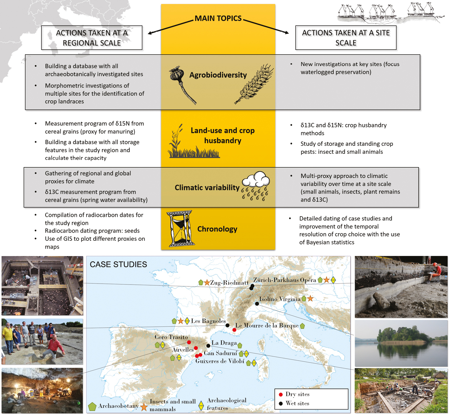
Figure 1: Scheme of the local-to-regional-scale analyses performed in the AgriChange project, and location of case studies. |
Research carried out during the last decades has brought to light a wealth of information on agriculture and wild-plant gathering in Western Europe during the Neolithic period, between 5700 and 2300 BCE (7.65-4.25 cal ka BP). As a result, broad-scale changes in crop types and agricultural practices have been outlined. These changes have the potential to provide insights on the factors that may have influenced agricultural decision making in the past, such as climate change, or land-use change related to technological developments (e.g. the introduction of the plough or new irrigation practices). So far, these aspects have not been assessed in an integrative way and at a large spatial scale. The latter is the main aim of the Swiss National Science Foundation AgriChange project (2018-2021). The geographic focus of the project is the Northwest Mediterranean region up to the Alpine Foreland (Fig. 1). This area witnessed contacts between different farming traditions (the central European one and the Mediterranean one) from the beginning of the Neolithic onwards and is therefore an ideal case study area. The project will thus contribute key data to LandCover6k for a first comprehensive detailed-scale reconstruction of land-use for the study area.
Decision making among smallholders is a complex issue that involves their global socio-economic and spiritual sphere. For this reason, a multi-proxy approach is pertinent. This includes proxies that allow the study of resource diversity over time in the past, spatial variability, exchange, and storage. In addition to this, proxies for paleoclimatic conditions at an adequate temporal resolution are necessary. Data from the northeast of the Iberian Peninsula serves as a useful example of potentials and pitfalls of the project’s approach.
The example of the Iberian Peninsula
 |
|
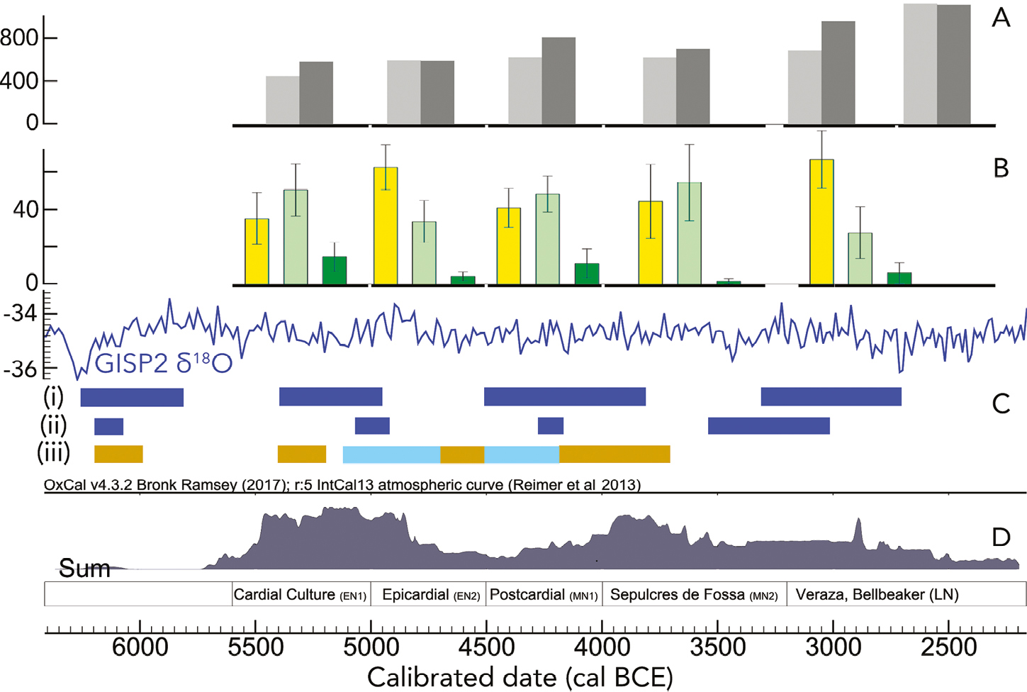
Figure 2: Multi-proxy analysis of agricultural changes during the Neolithic in the northeast of the Iberian Peninsula. (A) Storage capacity in liters: Median in light grey, mean in dark grey, temporal resolution marked below the graphs with a thicker black line (Prats 2017); (B) Mean percentage of each crop, sites grouped for time slices (Antolín 2016): Barley in yellow, naked wheat in pale green, glume wheats in dark green; (C) Paleoclimatic proxies: GISP2 δ18O (i) Minorca events (cold phases; Frigola et al. 2007); (ii) Alboran Sea cold events (Cacho et al. 2001); (iii) Sedimentary karst records (arid phases in brown, humid phases in light blue; Bergadà et al. 2017); (D) SRPD based on the dates from Morell B (PhD in progress, Autonomous University of Barcelona, Spain). |
The northeastern part of the Iberian Peninsula has seen the greatest advances in research during the last few decades and provides a detailed multi-proxy dataset that includes underground storage capacity, crop types, climate, and summed radiocarbon probability distributions (SRPD) as a proxy for population dynamics (Fig. 2 A-D, respectively). We can see there are two phases with a higher density of SRPD: 5.5-5.0 and 4.0-3.5 ka BCE. These coincide with arid phases and end with a cold and humid phase, respectively.
Naked (free-threshing) wheat tends to prevail during arid phases (5.4-5.2 and 4.2-3.7 ka BCE), while naked barley increased in the latter phase (4.0-3.5 ka BCE). The mean capacity of storage features increased in this phase, but not the median (therefore some larger storage pits were produced, probably as a response to uncertainty, while keeping the regular sizes in most cases). These changes might have enabled the social developments (population increase, higher settlement nucleation, social stratification and development of regular exchange networks of prestige objects) of the “Sepulcres de Fossa” period (equivalent to other Middle Neolithic cultures in Europe). In contrast, hulled wheats are poorly represented, being mostly found in the arid phases. In the last period (3.2-2.3 ka BCE), hulled barley seems to partly replace naked barley (not separated in Fig. 2), maybe due to higher aridity (hulled barley tolerates drought better than other cereals). During this period, storage features tend to become significantly larger, perhaps to help cope with risk and uncertainty and revealing a focus on increased yields over productivity per land area (i.e. extensification of agricultural land instead of continuing with more small-scale, intensively managed plots).
These results suggest that naked wheat might have been the preferred crop choice over other taxa except during wet phases, when naked barley perhaps was more successful. In response to a progressive climatic aridification during the youngest phases (3.2-2.3 ka BCE), hulled barley might have been a safe choice. This seems to be connected to a change in land use towards more extensive farming systems.
How will the AgriChange project lead us a step further?
Despite recent improvements in the datasets and the novelty of the multi-proxy approach, there are still some important limitations that need to be tackled. These include the restricted number of studied contexts, the poor chronological resolution of the observed agricultural changes, the existing limitations for the identification of the adoption of new landraces (beyond the main crop types), the scarcity of isotopic analyses that help to reconstruct land use changes (Fig. 1), and lack of knowledge on the short-term, local-scale climatic variability.
AgriChange will perform new research in a selected number of key sites and focuses on waterlogged deposits containing cultural layers (Fig. 1). Wetland sites can provide important insights for three reasons: (i) they offer precisely dated contexts, thanks to the preservation of wood remains datable to a calendar-year scale through dendrochronology, (ii) the cultural layers often present a stratification produced during short periods of time (20-40 years) that may reflect changes during the settlement occupation, and (iii) waterlogged deposits are generally characterized by good preservation conditions of plant and animal remains, which translates into more diverse environmental proxy data than those obtained in most dryland sites. The oldest lakeshore site of the Alpine area, Isolino di Varese (Varese, Italy) is one of the key sites studied in the project. It is a UNESCO World Heritage Site with an initial occupation dated to ca. 5.3 ka BCE with subsequent occupations in younger periods. AgriChange also includes dryland sites both for methodological and ecological reasons, since the distribution of sites with waterlogged deposits is quite restricted (often near lakes).
The project integrates several disciplines and multiple scales of analysis (Fig. 1). Archaeobotanical analyses form the basis of the interpretation and construction of the discourse, since they inform us about what was grown and where. Digital image analysis is used to identify crop types (see Ros et al. 2014; Bonhomme et al. 2017). Single seeds are individually radiocarbon dated (ca. 500 measurements) to identify crop changes over time in each region. AgriChange also uses carbon and nitrogen stable isotopes from cereal grains to infer land-use changes over time (extensive vs. intensive farming methods; Fraser et al. 2013). Carbon stable isotopes are also a valuable on-site proxy for crop water availability in spring (Araus et al. 2003; Fiorentino et al. 2008) and therefore might reveal short-term climatic changes, otherwise difficult to detect.
Additional proxies (storage features, insect and small animal remains) are investigated to reconstruct and understand crop storage practices and infer storage capacity and crop pests. Although underground storage pits are one of the most common archaeological features found in dry sites, and despite the fact that storage is recognized to be an essential aspect of farming societies (Sigaut 1988), inefficient recording methods and the lack of regional or supra-regional archaeological databases have not yet allowed the study of storage and productivity over time. Recording changes in storage capacity and identification of crop pests in the study area will bring important insights into food security and risk management in the past. Climatic variability is considered at a large spatial scale using global proxies, as well as local to regional scale by compiling several climate proxies such as plant macroremains, insect and small-animal remains and δ13C records from cereal remains.
AgriChange integrates multiple proxies to understand long-term agricultural decision making in the past, which will provide valuable lessons for current planning of resilient systems of smallholders in the face of today’s multiple challenges such as globalization, liberalization of agricultural land and climate change.
acknowledgements
The Swiss National Science Foundation funds the project “Small seeds for large purposes: an integrated approach to agricultural change and climate during the Neolithic in Western Europe” (grant number: PP00P1_170515).
affiliation
Integrated Prehistory and Archaeological Science (IPAS), Department of Environmental Science, University of Basel, Switzerland.
contact
Ferran Antolín: ferran.antolin unibas.ch
references
Araus JL et al. (2003) Crop Sci 43: 170-180
Bergadà MM et al. (2017) Quat Sci Rev 184: 26-46
Bonhomme V et al. (2017) J Arch Sci 86: 60-67
Bronk Ramsey C (2017) Radiocarbon 59: 1809-1833
Cacho I et al. (2001) Paleoceanography 16: 40e52
Fiorentino G et al. (2008) Palaeogeo Palaeoclim Palaeoecol 266: 51-58
Fraser R et al. (2013) World Archaeol 45: 492-517
Frigola J et al. (2007) Paleoceanography 22: PA2209
Reimer P et al. (2013) Radiocarbon 55: 1869-1887
Ros J et al. (2014) J Arch Sci 41: 568-575
Sigaut F (1988) Tools Tillage VI: 3-32