- Home
- Publications
- PAGES Magazine
- Finding The Magnitude of Human-induced Northern Hemisphere Land-cover Transformation Between 6 and 0.2 Ka BP
Finding the magnitude of human-induced Northern Hemisphere land-cover transformation between 6 and 0.2 ka BP
Dawson A, Cao X, Chaput M, Hopla E, Li F, Edwards M, Fyfe R, Gajewski K, Goring SJ, Herzschuh U, Mazier F, Sugita S, Williams JW, Xu Q & Gaillard M-J
Past Global Changes Magazine
26(1)
34-35
2018
Andria Dawson1, X. Cao2, M. Chaput3, E. Hopla4, F. Li5, M. Edwards4, R. Fyfe6, K. Gajewski3, S.J. Goring7, U. Herzschuh2,8, F. Mazier9, S. Sugita10, J.W. Williams11, Q. Xu12 and M.-J. Gaillard5
A spatially explicit pollen-based reconstruction of Northern Hemisphere land cover suggests open land increases of 10 to 100% across large parts of the study area over the period 6 and 0.2 ka BP. This change may have influenced past climate.
The quantification of feedbacks and forcings from the terrestrial biosphere onto past and future climate requires Earth system modeling studies that make use of well-constrained descriptions of past vegetation cover (henceforth land cover) and land-use change (Harrison et al.; Gaillard et al., this issue). Most efforts to map past vegetation on a continental to global scale are based on pollen percentages or pollen-based qualitative biome reconstructions. The growing availability of community-supported pollen-data repositories, improved radiometric dating precision, novel age-depth modeling approaches, pollen-vegetation model developments, and new statistical techniques have facilitated the development of highly resolved estimates of hemispheric-scale late Quaternary land-cover change. Spatially explicit regional land-cover reconstructions using pollen preserved in sedimentary archives can be achieved with mechanistic pollen-vegetation models, a kind of proxy system model that describes the processes governing pollen production, transport, and deposition from vegetation to sedimentary archives.
New generation vegetation reconstructions
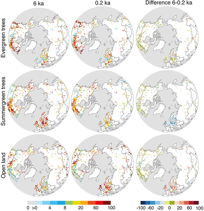
The PAGES LandCover6k working group (Gaillard et al., this issue) used established methods and comprehensive pollen and vegetation datasets to develop global Holocene (the last 11.5 millennia) reconstructions of land-use and land-cover change. More specifically, the working group focused on time periods commonly targeted by Earth system modelers (Harrison et al., this issue): e.g. 6 and 0.2 ka BP. Preliminary results for the Northern Hemisphere (NH) demonstrate the potential of pollen-based land-cover products in the assessment of anthropogenic land-cover change scenarios (e.g. KK: Kaplan et al. 2009; HYDE: Klein-Goldewijk et al. 2017), and for quantifying climate forcings due to past land-use change. Figure 1 shows the first hemispheric-scale land-cover reconstruction based on a mechanistic pollen-vegetation model; the model used here is known as REVEALS (Sugita 2007). These preliminary results precede and guide the publication of a more comprehensive description of methods and results.
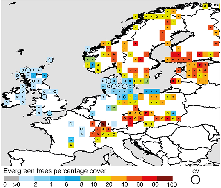
REVEALS can account for inter-taxonomic differences in productivity, dispersal, and deposition of pollen taxa in sedimentary basins (Sugita 2007) and estimates plant abundance on a regional spatial scale (2.5-10 103 km2) in percentage cover or m2/m2 using sedimentary pollen records. REVEALS also provides standard errors (SEs) of plant-cover estimates (Fig. 2). The reported SEs account for component errors within the relative pollen-productivity estimates (RPPs) of the represented pollen taxa and the variation among pollen records used in the reconstruction (Sugita 2007). REVEALS has been validated in several regions of Europe (e.g. Hellman et al. 2008) and North America (Sugita et al. 2010), i.e. pollen-based REVEALS estimates of plant cover based on modern pollen assemblages from surface lake deposits are comparable to plant cover inferred from satellite data, air photographs and vegetation inventories. The REVEALS approach is increasingly used to develop regional-scale land-cover reconstructions, but so far much of that effort has focused on Europe (e.g. Trondman et al. 2015). Land-cover estimates from REVEALS have also been compared to other methods. For example, Roberts et al. (2018) show that REVEALS-based past European land-cover reconstructions differ significantly from those of other pollen-based methods for large parts of the Holocene (Woodbridge et al., this issue). Kaplan et al. (2017) demonstrate that the KK scenarios of European Holocene deforestation are closer to REVEALS estimates of open-land cover than the HYDE scenarios version 3.1.
REVEALS requires several input variables that are not typically needed for other types of paleovegetation reconstructions, including lake or bog size, RPPs, and fall speed of pollen; this information may be missing in legacy data. LandCover6k has led an international effort to gather the relevant knowledge and data for this new generation of land-cover reconstructions. The methodological protocol used follows Mazier et al. (2012) and Trondman et al. (2015). Reconstructions are grid-based (1° x 1° which is the approximate spatial scale of REVEALS reconstructions) and use all appropriate lake- and bog-pollen records available within each grid cell. Pollen records are selected according to criteria including chronology quality, time resolution and pollen-count size. Pollen data was obtained from the European Pollen Database (EPD), Neotoma Paleoecological Database (http://neotomadb.org), and other pollen data archives. This synthesis uses multiple RPPs for a total of 45 plant taxa/pollen morphological types. These RPPs are compiled from Calcote (1995), Commerford et al. (2013) and Prentice and Webb (1986) for northern United States, Canada, and Alaska (23 taxa; Dawson et al. unpublished); Mazier et al. (2012; 25 taxa) for Europe; Cao et al. (unpublished; 27 taxa) for Siberia; and Li et al. (2017 and unpublished, 25 taxa) for China. The REVEALS estimates shown here (Fig. 1 and 2) are for the time periods 0.1-0.35 ka BP (0.2 ka, i.e. end of the Little Ice Age, high deforestation) and 5.7-6.2 ka BP (6 ka; low deforestation). The width (i.e. resolution) of the time windows follows Trondman et al. (2015) and ensures that pollen counts are large enough to obtain REVEALS estimates with low SEs. The obtained REVEALS estimates (and their SEs) for the individual plant taxa were grouped into three land-cover types: evergreen trees, summer-green trees, and open land§.
Land-cover transformation between 6 and 0.2 ka BP
This synthesis of NH land cover at 6 and 0.2 ka BP (Fig. 1) highlights stability (green color, +/-10%) or regional increases (red colors, >10%) in evergreen trees (ET) in Europe (Finland and Sweden), southern Siberia, western Cordillera, and northeastern regions of North America. However, ET decreased across portions of Siberia, subarctic Canada, and Scandinavia (blue colors, <-10%). Summer-green trees (ST) decreased (blue colors, <-10%) most significantly in Europe; they also occur in other regions of the NH (North America, Canada, Siberia, western China) where either open land or evergreen trees increased (green, with up to 10%, to red colors). Open land (OL) increases are evident and largest in Europe, and also occur in south-central and eastern Siberia, and northwest China. In North America, OL decreased in the eastern Great Plains, with less pronounced and localized OL increases in both western and eastern North America.
These patterns of OL increases reflect both extrinsic forcing by humans and climate and intrinsic forest processes. Further integration with paleoclimatic and archeological data is needed to disentangle these influences. Regardless of the cause, changes towards more open landscape may have affected both the global and regional climate. For example, climate modeling experiments using a regional climate model in Europe demonstrated biogeophysical forcings on climate from anthropogenic land-cover change between 6 and 0.2 ka BP of +/- 0.5-1.0°C, with the sign and size of the forcing varying by geographical location and season (Strandberg et al. 2014). Other experiments suggest that early anthropogenic land use in Mesoamerica (ca. Late Classic Maya Period, ca. 1.7-1.05 ka BP) may have decreased summer precipitation by 10 to 20% (Cook et al. 2012).
Improving dynamic vegetation models
The Landcover6k REVEALS syntheses will be of interest to many researchers, but they are primarily designed to support modeling studies of vegetation-atmosphere-anthropogenic feedbacks in the past. The REVEALS estimates will be compared to and integrated with the history-archaeology-based LandCover6k land-use mapping (Gaillard et al., Morrison et al., this issue). These syntheses will be used to evaluate and improve both land-cover and land-use descriptions that are implemented in Earth system modeling, in particular in the next phases of the PMIP (Paleoclimate Modelling Intercomparison Project; Harrison et al. and Stocker et al., this issue). Current work is focusing on the development of new methods that allow for reconstructions with more complete spatio-temporal coverage and which more explicitly account for uncertainty in the data (e.g. age-depth model uncertainty) and processes (e.g. dispersal and differential production) . This explicit treatment of uncertainty, combined with recent advances in data assimilation, allows for the integration of quantitative land-cover estimates and dynamic vegetation models to move towards improved ecological and climate forecasting.
§Evergreen trees: fir, spruce, pine, hemlock, juniper, other species of the cypress family; summer-green trees: larch, alder, birch, hornbeam, hazel, beech, ash, aspen/poplar, oak, linden, elm, chestnut (if growing as forest), willow; open land: heather, pink family, chestnut (if growing in cultural landscapes), walnut, amaranth/goosefoot family, ragweed, mugwort, other species of the daisy family, cabbage family, cannabis/hop, bindweed, sedges, legume family, meadow sweet and other species of Filipendula, mint family, lily family, grasses, knotweed family, ribwort plantain, hoary plantain, common plantain and other plantain species, buttercup family, rose family, common sorrel/sheep’s sorrel and other sorrel species, rye, and other cereals.
affiliations
1Department of General Education, Mount Royal University, Calgary, Canada
2Polar Terrestrial Environmental Systems, Alfred Wegener Institute for Polar and Marine Research in the Helmholtz Association, Potsdam, Germany
3Department of Geography, Environment and Geomatics, University of Ottawa, Canada
4Geography and Environment, University of Southampton, UK
5Department of Biology and Environmental Science, Linnaeus University, Kalmar, Sweden
6School of Geography, Earth and Environmental Sciences, Plymouth University, UK
7Department of Geography, University of Wisconsin, Madison, USA
8Institute of Earth and Environmental Sciences & Institute of Biochemistry and Biology, University Potsdam, Germany
9Department of Environmental Geography (GEODE), University of Toulouse II Jean Jaurès, France
10Institute of Ecology, University of Tallinn, Estonia
11Department of Geography and Center for Climatic Research, University of Wisconsin, Madison, USA
12College of Resources and Environment Science, Hebei Normal University, Shijiazhuang, China
contact
Andria Dawson: andria.dawson gmail.com
references
Calcote R (1995) J Ecol 83: 591-602
Commerford JL et al. (2013) Am J Plant Sciences 4: 34550
Cook BI et al. (2012) Geophys Res Lett 39: L16706
Hellman S et al. (2008) J Quat Sci 23: 21-42
Kaplan JO et al. (2009) Quat Sci Rev 28: 3016-3034
Kaplan JO et al. (2017) Land 6: 91
Klein Goldewijk K et al. (2017) Earth Syst Sci Data 9: 927-953
Li F et al. (2017) Veg Hist Archaeobot 26: 587-605
Mazier F et al. (2012) Rev Palaeobot Palyno 187: 38-49
Prentice IC, Webb T (1986) J Quat Sci 1: 35-43
Roberts N et al. (2018) Sci Rep 8: 716
Strandberg G et al. (2014) Clim Past 10: 661-680
Sugita S (2007) Holocene 17: 229-241


