Outreach and educational opportunities created by open-data resources
Amy Myrbo1, S. Loeffler1, A.L.C. Shinneman2 and R. McEwan3
Open-data-based geovisualizations including Flyover Country can engage students and the general public with science. Mobile technology allows data and visualizations to be brought into the field, facilitating discovery while users explore the natural world in real life.
Software tools that harness open-paleodata resources are opening new frontiers for education, public outreach, and citizen science. The ability to easily and seamlessly map and visualize disparate proxy datasets from multiple databases enables not only new research insights into past Earth system dynamics, but new opportunities for formal and informal education. The free, National Science Foundation (NSF)-funded Flyover Country mobile app (flyovercountry.io) takes such an approach; displaying the current location engages the user with place-based, on-demand access to real data and to ongoing scientific research. Bringing students and the general public science about the places they love – sometimes literally in their own backyard – supports place-based education (Semken 2005; Apple et al. 2014) and outreach, thereby acting as gateways for new audiences into science and scientific ways of thinking, as well as interaction with publicly funded scientific research. The ability to easily cache data to a mobile device means that users can take advantage of scientific data even while offline, outdoors, in remote settings. Here, we briefly summarize how the intersection of open scientific databases and mobile platforms is creating new opportunities for traditional classroom teaching, self-directed field trips by undergraduates or casual travelers, and citizen science.
Classroom-oriented resources increasingly use content from open, community-curated scientific data resources (CCDRs) as foundations for students to explore past global changes. For example, as of July 2018, SERC (the Science Education Resource Center at Carleton College, USA) hosted over 30 classroom activities using either the Neotoma Database (Williams et al. 2018) or the Paleobiology Database (PBDB; Uhen et al. 2013). The ability to overlay multiple datasets in a single visualization – floral and faunal records; ice-sheet and sea-level positions; tectonic plate paleolocations, etc. – is available directly in some CCDRs’ online resources (e.g. Neotoma Explorer, PBDB Navigator, GeoMapApp), so they are readily adapted to support classroom lessons.
 |
|
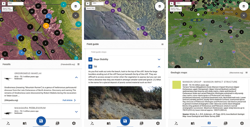
Figure 1: Examples of the Flyover Country mobile app interface. Left: Dots locating fossil localities from PBDB (teal and orange [currently selected]), Wikipedia articles (black), and continental sediment cores (blue), overlain on a satellite image and geologic map. Wikipedia articles on the dinosaur taxa found near the orange dot are shown below. Center: An instructor-submitted field-trip guide showing field trip stops (purple dots) and the user’s current location (blue dot with white outline). Field-trip content and photo are shown below. Right: Navigation mode changes the frame of reference to match direction of travel. Gray dots are fossil localities from Neotoma, black dots from Wikipedia. Geologic map unit information from Macrostrat is shown below. |
Mobile apps such as Flyover Country (Fig. 1) and Rockd (Schott 2017) extend this functionality to the outdoors. Students can use these apps to access data about a location while in the classroom or field, supporting place-based education (Semken et al. 2005; Apple et al. 2014), which uses the “hook” of a learner’s hometown or homeland to communicate the relevance and excitement of the sciences. Place-based education is an especially effective approach to engaging and entraining students into the geosciences, especially members of groups who strongly identify with places, such as many Indigenous people, recent immigrants, and members of rural communities. Whether the setting is a remote landscape or a concrete-covered city, geoscience plays a fundamental role (e.g. Sanderson 2009; Broad 2018): the location, layout, economy, population structure, human history, and amenities of a place are strongly influenced by the underlying geology, climate, ecology, and geomorphology.
 |
|
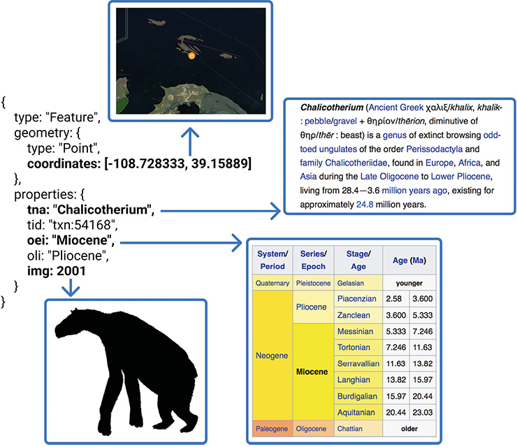
Figure 2: Flyover Country enriches sparse data by using text returned from PBDB to call to other data resources: in addition to plotting the coordinates of the fossil locality on the map, the taxon (Chalicotherium) and age (Miocene) are used to obtain the relevant Wikipedia articles, and the PhyloPic ID is used to obtain a silhouette of the extinct organism. |
Flyover Country fills a need for travelers, delivering interesting information about the landscape as seen out the airplane, train, or car window. The app calls data from Macrostrat (Peters et al. 2018), Neotoma, PBDB, Wikipedia, and OpenCoreData (opencoredata.org). Information in the app has global coverage, with data density dependent upon content in the databases. Flyover Country also links and enriches sparse datasets: for instance, taxon name and age for a fossil specimen returned from PBDB are used to call to other resources, including PhyloPic (phylopic.org) for a silhouette of the taxon reconstructed and Wikipedia for the articles about that taxon and geologic time period (Fig. 2). Because maps are readily understood by people of all languages and countries, Flyover Country is appealing to users worldwide. The app’s large userbase (240,000 downloads as of August 2018), reflecting a high level of interest from the general public in paleodata and related scientific information, promotes a virtuous cycle that encourages additional data resources to expose their data through Flyover Country. New data sources being added include datasets from IEDA databases (iedadata.org), state and federal geological surveys, additional paleobiological resources, tectonic plate reconstructions from GPlates (gplates.org), physiographic regions from Natural Earth Data (naturalearthdata.com), and articles from other languages’ Wikipedia databases.
Mobile tools like Flyover Country also create exciting new opportunities to enrich field experiences for undergraduates and the undergraduate geoscience curriculum. Field experiences at the introductory level have been shown to improve student satisfaction and likelihood to select and persist in the geosciences (Karabinos et al. 1992; Wilson 2018; Wolfe 2018). However, logistical challenges at institutions (Bursztyn et al. 2017), as well as work, family duties, and financial hardship particularly common to students from groups underrepresented in the geosciences (Bueno Watts et al. 2014) can restrict students’ ability to participate in class field trips. Faculty may provide alternative activities that are classroom- or homework-based, but these miss the opportunity to get students out into the field, making observations, developing questions, seeing real rocks and organisms, and connecting course content with the world they experience. Using mobile devices to present instructor-developed field-trip content and the user’s GPS location allows students to take independent field trips that fit their own schedules. Such an approach can engage students in ways similar to instructor-led trips, which could broaden participation in the field component of undergraduate courses, and thus help broaden participation in the geosciences overall.
Mobile apps can also access and help disseminate narrative- and location-based resources, such as field-trip guides from conference guidebooks and undergraduate courses. For example, a database of georeferenced field-trip guides sourced mainly from Geological Society of America guidebooks has been developed as part of Flyover Country and is available for use in any software tool. This database is open for new contributions at z.umn.edu/fcfg. Furthermore, these field trips are spatially discoverable, so users can find them without prior knowledge or possession of the guidebooks or course material.
Mobile apps can also be used to generate data, not just disseminate it, by encouraging citizen science (e.g. Bonney et al. 2014). For example, the Rockd app crowdsources images of outcrops that can ultimately be aggregated and used in scientific studies, and Flyover Country is connecting to NASA’s GLOBE Observer app to crowdsource ground-cover photographs to improve remote sensing information. As in well-established biodiversity and conservation-oriented citizen-science projects such as eBird (ebird.org) and iNaturalist (inaturalist.org), upload of new data to the project database can be facilitated through apps, and the user can see their data visualized on the map in the app in near-real time alongside data from both citizen scientists and professionals.
The future opportunities for development of education and outreach using open paleodata are equally exciting. App development is well within the capacity of small research/outreach teams with both scientific and software development skills; many materials supporting self-taught coding are available online (e.g. edx.org, which hosts courses from many institutions). Augmented reality offers new ways of overlaying data onto outcrops and landscapes viewed by the mobile device's camera (similar to star-map apps for the night sky, or the PeakFinder mobile app, peakfinder.org), further helping students and the public understand the geoscientific way of seeing. Similarly, inclusion of new high-quality narrative and visual content such as Esri Story Maps (storymaps.arcgis.com) and additional professional and crowdsourced field-trip guides bring decades of research to these new audiences. The developing field of semi-automated “text leveling” (e.g. newsela.com) when combined with geoscience semantics and ontologies, could help “translate” large volumes of content written for experts into material suitable for the general public. The availability of paleo and geoscience data in integrated travel systems (e.g. inflight entertainment, passenger trains and buses, self-driving cars) can bring the excitement of discovery, closely embedded in a sense of place, to new audiences worldwide.
acknowledgements
Flyover Country is supported by eight NSF awards, including 1338322, 1462297, 1541800, 1550913, and 1643277.
affiliations
1CSDCO/LacCore and Department of Earth Sciences, University of Minnesota, Minneapolis, USA
2Interdisciplinary Arts and Sciences, University of Washington – Bothell, USA
3Academic Health Center - Information Systems, University of Minnesota, Minneapolis, USA
contact
Amy Myrbo: amyrbo umn.edu (amyrbo[at]umn[dot]edu)
references
Apple J et al. (2014) J Geosci Edu 62: 1-4
Bonney R et al. (2014) Science 343: 1436-1437
Bursztyn N et al. (2017) GSA Today 27: 4-11
Broad WJ (2018) How the ice age shaped New York.” New York Times, accessed 22 August 2018
Karabinos P et al. (1992) J Geol Edu 40: 302-305
Peters SE et al. (2018) Geochem Geophys Geosys 19: 1393-1409
Sanderson E (2009) Mannahatta: A Natural History of New York City. Abrams, 352 pp
Schott R (2017) Bulletin 67: 1-4
Semken S (2005) J Geosci Edu 53: 149-157
Uhen MD et al. (2013) J Vert Paleontol 33: 13-28
Williams JW et al. (2018) Quat Res 89: 156–177
Wilson C (2018) Status of recent geoscience graduates 2017. American Geosciences Institute, 49 pp