An Inuit sea-ice-change atlas from Mittimatalik, Nunavut


Katherine Wilson1,2, A. Arreak1,3, Sikumiut Committee3 and T. Bell1,2
For the first time, Inuit have used their sea-ice knowledge to reconstruct historical sea-ice conditions to address climate change and resource development implications for safe sea-ice travel in their region.
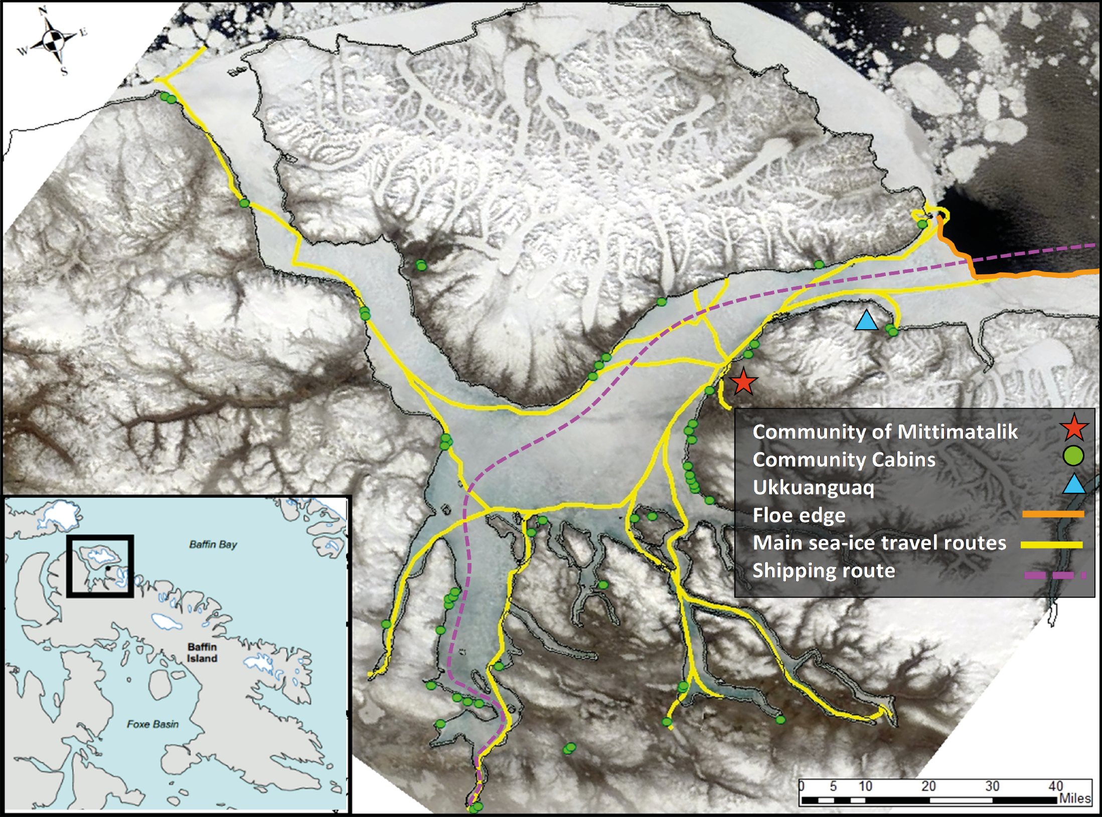
The Inuit community of Mittimatalik (Pond Inlet) is located in the Canadian High Arctic (Fig. 1). Traveling on the sea ice is central to the wellbeing, identity, and culture of the Mittimatalingmiut (residents of Mittimatalik). The nearby floe edge is a highly anticipated sea-ice feature that is present from late December to early July (Fig. 1). It provides a stable, landfast, sea-ice platform to hunt and fish near the open water. Although Inuit have always experienced and adapted to variable ice conditions, changes in ice conditions are now beyond what they would consider normal (Pearce et al. 2010). Therefore, Inuit are looking for additional information to support their safe travel decision-making. However, there is a gap in the availability of current sea-ice climate products. For example, outputs from sea-ice models are not at community scale, and sea-ice charts from national ice services capture the open-water summer shipping season, and not the Inuit sea-ice travel season (November to July in Mittimatalik) (Wilson et al. 2021). With a variety of near real-time and archived satellite imagery now publicly available, Inuit training, to interpret satellite imagery and create their own maps, is the missing step to support community-based sea-ice mapping (Laidler et al. 2011; Segal et al. 2020).
Mittimatalingmiut are already dealing with the impacts of climate change on sea-ice conditions, compounded by the pressure to increase commercial shipping in early July through the sea ice to the nearby Mary River iron-ore mine and port (Fig. 1). A local committee of Inuit sea-ice experts, called Sikumiut, identified the need to document the region's historical sea-ice conditions to understand: (1) where the sea ice was becoming more dangerous, to adapt their travel routes; and (2) the potential impacts of shipping earlier to the mine. Here we describe the process of co-creating a 23-year sea-ice-change atlas (siku asijjipallianinga) with Sikumiut, how the satellite imagery and geographic information system (GIS) mapping tools and training were put in the hands of Inuit with knowledge and experience of traveling on the ice, and how the atlas differs from other products to help address Inuit priorities.
What is Sea Ice Inuit Qaujimajatuqangit?
Inuit maintain the longest unrecorded climate history of sea ice in Canada. Mittimatalik's sea-ice climatology is preserved by orally passing down this knowledge and sharing their extensive and recent travel experiences on the sea ice (called Inuit Qaujimajatuqangit, or IQ). Sikumiut's deep climatological knowledge of the seasonal evolution of sea ice is what keeps them safe while traveling on it. However, their sea-ice IQ is not in a database, but exists in the collective minds of these expert sea-ice travelers. Also, their climatology is not focused on sea-ice extent, concentration, or volume in a general scientific sense, but more specifically on ice conditions for safe travel.
Making an IQ-based sea-ice change atlas
In 2019, a pilot curriculum was developed to train Andrew Arreak, an Inuit community researcher from Mittimatalik, in satellite imagery interpretation and GIS. In 2020, Arreak interpreted over 2000 Radarsat ScanSar Wide (1997 to 2019) and MODIS (2000 to 2019) images over six weeks (18 June to 29 July) to capture the evolution of spring ice-travel conditions prior to breakup. Arreak created weekly maps to digitize areas of sea ice that were no longer safe for travel, as the warmer temperatures began to melt the snow and sea ice. Arreak's sea-ice travel knowledge, and that shared with him by Sikumiut members, allowed him to monitor known areas in the satellite imagery for rapid change due to river outflow, melting glaciers, strong ocean currents, and recurring leads (cracks that stay open in the ice). Digitized maps were converted to raster to create maps to: (1) depict average ice travel conditions for each week of breakup based on the 23-year record, and (2) capture the spatial evolution of breakup for each year. Arreak was also trained in statistical analysis to review spatial and temporal trends in the sea-ice-breakup maps.
 |
|
Figure 1: Map of the Mittimatalik sea ice travel region, Nunavut, Canada. Background satellite image: MODIS True Color Composite, 9 June 2019 (NASA 2019). |
What the atlas tells us about sea-ice breakup
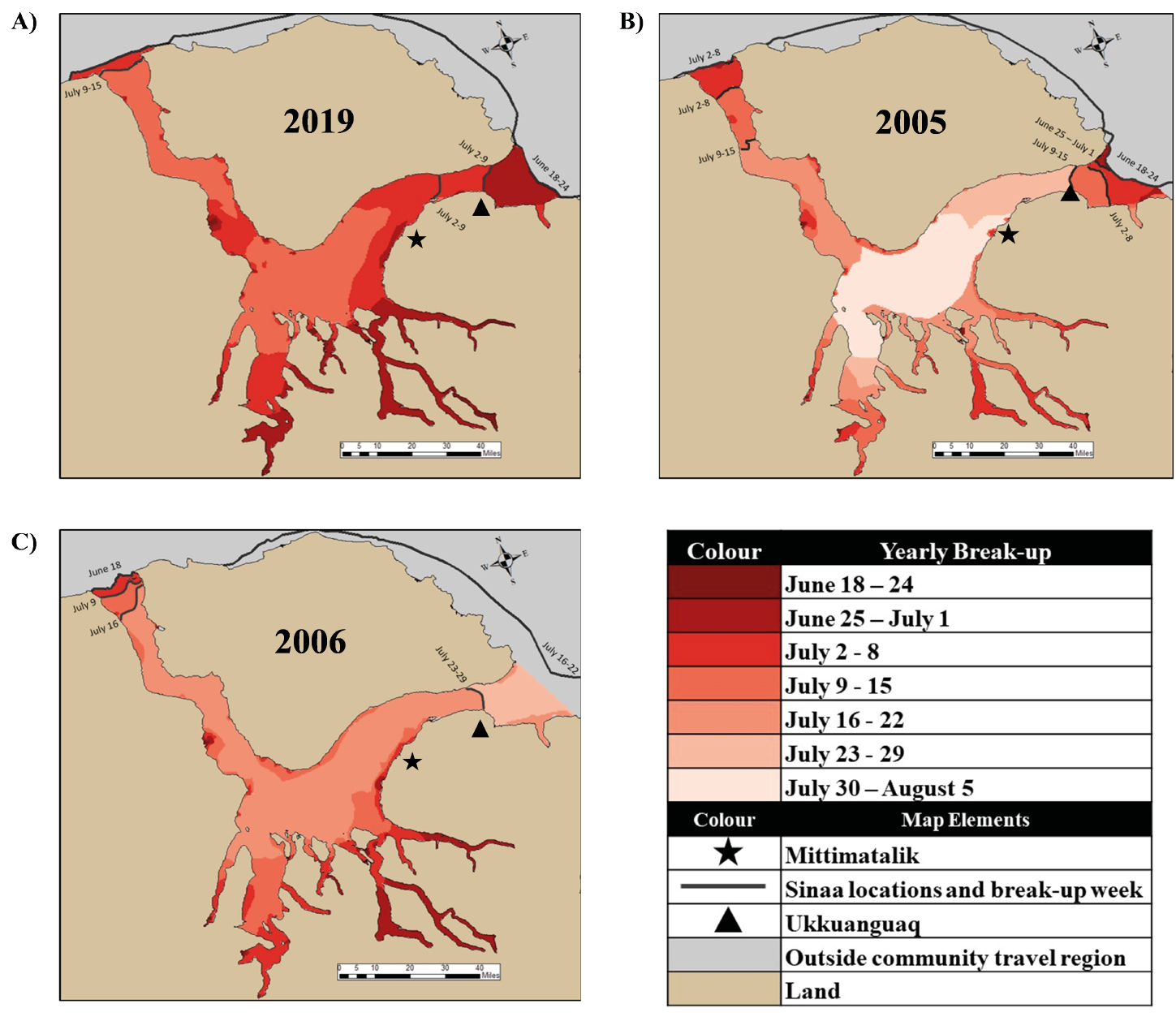
Snowmelt on the land signals the start of the breakup season. The average onset of snowmelt in the 23-year record was detectable in the satellite imagery the week of 11–17 June. By the following week of 18–24 June, areas of open water became visible in the satellite imagery in the southeast inlets and mouths of local rivers (Fig. 2). It is normal for the floe edge to fracture and break off to form new edges during the breakup season. Areas of breakup expand in the south and southeast sounds and inlets, and along the coastlines, until travel to the floe edge is no longer safe by the week of 9–15 July. The floe edge normally breaks up the week of 16–22 July. However, there was high variability in the timing of sea-ice breakup, and only the week of 2–8 July showed a trend towards earlier breakup with an R2 value of 0.34 (p value < 0.5).
Sikumiut has discussed that the floe edge is not as stable as it has been in the past. In reviewing the satellite imagery, the normal breakup date for the floe edge was 18 July (±2 days) between 1997 and 2019. Our results show a trend towards earlier breakup (R2 = 0.42, p < 0.05) with 7 July 2019 being the earliest breakup date in the record.
Implications for safe ice travel
In 17 out of 23 years (74%), the floe edge fractured to a location called Ukkuanguaq (Figs. 1, 2). Additionally, in 16 out of these 17 years, Ukkuanguaq is the last floe-edge location before the sea ice completely breaks up. Sikumiut already knew of the significance of the Ukkuanguaq; however, this mapped evidence supports community sea-ice adaptation needs. For example, talks are already underway to position time-lapse cameras and other monitoring equipment at this location to provide Mittimatalingmiut advance notice of breakup (Bell et al. 2020).
The average patterns for where and when the sea ice becomes dangerous for travel and the evolution of breakup were consistent with Sikumiut's IQ. However, Arreak explained that in some years the sea ice in front of the community can breakup earlier than at the floe edge (Fig. 2c). To continue to hunt and fish, Mittimatalingmiut will travel overland to access the sea ice just past Ukkuanguaq. The GIS-derived summary breakup maps did not capture this pattern, so we reviewed the individual yearly maps. This type of breakup pattern occurred about half of the time (48%), and there was no apparent increase in the frequency of this pattern over the last decade. Nevertheless, given the importance of hunting at the floe edge, there have been discussions within the community to build a road to Ukkuanguaq as an adaptation strategy to maintain their hunting and fishing activities at the floe edge.
 |
|
Figure 2: Yearly maps showing the spatial pattern of ice breakup in the Mittimatalik region. (A) The 2019 map shows the spatial pattern for an unusually early breakup. (B) The 2005 map illustrates the spatial pattern for an unusually late breakup. (C) The 2006 map provides an example of a year when the sea ice at the floe edge breaks last. |
The IQ-based sea-ice atlas also shows that extending the shipping season into the first two weeks of July could accelerate the breakup of the floe edge, shortening the sea-ice travel season further. If shipping is extended into the breakup season to support mining activities, Mittimatalingmiut now have a baseline of their local sea-ice conditions with which to compare and provide evidence for any future cumulative effects.
Conclusion
Siku asijjipallianinga differs from typical sea-ice climate atlases in that it used western tools to capture the collective IQ climatological sea-ice history of the region. Without Sikumiut's and Arreak's IQ and guidance, we would not have been able to interpret the satellite imagery or analyze its results from such an on-ice travel perspective. Because this atlas was created from an Inuit viewpoint, it provides an adaptation tool that Mittimatalingmiut can use to share locations of known and changing sea-ice conditions to plan for safe sea-ice travel. The atlas also clearly demonstrates the scientific merit of IQ in environmental assessments that can potentially impact the future sea-ice regime.
affiliations
1SmartICE Sea Ice Monitoring & Information Services Inc., St. John's, NL, Canada
2Department of Geography, Memorial University of Newfoundland, St. John's, NL, Canada
3Sikumiut Management Committee, Mittimatalik, Nunavut, Canada
contact
Katherine Wilson: katherine smartice.org
references
Bell T et al. (2020) Sikumiut perspectives on monitoring ice breakup near Mittimatalik: Summary workshops report. St. John's: Unpubl. Available at SmartICE Inc. with permission
Laidler GJ et al. (2011) Can Geogr 55: 91-107
NASA (2019) EOSDIS Worldview: worldview.earthdata.nasa.gov
Pearce T et al. (2010) Polar Rec 46: 157-177