Ice-core constraints on past sea-level change
Andrew J. Christ![]() 1, J.R. Andreasen
1, J.R. Andreasen![]() 2 and J. Toller
2 and J. Toller![]() 3
3
Ice-core records from Antarctica and Greenland reveal how ice sheets responded to past climate changes and contributed to sea-level rise. These archives are critical for understanding how ice sheets may respond and raise sea level due to climate change.
Anthropogenic climate warming threatens to melt portions of the Greenland Ice Sheet (GIS) and Antarctic Ice Sheet (AIS) and raise sea level 0.2–2.4 m by the end of this century (Fox-Kemper et al. 2021; McCrimmon et al. p. 112). During the Pleistocene (2.58 Myr BP–11.7 kyr BP), cyclical changes in Earth's orbit paced the expansion and retreat of Earth's ice sheets, with corresponding drops and rises in global sea level measuring hundreds of meters. These climate oscillations imprint onto Greenland and Antarctic ice cores, which inform ice-sheet contributions to past sea-level rise.
Here, we summarize how continuous and discontinuous ice-core records are used to understand past sea-level changes. Chronologically continuous records can be compared to regional and global paleoclimate datasets to resolve the interplay between ice sheets and sea level up to 800,000 years ago. Chronologically discontinuous records can directly determine past ice-sheet configurations and thus inform ice-sheet contributions to sea level at timescales spanning into the Pliocene (5.3–2.6 Myr BP) and possibly older.
Continuous ice-core records
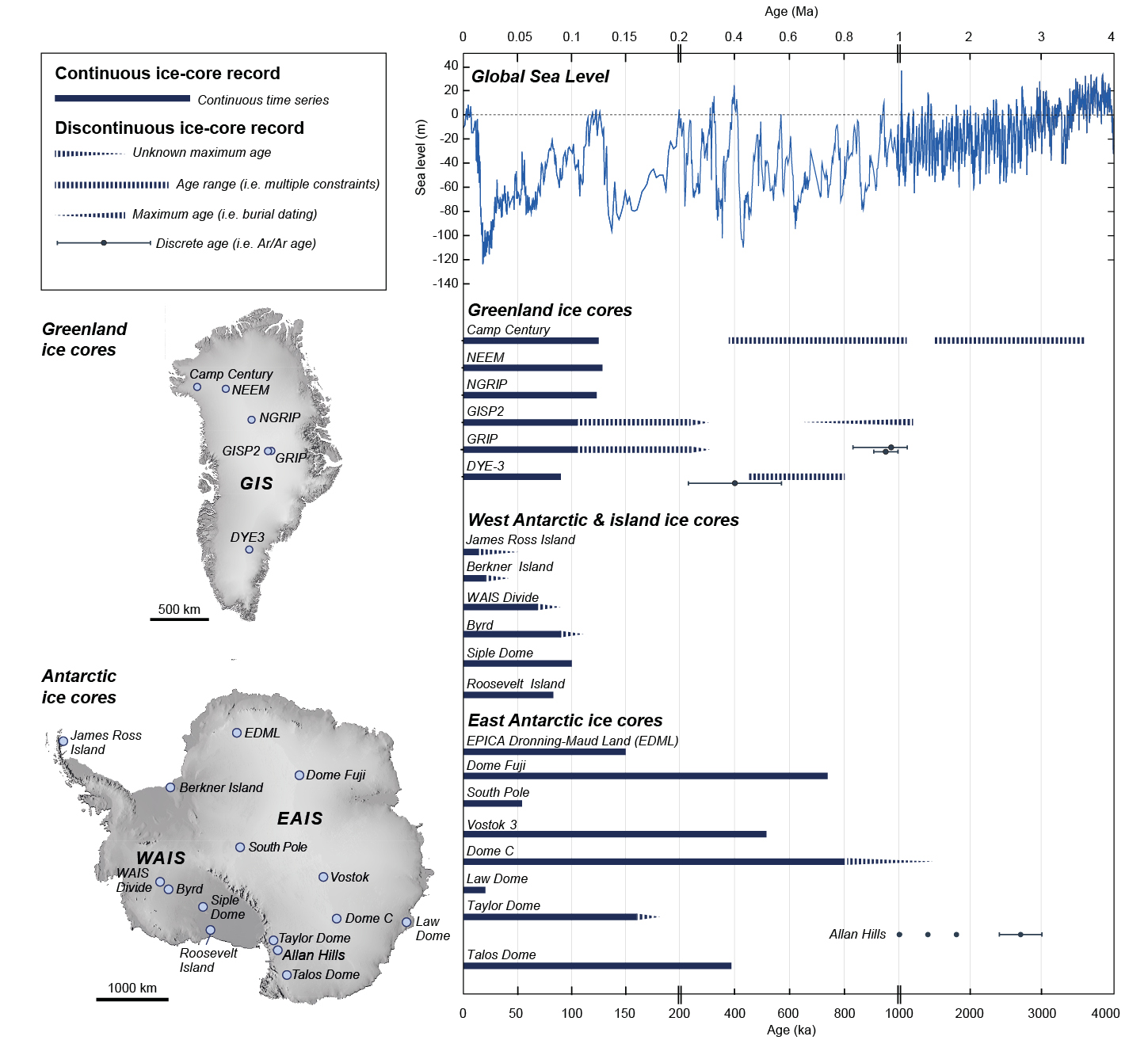
Ice cores with continuous records preserve paleoclimate data that is sustained through time. All continuous Greenland deep ice cores document Earth's climate through the Holocene (11.7 kyr BP–present) and the last glacial period (118–11.7 kyr BP), with some ice cores reaching into the last interglacial period (128-118 kyr BP; Seierstad et al. 2014; Fig. 1). In Antarctica, continuous ice cores capture much longer records that span multiple glacial–interglacial cycles up to 800 kyr BP (Wendt et al. p. 102) The time resolution of continuous ice cores can vary. For example, due to high snow accumulation rates, the West Antarctic Ice Sheet (WAIS) Divide Core (WDC; Fig. 1) contains annually resolved ice layers since 68 kyr BP (WAIS Divide Project Members 2013), while ice cores from the interior of East Antarctica, such as the European Project for Ice Coring in Antarctica (EPICA) Dome C, have lower resolution but reach 800 kyr BP and possibly as far back as 1.5 Myr BP (EPICA community members 2004; Parrenin et al. 2017).
Continuous ice cores can record changes in ice volume. Ice-core oxygen stable isotopic (δ18O) profiles document the elevation at which frozen precipitation fell onto the ice sheet. In Greenland, vastly different δ18O trends between ice cores near the ice margin (Camp Century and DYE-3) and those near the ice-sheet center (Greenland Ice Sheet Project (GRIP) and North Greenland Ice Core Project (NGRIP)) indicate significant elevation decrease along the ice-sheet periphery (Fig. 1), and thus ice-sheet thinning, during the last deglaciation (Vinther et al. 2009). In Antarctica, the oxygen isotopic profile of the WDC reveals temperature changes and subsequent ice advection and thinning (WAIS Divide Project Members 2013). Changes in ice-surface elevation from continuous ice cores can be compared against geologic records of ice-sheet thinning and retreat (Briner et al. 2020) to reconstruct changes in ice-sheet volume.
Temperature records extracted from continuous ice cores help to resolve the interplay between ice-sheet behavior and sea level during abrupt millennial-scale climate events. For example, during the last deglaciation from 14.7 to 13.0 kyr BP, Greenland ice cores record intense warming, while Antarctic ice cores show cooling due to hemispheric differences in ocean heat transport. These hemispheric differences in temperature demonstrate how the Antarctic and Greenland ice sheets respond to global warming in the context of the entire climate system.
Continuous ice-core records can also be compared against regional and global records of sea level deduced from coastal geomorphology, tectonic, and isostatic records, and isotopic analyses of marine sediments. The compilation of continuous ice-core records with far-field records of sea level captures both periods of rapid sea-level rise during deglaciation, as well as stability in sea level following the mid-Holocene (Lambeck et al. 2014). Over glacial–interglacial timescales, continuous ice-core records from Antarctica can be compared to the global ice volume reconstructed from benthic foraminifera in deep marine sediment.
 |
|
Figure 1: Continuous and discontinuous ice-core records from Greenland and Antarctica (locations shown in map insets) compared to a multi-proxy reconstruction of global sea level since 4 Myr BP (Miller et al. 2020) (note changes in timescale). |
Discontinuous ice-core records
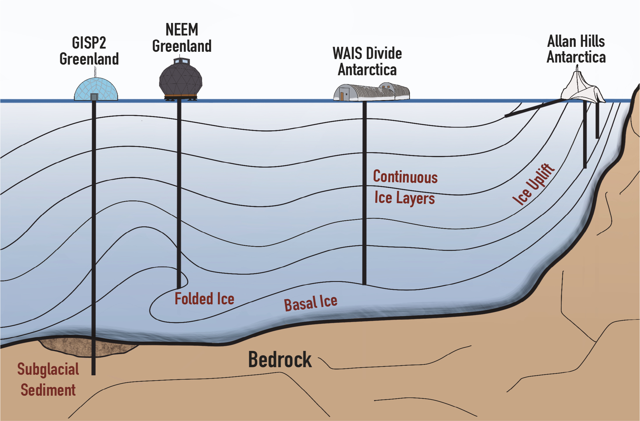
Discontinuous ice-core records, such as folded ice, uplifted ice, basal ice, subglacial materials, and ancient buried ice, offer snapshots of the past that can directly constrain ice-sheet configurations at timescales reaching into the Pliocene (5.3–2.6 Myr BP; Fig. 2). Ice-core records become discontinuous due to ice deformation, glacial erosion, or disconnection from the wider ice sheet. Ice flowing across its bed can fold, complicating simple stratigraphic interpretations of ice chronology. When the ice deformation history is disentangled, ice-core records can be tied to time periods older than the overlying ice. For example, the North Greenland Eemian Ice Drilling (NEEM) ice core from northeast Greenland contains folded ice from ~130 kyr BP during the warm Marine Isotope Stage 5e interglacial period, when sea level was 4–6 m higher than today (NEEM community members 2013). Older ice can be uplifted to the surface where ice flowing across the bed encounters mountainous topography, providing a snapshot of atmospheric composition older than continuous ice-core records provide. In the Transantarctic Mountains, uplifted ice in the Allan Hills (Figs. 1, 2) contains trapped atmospheric gasses from 1.0, 1.2, 2.4 Myr BP, and older, which is further back in time than any continuous ice-core record (Yan et al. 2019).
As drilling approaches the ice-sheet bed, ice cores can recover sediment-rich basal ice (Walcott et al. p. 114). Dating basal ice can provide a maximum age of ice cover. In the GRIP ice core, basal silty ice as old as 970 ± 140 kyr (Willerslev et al. 2007) has been found, suggesting that part of central Greenland remained ice-covered for the past ~1 Myr. Ice cores that recover subglacial sediment and bedrock from the bed of an ice sheet can be dated to directly constrain when a presently ice-covered landscape was deglaciated in the geologic past. In West Antarctica, radiocarbon analysis of subglacial lake-sediment core samples demonstrated that the grounding line in the Ross Sea retreated relative to its present position, and thus the West Antarctic Ice Sheet was smaller, in the Early Holocene (Venturelli et al. 2020). Dating of subglacial sediment from the Camp Century ice core in northwest Greenland (Christ et al. 2021) and subglacial bedrock from the GISP2 ice core (Schaefer et al. 2016) in central Greenland both require ice-free exposure at least once since ~1 Myr BP, implying that much of the GIS melted and contributed to sea-level rise within that time frame.
 |
|
Figure 2: Schematic of ice-core drilling settings that recover continuous and discontinuous ice-core records showing several examples from existing ice-core sites. |
In ice-free valleys in Antarctica, ancient ice from the Pliocene and possibly older periods remains frozen below a relatively thin layer of overlying glacial till (Bergelin et al. 2022). Although exceptionally challenging to date (Martin et al. p. 100), ice cores from debris-covered glaciers can provide snapshots far into the geologic past when atmospheric CO2 concentrations may have exceeded those observed today.
The future
The future of ice-core drilling aims to recover continuous ice-core records older than 800 kyr and discontinuous ice-core records that constrain past ice-sheet configurations. In Antarctica, several ongoing projects led by different international teams aim to recover the oldest ice to reveal the size and behavioral characteristics of the AIS during the Early Pleistocene (2.6–0.8 Myr BP). In Greenland, the GreenDrill project will drill several ice cores near the margin of the GIS to recover subglacial sediment and bedrock. These discontinuous records will resolve when and how often the GIS was smaller in the past than it is today. As Earth's ice sheets respond to continued climate warming, continuous and discontinuous ice-core records both offer important information on ice-sheet responses to past warming periods and contributions to sea-level rise.
affiliationS
1Rubenstein School of Environment & Natural Resources, University of Vermont, Burlington, USA
2Department of Soil, Water, and Climate, University of Minnesota, St. Paul, USA
3Department of Geological Sciences and Engineering, University of Nevada Reno, USA
contact
Andrew Christ: andrew.christ uvm.edu
references
Bergelin M et al. (2022) Cryosphere 16: 2793-2817
Briner JP et al. (2020) Nature 586: 70-74
Christ AJ et al. (2021) Proc Natl Acad Sci USA 118: e2021442118
EPICA community members (2004) Nature 429: 623-628
Lambeck K et al. (2014) Proc Natl Acad Sci USA 111: 15,296-15,303
Miller KG et al. (2020) Sci Adv 6: 11
NEEM community members (2013) Nature 493: 489-494
Parrenin F et al. (2017) Cryosphere 11: 2427-2437
Schaefer JM et al. (2016) Nature 540: 252-255
Seierstad IK et al. (2014) Quat Sci Rev 106: 29-46
Venturelli RA et al. (2020) Geophys Res Lett 47: e2020GL088476
Vinther BM et al. (2009) Nature 461: 385-388
WAIS Divide Project Members (2013) Nature 500: 440-444