Columbus' footprint: Land-use change before and after European incursion in Hispaniola
Alvaro Castilla-Beltrán1,2, H. Hooghiemstra3, M.L.P. Hoogland1, J. Pagán-Jiménez1, B. van Geel3, M.H. Field1, M. Prins4, T. Donders5, E. Herrera Malatesta1,6, J. Ulloa Hung1, C.H. McMichael3, W.D. Gosling3 and C.L. Hofman1
Shortly after Columbus' landing in the New World in 1492 CE, indigenous land use diminished and cattle grazing was introduced. Large-scale agriculture in the Cibao Valley, northern Dominican Republic, did not develop before the 17th century. Here, we read the environmental history of the Cibao Valley from two sediment cores.
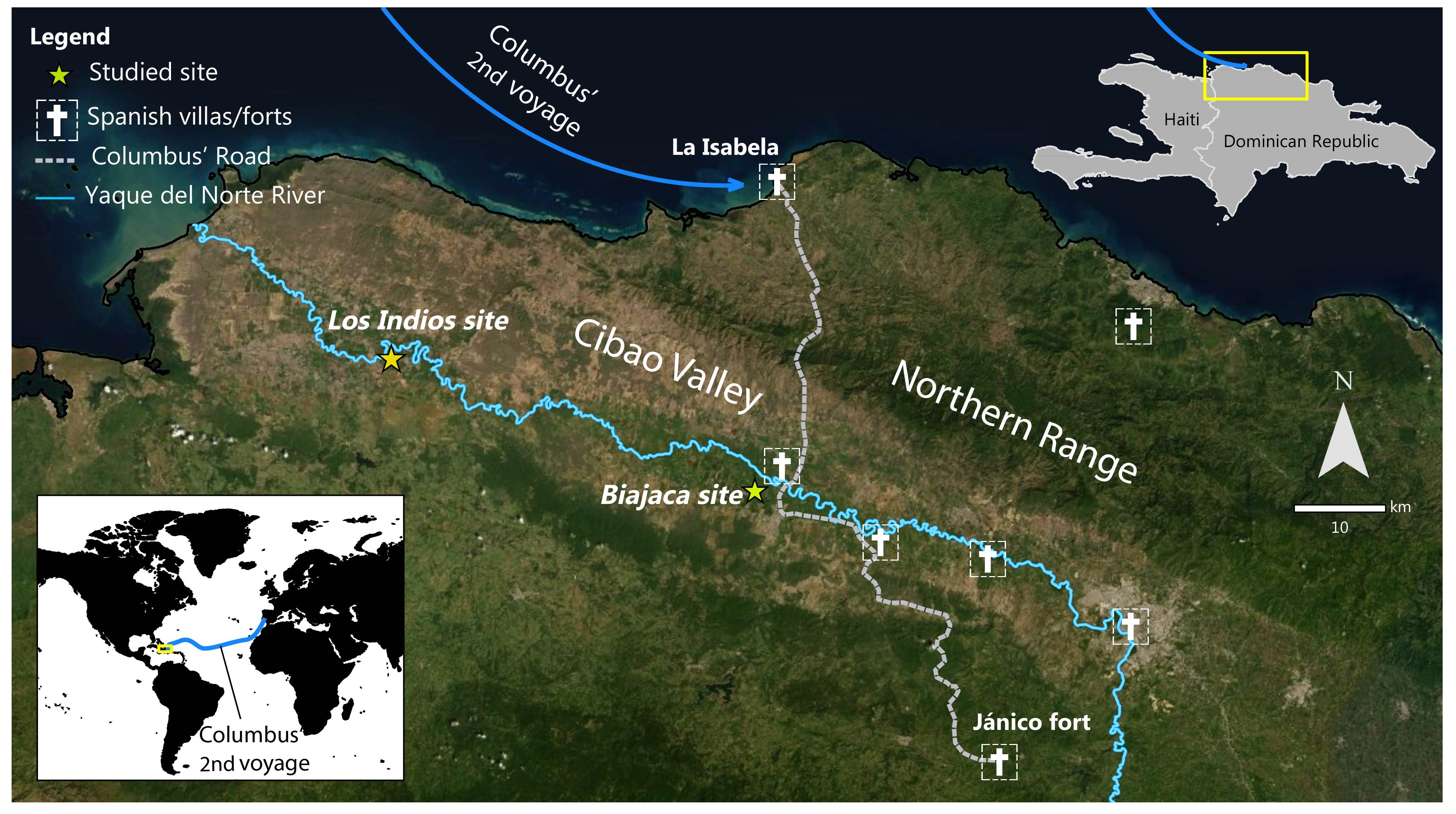
In 1492 CE Columbus landed in the "New World". In 1494 CE he founded La Isabella, the first colonial town in the Americas, located at the northern coast of the current Dominican Republic (Haytí island; Fig. 1; Ortega 1988). Five hundred years of colonial exploitation followed, which had far-reaching impacts for the indigenous people and local landscapes (Hofman et al. 2014; Siegel et al. 2015). Paleoecological analyses of sediment cores collected in sediment-filled meanders of the Yaque del Norte River (Cibao Valley) show the regional environmental history. Pre-Columbian indigenous land use had an impact on the forests of the valley. Depopulation due to post-contact epidemics and warfare was a major driver of dramatic landscape change.
 |
|
Figure 1: Map of Cibao Valley and the Yaque River in the northern Dominican Republic, Caribbean archipelago. "Haytí island", later called "Hispaniola" by the European colonists, today includes Haiti and the Dominican Republic. |
Sources of information
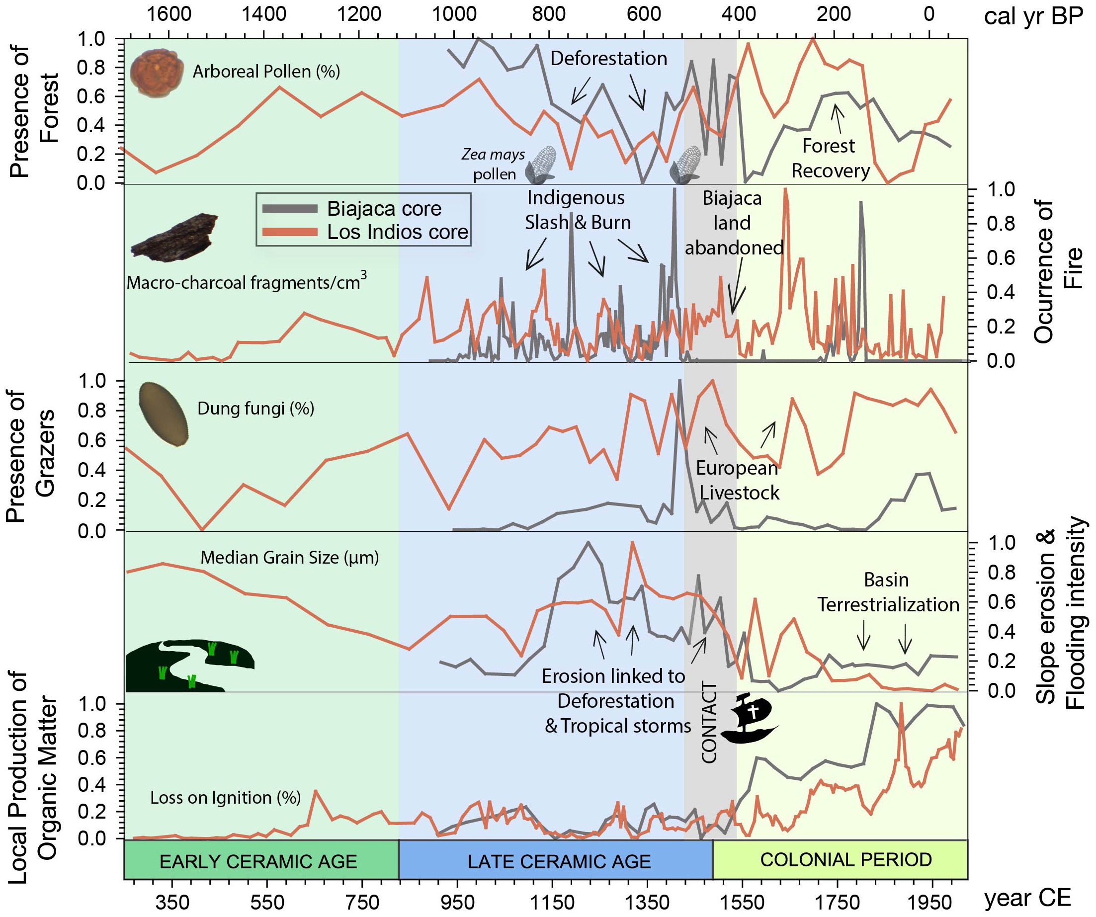
Changes in land use were studied from various threads of paleoecological evidence. Organic matter was radiocarbon-dated and provided a time scale for the sediment column. The records of fossil arboreal and herbaceous pollen and phytoliths (silica structures occurring in plant cells characteristic of specific groups of plants) show terrestrial vegetation changes. Non-pollen palynomorphs (e.g. spores of coprophilous fungi) are indicative of land-use changes, as they provide evidence of the presence of big mammals, and these changes in abundance are indicative of the introduction of European cattle. The record of charcoal documents the fire history (increased fire ocurrence indicates deforestation to develop agriculture) and the plant macrofossils show the composition of local wetland vegetation. Grain size analysis shows the changing energy levels of the river (coarse-grained silt and sand reflects intense flooding and fine-grained clay standing water) and the proportion of organic matter in the sediments reflects the abundance of aquatic vegetation. Fossil pollen of food plants and phytoliths show which food plants have been grown through time. All these threads of evidence come together to reveal a detailed account of how people have interacted with the landscape during the last 1800 years (Fig. 2).
The sediment core from site Biajaca reflects the last 1100 years (see Castilla-Beltrán et al. 2018). Biajaca is centrally located in the Cibao Valley ca. one kilometer away from the Columbus Route (Ruta de Colón), connecting the northern coast with the mountainous interior. This first informal "road" in the New World allowed for the transportation of gold and other products. At a kilometer distance from Biajaca, there is an archaeological site of an indigenous settlement. The sediment core from site Los Indios, some 40 km to the west, shows the last 1800 years (see Hooghiemstra et al. 2018). Both records together show a fascinating view of human activities before and after European incursion in the Americas.
Pre-Columbian landscape changes
The translocation of continental domestic plants, such as maize, chilli pepper, and sweet potato was a process that started from the first peopling of the Caribbean, around 7800 years ago (Pagán-Jiménez et al. 2015). In two later main pulses of migration, around 3500 and 500 BCE, the islands of the archipelago were populated by indigenous communities (Hofman et al. 2018). Until ca. 1400 CE, human impact on the environment of the studied area consisted of slash-and-burn practices to open areas for the cultivation of crops such as maize (Zea mays) and squash. This is evidenced by sustained charcoal deposition and the presence of pollen and phytoliths of these cultivars in the Biajaca record. Settlements were probably distributed in a mosaic structure, leaving relatively little disturbed forest on the floor of the Yaque River.
 |
|
Figure 2: Paleoenvironmental change, Cibao Valley (Dominican Republic): multiple lines of evidence from the Biajaca and Los Indios sediment cores. Measured values have been normalized (varying between 1 and 0). The records show the last ca. 1800 years of landscape and land-use changes in the Cibao Valley. |
The impacts of European colonization
The period from 1450 CE to ca. 1650 CE shows increasing human impact on the landscape. Columbus encountered a relatively densely populated valley with agricultural production on mounds and river terraces. Introduced European diseases decimated the indigenous population (Koch et al. 2019). This is evidenced by the absence of charcoal deposition at the Biajaca record and in the forest regrowth in both records. First colonists introduced cattle from the Iberian Peninsula; this is shown by more abundant spores from coprophilous fungi in a more open landscape. The island was becoming a hub for further exploration and occupation of the Caribbean and Central America, and chronicles report an intense conflict between Spanish colonizers and indigenous people (Hofman et al. 2018). At the same time, enslaved people from Africa were brought to the island. Ruderal plants (Artemisia, Plantago, and representatives of the Boraginaceae, Polygalaceae, and Brassicaceae families) are indicative of ecological succession in abandoned agricultural fields and cleared forest plots. Introduced taxa from the Old World, such as Rubus, also appear in the pollen record.
Near the middle of the 16th and 17th centuries, the charcoal record shows an increase in fire, reflecting forest clearance in the surroundings of the Los Indios site (western Cibao Valley) and near the site Biajaca (along the Columbus Road) respectively. Aquatic vegetation started to develop, indicating that the meanders were isolated from the drainage system. More abundant organic matter accumulated in the oxbow lakes. The establishment of Typha, Sparganium, and Cyperaceae plants reflects local terrestrialization at the sampling site. A plethora of changes, such as increasing fire, deforestation, loss of arboreal taxa, and the appearance of cultivated plants (banana, and solanaceous plants, potentially including chili pepper and tobacco, which we currently cannot identify to the species level) reflect the introduction of monocultures on a large scale in the Cibao Valley. After independence in 1844 CE, forest remnants were burned and charcoal deposition gradually decreased. Today, plantations of banana and rice dominate in the Cibao Valley.
Significance
"Reading" the environmental information deposited in two sediment-filled meanders near the Columbus Route yielded new information about how indigenous people used the landscape in pre-Columbian times. Indigenous land use changed dramatically after 1492 CE. Colonizers immediately introduced cattle farming, and depopulation caused forest regrowth.
Some 150 years later, abundant use of fire deforested the Cibao Valley, and large-scale agriculture was developed to serve European and local markets. From the moment of independence of the Dominican Republic, this valley became an agricultural center and was largely cleared of forests. Proxy-specific reconstructions can uncover many details, and a multi-proxy synthesis shows how the landscapes of the island developed into the ones we see today. Understanding these historical developments is essential to better appreciate successive steps in human-driven environmental degradation in this Caribbean island from pre-Columbian times.
Acknowledgements
This research was funded by the Synergy NEXUS1492 project financed by the European Research Council under the European Union's Seventh Framework Programme (FP7/2007-2013) grant agreement 319209 directed by professor Corinne L. Hofman, Faculty of Archaeology, Leiden University, The Netherlands.
affiliations
1Faculty of Archaeology, Leiden University, The Netherlands
2School of Geography and Environmental Science, University of Southhampton, UK
3Department of Ecosystem and Landscape Dynamics, University of Amsterdam, The Netherlands
4Department of Earth Sciences, Vrije Universiteit, Amsterdam, The Netherlands
5Department of Physical Geography, Utrecht University, The Netherlands
6Lorentz Center, Leiden, The Netherlands
contact
Alvaro Castilla-Beltrán: a.castilla-beltran soton.ac.uk
Corinne Hofman: c.l.hofmanarch.leidenuniv.nl
references
Castilla-Beltrán A et al. (2018) Anthropocene 22: 66-80
Hofman C et al. (2014) World Archaeol 46: 590-609
Hofman C et al. (2018) Antiquity 92: 200-216
Hooghiemstra H et al. (2018) Holocene 28: 1818-1835
Koch A et al. (2019) Quat Sci Rev 207: 13-36
Ortega EJ (1988) La Isabela y la Arqueología en la Ruta de Colón. Editorial Universidad Central del Este, 100 pp