Flood hazard assessment from alluvial sediments: Data from sedimentology to place names

Antony G. Brown1,2, B. Pears2, P. Toms3, J. Carroll4, J. Wood3 and R. Jones5
Floods are a natural component of our environment, and are constantly changing due to both natural and human factors. However, they leave physical and societal evidence in sediments and place names.
An increase in late 20th- and 21st-century river floods in the UK and other parts of Europe, including France, Spain, Poland, and the Czech Republic, highlights the urgent need to better understand flood magnitudes and return frequencies across short (decadal to sub-centennial) to medium (centennial to millennial) timescales in order to prepare for future events. Key to generating robust predictive models is the ability to track, with greater precision and across greater expanses of time, the nature of past floods and to set these against the various climatic and anthropogenic factors that contributed to their occurrence. For the UK, the timeline for the formal recording of empirical observations revealing magnitude and reach of individual flood events is woefully short, rarely providing reliable data before the 17th century CE (Macdonald and Sangster 2017). Other evidence is needed to extend this record back through time. Since every flood leaves a physical signature of its passing, constructing chronostratigraphic models from alluvial sediments gives direct insight into fluvial activity potentially over millennia. Less obviously, we can draw upon the observations made by early medieval communities of river behaviors, initially communicated through, and now preserved within, the names they gave to riverside settlements.
Sedimentary histories
The use of fluvial sediments as flood archives has a long history. These are usually reconstructed in bedrock reaches where channel stability permits the cross-sectional area of floods to be calculated. This is more problematic in non-bedrock alluvial systems characteristic of lowland Britain and much of Europe. But where channels have stabilized, a flood archive is sometimes preserved in deep floodplain sediments. With advances in optically stimulated luminescence (OSL) dating, reliable to ±10% (1σ), these clastic sequences can be dated in the absence of organic material and, when analyzed using high-resolution proxies including X-ray fluorescence (XRF), provide insights into fluvial depositional conditions and flood events (Brown et al. 2013; Pears et al. 2020a; Pears et al. 2020b; Pears et al. in prep).
 |
|
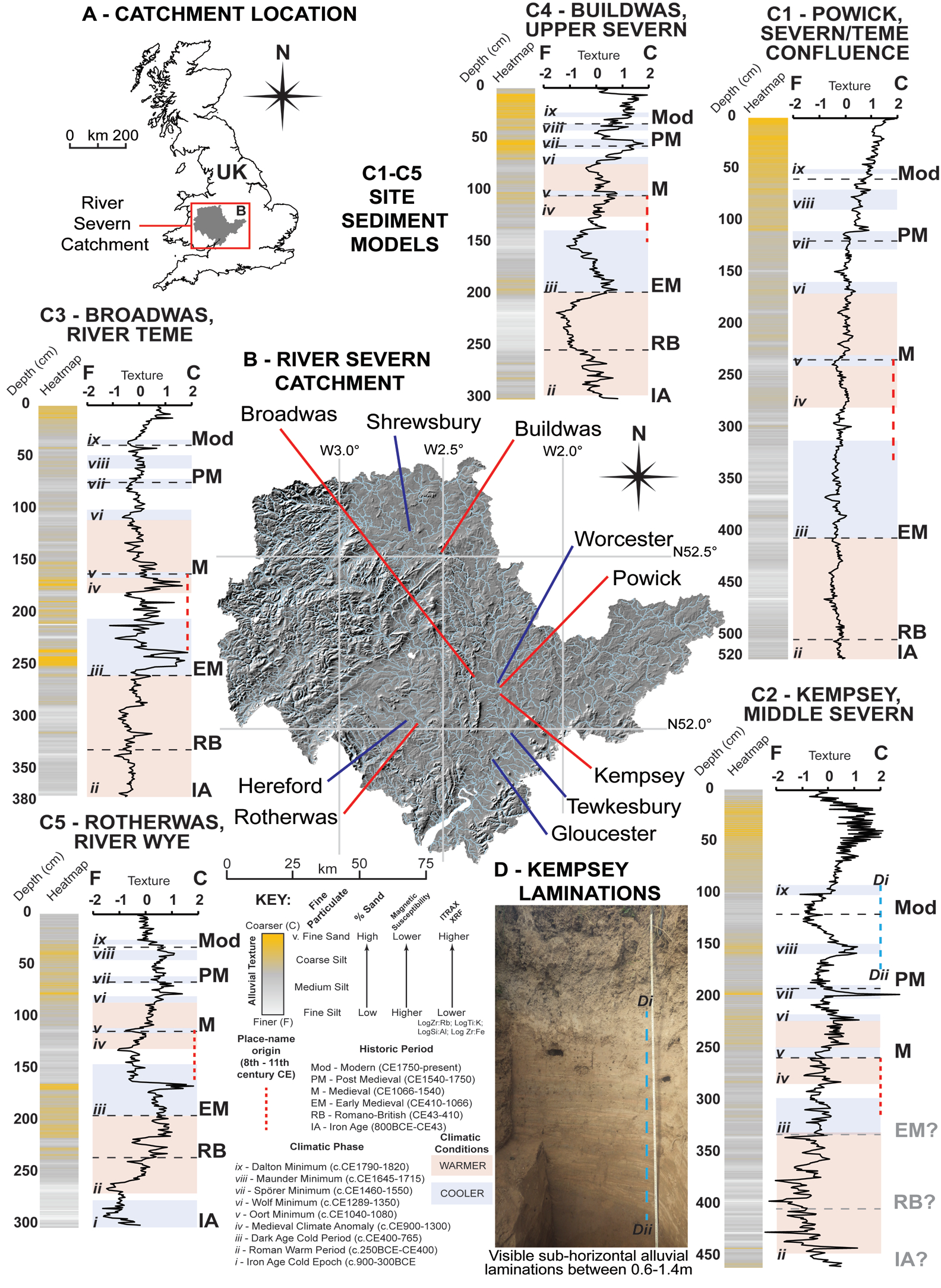
Figure 1: (A) River Severn catchment in UK; (B) Locations of sample sites (red) and urban centers (blue); (C) Reconstructed chronostratigraphic line and heatmap models of Late Holocene alluvial texture from (C1) Powick, (C2) Kempsey, (C3) Broadwas, (C4) Buildwas, (C5) Rotherwas. Models created from log-normalised data (Pears et al. 2020a; 2020b; in prep) and shown with climate phasing and place-name derivation; (D) Photographic record of Kempsey laminated sequence. |
Recent research at Powick, Worcestershire, UK, at the Severn-Teme confluence (Pears et al. 2020b) demonstrates channel stabilization from ca. 3500 years before present followed by unabated vertical floodplain accretion from the Middle Iron Age onwards (ca. 300 BCE). The results show subtle variations in depositional character from the start of the medieval period, with a dramatic increase in fluvial activity from the 16th century CE. Similar chronologies and fluvial signatures at other sites across the Severn catchment demonstrate broad correspondences in depositional character (Brown et al. 2013; Pears et al. 2020a). These can be set against the historical climate record and potential contributory anthropogenic factors, including land-use change, agriculture, and embanking (Lewin 2013; Macklin et al. 2014).
At Kempsey (Fig. 1), south of Powick, a recently analyzed sediment sequence contains exceptionally well-preserved coarse flood laminations (Pears et al. in prep). These laminae can be correlated with relative confidence to historically attested major floods between ca. 1600 and ca. 1840 CE and to other unrecorded flood events (Macdonald and Sangster 2017). Tellingly, a correlation can be demonstrated between flood-rich periods and the two significant solar minima of this period, the Maunder Minimum (ca. 1645–ca. 1715 CE) and Dalton Minimum (ca. 1790–ca. 1830 CE), indicating solar activity as a potentially significant contributory factor in the behavior of the Severn. Critically, these laminae permit us to estimate the discharges of some of the largest recorded historic events. They also indicate that the return frequency of floods might vary significantly across time. The Severn's response to Maunder and Dalton differed. This has implications for understanding future flooding, particularly since it is predicted that we are entering the next Grand Solar Minimum.
Name histories
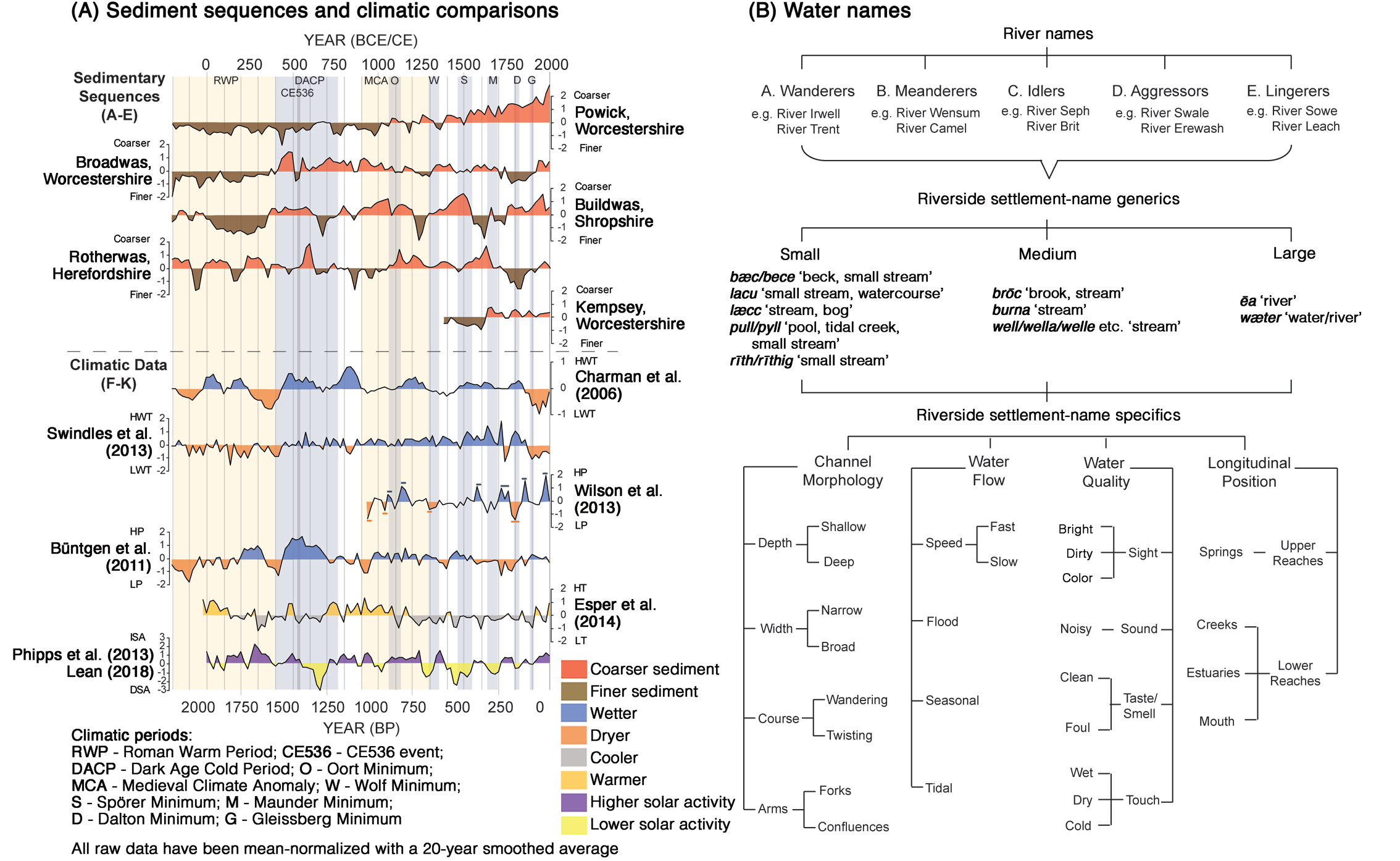
Many British river names tell us something about their general geomorphological and hydraulic characteristics. These include names which describe channel sinuosity and rates of flow (Fig. 2b). However, more specific and localized information is more often encountered in riverside settlement names. Place names originated as meaningful descriptions which arose in everyday speech or within administrative contexts. In England, most town and village names were formed between the 8th to 11th centuries CE in early varieties of English (Old English) and Scandinavian (Old Norse). They inform on the historic landscape, including riverine behavior (Jones 2016; Jones et al. 2017). Place names record types of watercourse (e.g. Southwell: "south spring"), water behavior (Averham: "[settlement] at the floods") and wetland areas (various settlements named Ham: "wetland, water-meadow"). Place names also record wetland-loving flora (Kersal: "cress nook"), fauna (Frostenden: "frog valley"), and suggestive geology (Slapton: "slippery place"). Names of riverine settlements relate to river form and topography. For example, names containing Old English hamm: "land hemmed in by water or marsh" (Gelling and Cole 2000) typically refer to locations in lower reaches within areas of shallow gradient and dominant river meanders. These sites are still subject to prolonged flooding with much of the floodplain underwater for extended periods (Gelling 1984). In contrast, names containing terms for "river crossings", Old English ford and Old Norse vath, are found where gradients become steeper, resulting in shallower river depth, and are often associated with weirs.
Landscape terms within place names were used with a high degree of specificity. Some speak directly of flooding. Old English wæsse, "land which floods and drains quickly" (Gelling and Cole 2000), is attached to key locations in the West Midlands where there is a distinctive change in floodplain morphology. It is found in Buildwas, where the Severn enters the Ironbridge Gorge, in Broadwas, at a distinctive widening on the Teme, and in Rotherwas on the Wye, as it meets the Lugg. Such names comment on historical riverine behaviors, and, when assessed with geoarchaeological evidence, the responses of inhabitants to those behaviors.
Place names and sedimentological analysis
Those who coined place names 1000 years ago knew that wæsse-sites flooded. Flooding remains a frequent occurrence in these locations. But what was the specific character of flooding in these places that merited the use of a special term, seemingly inappropriate for floodable areas elsewhere? Sedimentological analysis has revealed the fluvial characteristics of the rivers – the Severn, the Teme, and the Wye – at these locations from the Iron Age to the present day (Fig. 1). Consequently, it is possible to set this early medieval flood term against the contemporary physical record for flooding (Pears et al. 2020a).
 |
|
Figure 2: (A) Comparison of Severn-catchment decadal sediment deposition models modeled against upland peatland watertable depth and proxy wetter/drier conditions in the UK and Ireland; precipitation in Southern and Central England and Central Europe; Northern European temperatures and solar activity (Pears et al. 2020b). (B) Hydrological information relating to flowing water retained within river and place names (adapted from Jones 2016). |
Coarse alluvial sediments at Broadwas and Buildwas indicate that high-energy river deposition conditions characterized, albeit with some chronological variation, the period from the 5th to the 13th centuries CE. A more mixed picture emerges at Rotherwas where the Wye appears to have been particularly energetic during the 6th and 7th centuries CE and again from the 14th century (Pears et al. 2020a). Noteworthy in all three cases is that the onset and conclusion of individual flood events appears to have occurred rapidly, even if floodwaters inundated the entire floodplain. It would appear that it was the fast rising and quick draining in these locations that place-namers sought to convey in the term wæsse.
In combination, place names and sedimentological analysis therefore permit the reconstruction of a longer and more-precise chronology of floods, and help to assess their nature and magnitude. River behaviors can thus be correlated with potential climatic drivers, particularly the influence of solar irradiance (Phipps et al. 2013; Lean 2018), but also fluctuations in temperature (Büntgen et al. 2011; Esper et al. 2014), precipitation (Charman et al. 2006; Swindles et al. 2013; Wilson et al. 2013), and storminess – especially during the Dark Age Cold Period (400–750 CE), and Medieval Climate Anomaly (900–1300 CE) – as well as anthropogenic factors such as woodland clearance and arable expansion (Fig. 2a).
Future perspectives
Our work helps to determine non-stationarity in flood series and better integrate natural and societal evidence to understand depositional regime change over time. This potentially enables us to recalculate, or better define, major flood return intervals under certain climatic conditions. These may be significantly lower than previously estimated, with obvious future design and flood management implications. Despite their age, warnings of flood-prone locations and other indications of riverine activity communicated through historic place names can also be shown to be relevant today. These insights from the past can help us better prepare for the future.
affiliations
1The University Museum Tromsø, Arctic University of Norway, Norway
2School of Geography and Environmental Science, University of Southampton, UK
3Luminescence Dating Laboratory, School of Natural and Social Sciences, University of Gloucestershire, Cheltenham, UK
4Institute for Name-Studies, University of Nottingham, UK
5Centre for English Local History, University of Leicester, UK
contact
Tony Brown: antony.g.brown uit.no
references
Brown AG et al. (2013) Anthropocene 1: 3-13
Büntgen U et al. (2011) Science 331: 578-582
Charman DJ et al. (2006) Quat Sci Rev 25: 336-350
Esper J et al. (2014) J Quat Sci 29: 487-494
Gelling M (1984) Place Names in the Landscape. Dent, 326 pp
Gelling M, Cole A (2000) The Landscape of Place-Names. Shaun Tyas, 416 pp
Jones RLC (2016) J Ecol Anth 18: 1-25
Jones R et al. (2017) Eur J Post-Clas Arch 7: 33-64
Lean JL (2018) Earth Space Sci 5: 133-149
Lewin J (2013) Earth Surf Proc Land 38: 17-29
Macdonald N, Sangster H (2017) Hydrol Earth Syst Sci 21: 1631-1650
Macklin MG et al. (2014) Anthropocene 6: 26-38
Pears B et al. (2020a) Eur J Archaeol 23: 381-405
Pears B et al. (2020b) Geology 48: 819-825
Phipps SJ et al. (2013) J Clim 26: 6915-6936