- Home
- Publications
- PAGES Magazine
- Pre-Columbian Legacy and Modern Land Use In The Bolivian Amazon
Pre-Columbian legacy and modern land use in the Bolivian Amazon
Umberto Lombardo
31(1)
16-17
2023
Here, I present a case where large extensions of seasonal wetlands in the Bolivian Amazon are being transformed into monoculture deserts. Yet, farmers can argue that their practices do not differ from pre-Columbian landscape transformations around 1000 years ago.
One of the reasons for studying the past is that we can learn from it. Learning about past human–environment interactions can guide and inspire us towards adopting more sustainable practices in the face of anthropogenic global warming and environmental change (Boivin and Crowther 2021). However, past models of huma–environmental interactions cannot always be transferred into our modern societies, as environment, technological and cultural contexts change across time and space.
The Monumental Mounds Region
The Monumental Mounds Region (MMR), in the center of the Llanos de Moxos in the Bolivian Amazon, hosts hundreds of monumental mounds built by the Casarabe culture between roughly 2000 and 500 years ago (Lombardo and Prümers 2010; Prümers et al. 2022). These mounds are human–made architectural structures that can reach up to 20 meters in elevation and cover up to 20 hectares. They are the remains of the only example of agrarian-based, low-density urbanism in pre-Hispanic Amazonia (Prümers et al. 2022). Monumental mounds have a hierarchical organization and are connected by hundreds of kilometers of canals and causeways. This level of social complexity would not have been possible without a very productive agricultural system. Pollen records from San José Lake (Whitney et al. 2013) and microbotanical remains from pottery (Dickau et al. 2012) suggest that maize was an important element of the diet at that time.
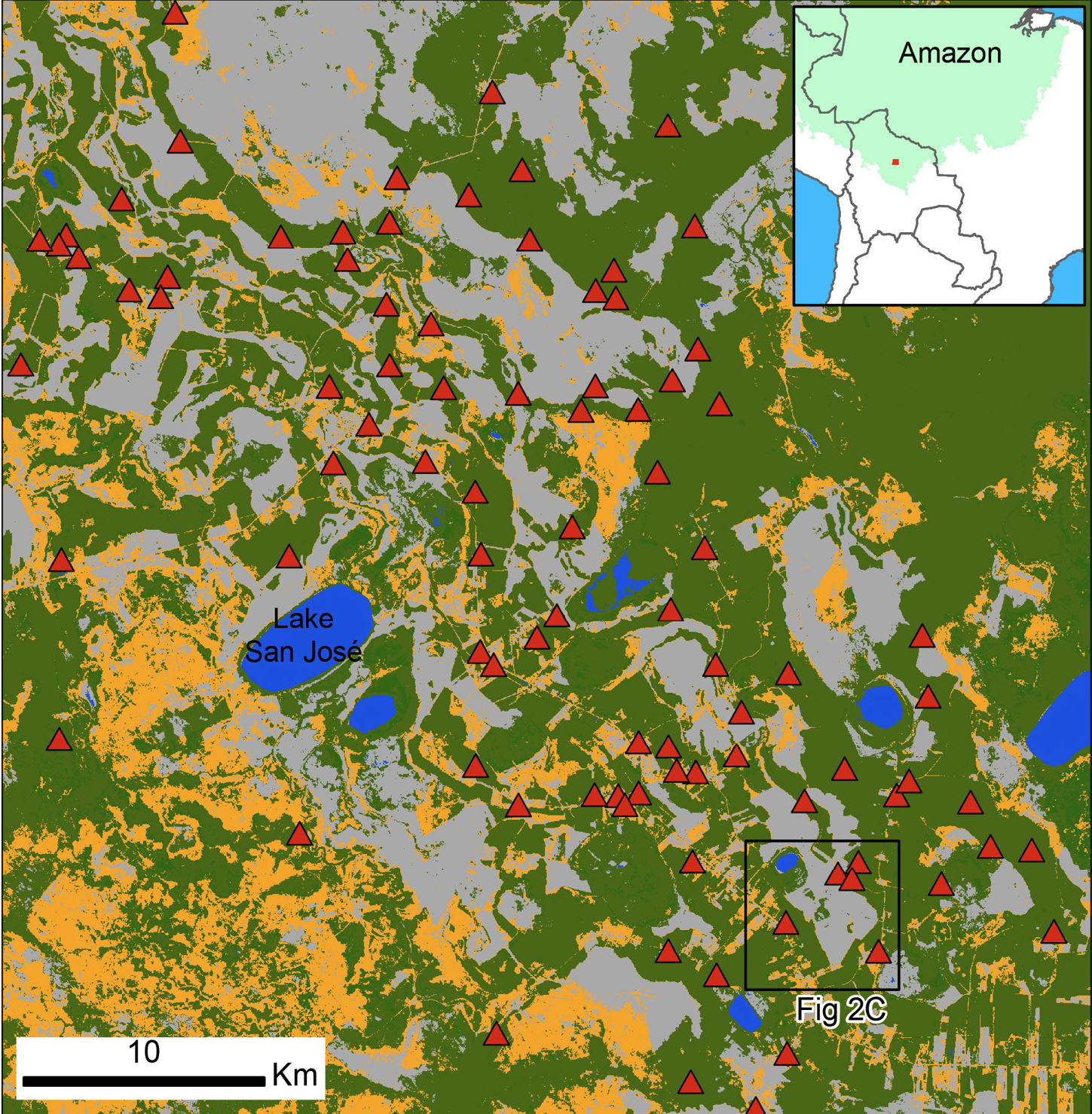
Nowadays, this region is at the forefront of the expansion of the agriculture frontier (Ormachea 2021), witnessing a sharp transition from cattle ranching to soy and rice production. This transition is having a large impact on the savanna, as land use is shifting from grazing to intensive, mechanized agriculture. Figure 1 shows the current land cover (based on Copernicus Sentinell-2 data, retrieved from Scientific Data Hub, Level-2A processed by ESA) of the central part of the MMR, with almost half of the savanna formerly used for cattle grazing now being cultivated. While slash and burn agriculture has been a common practice by Indigenous peoples in the forested areas, it is the first time since the collapse of the Casarabe culture that these savannas are being cultivated (Killeen et al. 2008).
Pre-Columbian agriculture in the MMR
When compared with the rest of the Amazon basin, the MMR has high agricultural potential because it is established on relatively recent fluvial sediments. Thousands of years ago, the Río Grande, a large river that today flows into the Mamoré River from east to west, followed a different course: it went from south to north, passing across the very area where the MMR is located. Due either to a change in climate conditions (Mayle et al. 2000) or a tectonic uplift (Lombardo 2014) the Río Grande started to repeatedly change its course, creating a delta-like environment at around 4 kyr BP. During this period of avulsions (i.e. rivers changing course because of floods outpacing natural margins or fluvial levees), the Río Grande deposited a huge amount of Andean sediments in what is now the MMR. Here, the Río Grande created two types of relief; a lens of sediments up to four meters thick over an area of approximately 2600 km2 that formed a sedimentary lobe, and a number of fluvial levees (Lombardo et al. 2012). The modern land cover of the MMR is the result of these geomorphological processes. Most of the sedimentary lobe is now covered by seasonally flooded savanna established over backswamp deposits, while the paleo-levees, which remain above the water level almost the whole year, are forested (Fig. 1).
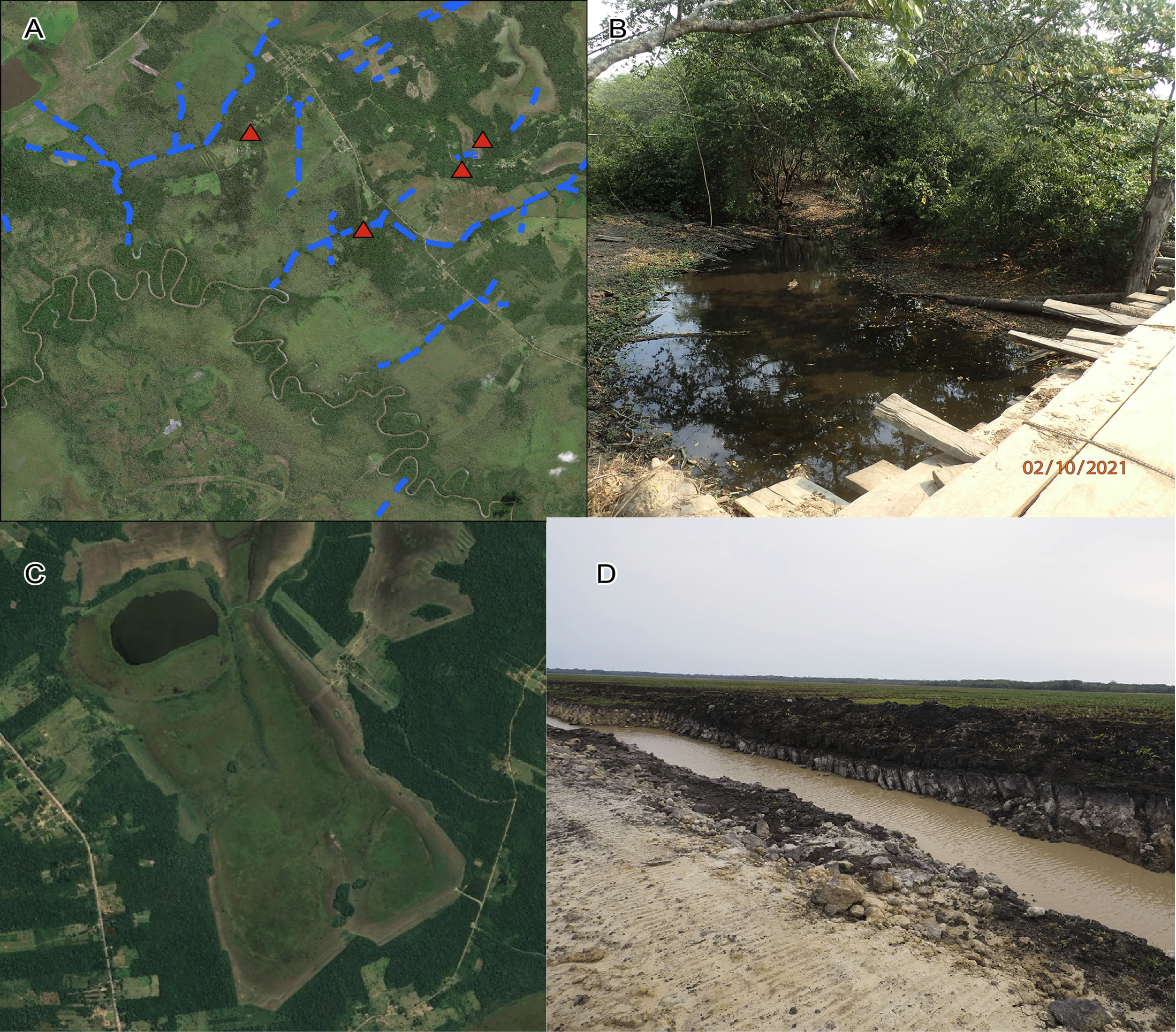
The sedimentary lobe provided relatively fertile and better drained soils than the rest of the Llanos de Moxos (Lombardo et al. 2013) and its topography determined the settlement patterns in the MMR. In fact, the monumental mounds were always established along paleo-channels, often along the inner part of the meanders (Lombardo and Prümers 2010). Despite the fact that the formation of the sedimentary lobe in the MMR brought about several agricultural benefits, the paleo-channels also created conditions of poor drainage. Fluvial levees enclosed the patches of backswamp floodplain, resulting in ponding and pronounced waterlogging. Thus, in order to make full use of the MMR’s agricultural potential, the Casarabe culture transformed the landscape through the construction of a drainage system (Lombardo et al. 2012). This was achieved by digging canals that cut through the paleo-levees (Fig. 2a) and connected the savannas to the rivers. In so doing, the Casarabe culture managed to speed up the drainage of the savannas at the end of the rainy season and made it possible to farm in the savanna.
Modern agriculture in the MMR
Even though most of the pre-Columbian drainage canals have been partially infilled with sediments, the overall network still plays an important role in speeding up drainage at the end of the rainy season. Figure 2b shows a picture of an active pre-Columbian drainage canal. Over the past years, this partially functioning drainage system has allowed farmers to cultivate the outer part of the savannas, along the border with the forest where the elevation is higher, while the inner part of the savanna has been left intact (Fig. 2c). By doing this, modern farmers have taken advantage of a pre-Columbian legacy.
More recently, however, farmers have started to cultivate the whole savanna. By excavating new drainage canals (Fig. 2d), farmers are now draining the deeper part of the savanna. The peat accumulated over the last few centuries is now drying, and it will be later burnt with the consequential release of tons of CO2 into the atmosphere. What in pre-Columbian times was a collective effort of landscape transformation and management that probably took decades to implement, is now a large-scale, land-use change that only requires a few months of intensive tractor use. Yet, objectives and results are basically the same: draining the wetlands to make space for agriculture.
affiliations
1Institut de Ciència i Tecnologia Ambientals (ICTA-UAB), Universitat Autònoma de Barcelona, Spain
2Department of Prehistory, Universitat Autònoma de Barcelona, Spain
contact
Umberto Lombardo: umberto.lombardo uab.cat
references
Boivin N, Crowther A (2021) Nat Ecol Evol 5: 273-284
Dickau R et al. (2012) J Archaeol Sci 39: 357-370
Killeen TJ et al. (2008) Ecol Soc 13: 36
Lombardo U (2014) Earth Surf Dynam 2: 493-511
Lombardo U et al. (2012) The Holocene 22: 1035-1045
Lombardo U et al. (2013) Quat Int 312: 109-119
Lombardo U, Prümers H (2010) J Archaeol Sci 37: 1875-1885
Mayle FE et al. (2000) Science 290: 2291-2294

