- Home
- Publications
- PAGES Magazine
- Human–environment Interactions In South Asian Watersheds Over The Last 100 Years: A Multi-disciplinary Analysis of Talavs
Human–environment interactions in south Asian watersheds over the last 100 years: A multi-disciplinary analysis of talavs
Atreyee Bhattacharya, J.S Leonard-Pingel, S. Sarkar, G. Arora, R. Ray, A. Ambilili, A.V. Michelson, P.K. Mishra, M. Desimone, S. Chakraborty, P. Sabale, K. Bajaj, A. Bhattacharya, R. Balaji and A. Bazaz
Past Global Changes Magazine
31(1)
22-23
2023
Atreyee Bhattacharya1,2,3, J.S. Leonard-Pingel4 S. Sarkar5, G. Arora3, R. Ray2,3, A. Ambilili6, A.V. Michelson7, P.K. Mishra6, M. Desimone1 S. Chakraborty8,9, P. Sabale10, K. Bajaj8,11, A. Bhattacharya12, R. Balaji1 and A. Bazaz2
Human-made water bodies, called talavs, are common features of arid and semiarid regions of South Asia. Multi-disciplinary research into these talavs demonstrates untapped potential to investigate the long-term response of coupled human–environment systems to climate fluctuations in these regions.
Rain-fed watersheds in arid and semiarid regions of South Asia – home to millions, and host to major agricultural and urban centers – are some of the most vulnerable climate hotspots (regions that experience pronounced and well-documented impacts of anthropogenic climate change; Khan and Cundill 2019). Anthropogenic climate change, combined with rapid changes in land-use patterns (e.g. agriculture and urbanization), has degraded natural resources in these watersheds resulting in increased economic stress, social instability and escalating conflict (ASSAR 2018). In order to formulate better solutions to manage water resources in these hotspots, there is mounting demand from both scientists and policymakers for an improved understanding of the relationship between human communities and natural resources, especially under different climate scenarios.
The famous American poet Robert Penn Warren observed, "History cannot give us a program for the future, but it can give us a fuller understanding of ourselves, and of our common humanity, so that we can better face the future." Watersheds in arid and semiarid regions of South Asia, which have witnessed human settlement for millennia, represent a tight coupling of human–environment interactions that have evolved over the longue durée* in response to a complex interplay of climatological, environmental, cultural and historical events (Ray et al. 2021). However, studies documenting how human societies have responded to water bodies in these climatologically threatened watersheds over the longue durée are lacking. Here we explore a unique, but ubiquitous, type of surface water body – human-made surface water bodies called talavs – to understand the evolution of human responses to water resources in semiarid climate hotspots of western India during documented periods of climate fluctuations.
*Longue durée means "long duration" and is used to describe the effects of events that occur slowly enough to be imperceptible, and allows studies of human history to accommodate climatology, demography, geology, and oceanography (Braudel 2009).
What are talavs? Why and how do we study them?
In arid and semiarid regions of South Asia, a unique type of surface water body, created by damming tributaries and distributaries of seasonal rain-fed river channels, are ubiquitous. The dammed river channels, colloquially known as talavs, are mentioned in archaeological studies (Shanmugasundaram et al. 2017), historical texts and in contemporary policy literature (ASSAR 2018) in relation to water access for the purposes of sustenance, agriculture, communication and urbanization. Talavs typically have an area of ~2–5 km2 and catchment areas ~30–100 km2. Owing to their small size and continued presence over the longue durée, talavs can provide much-needed insights into the nature and causes of evolution of catchment level human–environment interactions under different climate scenarios that are important for policy and planning.
To capture human–environment interactions spanning the lifetime of these talavs, we combine a natural sciences approach with a social sciences perspective. The natural sciences approach involves understanding the state of the water bodies today (e.g. by using remote sensing, geophysical surveys, and biogeochemical analyses) and in the past (e.g. by studying similar downcore properties in sediment cores extracted from lake bottoms). The social lens, on the other hand, involves understanding the human use of these water bodies in the past (e.g. by extracting information related to the talavs from archived administrative colonial texts) and in contemporary times (e.g. by conducting in-depth interviews with stakeholders). We call this novel, mixed method of studying water bodies "the four-pronged approach".
Human–environment interactions in semiarid west Indian watersheds
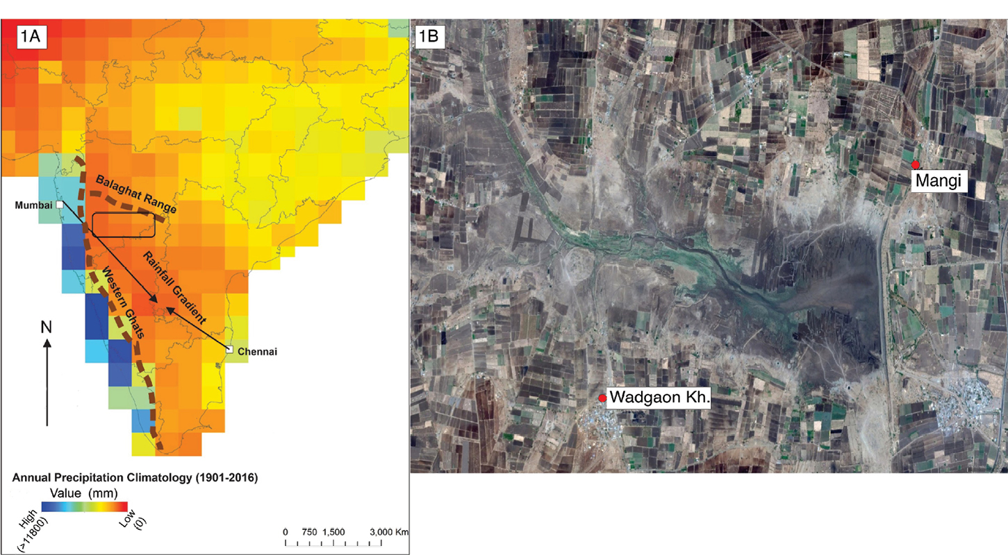
Semiarid regions of western India that overlie the Deccan Traps, and lie in the rain shadow of the Western Ghats (Sahyadri mountain range) running parallel to the western coast of India, is a well-known climate hotspot (ASSAR 2018, Fig. 1a). Talavs are ubiquitous in this region (Fig. 1b). We apply our novel "four-pronged approach" to investigate talavs in several catchment areas of our study area, the Bhima watershed (outlined in Fig. 1a). We list some of our observations below.
 |
|
Figure 1: (A) Study area outlined by the box. (B) Aerial (Google Earth) image of a dammed river in the study area that serves as a human-made talav. |
(a) Combining remote sensing, geophysical surveys and downcore analyses (grain size, X-ray fluorescence and radiometric dating), we found that talavs serve as sedimentary archives recording erosional patterns in the catchment. The erosional patterns are affected by the local environmental (e.g. vegetation) and geological (e.g. slope) factors within the catchment, and the type of structure (e.g. age, height, composition, rate of maintenance of the dams). However, we find that it is the catchment-level manifestation of the large-scale Indian monsoon system that has the strongest impact on the erosional patterns preserved in the sediments of the talavs. Furthermore, we found that drier catchments in the Bhima watershed are at elevated risk of floods caused by anomalous heavy rainfall events in these catchments. Floods cause loss of top soil that is detrimental to farmers, who are the main stakeholders in the area.
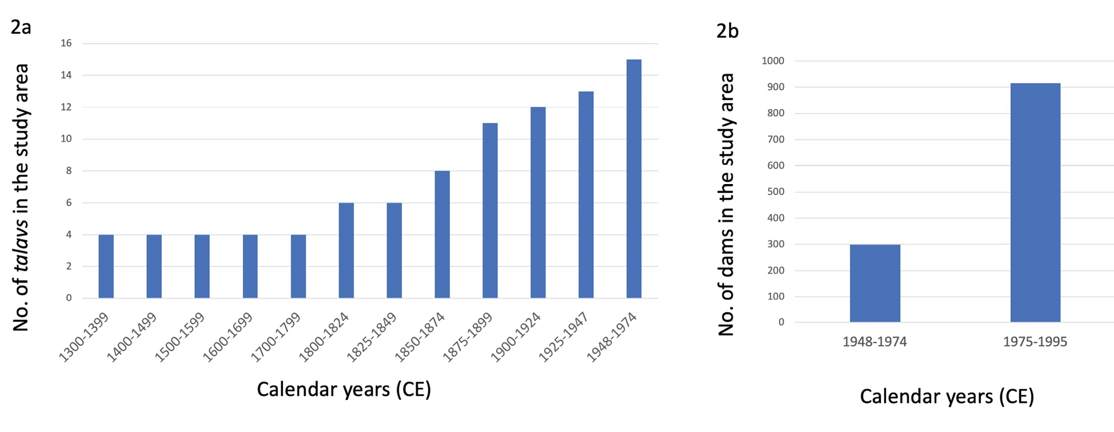
(b) Analysis of information extracted from colonial administrative texts demonstrates that the talavs were first built in this region by the Mughals (~1500 CE) to provide water to local populations during dry spells. Later, the British colonialists, taking advantage of the fertile soil, developed this region intensively during the 18th–20th centuries as a cash crop agricultural center (first cotton, and then sugarcane). They did so by commissioning talavs (Fig. 2a) in response to famines (extreme food shortages associated with low rainfall; Ray et al. 2021) to serve two purposes, namely water conservation for agricultural purposes and to provide non-farm (alternate) sources of employment for local populations during famine years (Ray et al. 2021). After India gained independence in 1947, the government of India undertook a massive construction effort to build large (>15 m high) and small (<10 m high) dams to further increase water-intensive cash crop production (sugarcane) and generate hydroelectricity (Fig. 2b). The construction of talavs was key to preventing food shortages caused by rainfall variability in these semiarid regions and, eventually, turning the region into a major urban center and port.
(c) However, in-depth interviews with stakeholders conducted recently, especially with farmers, revealed that the presence of talavs has changed the nature of climate risks upstream and downstream of these water bodies. Farmers in the upstream region are more vulnerable to rainfall fluctuations than farmers in the downstream region, even though they are only 5 km apart. Downstream farmers continue to grow water-intensive crops like sugarcane and fruits (grapes, bananas), while upstream agriculture comprises less water-thirsty crops, such as millets. This differential access to water has resulted in unequal wealth distribution in the catchment area. In fact, newspaper reports suggest that in recent decades, hoarding of water in these talavs by powerful farmers may have escalated conflict and exacerbated existing inequalities, as demand for water has increased with growing reliance on water-intensive cash crops (Fig. 2b).
 |
|
Figure 2: The proliferation of talavs in the study area. (A) Historical (1300–1974) proliferation of talavs in the study area. Source: Maharashtra State Gazetteers, India, gazetteers.maharashtra.gov.in. (B) Increase in the number of dams during the second half of the 20th century (1948–1995), most of which were constructed in the same way as the historical talavs. Source: Govt. of Maharashtra, India, maharashtra.gov.in. |
Implications for policy and climate research
Talavs provide catchment-level information on parameters such as the rate of loss of top soil, flood risk, etc. that are critical for informing policy and drawing management plans. Climate information preserved in sediments collected from the talavs also helps ground truthing downscaled climate models, critical for local climate prediction purposes. But most importantly, talavs provide invaluable insights into how human communities, based on their socioeconomic and cultural realities, respond to climatic changes. These insights address relevant climate–society questions such as human migration and conflict. Scientific exploration of small water bodies (Jacob et al. 2020; Penny et al. 2007) require multi-disciplinary and creative approaches, which can be logistically challenging and cost prohibitive to undertake. However, considering the value these explorations provide in understanding climate–society linkages, more studies should be undertaken. Finally, engaging with local populations, who use such resources to sustain their communities in a reciprocal manner, offers an opportunity for a more community-engaged approach to paleoscience.
Acknowledgements
We thank the Maharashtra Forest and Irrigation Department, the Unique Group and Amey Datye (IITM-Pune) for assisting in the fieldwork.
affiliations
1CIRES and Center for Asian Studies, University of Colorado, Boulder, USA
2Indian Institute for Human Settlements (IIHS), Bengaluru, India
3Indraprastha Institute of Information Technology (IIIT), New Delhi, India
4Ohio State University, Newark, USA
5Indian Institute of Science Education and Research (IISER), Pune, India
6Indian Institute of Science Education and Research (IISER), Mohali, India
7State University of New York Maritime College, USA
8Indian Institute of Tropical Meteorology, Ministry of Earth Sciences (MoES-IITM), Pune, India
9Pune University, India
10Deccan College-Deemed University, Pune, India
11University of British Columbia, Vancouver, Canada
12Indian Institute of Technology (IIT), Kharagpur, India
contact
A. Bhattacharya: atreyee.bhattacharya colorado.edu (atreyee[dot]bhattacharya[at]colorado[dot]edu)
references
ASSAR (2018) Adaptation at Scale in Semi-Arid Region. Report on Maharashtra, accessed on 5 April 2023, www.assar.uct.ac.za/assars-work-maharashtra
Braudel F (2009) Review (Fernand Braudel Center) 32(2): 171-203
Jacob R et al. (2020) Anthropocene 68(3): 100238
Khan AS, Cundill G (2019) Ambio 48: 639-648
Penny D et al. (2007) Nucl Instrum Methods Phys Res B 259: 388-394