- Home
- Publications
- PAGES Magazine
- Advancing Last Interglacial and Holocene Sea-level Databases
Advancing Last Interglacial and Holocene sea-level databases
Alessio Rovere, S.G. Alvarado, J.M. Doherty and N. Khan
Past Global Changes Magazine
31(1)
51
2023
Alessio Rovere1,2, S.G. Alvarado3, J.M. Doherty4 and N. Khan5
The PAGES Data Stewardship Scholarship program contributed to the development of an online database interface and a visualization tool of past sea level by the PALSEA working group.
The creation of reporting standards for sea-level proxies and the compilation of sea-level databases have been a central focus of the PALeo constraints on SEA level rise (PALSEA) working group (pastglobalchanges.org/palsea) since its inception (Düsterhus et al. 2016; Rovere and Dutton 2021). Over the last three years, these efforts came to fruition with two products. First, a global database of post-Last Glacial Maximum (LGM) sea-level index points was created within the Geographical variability of Holocene sea level (HOLSEA) project (Khan et al. 2019). Second, the creation of the World Atlas of Last Interglacial Shorelines (WALIS; Rovere et al. 2022) database, which includes sea-level proxies dating back to Marine Isotopic Stage (MIS) 5.
With the completion of these two databases, ideas started to arise concerning the feasibility of uniting them under a single interface and the availability of visualization and interfaces to allow for their exploration, and facilitate data query and download. With these ideas in mind, we submitted a proposal for a Data Stewardship Scholarship to PAGES. The proposal had two primary goals. The first was to implement the Holocene sea-level data standard format (Khan et al. 2019) into the interface built for the WALIS database (available here: alerovere.github.io/WALIS), eventually duplicating the database done within the HOLSEA project into WALIS. The second goal was to provide a visualization interface for the WALIS data, taking inspiration from the one already proposed for the HOLSEA database (Drechsel et al. 2021).
The first result of our work was the implementation of the HOLSEA data template into the WALIS database structure, including the online database interface. This work is now complete. As a result, any user logging into the WALIS online data insertion interface will not only be able to insert MIS 5 data, but will also find a series of tabs dedicated to the insertion of standardized Holocene data, including tables for radiocarbon, U-series, archaeological, and other age attribution methods. The Holocene part of the WALIS interface is currently undergoing beta testing, but is fully functional. After this phase, we plan to release a non-beta version of the interface, populated with the post-LGM data already in the HOLSEA database.
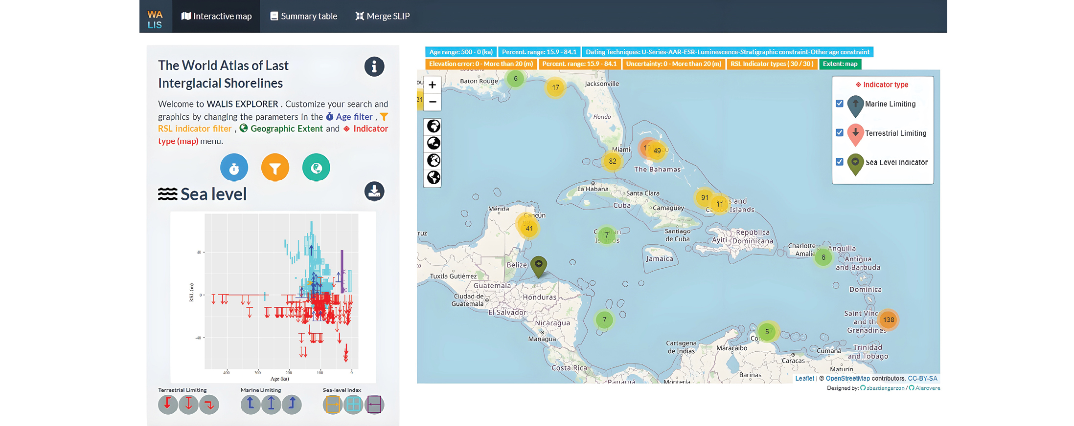
The second achievement of our work was the creation of a platform to query and analyze the data already included in WALIS. This work was done through an R Shiny App querying a simplified version of the WALIS database (i.e. including only the essential fields related to indicator type, paleo sea level and dating information). The app is currently in its 2.0 version. The code to run the app offline is available from Garzón and Rovere (2022), and the app is also accessible online at this link: warmcoasts.shinyapps.io/WALIS_Visualization/. The application is divided into three pages, which the user can navigate. On the first page, it is possible to filter the data by geographic selection, age, elevation, or indicator type. On the second page, the app allows the previously selected data to be downloaded in .csv format. Finally, on the third page, the app allows further fine-tuning of the data query by excluding specific index points and calculating an age/sea-level probability density graph using a Monte Carlo approach.
The results briefly described above represent a fundamental stepping stone towards increasing the wide availability and usability of paleo sea-level data. Our data and code are fully open access. Bug reports and suggestions on how to improve the current products and forks to the GitHub repositories linked to the published code versions are also welcome.
ACKNOWLEDGEMENTS
Thanks to the European Research Council under the European Union’s Horizon 2020 research and innovation programme (grant agreement No. 802414) for funding the World Atlas of Last Interglacial Shorelines database WALIS (Rovere et al. 2022).
affiliations
1Department for Environmental Sciences, Informatics and Statistics, Ca’ Foscari University of Venice, Italy
2MARUM, Center for Marine Environmental Sciences, University of Bremen, Germany
3Laboratory of Geo-information Science and Remote
Sensing, Wageningen University & Research,
The Netherlands
4Environmental Law Institute, Washington DC, USA
5Department of Earth Science, The University of Hong Kong, Hong Kong
contact
Alessio Rovere: alessio.rovere unive.it (alessio[dot]rovere[at]unive[dot]it)
references
Drechsel J et al. (2021) Quat Sci Rev 259: 106884
Düsterhus A et al. (2016) Clim Past 12: 911-921
Garzón S, Rovere A (2022) WALIS visualization interface. Zenodo
Khan NS et al. (2019) Quat Sci Rev 220: 359-371
Rovere A, Dutton A (2021) PAGES Mag 29: 18-20
Rovere A et al. (2022) WALIS - The World Atlas of Last Interglacial Shorelines (Version 1.0). Zenodo

