A major paleoearthquake in central Canada interpreted from early postglacial subaqueous mass transport deposits
Brooks G.R.![]()
Stratigraphic and chronologic evidence reveal that widespread mass transport deposits (MTDs) accumulated synchronously within glacial Lake Barlow-Ojibway, central Canada. This MTD signature is best explained by a strong paleoearthquake of Mw ~7.3.
Regional context
Glacial Lake Barlow-Ojibway formed against the Laurentide Ice Sheet as it retreated northwards through western Quebec-northeastern Ontario, central Canada (Veillette 1994; Vincent et al. 1979). The lake persisted between about 11.0–8.2 kyr cal BP (Brouard et al. 2021; Dyke 2004), then drained catastrophically northwards into the Hudson Bay basin. Extensive glaciolacustrine sediments containing interbedded subaqueous landslide deposits (or mass transport deposits [MTDs]) accumulated within the lake and now underlie large areas of the former basin, including the beds of modern lakes. A paleoseismic investigation into the spatial distribution and age of such buried MTDs can recognize a regional signature of similarly aged MTDs that may be evidence of a major paleoearthquake, as summarized in this article.
Recognizing a regional MTD signature
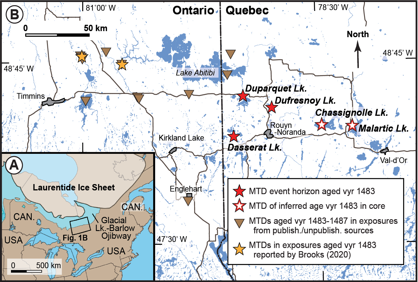
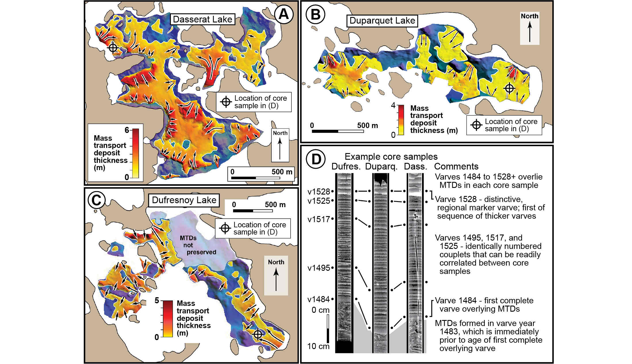
To recognize the presence of a possible regional MTD signature in the Barlow-Ojibway basin, sets of "event horizon" maps were compiled using data from sub-bottom geophysical surveys at Dasserat, Duparquet, and Dufresnoy lakes (Fig. 1b). An individual event horizon map depicts the MTD(s) that occur at a specific stratigraphic level within a study area (e.g. Fig. 2a). Each map may contain a single, or multiple, MTD(s), depending on the deposits present at that stratigraphic level. Where two or more MTDs are depicted on a given map, the deposits are the same age. In total, 26 event horizon maps were compiled for the Dasserat (five), Duparquet (13), and Dufresnoy (eight) study areas, which are located 24 to 38 km apart (Fig. 1b; Brooks 2016; 2018).
 |
|
Figure 1: (A) Map showing the study area and regional environmental setting at 8.98 kyr cal BP (modified from Dyke 2004). (B) Map showing the distribution of sites comprising the vyr 1483 MTD signature in western Quebec-northeastern Ontario. Modified from Brooks (2020). |
To establish chronology for the event horizon maps, core samples were collected targeting sequences of glaciolacustrine sediments overlying the MTDs depicted on the individual maps (see Brooks 2016, 2018). The recovered glaciolacustrine sediments were composed of clastic rhythmic couplets, interpreted to be annual varves, which are widespread throughout the Barlow-Ojibway basin (Antevs 1925). A composite varve series was compiled for each study area by correlating overlapping varve thickness patterns between the core sampling sites. Each composite series was then correlated to a published regional series of varve thickness data compiled for the Barlow-Ojibway basin (see Breckenridge et al. 2012). Known as the Timiskaming varve series, the regional series consists of about 2100 varves that are numbered individually from varve (v) v1 (oldest) to ~v2100 (youngest). Applying the regional series numbering to the three study areas, varves provided common numbering for stratigraphically equivalent (or nearly equivalent) couplets, as exemplified in figure 2d. Since each varve is an annual deposit, the Timiskaming series also represents a high-resolution, relative chronology consisting of varve years that are numbered identically to the varve deposits, e.g. v1528 is the couplet deposited in varve year (vyr) 1528. The varve year numbering does not correspond to BP years, but the ~2100 vyr range falls within the 11.0–8.2 kyr cal BP duration of the glacial lake.
The varve age of the MTD(s) on each event horizon map is interpreted to be the varve year immediately prior to the number of the first complete couplet in the varve sequence overlying the MTD (see Fig. 2d). This first overlying varve represents fully restored varve sedimentation during the year following the MTD, which would have interrupted varve formation. Remarkably, the varve chronology revealed that the event horizon map containing the greatest number of, and most widely distributed, MTDs within each study area have identical ages of vyr 1483 (equivalent to about 9.1 kyr cal BP; Fig. 2a–c; Brooks 2018). The high precision of the interpreted vyr 1483 ages is apparent in figure 2d from the consistency of the varve numbering and thickness patterns within the v1484–v1528 sequence between the study areas. Key to this precision is the identification of v1528, a distinctive, easily recognized, marker varve in the Barlow-Ojibway basin (see Breckenridge et al. 2012). The MTDs on the three vyr 1483 event horizon maps are clearly part of a widespread MTD signature.
Investigation at Chassignolle and Malartic lakes extended the vyr 1483 signature further to the east (Fig. 1b). Here, coring targeted MTDs overlain by varves with reflection patterns in sub-bottom geophysical profiles that were similar to the reflection patterns overlying the vyr 1483 MTDs in the Dasserat, Duparquet, and Dufresnoy study areas. The interpreted varve ages for the respective MTDs in sediment cores from Chassignolle and Malartic lakes, however, are vyr 1485 rather than vyr 1483. Brooks (2020) attributed this slight age difference to varve counting that did not recognize two thin rhythmic couplets between the MTDs and v1528 in these sediment cores. He thus inferred that the vyr 1483 MTD signature is present in Chassignolle and Malartic lakes.
 |
|
Figure 2: Event horizon maps showing the vyr 1483 MTDs at the Dasserat (A), Duparquet (B), and Dufresnoy (C) study areas. (D) CT-scan radiograph images of core samples showing the varve sequences overlying the vyr 1483 MTDs at each study area. Modified from Brooks (2020). |
The signature was extended further to the west and southwest of Dasserat, Duparquet, and Dufresnoy lakes using published and unpublished records of varve sequences that overlie MTDs in subaerial outcrops of glaciolacustrine deposits (Fig. 1b). The varve numbering in these sequences revealed three sites with MTDs aged vyr 1483 and nine sites with MTDs aged between vyr 1484–1487 (Brooks 2020). To assess whether the latter differences were significant or not, outcrops were examined at two locations near sites where the published/unpublished logs suggest slightly younger MTD ages (Fig. 1b). At both exposures, careful varve counting relative to v1528, the regional marker varve, confirmed the vyr 1483 ages for the MTDs (Brooks 2020). This indicates that the slightly younger ages probably reflect differences in varve counting over what are deemed to be vyr 1483 MTDs. Overall, collectively, there is strong stratigraphic and chronologic evidence for a regional MTD signature that extends across at least 220 km of the glacial Lake Barlow-Ojibway basin (Fig. 1b) and which formed in vyr 1483 (about 9.1 kyr cal BP).
Origin of the MTD signature
Shaking from a significant paleoearthquake can readily explain the triggering of the vyr 1483 regional MTD signature, but plausible aseismic mechanisms also need to be considered. Brooks (2016, 2018, 2020) assessed aseismic mechanisms relative to a deep water, distal glaciolacustrine depositional environment consistent with the regional setting at that time (Fig. 1a). Candidate aseismic mechanisms were: i) overloading-oversteepening of slopes from high glaciolacustrine sedimentation rates, ii) grounding of icebergs, iii) wave actions during major storms on the lake, and iv) rapid, major drawdown of lake level. The first three mechanisms could certainly trigger failures, but none seems likely to generate them over the scale of the regional MTD signature within a single varve year (see Brooks 2016, 2020). A rapid, major drawdown event resulting in the extensive exposure of lake-bottom sediments, however, is a viable mechanism. This would generate high pore-water pressures within the poorly draining silt and clay glaciolacustrine sediments, undoubtedly triggering widespread failures across the glacial lake basin (Brooks 2020).
Godbout et al. (2020) identified two drawdowns of glacial Lake Barlow-Ojibway that represent late stage (between vyr 1877–2065) and final (vyr ~2129) drainage events of the lake. Both are interpreted from anomalous sediment textures and structures within, or immediately overlying, the varve sequence. In contrast, Brooks (2020) reported there is nothing remarkable about the thickness and texture of v1483 relative to the immediately under- and overlying varves that might indicate a drainage event. This lack of evidence thus excludes the drawdown mechanism as an explanation for the regional MTD signature.
By a process of elimination, the regional MTD signature in vyr 1483, or about 9.1 kyr cal BP, was hypothesized to be best explained by a strong paleoearthquake. Brooks (2020) estimated a minimum magnitude of Mw ~7.3 for this paleoearthquake, using a relationship between the area affected by earthquake-triggered landsliding and moment magnitude from Keefer (2002). Fundamental to establishing this paleoearthquake hypothesis is the high-precision varve chronology used to define the regional MTD signature, and which indicates that the signature formed within a single varve year.
ACKNOWLEDGEMENTS
Nuclear Waste Management Organization and Natural Resources Canada provided support for this research. This article represents NRCan contribution 20230247.
Affiliation
Geological Survey of Canada, Natural Resources Canada, Ottawa, Canada
contact
Gregory R. Brooks: greg.brooks nrcan-rncan.gc.ca
references
Antevs E (1925) Geol Surv Can Memoir 146, 142 pp
Breckenridge A et al. (2012) Quat Int 260: 43-54
Brooks GR (2016) Quat Res 86: 184-199
Brooks GR (2018) Sedimentology 65: 2439-2467
Brooks GR (2020) Quat Sci Rev 234: 106250
Brouard E et al. (2021) Quat Sci Rev 274: 107269
Dyke AS (2004) In: Ehlers J et al. (Eds) Developments in Quaternary Science 2: 373-424
Godbout PM et al. (2020) Quat Sci Rev 238: 106327
Keefer DK (2002) Sur Geophys 23: 473-510