Paleoseismic studies reveal the high seismic hazard potential of the Matano fault, Sulawesi, Indonesia
Patria A.![]() and Daryono M.R.
and Daryono M.R.![]()
The Matano Fault in Sulawesi, Indonesia, has remained unruptured for the last two centuries. However, paleoseismic investigations reveal a seismic hazard potential as large as that of the Mw 7.5 Palu earthquake in 2018 CE.
Background
Sulawesi, Indonesia, is an actively deforming region with intense seismicity due to the rapid convergence between the Eurasian, Pacific, and Australian plates (Fig. 1; Bock et al. 2003). The most recent surface-faulting event was the 2018 CE Mw 7.5 Palu earthquake that ruptured a ~170 km long portion of the Palu-Koro Fault in central Sulawesi, and caused massive destruction in Palu City and surrounding areas (Natawidjaja et al. 2021). A question has been raised about the seismic hazard of Sulawesi. Where are the next large earthquakes (Mw ≥7) likely to occur?
The Matano Fault is the southeastern extension of the Palu-Koro Fault. This fault has the considerable capability of producing large earthquakes (Center of National Earthquake Study (PuSGeN) 2017; Watkinson and Hall 2017). The fact that no historical report about large earthquakes on the fault is available indicates that the fault has remained unruptured for at least two centuries, and has been storing enough slip (energy) to be released for the next surface-rupturing earthquakes. To date, the largest modern seismicity on the Matano Fault was the 2011 CE Mw 6.1 earthquake near Lake Matano.
The left-lateral motion in eastern Indonesia, due to the fast westward motion of the Pacific plate relative to the Australian plate, is accommodated by the Palu-Koro and Matano faults in Sulawesi (Fig. 1). The Palu-Koro Fault slips at ~ 40 mm/yr (Socquet et al. 2006) while the Matano Fault moves at ~20 mm/yr (Khairi et al. 2020; Walpersdorf et al. 1998). These motion rates are comparable to the San Andreas Fault’s motion in the US, at ~30 mm/yr (Sieh and Jahns 1984). However, limited fundamental geological information on the Matano Fault, such as history of large seismic events, the potential maximum magnitude and the extent of surface-rupturing earthquakes, has been a significant barrier to evaluating the seismic hazard posed by the fault.
 |
|
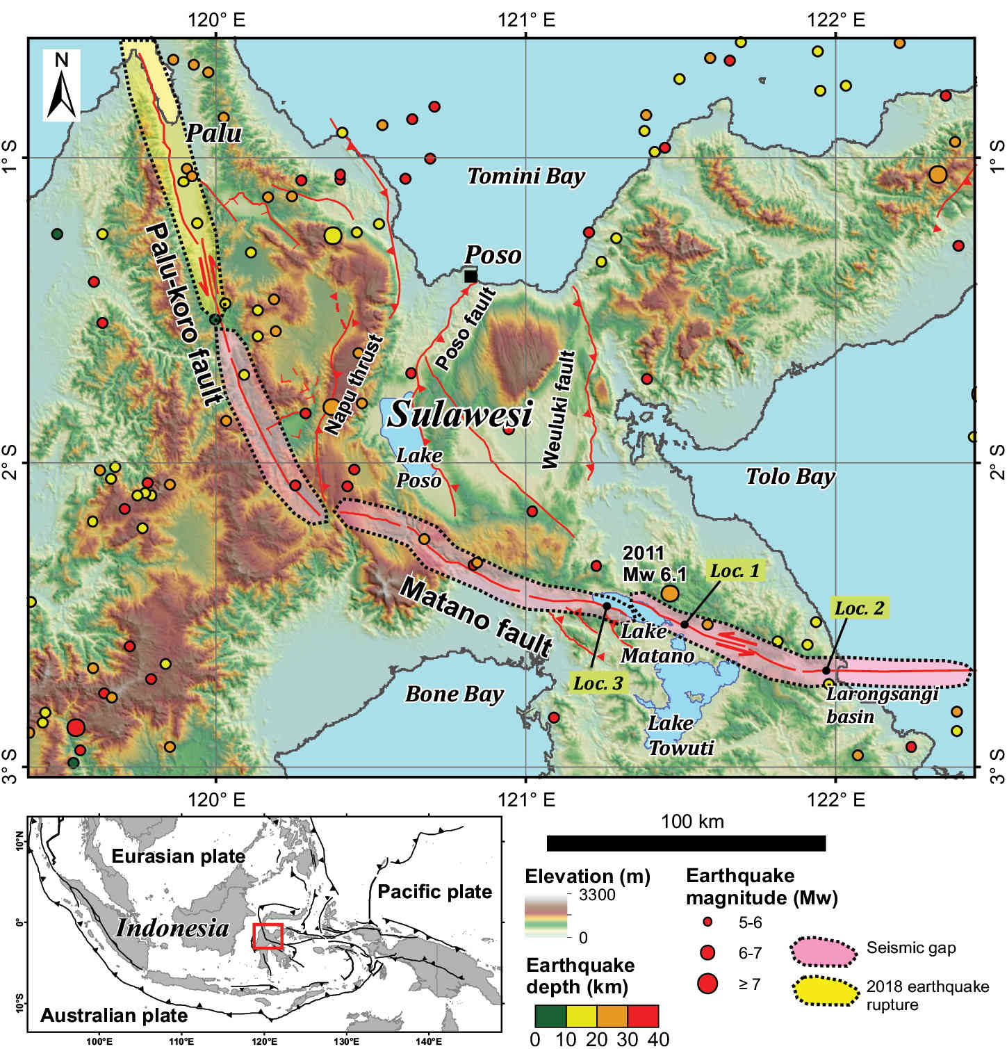
Figure 1: Active fault map of central Sulawesi with modern seismicity (modified from Center of National Earthquake Study (PuSGeN, 2017). Locs. 1, 2, and 3 indicate the locations of fault ruptures observed by Daryono et al. (2021), the paleoseimic trench by Patria et al. (2023), and submerged iron production settlement at Lake Matano (Adhityatama et al. 2022), respectively. Note that the 2018 Mw 7.5 earthquake’s rupture still extends further north, beyond the map. |
Recent paleoseismic investigations that examine the relationship between stratigraphy and fault structures at the shallow subsurface have revealed the seismic behaviors of the Matano Fault, which is helpful to better mitigate seismic hazards for the areas near the fault (i.e. Daryono et al. 2021; Patria et al. 2023).
Seismic behaviors of the Matano Fault
The Matano Fault traverses central Sulawesi for ~190 km in a NW-SE direction and consists of six geometric segments separated by structural discontinuities (Fig. 1). The first evidence of surface-rupturing earthquakes in the past on the Matano Fault was revealed by Daryono et al. (2021), who found evidence of two seismic events dated to ~4200–3000 BCE on the fault segment east of Lake Matano (Loc. 1 in Fig. 1). Geomorphic reconstruction by Daryono et al. (2021) also indicated a total left-lateral offset of ~400 m due to the fault motion. The Matano Fault has repeteadly moved and produced Mw 7-class earthquakes, rupturing multi-fault segments, similar to the 2018 Mw 7.5 Palu earthquake (Daryono et al. 2021).
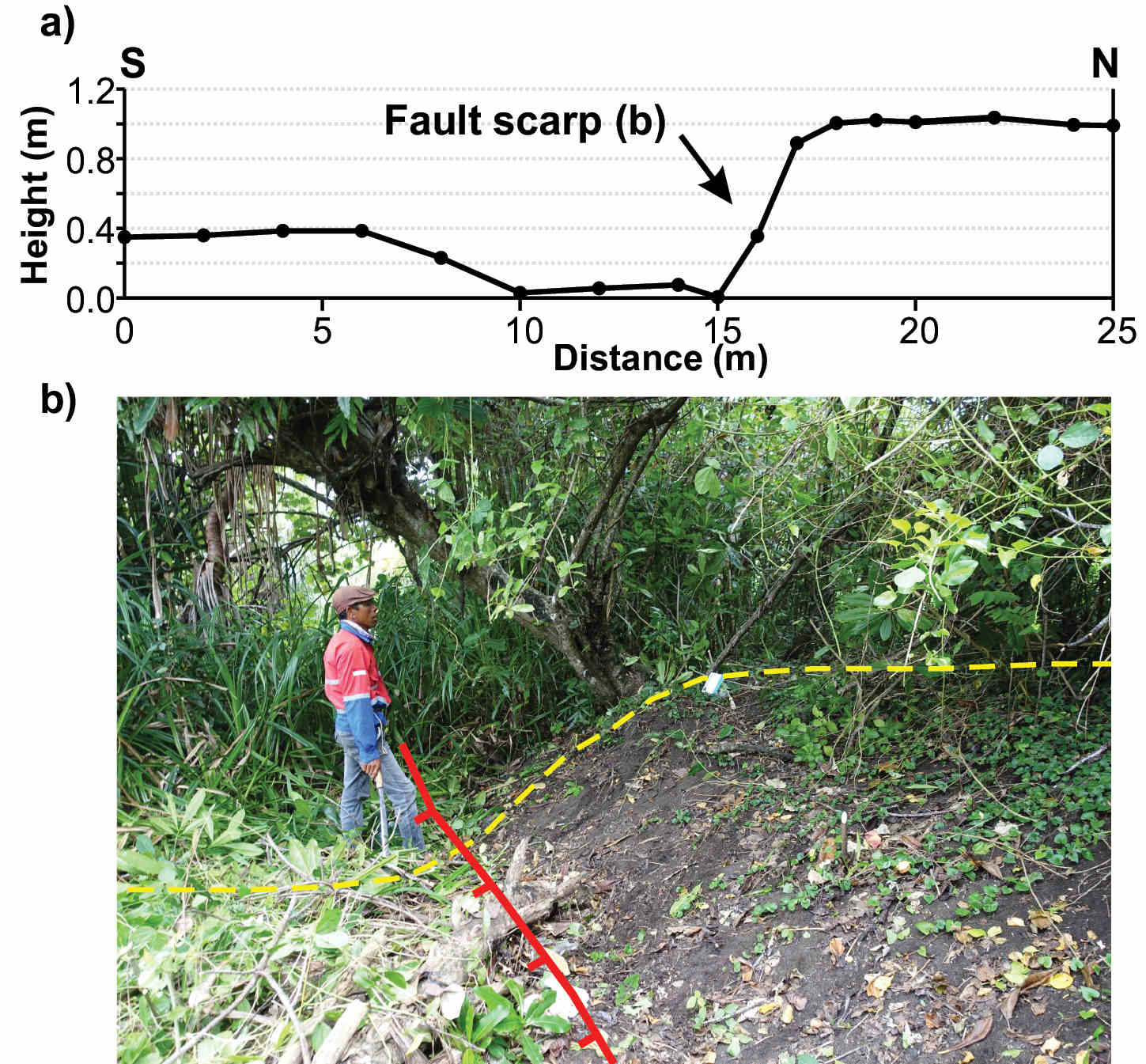
A recent study by Patria et al. (2023) investigated the easternmost portion where the fault runs within a quaternary basin, called the Larongsangi basin (Loc. 2 in Fig. 1). Based on tectonic geomorphic interpretation using a high-resolution digital elevation model (DEM) generated from the LiDaR (Light Detection and Ranging) data, they mapped geomorphic features and surface traces of the Matano Fault. Along the fault, the smallest left-lateral offset was on the beach ridge, ~7 m, accompanied by a 1 m high fault scarp (Fig. 2). These features were interpreted as a result of a single earthquake because they were found on the youngest geomorphic surface.
Based on the scaling relations by Wells and Coppersmith (1994), the 7 m offset was likely caused by a Mw 7.4 earthquake rupturing a 110 km long fault. A paleoseismic trenching on a 2 m high fault scarp revealed the history of surface-rupturing earthquakes (Loc. 2 in Fig. 1). Using the trench observation and radiocarbon dating, the most recent surface-rupturing earthquake was dated between 1432–1819 CE. The penultimate and antepenultimate surface-rupturing earthquakes were constrained between 1411–1451 CE and 981–1355 CE, respectively. There were two other older earthquakes which occurred prior to 1000 CE. Therefore, based on the timing of these earthquakes, the reccurence interval was estimated at 335 ± 135 years.
 |
|
Figure 2: (A) Topographic profile and (B) photograph of the smallest fault scarp cutting the youngest beach ridge on the eastern Matano Fault. This geomorphic feature was interpreted as a result of a single surface-rupturing earthquake. |
Seismic hazard evaluation
Lake Matano in the center of the Matano fault occupies a 6 km wide stepover between two fault segments (Fig. 1). According to Wesnousky (2006), stepovers wider than 4 km behave as earthquake-rupture terminations for large earthquakes. Patria et al. (2023) postulated that the surface-rupturing earthquake observed in the paleoseismic trench (Loc. 2 in Fig. 1) spanned ~110 km from Lake Matano to the offshore east of the Larongsangi basin (Fig. 1). The absence of a surface-faulting event on the Matano Fault in the last two centuries suggests that the fault may have formed two seismic gaps, separated by Lake Matano, which are potential locations for the next surface-rupturing earthquakes.
Large seismic events on the Matano Fault could be devastating. Within Lake Matano, an iron production village dating back to the eighth century had submerged at a depth of 3–15 m (Loc. 3 in Fig. 1) (Adhityatama et al. 2022). This iron production site’s subsidence could have been caused by catastrophic events, possibly repeated large earthquakes on the Matano Fault. For the eastern portion of the Matano Fault, the elapsed time since the most recent surface-faulting event is more than 200 years, exceeding the minimum calculated recurrence interval. Thus, the next surface-rupturing earthquake is plausibly due for the eastern portion. In addition to the shaking and ground deformation, large earthquakes on the Matano Fault, particularly the eastern portion, could cause a submarine-landslide tsunami.
Structural interpretion by Titu-Eki and Hall (2020), based on high-resolution multibeam bathymetry, indicated the existence of large submarine landslides at continental slope near the fault. Such landslides could have been triggered by strong shaking, and may have generated tsunamis.
Summary
Paleoseismic studies on the Matano Fault have revealed the history of large seismic events on the fault and the magnitude and extent of surface-rupturing earthquakes, which are helpful for seismic-hazard assessment. The Matano Fault forms two seismic gaps that could produce the next large earthquakes. Studies on the Matano Fault demonstrated the benefits of paleoseismic investigation to understand the seismic hazard posed by the fault.
In Indonesia, many active faults have been identified, but geological information on these faults is still lacking. Therefore, more paleoseismic studies are required to understand the seismic behaviors and evaluate the seismic hazard of these active faults. Subaqueous paleoseismic investigations on Lake Matano may also be useful in providing a longer and more complete record of earthquakes than the conventional paleoseismic method, as demonstrated by Tournier et al. (2023) in Lake Towuti, southeast of Lake Matano.
ACKNOWLEDGEMENTS
We thank Danny H. Natawidjaja, Mohammad Heidarzadeh, Hiroyuki Tsutsumi, Muhammad Hanif and Anggraini R. Puji for the discussion of the research on the Matano Fault.
affiliation
Research Center for Geological Disaster, National Research and Innovation Agency (BRIN), Bandung, Indonesia
contact
Adi Patria: adi.patria brin.go.id
REFERENCES
Adhityatama S et al. (2022) Archaeol Res Asia 29: 100335
Bock Y et al. (2003) J Geophys Res 108: 2367
Daryono MR et al. (2021) IOP Conf Ser Earth Environ Sci 873: 12053
Khairi A et al. (2020) J Geod Undip 9: 32-42 (in Indonesian with English abstract)
Natawidjaja DH et al. (2021) Geophys J Int 224: 985-1002
Patria A et al. (2023) Tectonophysics 852: 229762
Sieh KE, Jahns RH (1984) GSA Bull 95: 883-896
Socquet A et al. (2006) J Geophys Res 111: B08409
Titu-Eki A, Hall R (2020) Indones J Geosci 7: 291-303
Tournier N et al. (2023) Quat Sci Rev 305: 108015
Walpersdorf A et al. (1998) Geophys J Int 135: 351-361
Watkinson IA, Hall R (2017) Geol Soc Spec Publ 441: 71-120
Wells DL, Coppersmith KJ (1994) Bull Seismol Soc Am 84: 974–1002