Combining geological and archaeological evidence to infer the recent tectonics of the Montagne du Vuache Fault, Jura Mountains, France
Lallemand T.![]() 1, Quiquerez A.
1, Quiquerez A.![]() 2, Audin L.
2, Audin L.![]() 1, Baize S.
1, Baize S.![]() 3, Grebot R.2 and Mathey M.
3, Grebot R.2 and Mathey M.![]() 3
3
A multidisciplinary study combining structural geology, geomorphology and archaeoseismology on a Gallo-Roman site in the Jura Mountains shows potential evidence of recent tectonic deformation along the northern Montagne du Vuache Fault. These new findings question the role of past earthquakes in the site abandonment.
Seismotectonic background of the Montagne du Vuache Fault (MVF)
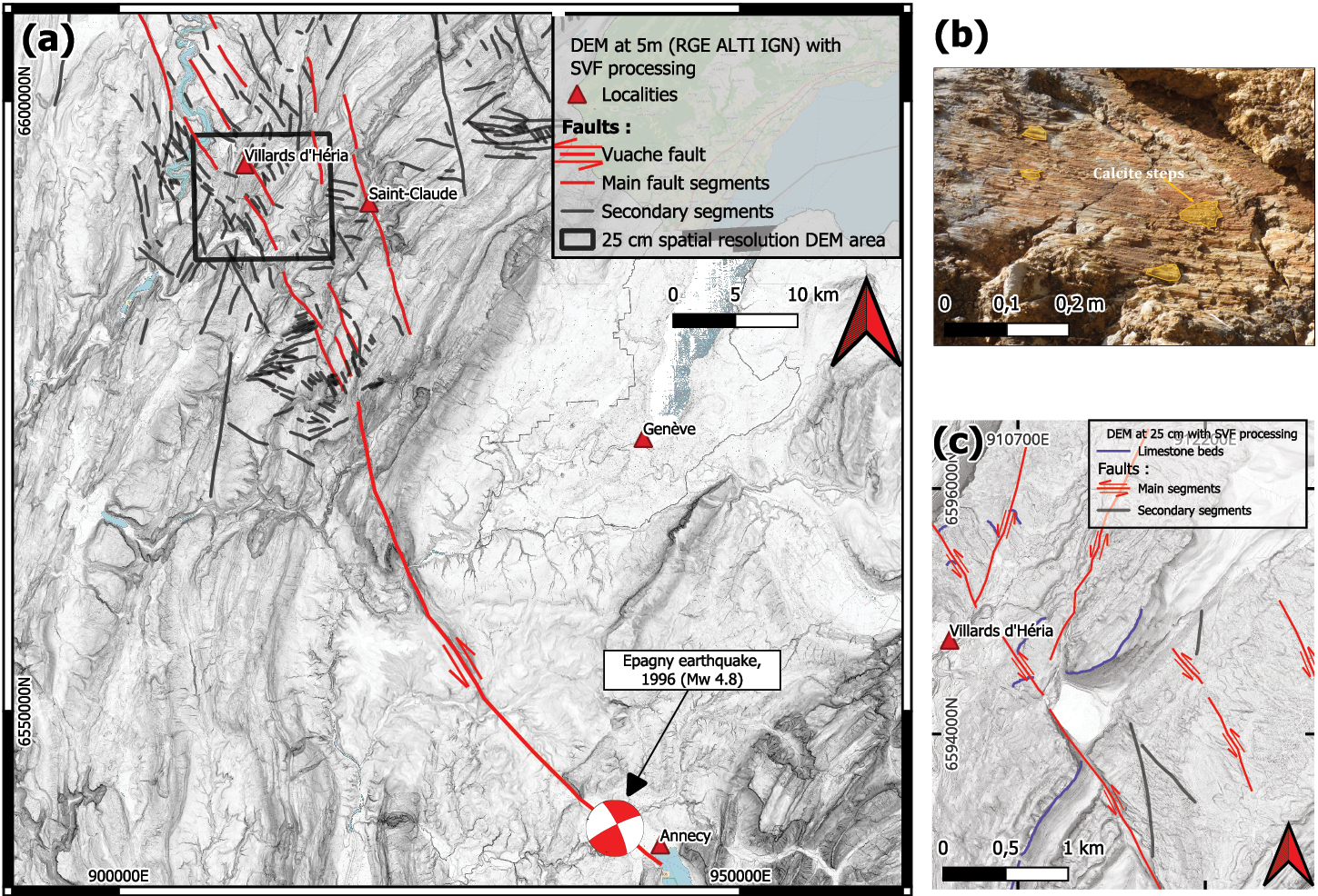
The MVF is a major fault system extending over ~80 km from the edge of the Alpine range to the Jura Mountains (calcareous rocks), through the southernmost Swiss Molasse basin (sandstones and siltstones, Baize et al. 2011; Fig. 1). The recent tectonics of the MVF have been studied in its southeastern part, following the damaging Epagny earthquake near Annecy (13 July 1996; moment magnitude [Mw] 4.8; Thouvenot et al. 1998; Courboulex et al. 1999; Fig. 1a).
While Quaternary left-lateral faulting has been confirmed there (e.g. displacement of small valleys, syn-depositional deformation, Baize et al. 2011; De La Taille 2015), these studies have not yet demonstrated the occurrence of surface-rupturing events during the last thousands of years. Tracking those surface-rupture events is crucial to defining the seismic hazard related to the fault. This can be achieved by dating deformed features, either on natural or anthropogenic objects.
As the fault extends northwestward into the Jura Mountains, it splits into multiple segments. In this area, the youngest evidence of fault activity at the surface relies on syntectonic mineralized calcites, the dating of which indicates a main phase of activity at around 10 Ma followed by a reactivation phase at ~5 Ma (Smeraglia et al. 2021).
 |
|
Figure 1: (A) Geomorphological imprint of the fault based on a 5 m spatial resolution DEM, and on a 25 cm spatial resolution DEM in the boxed area. (B) Calcite steps observed on a fault plane, here with left-lateral strike-slip kinematics. (C) Example of left-lateral offset across limestones along one of the main fault segments. Projected coordinate system: EPSG 2154, RGF93 / LAMBERT 93. |
What’s new along the northern section of the MVF? A morphotectonic and structural perspective
We analyzed the geomorphological imprint of the fault, based on a regional 5 m spatial resolution Digital Elevation Model (DEM), as well as a 25 cm spatial resolution DEM around the Villards d’Héria area (black square in Fig. 1a), to identify geomorphic markers (lineaments, surface fractures, watercourses, limestone beds, ridge lines, valley bottoms, and geological units), revealing horizontal displacements.
Along the MVF trace running from Annecy to the Jura Mountains, we detected 342 lineaments (Fig. 1a). About 45% of them were identified as fault segments, showing signs of kinematics, with 75% of them exhibiting left-lateral motion (red segments, Fig. 1a), predominantly in the NW-SE direction. Segments with other orientations and kinematics may be old inherited faults, or secondary faults conjugated to the main faults (black segments, Fig. 1a).
As suggested by the potentially active fault map of France (Jomard et al. 2017), the MVF signature in morphology splits as it reaches the Jura mountain range, with one section crossing the area of interest around Villards d’Héria, suggesting that the distribution of the deformation is controlled by surface lithology. Where "hard" rocks (limestones) are close to the surface, the subparallel segments are numerous (Jura domain, NW part of the fault). Conversely, fault segmentation is limited, and the geometry appears rather continuous where "soft" rocks (molasse) are dominant (Savoy area, southeastern part of the fault). A splay fault structure can thus be observed in our study area, which is located at the northwestern end of the MVF (Fig. 1a). Numerous fault segments can be observed in the morphology there (Fig. 1a). Field investigations confirmed numerous NW-SE fault planes with left-lateral, strike-slip kinematics, evidenced by calcite steps (Fig. 1b). When associated with their conjugate faults (right-lateral, NE-SW), the paleostresses accommodated by these faults can be well constrained.
A preliminary slip rate was estimated from limestone bed offsets (Fig. 1c), based on the analysis of the lineaments detected on the DEM. The displacement classification shows that the most represented classes occur between 200 m and 1000 m of cumulative horizontal displacement. Smeraglia et al. (2021) proposed that the first phase of deformation occurred at 10 Ma (onset of Jura NW-SE shortening), and that a second phase occurred at around 5 Ma, with corresponding slip rates between 0.02-0.1 mm/yr and 0.04–0.2 mm/yr, respectively. These values fall in the lower range of the slip rates proposed by Baize et al. (2011) based on regional correlations.
The Gallo-Roman site and the potential for archaeo-earthquakes
The sanctuary area of Villards d’Héria provides the ideal archaeological context for studying the cause-and-effect relationship between a faulted bedrock and deformation of archaeological remains. The sanctuaries are spread over two sites (Fig. 1c). The upper site, near Lake d’Antre (802 m asl) is bounded by the Antre Fault. The lower site, "Pont-des-Arches", in the Héria Valley (712 m asl) consists of a worship area and bathing facilities. The two sites are connected by karstic conduits (Nouvel et al. 2018), whose flow is driven by a dense fracture network. Excavations have provided evidence of continuous occupation from the first century BCE until the last decades of the third century.
 |
|
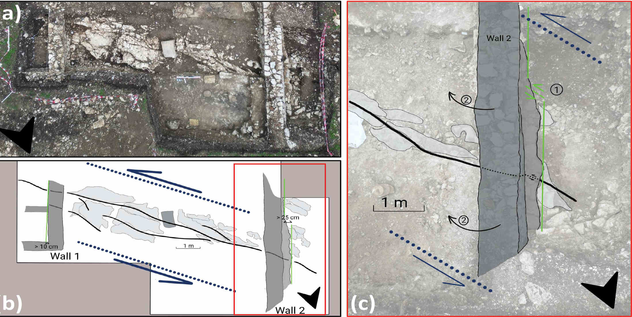
Figure 2: Area of archaeoseismological investigations. (A) Zenithal view of deformed walls, and (B) structural diagram of the faulted zone, and impacted infrastructures. (C) Focus (red box on (B)) on Wall 2 displaying two phases of damage: a sinistral offset at the base (phase 1), and a tilting of the structure in the upper part (phase 2). |
In 2021, while conducting excavations at the lower site, unexpected signs of damage and disorders were identified on the archaeological remains, specifically on walls (Wall 1 and Wall 2, Fig. 2). Further exploratory field surveys in 2023 revealed that the archaeological deformation features were collocated with left-lateral kinematics in the bedrock. The facing of the two walls displays obvious misalignments, visible in both plan and zenithal views (Fig. 2b). At this point, Wall 1 exhibits a minimum left-lateral offset of 10 cm, taking the wall orientation without deformation as reference. Deformation features on Wall 2 potentially imply two phases of deformation. The base of the wall is left-laterally shifted with an offset of 25 cm (phase 1), assuming an initial straight shape when it was built (indicated by the green line, Fig. 2c). Some of the blocks are broken, and a mortar was used to reinforce this part of the wall, which could have been used then as a foundation of the upper wall. Later, this latter wall was tilted (phase 2), dipping 70° to the east (Fig. 2c). All the Roman remains are sealed by a backfill layer, from the early third century. The disorders observed on the walls, and the geological deformation features observed in the bedrock, are consistent with each other and with regional observations. The sinistral displacements observed on the walls could be the result of one or more ruptures during an earthquake(s) on a segment of MVF faults that needs to be further investigated.
Quantifying deformation through 3D reconstruction of the archaeological remains
At locations where the remains are well preserved, we plan to quantify deformations at a subcentimeter and millimeter scale on geological and archaeological markers through a detailed analysis of ortho-images and a high-resolution Digital Surface Model. This approach will facilitate the systematic examination of disorders, linear and/or angular deformations, and their comparison, by juxtaposing surveys a few meters apart. We also need to check the kinematic consistency of different archaeological markers at the archaeological site scale, to confirm the surface-rupture hypothesis.
Paleoseismological investigation
To better assess the tectonic history of the MVF, we intend to conduct a statistical analysis of striation orientations, coupled to dating of kinematic markers (U-Pb or U-Th, depending on their age). In addition, to enrich the timing of surface-rupturing events, we will perform a twofold paleoseismological investigation. We will focus on: 1) examining the stratigraphic records in the lacustrine sediments of Lake d’Antre, which is bounded by a MVF segment to the south (Fig. 1c); and 2) trenching across fault scarps to unearth rupture traces in the Holocene sediments and soils. These two datasets will, we hope, enable us to complete the chronology by going back in time, covering (partly) the Holocene. A set of sediment cores was already retrieved from the lake in June 2023, and their analysis is currently in progress. Concurrently, we will conduct Electric Resistivity Tomography profiles and explore prospective pits to locate suitable locations for paleoseismological trenches. We are also experimenting with subaqueous imaging techniques to investigate whether any tectonic deformation extends to the lake bottom.
The preliminary results reported here suggest the occurrence of tectonic events during Antiquity along the northern segments of the MVF. Surface-rupture faulting could have damaged and offset Gallo-roman remains, and strong local shaking during those events could have coevally damaged the constructions. If confirmed, the 20–30 cm wall offset could fit with the deformation characteristic of a shallow to very shallow moderate-magnitude earthquake, capable of causing strong shaking in the vicinity of the fault. From an archaeological point of view, this new hypothesis raises the question of the role of earthquakes on the site abandonment, whether due to the direct effects of earthquakes or their potential impact on hydrological flows in this karstic environment.
ACKNOWLEDGEMENTS
Special thanks to Vincent Bichet (Lab. Chrono-environnement, University of Franche-Comté, France) and his team for Lac d’Antre coring, and Philippe Roux and Jean Guillard (Lab. ISTerre University of Grenoble, and Lab. CARTELL, INRAE) for acoustic data acquired at Lac d’Antre. All these people are part of the ongoing effort developed to image the fault impacts on the upper site. We would also like to thank the Service Régional Archéologique of the Bourgogne-Franche Comté region, and the PCR "Villards d’Heria", for their financial support and the facilitation of this study.
affiliationS
1Université Grenoble Alpes, IRD, ISTerre, Grenoble, France
2ARTEHIS, Bourgogne University, France
3Institute for Radioprotection and Nuclear Safety, Fontenay aux Roses, France
contact
Théo Lallemand: theo.lallemand univ-grenoble-alpes.fr
references
Baize S et al. (2011) Bull Soc Géol Fr 182: 347-365
Courboulex F et al. (1999) Geophys J Int 139: 152-160
De La Taille C (2015) PhD thesis, Université Grenoble Alpes, 259 pp
Jomard H et al. (2017) Nat Hazards Eath Syst Sci 17: 1573-1584
Nouvel P et al. (2018) Rec Archeol 32: 103-114
Smeraglia L et al. (2021) Journal of Structural Geology 149: 104381