- Home
- Publications
- PAGES Magazine
- Diatoms In Earthquake and Tsunami Reconstruction Along The Chilean Subduction Zone: Valuable Proxies of a Paleoseismologist’s Toolkit
Diatoms in earthquake and tsunami reconstruction along the Chilean subduction zone: valuable proxies of a paleoseismologist’s toolkit
Hocking E.P., Garrett E. and Dura T.
Past Global Changes Magazine
32(1)
28-29
2024
Hocking E.P.![]() 1, Garrett E.
1, Garrett E.![]() 2 and Dura T.
2 and Dura T.![]() 3
3
Diatoms form a powerful proxy for reconstructing subduction-zone earthquake and tsunami histories. Using examples from Chile, we explore what diatoms have been able to tell us to ultimately help improve seismic hazard assessment, and highlight challenges and opportunities.
Globally, great subduction-zone earthquakes (moment magnitude [Mw] >8), and the tsunamis they generate, produce cascading hazards along coastlines. As the largest events can be so devastating, yet so infrequent, geologic records of earthquakes and tsunamis spanning centuries to millennia are required to understand subduction-zone behavior, and account for variability in earthquake size, rupture style and tsunami generation. Coastal sediments are excellent recorders of past earthquakes and tsunamis, and microfossils, such as diatoms (siliceous single-celled algae) found within them, have become one of the most commonly used proxies for reconstructing subduction-zone earthquake and tsunami histories (Dura et al. 2016).
Since the seminal work in the Pacific Northwest (e.g. Atwater 1987; Darienzo and Peterson 1990), the last 40 years have seen major advances in diatom-based reconstructions of earthquakes and tsunamis (Dura et al. 2016). Due to the close control of salinity on diatom distribution in intertidal environments, diatoms can be used to quantify vertical land-level change associated with great earthquakes, not only coseismically during earthquakes, but also potential pre- and post-earthquake deformation. Due to their resistance to degradation, diatoms have also been widely used to determine the provenance of tsunami sediments and changing flow conditions during tsunamis. Here we review three case studies from the Chilean coast that demonstrate how diatoms are being used to reconstruct earthquake and tsunami history on a highly active subduction zone, and highlight important lessons from our research.
Extending historical records
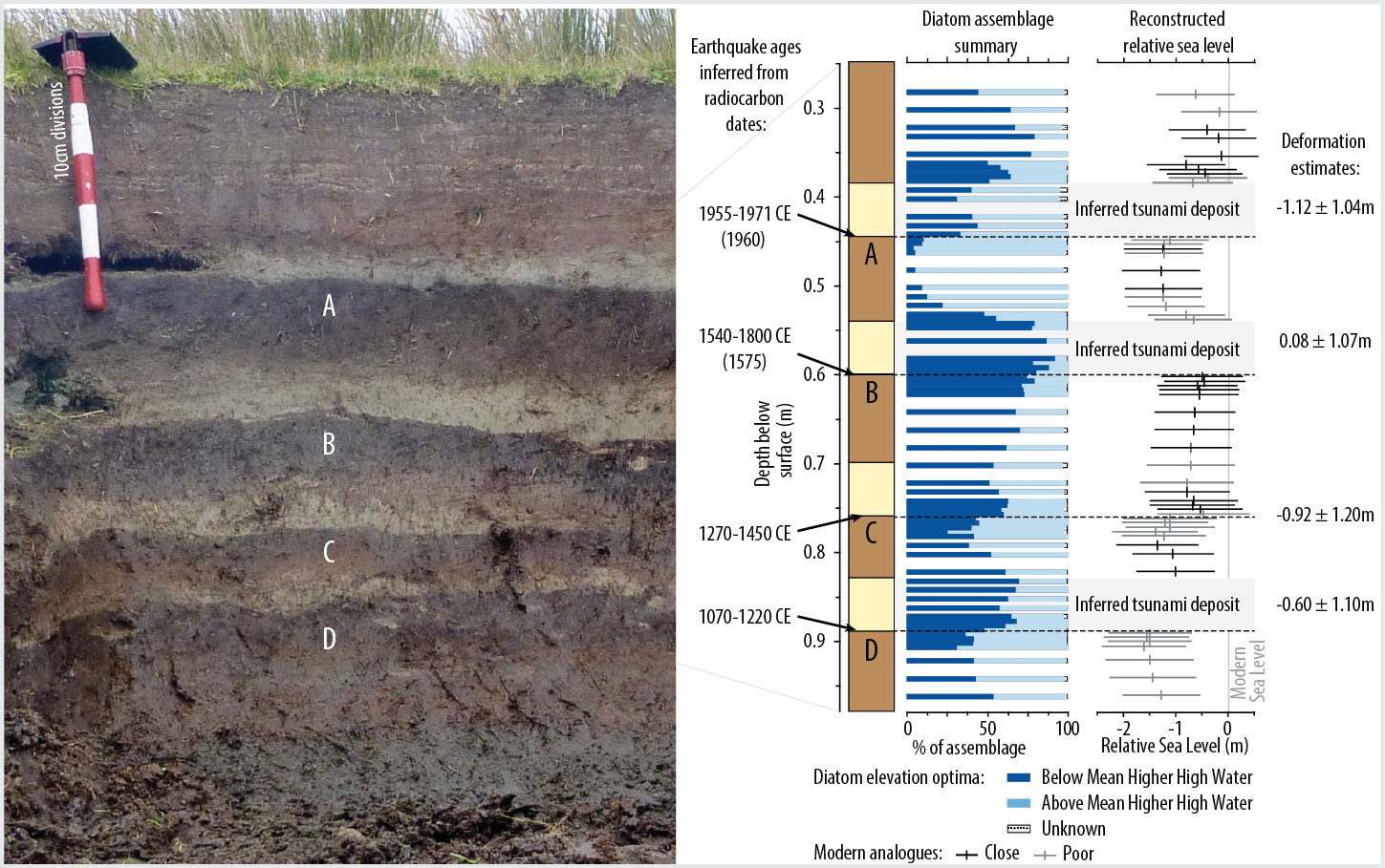
At Chucalén, south-central Chile, in the centre of the area which ruptured in the world’s largest instrumentally recorded earthquake, a Mw 9.5 event in 1960 CE, diatoms formed a powerful proxy for reconstructing coseismic land-level change that occurred in that event, and three earlier earthquakes during the last millennium (Fig. 1; Garrett et al. 2015). Diatom-based estimates of coseismic land-level change varied for the four earthquakes, ranging from meter-scale subsidence to slight uplift, suggesting variability in slip distribution. The length of the paleoseismic record at Chucalén is twice as long as the historical record, yet historically documented events in 1737 and 1837 CE are absent, critically suggesting variability in magnitudes and longer recurrence intervals between the largest events.
 |
|
Figure 1: A 1000-year record of great earthquakes at Chucalén, south-central Chile, shown by the laterally extensive buried soils (A–D) and diatoms. Figure modified from Garrett et al. (2015). |
The importance of utilizing multi-proxy geological and historical evidence in tandem
Historical records most commonly used in assessing seismic hazards are often too short to account for variability in earthquake size, rupture style and tsunami generation. Moreover, even where long written chronicles exist, failures in reporting, loss of documents in times of political instability or low-quality records may result in temporal gaps. Albeit with other limitations, geologic records are free from these problems. An example from Chaihuín, south-central Chile, close to the region of maximum slip in 1960 CE, demonstrates that it is imperative to supplement historical data with geologic records (Hocking et al. 2021).
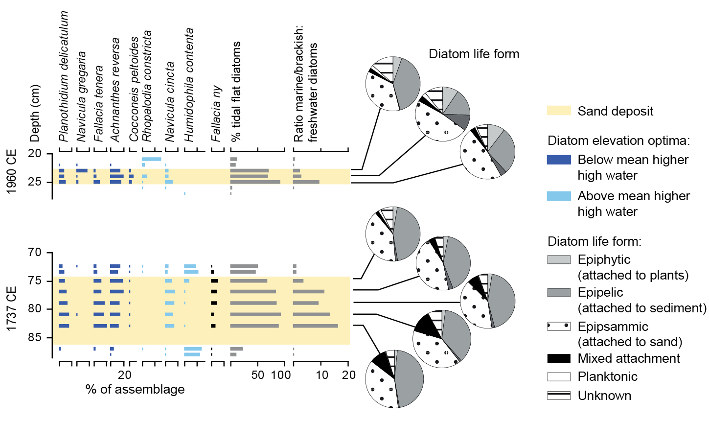
Previously, the lack of reports of tsunami inundation from the 1737 CE south-central Chile earthquake had been attributed to either civil unrest (which restricted Spanish settlers from occupying all, bar two, coastal towns) or a small tsunami due to deep-fault slip below land. However, using sedimentological and diatom analyses of tidal marsh sediments, we found evidence for a previously unreported, locally sourced tsunami consistent in age with this event. Diatoms confirmed coseismic subsidence of up to 0.9 m and abrupt marine inundation (Fig. 2). Coupled dislocation-tsunami models placed the causative fault slip mostly offshore, rather than below land, and our findings reduced the average recurrence interval of tsunami inundation derived from historical records alone.
The importance of millennial-scale geologic records in characterizing earthquake and tsunami hazards
In central Chile, historical accounts, and later instrumental measurements of a series of ~Mw 8.0–8.5 earthquakes and low (<4 m) tsunamis affecting the region in 1575, 1580, 1647, 1730, 1822, 1906 and 1985 CE, suggest a consistent recurrence interval of ~80 years for large earthquakes in the region. However, more recently uncovered historical clues from the 1730 CE event suggest this earthquake was larger (>Mw 9) than other earthquakes in the historical series, and produced a high tsunami that affected both the Chilean and Japanese coasts (Carvajal et al. 2017).
To dig deeper into the history of past >Mw 9 earthquakes along the densely populated central Chilean coast, Dura et al. (2015) conducted a stratigraphic, sedimentological and diatom investigation at Quintero. The study found evidence of six instances of high tsunami inundation and coastal uplift between 6200 and 3600 cal yrs BP, similar to that documented in 1730 CE. Diatom data were critical to supporting a marine source of the anomalous sand beds found in the stratigraphy, and for estimating uplift of ~0.5 m in each earthquake. The new tsunami and land-level change evidence shows a recurrence interval of ~500 years for outsized earthquakes and tsunamis in central Chile, and demonstrates that basing hazard assessments on only the most recent, but smaller, earthquakes and tsunamis overlooks the higher hazard posed by less frequent, but larger, events.
Challenges, opportunities and outlook
The examples demonstrate the value of utilizing diatoms in paleoseismology. However, as with any proxy, there remain challenges associated with their application. First, the above examples adopt transfer functions to quantify land-level change and, whilst such approaches enable more precise estimations of land-level change than earlier qualitative assessments, transfer functions have inherent assumptions and limitations. Diatom taxa in fossil sediments that are not present in our modern datasets (non-analogue situations) limit our ability to reconstruct past environmental change and accurately quantify land-level change.
Modern diatom dataset development is particularly challenging in places that have recently undergone coseismic subsidence, as the present-day tidal marsh may not provide a good modern analogue for the entire fossil sequence. Every effort must be made to improve modern diatom datasets by increasing numbers of samples across a range of coastal environments (capturing the full gradients of elevation, vegetation, substrates) to help mitigate against non-analogue situations (Hocking et al. 2017). Even then, reconstructions can be complicated by reworked microfossils, with certain taxa being prone to transport across the intertidal zone, and thus not being representative of their depositional environment (Hemphill-Haley 1995). In such instances, it may be necessary to exclude specific taxa when performing reconstructions. We emphasize that improved understanding of relationships between diatoms, salinity and substrates in the modern environment, as well as variations in the preservation and transport of specific taxa, will ensure more reliable identification of earthquakes and tsunamis in the geological record, and quantification of land-level change.
There is also the assumption when quantifying land-level change using a transfer function that sedimentary hiatuses do not occur post-earthquake. If sediment accumulation does not recommence before significant postseismic deformation occurs, the magnitude of coseismic deformation may be underestimated in transfer function reconstructions. Such delay in postseismic sediment accumulation was observed at two sites following the 2010 CE earthquake (Garrett et al. 2013), and the duration of such hiatuses are difficult to identify in fossil records.
Finally, as well as potentially underestimating the magnitude of deformation, geologic records may also underestimate the occurrence of Mw 7–8 earthquakes. Diatom analyses of tidal-marsh sediments within the rupture area of the 2016 CE Mw 7.6 Chiloé earthquake, south-central Chile, showed records of low-level (<0.1 m) land-level change were created for a limited period of time in limited parts of the tidal wetland, following the earthquake, with statistically significant changes observed between diatom assemblages pre- and immediately post-earthquake (Brader et al. 2021). However, the signal was temporary, and after nine months such assemblage changes were not preserved due to sedimentation processes (Brader et al. 2021). This highlights the limits of detection of this microfossil-based technique, and the potential underestimation of major, but not great, earthquakes in coastal paleoseismological records. This has important implications for estimating recurrence intervals in seismic hazard assessment, and further highlights the need to utilize multiple lines of evidence.
Diatoms are extremely useful for quantifying land-level change associated with subduction-zone earthquakes, and for determining tsunami provenance, ultimately helping to better understand recurrence intervals and variability in ruptures. However, their application must be seen as a key component of the paleoseismology toolkit; other proxies, as well as other approaches to reconstructing past earthquakes and tsunamis, such as the use of documentary evidence and modeling, are equally important. The power comes from combining approaches, and through such multidisciplinary research we can continue the remarkable advances in seismic-hazard assessment which have occurred over the last decade.
ACKNOWLEDGEMENTS
We acknowledge the contribution of co-authors to research presented here, including M. Cisternas, D. Melnick, D. Aedo, M. Carvajal, L. Ely, R. Wesson, I. Shennan, M. Brader, and funding from NERC, EU, and NSF.
affiliations
1Department of Geography and Environmental Sciences, Northumbria University, Newcastle-upon-Tyne, UK
2Department of Environment and Geography, University of York, UK
3Department of Geosciences, Virginia Tech, Blacksburg, USA
contact
Emma P. Hocking: emma.hocking northumbria.ac.uk
references
Atwater BF (1987) Science 236 (4804): 942-944
Brader M et al. (2021) J Quat Sci 36: 991-1002
Carvajal M et al. (2017) J Geophys Res: Sol Earth 122: 3648-3660
Darienzo ME, Peterson CD (1990) Tectonics 9: 1-22
Dura T et al. (2015) Quat Sci Rev 113: 93-111
Dura T et al. (2016) Earth-Sci Rev 152: 181-197
Garrett E et al. (2013) Quat Sci Rev 75: 11-21
Garrett E et al. (2015) Quat Sci Rev 113: 112-122
Hemphill-Haley E (1995) Geol Soc Am Bull 107: 367-378
