- Home
- Publications
- PAGES Magazine
- Earthquake-related Tsunami Archives Based On Sediments From Coastal Lagoons In The Lesser Antilles
Earthquake-related tsunami archives based on sediments from coastal lagoons in the Lesser Antilles
Fabbri S.C., Sabatier P., Paris R., Biguenet M., Falvard S., Feuillet N., St-Onge G. and Chaumillon E.
Past Global Changes Magazine
32(1)
34-35
2024
Fabbri S.C.![]() 1,2,3,4, Sabatier P.
1,2,3,4, Sabatier P.![]() 1, Paris R.
1, Paris R.![]() 5, Biguenet M.
5, Biguenet M.![]() 1,6 , Falvard S.
1,6 , Falvard S.![]() 5 , Feuillet N.
5 , Feuillet N.![]() 2 , St-Onge G.
2 , St-Onge G.![]() 3 and Chaumillon E.
3 and Chaumillon E.![]() 6
6
Sediment cores from two coastal lagoons in the Caribbean Sea provide evidence of regional and transatlantic paleotsunamis, alongside hurricane-related deposits. We employed sedimentological and geochemical methodologies, complemented by radiocarbon dating, to characterize these events spanning the past 3500 years.
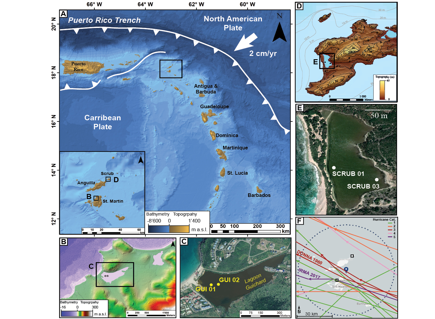
Around 12% of the global population, more than 898 million people in 2020, reside in low-lying coastal areas (≤10 m above sea level; Reimann et al. 2023) that are vulnerable to rising sea level and natural hazards such as hurricanes and tsunamis (MacManus et al. 2021). To prepare for these threats, we must determine the recurrence and intensity of such events beyond instrumental and historical records. Sediment deposits, serving as natural archives, provide vital insights into past tsunamis (e.g. Costa and Andrade 2020) and hurricanes (e.g. Wallace et al. 2021), which are essential for accurate hazard assessment. Coastal lagoon systems are an ideal event archive due to i) their excellent preservation potential as a natural sediment sink, ii) the presence of a sandy barrier separating the ocean from the sink, and acting as a filter for extreme-wave events (EWEs), and iii) their brackish origin, allowing the preservation of inland-mobilized material related to tsunami backwash. Our study investigated sediment cores in coastal lagoons on two Caribbean islands (Saint Martin and Scrub Island) in the Lesser Antilles (Fig. 1).
Earthquake, tsunami and hurricane hazards in the Lesser Antilles
The volcanic arc along the Lesser Antilles was formed by the subduction of the North American Plate under the Caribbean Plate at a rate of 2 cm/yr (Fig. 1a). Although this is one of the most seismically quiet subduction zones worldwide (Cordrie et al. 2022), the area was struck by notable moment magnitudes (Mw) 7 to 8 seismic events, affecting the Caribbean islands over the last 300 years (Feuillet et al. 2011). In addition to intense ground shaking during earthquakes, events in 1843, 1867, 1969, 1985, and 2004 CE generated tsunamis (Cordrie et al. 2022). Historical records and sediment analysis also suggest that the transatlantic Lisbon tsunami of 1755 CE reached the Lesser Antilles, causing tsunami wave heights of more than 2 m, as supported by numerical models (Roger et al. 2011). Apart from earthquakes and tsunamis, the Lesser Antilles islands are also prone to hurricanes, as they are located in the Atlantic hurricane belt. The area of Scrub Island and Saint Martin was struck by 14 hurricanes between 1850 and 2017 CE (NOAA 2020) within a 40 km radius (Fig. 1f). Saint Martin was directly hit by the Category 5 Hurricane "Irma" in September 2017; the strongest hurricane ever formed in the Atlantic zone in historical times (Cangialosi et al. 2018) that broke several meteorological-based records (Fig. 1f). This has spurred research into historical tsunami and hurricane hazards, nurturing efforts to improve our understanding of EWE recurrence intervals and coastal flooding.
Methodology for tsunami-and-hurricane deposit analysis
We performed a combination of sedimentological, geochemical, and physical analyses targeting sandy EWE layers for identification and characterization (see Biguenet et al. 2021 and Fabbri et al. 2023 for more details). Furthermore, the cores underwent Loss of Ignition (LOI) and grain-size analyses, which allowed for the identification of variations in grain size, and specific endmembers. Additionally, geochemical analysis using X-ray fluorescence (XRF) was conducted to determine major and trace element contents. X-ray computed microtomography (micro-CT) was used to characterize the sedimentary fabric of EWE deposits (Biguenet et al. 2022; Fabbri et al. 2023). To obtain age constraints on the sediment cores, we developed a chronology based on short-lived radionuclides and radiocarbon ages.
Extreme-wave-event identification and characterization
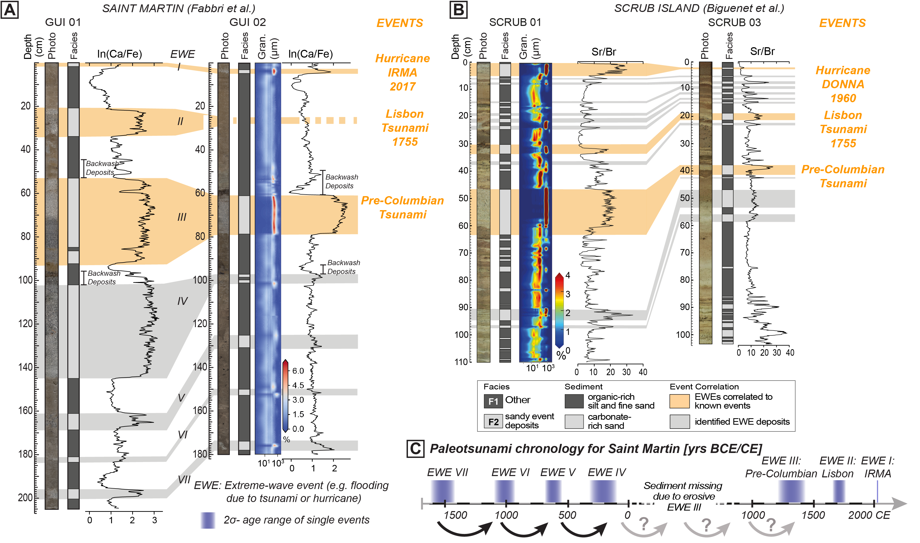
Sedimentological observations and grain-size analysis enabled the identification and distinction of two sediment facies. Facies 1 (F1) is characterized by fine-grained sediment with a silty matrix rich in organic matter (Fig. 2). It contains ~20% organic matter, one-third silicates and a carbonate content between 35% (Scrub Island) and 48% (Saint Martin), reflecting a setting with very low energy levels, and mirroring the lagoon's background sedimentation. In contrast, Facies 2 (F2) comprises significantly coarser sediments, predominantly consisting of fine to very coarse sands. F2 is dominated by carbonates, constituting ~80% at Saint Martin and 40% at Scrub Island, with minor contributions of organic matter. F2's coarse sandy composition, marked by elevated Ca/Fe and Sr/Br ratios, indicates significant marine-sediment input and suggests high-energy transport processes that can erode and resuspend background sediment. Shells and their fragments, rich in Ca or Sr, denote marine influence, while Br and Fe reflects organic matter from the lagoon or land input, respectively. Both ratios represent marine input equally well. Therefore, F2 is interpreted as the facies that likely results from EWEs. Some of the deposits right above the F2 layers (e.g. EWE III) show a geochemical signal rich in fine siliciclastic sediment with organic matter that likely corresponds to backwash deposits (Fig. 2a, b).
The EWE deposits characterized by F2 were of primary interest for cross-core correlation. The thickness of F2 layers decreases landward from GUI 01 to 02 at Saint Martin and SCRUB 01 to 03 at Scrub Island, supporting a marine origin of the deposits. Micro-CT-derived sedimentary fabric of event deposits reveals the spatial and geometrical arrangement of their sand grains, offering insights into flow direction and transport medium strength during deposition. A bimodal low-angle fabric dominated the Pre-Columbian tsunami deposit on both islands, distinguishable from the uni- and multi-modal fabric of other EWEs at these sites (Fig. 2). While there is no unique proxy to distinguish between tsunami and hurricane deposits, our recent results show that paleo-flow reconstruction based on micro-CT data may resolve this challenge in the near future.
The recurrence of extreme-wave events
We have identified a total of seven and 25 EWE layers over the last 3500 and 1600 years at Saint Martin and Scrub Island, respectively (Fig. 2). Considering the very small deposit thickness of 1–2 cm of the Category 5 Hurricane Irma at Saint Martin, and the lack of backwash material, older EWEs with thicker deposits must likely be of tsunamigenic origin in this lagoon. This is also supported by CT-derived sedimentary fabric, allowing for a tentative paleotsunami chronology for the island (Fabbri et al. 2023). Moreover, geochemical data (Biguenet et al. 2021) and sedimentary fabric (Biguenet et al. 2022) enabled the identification of two tsunamis among the 25 EWEs on Scrub Island. Scrub Island appears to respond more sensitively to EWEs (including some historic events), compared to the more sheltered Saint Martin lagoon, which is less exposed to the open ocean.
Between 1500 and 0 yr cal BCE, paleotsunamis occurred every 400 to 500 years on Saint Martin (Fig. 2c). The absence of events between 0 and 1350 yr cal CE is likely due to the extensive erosion caused by the Pre-Columbian tsunami, also identified on Scrub Island, and at the regional scale (Cordrie et al. 2022), emphasizing its destructive force. Engel et al. (2016) reported a possible minor event at ~450 yr cal CE, and a major paleotsunami at ~950 yr cal CE, the former observed on Barbados, Yucatan (Mexico), Anguilla and Scrub Island, potentially filling the chronological void. This allows for two potential hypotheses: 1) A regular seismic cycle of strong tsunamigenic earthquakes every 400 to 500 years with a hiatus due to erosion; or 2) Clusters of megathrust earthquakes, referred to as "super seismic cycles", known from many subduction zones and strike-slip faults worldwide (Philibosian and Meltzner 2020), assuming a phase of seismic quiescence instead of a hiatus.
ACKNOWLEDGEMENTS
This work was supported by the Institut France-Québec maritime, the LABEX UnivEarthS project, the Interreg Caraïbes PREST, FEDER (European Community program) and was part of the ANR CARQUAKES project.
affiliationS
1EDYTEM, Université Savoie Mont-Blanc, CNRS, Le Bourget du Lac, France
2Université de Paris, Institut de physique du globe de Paris, CNRS, France
3Institut des sciences de la mer de Rimouski (ISMER), Canada Research Chair in Marine Geology, Université du Québec à Rimouski and GEOTOP, Rimouski, Canada
4Institute of Geological Sciences & OCCR, University of Bern, Switzerland
5LMV, Université Clermont Auvergne, CNRS, IRD, OPGC, Clermont-Ferrand, France
6La Rochelle Université, CNRS, LIENSs, La Rochelle, France
contact
Stefano C. Fabbri: stefano.fabbri unibe.ch
references
Biguenet M et al. (2021) Sediment Geol 412: 105806
Biguenet M et al. (2022) Mar Geol 450: 106864
Cangialosi JP et al. (2018) Hurricane Irma, NOAA and National Hurricane Center, 111 pp
Cordrie L et al. (2022) Earth-Sci Rev 228: 104018
Costa PJM, Andrade C (2020) Sedimentology 67: 1189-1206
Engel M et al. (2016) Earth-Sci Rev 163: 260-296
Fabbri S et al. (2023) 21st Swiss Geoscience Meeting, Mendrisio, Switzerland
Feuillet N et al. (2011) J Geophys Res Solid Earth 116: B10308
MacManus K et al. (2021) Earth Syst Sci Data 13: 5747-5801
NOAA, (2020) Historical Hurricane Tracks (website), accesed 4 April 2023
Philibosian B, Meltzner AJ (2020) Quat Sci Rev 241(1): 106390
Reimann L et al. (2023) Cambridge Prisms: Coastal Futures 1 (e14): 1-12
Roger J et al. (2011) Pure Appl Geophys 168: 1015–1031
SHOM (2018) MNT bathymétrique de façade de Saint-Martin et Saint-Barthélemy (Projet Homonim)
Wallace EJ et al. (2021) J Geophys Res Letter 48(1): e2020GL091145

