- Home
- Publications
- PAGES Magazine
- Tsunami Deposits To Reconstruct Major Earthquakes Chronology In Southern Peru
Tsunami deposits to reconstruct major earthquakes chronology in southern Peru
Cuven S., Paris R., Audin L., Mitra S., Gielly L. and Aguirre E.
Past Global Changes Magazine
32(1)
38-39
2024
Cuven S.![]() 1, Paris R.
1, Paris R.![]() 2, Audin L.
2, Audin L.![]() 3, Mitra S.
3, Mitra S.![]() 2 , Gielly L.
2 , Gielly L.![]() 4 and Aguirre E.5
4 and Aguirre E.5
A study of tsunami deposits preserved in coastal sedimentary sequences of southern Peru suggests that five very large tsunamigenic earthquakes with moment magnitude (Mw) >8.5 occurred during the last 2500 years, including the 1604 and 1868 CE tsunamis.
Timescales of tsunami and earthquake record
Subduction-zone megathrust faults cause the largest earthquakes on Earth. The recent megathrust earthquakes in 2004 in Sumatra (Indonesia; Mw 9.3) and 2011 in Tōhoku-oki (Japan; Mw 9.1), and their associated tsunamis, highlighted a weakness in the integration of the time factor in hazard evaluation. Indeed, tsunami-hazard evaluation must combine both historical evidence of tsunamis (recorded or observed events) and geological evidence (tsunami deposits). This is particularly critical when the historical catalogs are limited in time, and/or when the largest events have a long period of return, thus being potentially absent from the historical record.
In Peru, the time period covered by the catalogs of earthquakes and associated tsunamis is limited to the last five centuries, with the oldest event dating back to 1582 CE (Comte and Pardo 1991; Dorbath et al. 1990). Time acts as a filter, and very few earthquakes of Mw <7.5 are mentioned in the archives before the 19th century (Kulikov et al. 2005). Paleotsunami studies have the potential to enlarge the timescale of tsunami catalogs up to the early Holocene. This represents a crucial contribution to the assessment of earthquake and tsunami hazards.
Historical tsunamis in southern Peru
In Peru, based on statistics of historical events, the return periods of Mw ~8 and Mw ≥8.7 tsunamigenic earthquakes are estimated at 10 and 100 years, respectively (Kulikov et al. 2005). A total of 10 tsunamigenic earthquakes have occurred in southern Peru (south of Nazca Ridge) since 1530 CE (Comte and Pardo 1991; Dorbath et al. 1990; Okal et al. 2002), including five major events in 1604 (Mw 8.7, with a tsunami up to 16 m high when arriving on shore), 1687 (Mw 8.4, 10 m), 1784 (Mw 8.4, 4 m), 1868 (Mw 8.8, 18 m), and 2001 CE (Mw 8.4, 8.8 m). Regional earthquakes in central Peru (1687, 1746 and 2007 CE) and northern Chile (1615, 1877 and 2014 CE) also generated tsunamis that were observed on the coasts of southern Peru. Trans-Pacific tsunamis caused by far-field sources (Japan, Tonga, etc.) typically produce wave heights lower than 3 m on the coast of Peru.
Additionally, Spiske et al. (2013a) found two tsunami deposits dated 615 BCE–119 CE, and 207 BCE–255 CE, which represent the only evidence of paleotsunamis published so far in southern Peru. Abad et al. (2020) described a coastal boulder-field dated between the 13th and 16th centuries.
Paleotsunami sites and methods
In this study we investigated two coastal sites in southern Peru: the Ite lagoon (south of Ilo) and the Quilca floodplain (south of Camana) (Fig. 1). Samples were collected along trenches, using both U-channels and push cores, as well as bulk samples of available sediments. Laboratory analyses consist of combining XRF core-scanner, SEM (Scanning Electron Microscope), X-ray computed tomography (X-CT), and DNA metabarcoding methods to characterize the structure, grain size, fabric, chemical, mineralogical, and biological compositions of the sediments. This workflow was previously applied to storm and tsunami deposits, as explained in Sabatier et al. (2010), Cuven et al. (2013), Paris et al. (2020) and Biguenet et al. (2022).
We also tested a DNA approach: samples of tsunami and terrestrial deposits were directly collected from the field with sterile devices, immediately dessicated for preservation and processed following the methodology by Bremond et al. (2017), specifically targeting 18S rDNA region V7 (a region of nuclear DNA encoding 18S nuclear ribosomal RNA, as commonly used for eukariotes in metabarcoding: Guardiola et al. 2016). Samples of wood fragments and organic sediment were 14C dated at Laboratoire de Mesure du Carbone in France using accelerator mass spectrometry (Dumoulin et al. 2017).
A 2500-year chronology of tsunami deposits
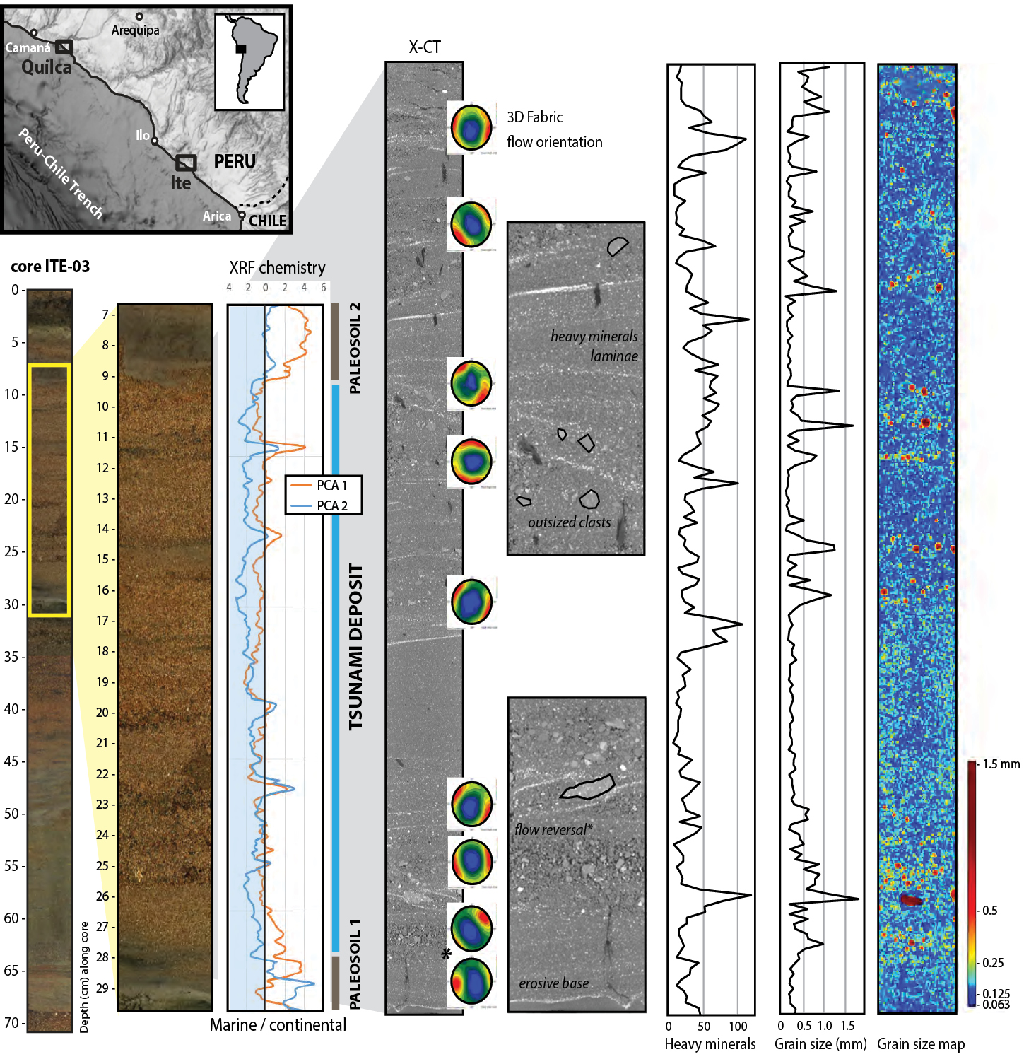
Tsunami deposits identified in the sedimentary sequences appear as fine-to-medium sand units intercalated in dark-brown lagoonal mud at Ite, or brownish overflow silt at Quilca. These sand units are characterized by an increased marine signature compared to background sediments, as evidenced by vertical variations of the chemical composition (Fig. 1). Grain-size distribution shows that the sand units have a variable proportion of silt and clay, which reflects the mixing of different sediment sources. The sand is made of silicate minerals (quartz being dominant), with some oxides, as well as wood, plants, and sparse marine bioclasts (foraminifera, small fragments of shells). DNA analyses record a mixed marine-continental composition, especially in Quilca where DNA show marine algae, ciliates and worms, Pacific coral reef fish, along with brakish diatom species, Andean plants, and terrestrial ciliates and worms.
The base of the sand units is often erosive, thus forming rip-up clasts of mud or soil inside the sand. Their internal structure is emphasized by horizontal to low-angle bedding, heavy-minerals laminae, erosive discontinuities between subunits, and vertical variations of the grain size (including clast-supported lenses of coarse sand, and matrix-supported silt-rich subunits). Different types of sedimentary fabric were inferred from X-CT: flow-parallel fabric oriented landward (wave uprush) or seaward (flow-reversal or backwash), and flow-transverse fabric (Fig. 1).
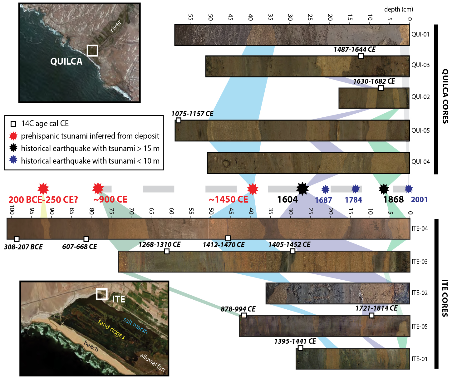
The sedimentary sequences (and thus the tsunami chronology) are time-constrained by 14C ages that range between 308–207 BCE (100 cm depth) to 1721–1814 CE (10 cm depth) at Ite, and 1075–1157 CE (60 cm depth) to 1630–1682 CE (7 cm depth) at Quilca (Fig. 2). The 1604 and 1868 CE tsunamis are well recorded at both sites. The 1604 CE tsunami deposit is particularly thick (up to 20 cm) at Ite. We also found three prehispanic tsunamis. A major tsunami at ~1450 CE is preserved at both sites. Two older tsunamis are found at Ite: one at ~900 CE, and the oldest one between 200 BCE and 250 CE (which could correspond to the 207 BCE–255 CE event of Spiske et al. 2013a).
 |
|
Figure 2: Location of the core samples in Quilca and Ite, and synthetic extended chronology of tsunami events in Southern Peru. |
Earthquake magnitude versus tsunami-deposit preservation
In southern Peru, the last five major earthquakes (Mw ≥8.4) occurred at quite regular intervals (every 83–133 years), but there is a variability in the rupture extent (Dorbath et al. 1990; Philibosian and Meltzner 2020). The more extensive ruptures occurred in 1604 and 1868 CE, which is concordant with the tsunami-deposit records. Indeed, historical tsunamis with wave heights >15 m, such as the 1604 and 1868 CE ones, are well recorded in the coastal stratigraphy (tsunami deposits being typically 5–20 cm thick), whereas tsunamis with wave heights <10 m in the study area (e.g. 1687, 1784 and 1877 CE) are apparently not preserved in lagoons that are protected by coastal sand ridges.
As an example, the 2001 CE tsunami had wave heights up to 2.3 m in Quilca (Okal et al. 2002). During our field survey in 2017, traces of the 2001 CE tsunami were still visible in the form of irregular and sparse sand layers (up to 1.5 cm thick at 100 m from the shoreline, but 420 m away from the riverbed), abundant drift wood, and anthropic debris. Spiske et al. (2013b) reported a decrease of the average thickness of the 2001 CE tsunami deposits from 0.5–28 cm to 0.1–6 cm in only six years, and concluded that even in such an arid environment, the sedimentary record of tsunamis may not fully represent a comprehensive tsunami hazard.
Thus, there seems to be a threshold of earthquake magnitude (Mw >8.5 in southern Peru) to generate a tsunami large enough to be preserved in the sedimentary record. Our study reveals that only five very large earthquakes left tsunami deposits in coastal lagoons of southern Peru during the last 2500 years, while 10 tsunamis occurred during the last 500 years.
ACKNOWLEDGEMENTS
Grant IRD and Labex OSUG@2020 (ANR10 LABX56). CNRS-INSU ARTEMIS Radiocarbon AMS at LMC14. A.L. Develle and P. Sabatier (EDYTEM Chambéry ), E. Ando and P. Charrier (3SR Grenoble). ClerVolc contribution n° 636.
affiliationS
1Mercator Ocean International, Toulouse, France
2Université Clermont Auvergne, CNRS, IRD, OPGC, Laboratoire Magmas et Volcans, Clermont-Ferrand, France
3IRD, Université Grenoble Alpes, CNRS, ISTerre, Grenoble, France
4Laboratoire d’ÉCologie Alpine, Université Grenoble Alpes, CNRS, LECA, Grenoble, France
5INGEMMET, Lima, Peru
contact
Raphaël Paris: raphael.paris uca.fr
references
Abad M et al. (2020) Sediment 67: 1505-1528
Biguenet M et al. (2022) Mar Geol 450: 106864
Bremond L et al. (2017) Quat Sci Rev 170: 203-211
Comte D, Pardo M (1991) Nat Haz 4: 23-44
Cuven S et al. (2013) Mar Geol 337: 98-111
Dorbath L et al. (1990) Bull Seism Soc Am 80: 551-576
Dumoulin J-P et al. (2017) Radiocarbon 59: 713-726
Guardiola M et al. (2016) Plos One 11(4): e0153836
Kulikov EA et al. (2005) Nat Haz 35: 185-209
Okal EA et al. (2002) Seismol Res Lett 73: 904-917
Paris R et al. (2020) Sediment 67: 1207-1229
Philibosian B, Meltzner AJ (2020) Quat Sci Rev 241: 1066390
Sabatier P et al. (2010) Sed Geol 228: 205-217
