Water resources - How severe will freshwater resource shortages be on a regional scale? [Present]
Richard Harding
Centre for Ecology & Hydrology, Wallingford, UK; rjh ceh.ac.uk
The terrestrial water budget is at the heart of many environmental issues. Water is crucial to agricultural production, the healthy functioning of biogeochemical cycles, biodiversity, industrial production and human health. Extremes play an important role: floods and droughts provide pressure points on water scarcity and environmental damage. Increasing population and wealth in many regions of the world are increasing the pressure on available water, a situation likely to be exacerbated by human activities including climate change.
As yet it is difficult to discern an increase in rainfall globally despite its likelihood in a warmer world, partly because changes in precipitation in different regions tend to cancel out. With increasing precipitation at high latitudes, decreasing precipitation in the subtropical regions and possibly changing distribution of precipitation in the tropics by the shifting position of the Intertropical Convergence Zone (see e.g. Zhang et al. 2007).
Extremes of rainfall have increased in Europe and worldwide (e.g. Zolina et al. 2010) and these are likely to be linked with increased greenhouse gases (Pall et al. 2011). Overall droughts have also increased through the 20th century and are predicted to increase further in the 21st century. However, the projected changes in rainfall patterns depend on atmospheric circulation patterns, which are not always represented well in the climate models. And the basin-scale response of river flows also depends on the regional-scale basin characteristics and human interventions, besides the warming induced by greenhouse gases.
In fact many of the observed trends in the hydrological cycle can be attributable to human activities beyond increasing CO2. A decrease in groundwater, particularly noticeable in mid-western USA and northern India can be inferred from GRACE satellite data (e.g. Rodell et al. 2009), almost certainly due to over extraction for irrigation. Terrestrial evaporation has increased through the 1980s and 90s, most probably due to decreasing aerosols (Jung et al. 2011). Increasing runoff and increasing high flows linked to the melting of glaciers have been observed in the Alpine region. Flows in the northern rivers have increased, but it is unclear whether this is due to land-cover change, increasing precipitation or increasing CO2 levels (see Gerten et al. 2008).
It is very likely that global warming has influenced river flows, but often either the long-term river-flow data are not available or the changes are masked by changes in land cover or extraction. Collaboration between climate, hydrological and water resource scientists working across a wide variety of scales is thus essential. In recent years this has been achieved with the bringing together of a wide variety of data sets and models (see e.g. Weedon et al. 2011; Haddeland et al. 2011).
 |
|
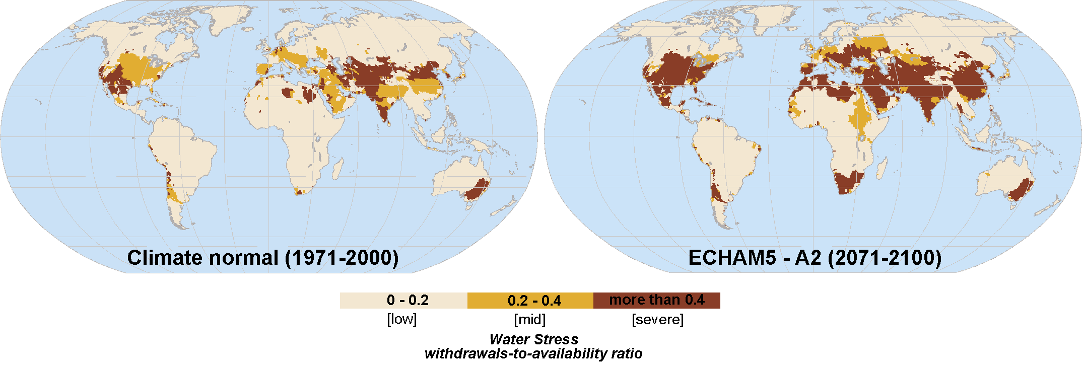
Figure 1: Water stress, calculated as the ratio between water withdrawals and availability, for the late 20th and 21st centuries (see Flörke and Eisner 2011). |
Climate models continue to suggest decreases of rainfall in the semi-arid regions of the world, such as the Mediterranean region, southern USA and Central America, southern Australia and southern Africa. When translated into river flows and available water we predict increasing water scarcity in these regions but also in China, India and the Middle East, where populations and water consumption are rising fast (Fig. 1).
There is considerable variation in the both the global hydrology and climate models (Haddeland et al. 2011). Also regional analyses require the incorporation of many additional processes, such as irrigation and groundwater (and the interactions between them). At present the best approach seems to be to use an ensemble of available hydrological models in tandem with the ensemble of climate models used by the Intergovernmental Panel on Climate Change.
There has been considerable progress on quantifying the global and regional terrestrial water balance in recent years. Considerable uncertainties, however, remain particularly at the regional scale where in situ data on rainfall and runoff are limited. Satellite products and modeling can to an extent fill these gaps, but there remains a need to maintain surface based networks and the free flow of data.
selected references
Full reference list online under: http://pastglobalchanges.org/products/newsletters/ref2012_1.pdf
Flörke M and Eisner S (2011) The development of global spatially detailed estimates of sectorial water requirements, past, present and future. WATCH Technical report number 46
Haddeland I et al. (2011) Journal of Hydrometeorology 12(5) 869-884