New paper by Rovere A, Ryan DD, Vacchi M, Dutton A, Simms AR and Murray-Wallace CV.
Rovere A, et al. have published a new paper in Earth System Science Data on "The World Atlas of Last Interglacial Shorelines (version 1.0)".
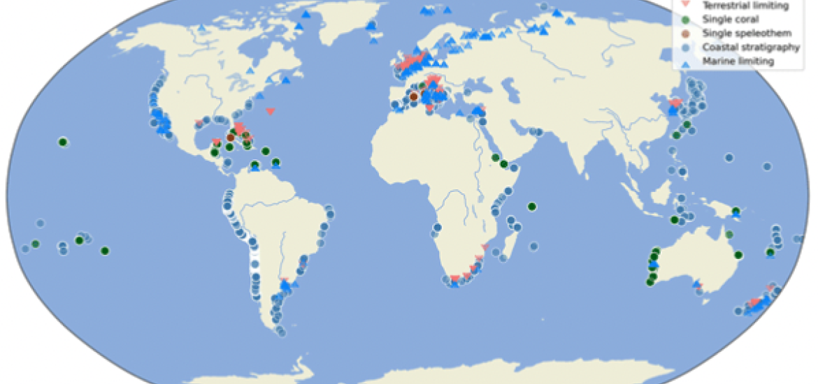
The authors present version 1.0 of the World Atlas of Last Interglacial Shorelines (WALIS). WALIS is "a database collecting data on Last Interglacial (70-125 ka) sea-level proxies. Each data point in WALIS follows a standard template that can be filled from an online interface".
The paper summarizes more than 100 years of publications reporting sea-level indicators dated to the last Last Interglacial (125 ka) with over 3000 data points. The authors maintain that "by creating a centralized database of sea-level proxy data for the Last Interglacial, the WALIS database will be a valuable resource to the broader paleoclimate community to facilitate data–model integration and intercomparisons, assessments of sea-level reconstructions between different studies and different regions, as well as comparisons between past sea-level history and other paleoclimate proxy data."
The data used in this study were extracted from WALIS, a sea-level database interface developed by the ERC Starting Grant WARMCOASTS (ERC-StG-802414) in collaboration with PALSEA (PAGES/INQUA) working group.
The development of the WALIS visualization interface was sponsored by the PAGES “Data Stewardship Scholarship” given to Sebastian Garzòn.
The data were compiled within a Special Issue in the journal Earth System Science Data, all available here:
https://essd.copernicus.org/articles/special_issue1055.html with data for each single paper archived here
https://zenodo.org/communities/walis_database/?page=1&size=20
The data (including a collated version in CSV, XLS and mySQL) is available in this Zenodo repository:
https://zenodo.org/record/7348242#.Y7XRTi1Q1-U
If you are unsure where to start reading about WALIS, try either the ESSD Editorial
https://essd.copernicus.org/articles/15/1/2023/ or the technical manual https://walis-help.readthedocs.io/
If you just want to explore the database, here is a handy tool:
https://warmcoasts.shinyapps.io/WALIS_Visualization/
And here is the GitHub page with all tools and scripts written to analyse the database. Feel free to edit and send the group bug reports!
https://alerovere.github.io/WALIS/
PAGES Data Stewardship Scholarships are available to PAGES working groups only, to help collate and safely store valuable research data. Data stewardship is a central objective of PAGES. These activities are part of the entire lifecycle of research, from the conception to the archiving of data, with the goal of providing future data users with high quality and easily accessible data. The stipend is for a data steward to work on data compilation and curation, with the goal of generating a data product for publication in a data-oriented journal or similar. Updating existing databases and database maintenance are also eligible for support.
> Find out more about PAGES Data Stewardship Scholarships
PALSEA was awarded a Data Stewardship Scholarship in May 2021.
Data steward
Sebastian Garzon, University of Münster
John M. Doherty, The Chinese University of Hong Kong
Goal
We had two main goals for this Data Stewardship Scholarship, shared between two ECRs:
1) Filling the Holocene data into the MySQL WALIS template
2) Expanding/improving upon the existing visualization interfaces
The work is based on the WALIS (World Atlas of Last Interglacial Shorelines) interface built in the framework of the European Research Council Starting Grant “WARMCOASTS” (PI A. Rovere). The interface was initially dedicated to Last Interglacial (and more in general, Pleistocene) sea-level proxies. Thanks to the DSS scholarship, we had the impulse to modify it to allow inserting Holocene sea-level data. As of December 2021, the web interface includes such function, built upon the template of Khan et al., 2020. We have already implemented an interface to visualize Last Interglacial sea-level data, and we are working towards including also Holocene data in the visualization.
John M. Doherty has been working towards integrating previously organized Holocene sea-level reconstructions (via HOLSEA) into the World Atlas of Last Interglacial Shorelines (WALIS) database framework. The first component of this work is to recalibrate thousands of radiocarbon-dated data points to the most recent calibration curves (IntCal20 and Marine20). We have modified an existing calibration algorithm, IOSACal, in Python. The second part of this project is to organize Holocene data into an appropriate spreadsheet format for mass recalibration. Most, if not all, of the publically accessible Holocene data, have been downloaded and organised in this way as of March 2022.
Sebastian Garzon is working on the visualization interface to the database. This part of the project consists in developing a reproducible Shiny app platform that facilitates the exploration of WALIS. During this project, the DSS has focused on two main areas: developing tools to summarize the content of WALIS and improving the reproducibility and interaction of the platform. On the first component, a methodology was developed to merge sea-level index points with multiple temporal and relative sea-level constraints in a single constraint (Cloudpoint). This aims to facilitate the integration and comparison of sea-level indicators with other types of sea-level information (e.g., models). On the second component, the DSS has improved the backend and frontend of the initial Shiny application by including additional documentation and reducing the code complexity. This aims to facilitate code readability and guarantee the Shiny application's reproducibility.
Repository
The WALIS database the code for the visualization interface are stored in Zenodo. A page summarizing the data and code available so far for WALIS is available here: https://alerovere.github.io/WALIS/.
Note that the data and visualization interface have their own DOI, as the stable versions are archived in Zenodo.
Final product
A visualization interface available through a website to query sea-level data and download the results.
> Visit the PALSEA webpage
> Visit the PALSEA external website