By: Gouramanis C., Yap W., Srinivasalu S., Anandasabari K., Pham D.T. and Switzer A.D.
Available in: Past Global Changes Magazine 32 (1)
> Access the contents of this issue
> Download this article as pdf
Comparing recent cyclone and tsunami deposits from southeast India
We examined multi-proxy evidence preserved within the 2004 Indian Ocean tsunami and overlying 2011 Cyclone Thane deposits on the southeast coast of India. We found no distinguishing features between the deposits.
Over 35% of the Earth’s population lives in coastal zones and is vulnerable to a suite of acute (e.g. storms, cyclones and tsunamis) and chronic (e.g. sea-level rise) coastal hazards (UNEP). Many coastlines and communities are at risk of one or more of these coastal hazards. To properly prepare coastlines that are at risk of these acute coastal hazards, coastal communities and decision makers require detailed knowledge of the occurrence, frequency and magnitude of these events on their coastlines. Fortunately, large storms infrequently impact coastlines, and tsunamis are rare events, but when either event strikes, the outcome can be devastating. Unfortunately, the infrequency of large events makes it challenging for decision makers and communities to prepare.
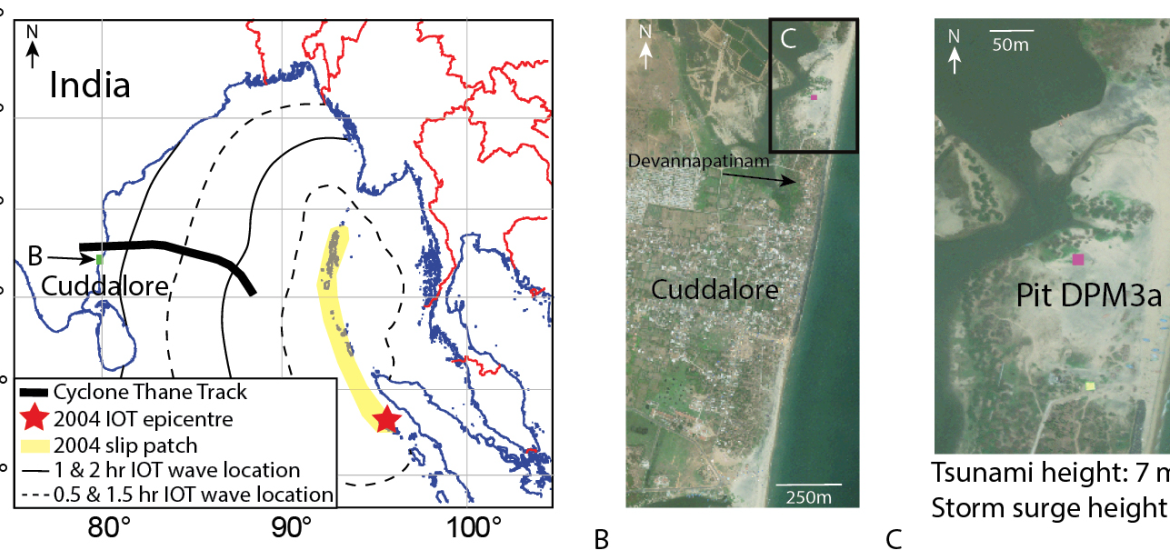
To overcome this challenge, coastal geological records of both depositional and erosional characteristics have been examined to identify signatures of past coastal hazards (e.g. Switzer et al. 2014). These studies typically focus on areas where a coastal hazard has been encountered (e.g. Jankaew et al. 2008). However, to appropriately identify which coastal hazard has affected a region, modern analogues must be examined to identify characteristics that are unique to each hazard (e.g. Morton et al. 2007). Although much effort has focused on distinguishing between storm and tsunami characteristics in the geological record, these studies have examined deposits of tsunami and storms from different coastlines (e.g. Kortekaas and Dawson 2007; Morton et al. 2007), or have examined deposits that have occurred decades apart and may have undergone alteration (e.g. Nanayama et al. 2000). To date, very few studies have examined the geological signatures of a known tsunami and known storm deposit from the same location (e.g. Pham et al. 2017; Yap et al. 2021). We contribute to this growing body of knowledge by examining the beautifully preserved sedimentary deposits formed by the 26 December 2004 Indian Ocean tsunami (IOT), and the 2011 Cyclone Thane from Devanampattinam on the northern outskirts of Cuddalore, southeast India (Fig. 1a).
The 2004 tsunami and the 2011 cyclone
The 2004 IOT was triggered by a magnitude moment 9.2 earthquake centered off northeastern Sumatra and propagated northwards along 1500 km of the Sumatran–Andaman subduction zone, killing 230,000 people (Fig. 1). The IOT propagated across the Bay of Bengal and struck southeast India at 8:30 a.m. local time, causing approximately 16,000 deaths and US$2 billion (International Recovery Platform 2004). At Devannampatinam, the tsunami had a maximum run-up height of 7 m and 700 m of inundation; and deposited a 38 cm thick sediment deposit.
Cyclone Thane made landfall near Cuddalore between 6:30 and 7:30 a.m. on 30 December 2011, causing over US$1 billion in damage and killing 48 people (Fig. 1; IMD 2012). At Devannampatinam, the storm surge run up was approximately 2 m, inundated approximately 300 m and deposited 27 cm of sediment.
Comparison of Cyclone Thane and 2004 IOT sedimentary deposits
Using satellite imagery of the region and discussions with local survivors, we identified a site approximately 300 m north of the village of Devannampatinam that preserves the 2004 IOT and 2011 Cyclone Thane deposits (Fig. 1a). The site was a partially vegetated; sandy beach dunes and backshore lagoonal environments formed from the closure of the Pennai River. At this site we excavated the 95 cm deep pit DPM3a and conducted multi-proxy analysis at centimetre-scale resolution that included stratigraphy, sediment grainsize, grain shape, and heavy mineral counts (Fig. 2a). Multivariate statistical analysis of the sedimentary variables demonstrates distinct differences between storm and tsunami deposits (Fig. 2b). We analyzed the microbial communities of 26 samples from the pit (Yap et al. 2021), but present the results of 13 representative samples here (Fig. 2c).
From deepest to shallowest, the sedimentary units observed in Pit DPM3a are an intertidal sand, 38 cm thick 2004 IOT deposit, a 12 cm thick layer of eolian (wind blown) sand, and the 27 cm thick Cyclone Thane deposit (Fig. 2a). All of the units consist of medium sands (average size from 0.25–0.5 mm). The intertidal unit consists of northward dipping beds and thin horizontal beds, both with distinct heavy mineral layers (10–30%; Fig. 2a). The tsunami deposit consists of two beds separated by thin heavy-mineral laminations. From the bottom to the middle of the beds, the grain size becomes larger, and from the middle of the beds the grain size becomes smaller (Fig. 2a). These two beds represent deposition from two sequential waves, and much of the sediment came from the pre-existing nearshore or onshore environments. The eolian deposit consists of sands that have been partially reworked upper-2004-IOT sediments, some leaves and plastic waste (Fig. 2a). The storm deposit is composed of horizontal layers that consist of different proportions of heavy minerals (15–60%). The layers are thicker at the bottom of the deposit and become thinner towards the top. It is likely that the sediments came from the shoreface or onshore environments (Fig. 2a).
Discriminant function analysis (DFA) of all four deposits indicates that sedimentologically, only the heavy mineral distribution in the storm deposit can distinguish the four units (Fig. 2b). However, at Silver Beach, less than 2 km south of Devanampattinam, Srinivasalu et al. (2007) and Switzer et al. (2012) described 2004 IOT deposits with abundant heavy minerals and dense laminations, in contrast with Pit DPM3a.
___
Figure 1: (A) Map of the Bay of Bengal showing the location and travel times of the 2004 IOT and Cyclone Thane storm track. (B) Satellite image of the Cuddalore coast showing the location of Devannampatinam and the pit site. (C) Satellite image of the beach near Devanampattinam where pit DPM3a was excavated.