PAGES Magazine articles
Michela Mariani1,2,3, S. Connor2,3, M.-S. Fletcher3,4, A. Romano4 and S.Y. Maezumi5
The current wildfire crisis in southeast Australia is unprecedented. The transition from Indigenous to colonial land management since 1788 has resulted in a build-up of woody fuels, which, in combination with climate change, has resulted in more extreme bushfires.
The present: unprecedented wildfires
The Australian "Black Summer" bushfires in 2019/2020 have been part of a series of recent wildfires that have attracted global media coverage and scientific interest. This event had significant immediate and ongoing financial costs, and a series of disastrous environmental consequences. With ca. 18 million hectares burned, the 2019/2020 event represents the worst fire season in the recorded history of southeast Australia thus far. Nine times more forest and woodlands burned in this single fire season than in the previous 17 years combined (Bowman et al. 2020). This event is an example of how the compounded effects of climate change and urban expansion are increasing fire impacts to levels unmatched in recorded history (Bowman et al. 2017).
The catastrophic bushfires in Australia exhibit a similar pattern of increasingly severe wildfires recorded in British Columbia (2017), California (2018, 2020), and the Amazon (2019). These regions were long managed by Indigenous peoples through cultural burning and were then subsequently invaded and colonized by Europeans who implemented different land management practices, including fire suppression. Following this transition, cultural burning was often banned or suppressed in the subsequent centuries, which has had important consequences for fire regimes and the ecosystems in which they operated.
In the wake of these events, researchers and policymakers have been urged to address questions about future land and fire management by including the legacy of historical burning on present landscapes. For example, much attention has been directed towards traditional landscape management's implications for bushfire mitigation, and how past landscapes were managed throughout the millennia before British invasion and colonization of Australia (Steffensen 2020). It is imperative that we understand how landscapes have changed under different management techniques (Indigenous vs. post-colonial). Such knowledge can be provided by paleoecological studies, which can offer a unique and unbiased view of this critical issue.
 |
|
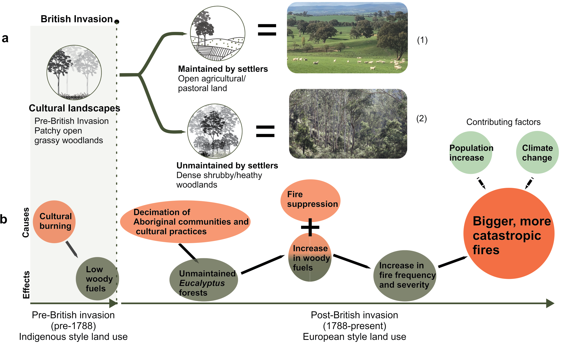
Figure 1: Map of Southeast Australia showing sites with a positive percent increase in (A) shrub cover and (B) charcoal influx following British colonial settlement post-1788 CE (modified from Mariani et al. 2022). Shrub cover and charcoal increases are evident in forest/woodland areas along the coast of SE Australia, where the 2019/2020 fires had the most extreme impacts (pink outline). Sites showing no increase in (A) shrubs or (B) charcoal are shown as black triangles. |
The past: changes in land cover and fire since colonization in southeast Australia
Indigenous people have inhabited the Australian continent for at least 65,000 years (Clarkson et al. 2017). Before British colonization in 1788 CE, Indigenous people managed Australia's flammable vegetation using long-standing firing practices called "cultural burning" (Gott 2005). This management shaped the balance between herbaceous and woody biomass, limited shrub density in understorey vegetation, and maintained patchy, open woodlands and savanna-like vegetation (Gott 2005; Gammage 2011). This management occurred across a broad altitudinal gradient. Due to limited ground-to-crown connectivity and fuel abundance, this managed landscape was less prone to destructive fires than current forests (Gott 2005). In contrast, British colonists managed land through deforestation and intense firing to clear areas deemed suitable for farming (e.g. low-elevation plains). However, forests in unsuitable areas (high-elevation or rugged terrain) were left unmanaged or exploited through selective logging for firewood or timber (Griffiths 2001).
Currently, there is a vast array of evidence for sophisticated, Indigenous cultural burning practices, as provided by oral tradition, historical, and ethnographic sources (Gott 2005; Gammage 2011; Pascoe 2014). The latter depict much of the southeast Australian pre-colonial landscape as open and grassy, with scattered trees and shrubs (Gammage 2011 and references therein). However, empirical evidence is scant, and a consensus in the scientific community is lacking. We carried out the first regional-scale scientific assessment of the land-cover and fire activity change before and after British colonial settlement of SE Australia (Mariani et al. 2022). This new work presents an integration of novel pollen-based land-cover reconstructions (REVEALS modeling; Sugita 2007) and fire histories.
Our land-cover reconstruction of SE Australian vegetation shows that pre-colonial landscapes were predominantly grassy, with low tree cover (14% on average), consistent with a savanna-like environment at the regional scale. Our findings agree with the long-neglected, cultural knowledge of Indigenous people and corroborate historical records, including early settlers' diaries and artworks. These findings contrast with previous interpretations based on unmodeled pollen results, which grossly overestimated past tree cover across the region (Mariani et al. 2022). Since colonization, shrub cover increased across much of the SE Australian region, thickening the understorey of forests and woodlands (Fig. 1a; Mariani et al. 2022).
Long-term fire history reconstructions demonstrate that fire has long been present in the Australian landscape, deeply intertwined with climatic change and Indigenous cultural practices (Kershaw et al. 2002; Mooney et al. 2011). The consistent occurrence of charcoal in sediments prior to 1788 (Mooney et al. 2011) indicates that fire was an almost universal feature of the southeast Australian landscape. After British colonization, we detected a substantial increase in biomass burned across most areas, especially within woodland/forest (Fig. 1b). This recent increase led to biomass burning levels exceeding levels in the Holocene record (Mariani et al. 2022; Mooney et al. 2011).
Fire's increase after colonial settlement has multiple non-exclusive causes: (1) disruption of Indigenous burning, which would have promoted the accumulation of woody biomass conducive to more intense bushfires; (2) post-colonial firing practices targeted at the removal of woody biomass for land clearance in areas deemed suitable for agriculture according to European standards; and/or (3) recent climate change favoring dryness of fuels and biomass accumulation through CO2 fertilization.
Paleodata help refine this list of possible causes. Our land-cover and fire activity reconstructions indicate divergent trends in different land-use areas (open vegetation areas vs. forests/woodlands), with open vegetation areas displaying a decrease in woody cover following colonial settlement, while an increase in woody fuels occurred in forests/woodlands. This suggests that management practices, rather than the spatially consistent influences of regional climate, are likely to blame for the increase in fire. Indeed, the greatest post-colonial shrub increase occurred in the forest/woodland zones most affected by the 2019/2020 wildfires (Fig. 1a). While extreme fire-weather driven by climate change was responsible for fuel dryness during this event (Nolan et al. 2020), we suggest that the increased volume and connectivity of woody fuels, due to shrub encroachment following the cessation of cultural burning, has raised wildfire risks to unprecedented levels (Fig. 2).
 |
|
Figure 2: Summary diagram showing (A) the diverging trajectories of Southeast Australian landscapes following colonial settlement; (1) areas maintained by settlers for farming purposes; (2) areas not maintained by settlers undergoing an increase in shrub cover (Mariani et al. 2022); (B) trajectory of change in forests/woodlands since British invasion (reproduced from Fletcher et al. 2021a). |
The future: restoring Indigenous fire management
Following the unprecedented 2019/2020 wildfire event, some researchers and policymakers have advocated for the return and expansion of Indigenous cultural burning practices to mitigate climate-driven catastrophic wildfires. However, there are various barriers to the effective reinstatement of Indigenous fire management in SE Australian forests. For example, there is some uncertainty about the degree to which Indigenous people managed high biomass and extremely flammable Eucalyptus forests (77% of Australian total forest area) prior to 1788. Researchers at the University of Melbourne and the Australian National University, under the guidance and inspiration of local Indigenous communities, are currently collecting high-resolution data from targeted forest areas within SE Australia through the Discovery Indigenous Australian Research Council (ARC)-funded project, PF-FIRE (Past Fire Frequency and Intensity Reconstructions; pf-fire.science.unimelb.edu.au).
A related issue is the myth of "wilderness" areas, which are depicted as uninhabited, free from past human agency, that attract visitors globally. This affects public perceptions, and influences land-management decisions in colonized lands, neglecting Indigenous people's agency on the landscape (Fletcher et al. 2021b). SE Australian forests and woodlands cannot be defined as ''wilderness'', as they have been the homelands of Indigenous Australians and, as such, cannot be conceptualized in dualistic "nature vs. culture" terms. This dualistic thinking has underpinned land management and created legal barriers that prevent Indigenous people from efficiently and effectively managing their lands. For more effective land and fire management, Indigenous people must be engaged in all stages of scientific research and the development of policies and practices aimed at mitigating extreme bushfires in southeast Australia.
affiliations
1School of Geography, University of Nottingham, Nottingham, UK
2School of Culture, History and Language, Australian National University, Canberra, Australia
3Centre of Excellence for Australian Biodiversity and Heritage, ANU node, Canberra, Australia
4School of Geography, Earth and Atmospheric Science, University of Melbourne, Melbourne, Australia
5Institute for Biodiversity & Ecosystem Dynamics, University of Amsterdam, The Netherlands
contact
Michela Mariani: Michela.Mariani nottingham.ac.uk
references
Bowman DMJS et al. (2017) Nat Ecol Evol 1: 0058
Bowman D et al. (2020) Nature 584: 188-191
Clarkson C et al. (2017) Nature 547: 306-310
Fletcher MS et al. (2021a) Fire 4: 61
Fletcher MS et al. (2021b) Proc Natl Acad Sci USA 118: e2022218118
Gammage B (2011) The biggest estate on Earth: How Aborigines made Australia. Allen and Unwin, 384 pp
Gott B (2005) J Biogeogr 32: 1203-1208
Griffiths T (2001) Forests of ash: An environmental history. Cambridge University Press, 248 pp
Kershaw P et al. (2002) In: Bradstock RA et al. (Eds) Flammable Australia: The fire regimes and biodiversity of a continent. Cambridge University Press, 488 pp
Mariani M et al. (2022) Front Ecol Environ, doi:10.1002/fee.2395
Mooney S et al. (2011) Quat Sci Rev 30: 28-46
Nolan RH et al. (2020) Glob Chang Biol 26: 1039-1041
Daniele Colombaroli![]() 1 and Evan Larson2
1 and Evan Larson2
The recent UN Climate Change Conference in Glasgow (COP26) highlighted key priorities for supporting climate mitigation goals and strengthening policies on adaptation to future climate changes (UNFCCC 2021). In particular, the Glasgow Leaders' Declaration on Forests and Land Use pledged the conservation and sustainable management of forests, with the primary goal to end deforestation by 2030 (Glasgow Leaders' Declaration 2021).
Such ambitious initiatives highlight the urgent need for more sustainable land-use practices to avoid disastrous ecological losses. Challenges emerge, however, from conflicts between conservation targets and socio-ecological and environmental needs (Colombaroli et al. 2019). For example, traditional land stewardship among many Indigenous cultures includes the intentional use of fire to enhance biodiversity and reduce fire risk (Lake and Christianson 2019). Yet, these practices have been curtailed over decades by fire exclusion, monoculture afforestation and other practices, often justified by a pervasive "myth" of wilderness held in many western societies (Mariani et al. p. 34). Conservation plans shaped by this myth often lack the knowledge base to reconcile set restoration targets and traditional use by local communities (Berkes 2004). Through ongoing processes of colonization, this often results in the exclusion or eradication of Indigenous cultures locally, with traditional practices rarely considered for landscape conservation (Johnson et al. p. 36).
 |
|
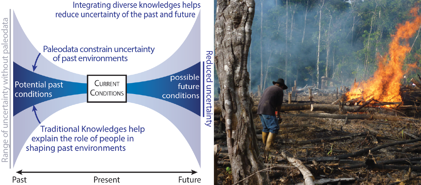
Figure 1: Left: Integrating diverse knowledge systems reduces uncertainty about past environmental conditions and how they were shaped through traditional land-use practices and relationships with the land, thereby enabling improved understanding of the range of future potential conditions and how we might engage in environmental stewardship to guide future change. Right: An example of traditional use of fire in Venezuela for shifting cultivation (photo credit: Bibiana Bilbao). |
Addressing future conservation challenges will require more holistic approaches that weave together the best scientific understanding and the wisdom of Indigenous knowledges (Mistry and Berardi 2016). In this issue, we present regional case studies showing how complex conservation challenges can be addressed through the integration of western scientific methods that inform on landscape transformations over time (paleoecology, dendroecology, and archeology), and diverse knowledge systems (Indigenous and Traditional Knowledges; Fig. 1). Merging such diverse approaches may help western thinking to better recognize the role of humans as vital parts of ecological systems, and move toward approaches to management based on reciprocal understanding, rather than the false divide between humans and nature (Caillon et al. 2017).
For example, sediment proxy records in the Mediterranean show how pastoral fires maintained a cultural landscape mosaic of high biodiversity values and lower fire risk over centuries (Coughlan et al. p. 38). In North America, fire-scarred trees serve as biocultural artefacts that provide evidence of the long-lived legacy of human connections to place, and the associated influence of fire that lingers on present landscapes (Johnson et al. p. 36). In South Africa, sediment records illustrate how local communities were highly dynamic and responsive to environmental variability, and how their responses reflected local conditions and resources (Razanatsoa and Gillson p. 40). Archeological and paleorecords in Ireland highlight the long-term spans of people-landscape interactions that shaped ecosystems in a national park (Hawthorne et al. p. 42). Such integrated knowledge reinforces the notion that people have been an integral component of landscapes for millennia, stewarding landscapes over generations, and shaping (and being shaped by) environmental variability. These cultural practices and local adaptations offer models for the maintenance and restoration of resilient landscapes (Kulkarni and Bhaskar p. 44), a crucial step in light of future climate change impacts on ecosystems (Lestienne et al. p. 46).
A recognized challenge exists for identifying best practices for researchers to engage with Indigenous communities and Traditional Knowledges, without furthering the extractive and exploitative relationships perpetrated by western societies for centuries (Copes-Gerbitz et al. p. 48). Conservation priorities set by agencies often fail to acknowledge the significance of local traditions, which often reside outside of conventional Western academic disciplines (le Grange 2004). Efforts to reshape these relationships are growing, such as the GBP 1.7 billion pledge at COP26 to support Indigenous peoples and local communities for more sustainable and effective management. A framework for these efforts is presently lacking (de Freitas et al. p. 50), but clearly this is an area of need.
New integrative, cross-disciplinary evidence is urgently needed to support a more holistic understanding of such complex issues built through dialog between ecological and socio-cultural disciplines, traditionally separated in academia. The science highlights included in this PAGES Magazine issue provide examples of how integrative socio-ecological approaches can help close the gap between disparate disciplines, while helping to bridge understanding between western scientists and Indigenous peoples. This is a primary goal of the PAGES DiverseK working group (pastglobalchanges.org/diversek), which aims to better address conservation challenges that are continuously "moving targets" in the context of ongoing rapid climate and ecosystem changes.
affiliationS
1Department of Geography, Royal Holloway University of London, UK
2Environmental Sciences and Society, University of Wisconsin Platteville, USA
contact
Daniele Colombaroli: Daniele.Colombarolirhul.ac.uk
references
Berkes F (2004) Conserv Biol 18: 621-630
Caillon S et al. (2017) Ecol Soc 22: 27
Colombaroli D et al. (2019) Policy Brief. Royal Holloway University of London, 8 pp
le Grange L (2004) S Afr J High Educ 18: 82-91
Chloé Dhaille1,2, L. Ogorzelec1 and B. Vannière![]() 1
1
In 2021, PAGES celebrated 30 years of intense activity building and managing a global scientific network to study past environmental and climate change. For this, PAGES partnered with the Maison des Sciences de l'Homme et de l'Environnement Claude Nicolas Ledoux (CNRS, Université de Franche-Comté, Besançon, France) to host a masters student in sociology, who analyzed many aspects of the PAGES program since its creation in 1991, in terms of its organization, its scientific objectives, and the epistemological strategies used.
The material collected and studied during the internship includes a selected excerpt from PAGES publications and archives, and five interviews with PAGES officials. The documentary corpus was selected to cover the longest possible period of time to obtain a total volume of text to be studied that was manageable within the three-months internship. This corpus consisted of: (1) all the editorials of Past Global Changes Magazine since the publication of the first issue in 1993, and (2) all the "science plans" defining and redefining the scientific directions of the program. Interviews were conducted with three former executive directors (Frank Oldfield, Keith Alverson, and Thorsten Kiefer), the current executive director (Marie-France Loutre), and a member of the scientific steering committee (Emilie Capron). These interviews allowed us to better understand how the scientific policy of PAGES was implemented.
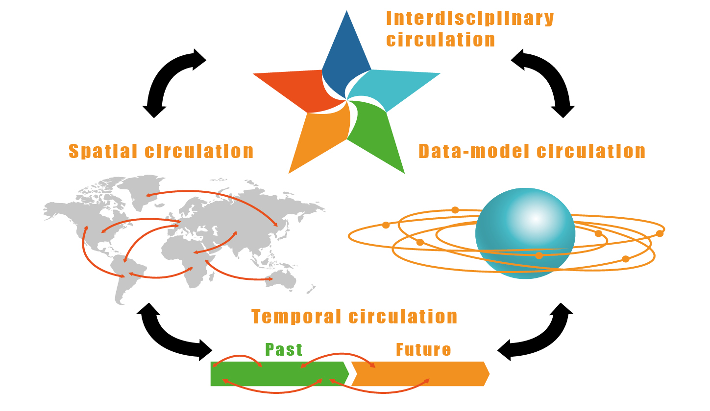
The study shows that over the past 30 years, the researchers who have carried out their work in the PAGES program, regardless of their discipline, are first and foremost recognized in their efforts in developing multiple forms of "circulation" between knowledge, skills, and data. Circulation is a modality of knowledge production within scientific disciplines (or between disciplines) in which the progress of scientific understanding depends on the comparison of singular cases that are never completely reducible to each other (Ogorzelec-Guinchard 2021).
 |
|
Figure 1: Forms of circulation identified and promoted within the PAGES network. |
The first form of circulation is found in the highly heterogeneous, yet complementary, nature of the data and proxies used to study past global change. The second form of circulation covers the spatial dimension of research. To understand the functioning and dynamics of the climate system, it is necessary to collect and articulate data from all regions of the world, even if each region remains marked by its own particularities.
A third form of circulation, between observations and models, characterizes the research within PAGES. This form of circulation can be two-way, seeking either the interpretation of data through a functional model, or a "path of reference" (Latour 1995), returning to the field where the data were collected, to apply a predictive model. Finally, the "paleo" approach is characterized by a temporal circulation of knowledge between past and present. This fourth form of circulation offers a perspective on contemporary climatic and environmental changes by placing them in historical context to make them more intelligible.
The originality of the PAGES project lies in these multidimensional exchanges, stemming from all the circulations, likely to bring out new ways in which societies think about their relationship to time, and to analyze how societies settle and unfold in time, especially in times of crisis (Hartog 2015). PAGES' aim is to reorder our experience of time to better understand contemporary changes, the role of societies in these changes, the climatic and environmental mechanisms at play, and to reduce the uncertainties associated with future projections as much as possible.
The forms of circulation (Fig. 1) discussed above are based on the ability of researchers to move between varied geographical and temporal contexts, and sometimes between very specific skillsets and disciplinary approaches. Bringing researchers from different scientific cultures together within working groups and around the same problem forms an arrangement of "distributed cognitions" (Hutchins 1995) and a network of intelligence. Studies of the interactions between natural systems and social systems certainly call for the expansion of these working groups and networks, and for a better understanding of how to manage them.
The ability to create bridges between many different experiences and disciplinary concepts is akin to creating new neural connections that can lead to the emergence of real and original knowledge. As one of the former directors of the program put it: "My own experience was actually: if you go to a workshop, and you are exposed to other people, other ideas, other perspectives – provided that they are well communicated, so you understand something – as this is very inspiring. And I heard this million times of people feel inspired. Purely by being exposed to something new builds new synapses."
Finally, an extension of these types of circulation outside the paleo network is expressed in the dissemination of scientific works resulting from all of PAGES' activities to the wider academic world, and beyond. The interviews conducted showed that this extension, which consists of exchanges with actors outside the network, should be a priority for the researchers. This transfer deserves to be a priority, because it is through this knowledge exchange with the non-academic world, public and decision-makers, that the research objectives are enriched and made more meaningful.
The full report from this internship (in French) can be accessed at pastglobalchanges.org/publications/128532. We do not claim to have thoroughly analyzed PAGES' history, but this report sheds light on the challenges that have been faced by the PAGES program over the last 30 years. PAGES, in stimulating and facilitating these different forms of "circulation", responds effectively to the scientific and political challenges posed by the environmental and climatic crisis we are currently experiencing.
affiliationS
1MSHE, CNRS, Université Bourgogne Franche-Comté, Besançon, France
2University of Paris-Saclay, France
contact
Laetitia Ogorzelec: laetitia.ogorzelecuniv-fcomte.fr
references
Hutchins E (1995) Cognition in the Wild. MIT Press, 402 pp
Latour B (1995) Common Knowledge 4: 145-187
Ogorzelec-Guinchard L (2021) Des bibliothèques contre l'incertitude. L'Harmattan, 216 pp
Philip E. Higuera![]() 1, S. Crausbay
1, S. Crausbay![]() 2, B. Shuman
2, B. Shuman![]() 3 and K. Wolf
3 and K. Wolf![]() 4
4
Unprecedented conditions in Rocky Mountain subalpine forests challenge contemporary approaches to forest restoration, requiring deep thinking across the science–management spectrum. Paleoecology can contribute to this endeavor by contextualizing ongoing change and revealing how ecosystem transformations unfolded in the past.
Fire and anthropogenic climate change in Rocky Mountain subalpine forests
Anthropogenic climate change is enabling increased fire activity across western North American forests by increasing fuel aridity (Abatzoglou and Williams 2016). Fire intensity and spread in dry fuels is more extreme, especially in high-wind conditions, evading fire control and often resulting in greater human and ecological impacts.
The pattern of increased burning is particularly evident in subalpine forests of the western US (Alizadeh et al. 2021). Subalpine forests are high-elevation, conifer-dominated ecosystems that span the ca. 1000 m just below treeline, across the Rocky Mountains. Wildfires have shaped subalpine forests for millennia, but emerging interactions among climate, fire, and society are transforming these fire-prone social-ecological systems.
Historically, fire in subalpine forests was limited by high fuel moisture and only occurred in unusually warm, dry conditions, with mean fire-return intervals of one to several centuries (e.g. Higuera et al. 2021). Contemporary climate change is promoting fire in subalpine forests by increasing the frequency and intensity of drought, making fuels dry enough to burn more frequently (Alizadeh et al. 2021).
Uncharted territory: subalpine forests now burning more than any time in recent millennia
After extraordinary burning across the western US in 2020 (Higuera and Abatzoglou 2021), we suspected that climate change may have pushed contemporary burning beyond the longstanding range of variability experienced in some Rocky Mountain subalpine forests.
 |
|
Figure 1: Northern Hemisphere climate history (from Mann et al. 2009) and subalpine forest-fire history from 20 lake-sediment records spanning a 30,000-km2 region in northern Colorado and southern Wyoming (Higuera et al. 2021). The red line reflects the fire rotation period, equivalent to the average time between fires at any one lake, or mean fire return interval. Red diamonds reflect contemporary burning in the study region. Figure reused under CC license from TheConversation.com, modified from Higuera et al. (2021). |
We tested this hypothesis using a unique network of 20 paleofire records within a 30,000-km2 study region in northern Colorado and southern Wyoming. We found that subalpine forests in the 21st century are now burning twice as often as they have over the past two millennia: estimated mean fire return intervals are now 117 yr compared to an average of 230 yr over the past two millennia (Fig. 1; Higuera et al. 2021). Additionally, the 21st-century rate of burning (e.g. area burned per unit time) is over 20% higher than the maximum rate estimated over the past two millennia, which occurred during the early Medieval Climate Anomaly (MCA; 770 to 870 CE), when Northern Hemisphere temperatures were ∼0.3°C above the 20th-century average (Mann et al. 2009). The paleofire record thus highlights that 21st-century climate change has enabled fire activity that exceeds the range of variability that shaped these ecosystems for millennia (Fig. 1). We are clearly in uncharted territory.
Core insights from paleoecology in Rocky Mountain subalpine forests
The rich network of paleorecords in Rocky Mountain subalpine forests, including climate, fire, and vegetation histories, highlight three themes relevant to understanding contemporary change and informing forest-management decisions.
First, fire itself is not novel in these systems; rather, it is the frequency of burning that is unusual. For millennia, subalpine forests experienced high-severity wildfires—killing most trees—once every one to several centuries. Holocene pollen, geochemical, and charcoal data indicate that vegetation and ecosystem properties recovered in the decades after wildfire, exhibiting resilience to individual fire events (Minckley et al. 2012; Dunnette et al. 2014).
Second, paleorecords bolster our contemporary understanding of the climate controls of fire in subalpine forests. Tree-ring research reveals widespread burning during years of unusually warm, dry conditions in Colorado subalpine forests (Sibold and Veblen 2006), and lake sediments studies from the same region show that fire activity varies with centennial-scale climate variability (Calder et al. 2015; Higuera et al. 2021; Fig. 1).
Finally, the paleorecord reveals just how rarely wildfires caused state changes in the past, in subalpine forests and beyond (e.g. Crausbay et al. 2017), mainly when changes in climate and fire jointly drove ecosystem transformation. For example, extensive burning in northern Colorado during the MCA transformed some subalpine forests to "ribbon forests", narrow bands of trees separated by subalpine meadow communities. This lower tree density and forest extent was maintained afterwards by snowier conditions of the Little Ice Age (ca. 1400–1700 CE, Mann et al. 2009), and still persists today (Calder and Shuman 2017).
With 21st-century climate change accelerating beyond the bounds of the past, we expect that events that were exceptional in the paleorecord will become increasingly common, altering the trajectory of ecosystems and their longstanding resilience to wildfires.
Challenges to ecological restoration
Climate change and increased area burned across western US forests adds urgency to the need for ecological restoration in many ecosystems. Ecological restoration is defined as the "process of assisting the recovery of an ecosystem that has been degraded, damaged, or destroyed" (Society of Ecological Restoration (SER); ser-rrc.org/what-is-ecological-restoration). While the concept of recovery is central, the goal is to "return a degraded ecosystem to its historic[al] trajectory, not its historic[al] condition" (emphasis added). The emphasis on trajectories acknowledges non-stationarity (e.g. past climate variability), orienting restoration targets towards what an ecosystem would be like today in the absence of past degradation, damage, or destruction.
 |
|
Figure 2: Managers face challenges that require understanding both the probability of ecological transformation and the acceptability of such changes. The "resist, accept, direct" framework can help decision making when transformation is (C, D) likely or (A) desirable; when transformation is (B) unlikely and undesirable, restoration goals remain appropriate and feasible. Modified from Higuera et al. (2019). |
The goal of restoring past dynamics and trajectories is clearly applicable to many low-elevation forests across the western US, which, unlike subalpine forests, historically burned frequently in low-severity surface fires (e.g. mean fire return intervals < 10-50 yr). In these forests, fire suppression, policies preventing Indigenous fire stewardship, and high-grade logging since the 19th century have altered forest structure and composition (Hessburg et al. 2019). Restoration efforts here thus focus on reducing tree biomass and retaining thick-barked, fire-resistant species that dominated prior to fire suppression, to help ultimately reintroduce and sustain frequent low-severity fires.
Similar changes in tree density and composition are not as prevalent in subalpine forests, due to their historically long fire-free intervals (Fig. 1) and more limited land uses. Yet, contemporary climate change is increasingly altering disturbance regimes and ecological trajectories in these forests beyond the historical range of variability, even in the absence of past damage or degradation (Turner et al. 2019; Higuera et al. 2021). The combination of increased burning and warmer, drier post-fire conditions in subalpine forests requires a management framework that is more forward-looking in time, relative to the goal of ecological restoration.
Navigating uncharted territory
In a world experiencing rapid climate change, realigning ecosystems with historical trajectories may be inconsistent with expectations of climate-driven ecological change. The resist–accept–direct (RAD) framework has been developed to guide natural resource management when ecological transformation is likely (Schuurman et al. 2022). The RAD framework identifies three management responses to ecological transformation: resist, accept, or direct ecological trajectories. This adds options to the restoration-oriented goal of realigning systems with historical trajectories (Fig. 2). Paleoecology provides the long lens needed to contextualize contemporary ecological trajectories, and help inform choices among different RAD options if transformation is inevitable.
For example, the combination of climate change and increased burning in subalpine forests, now outside the range of variability in our study area (Fig. 1), suggests the likelihood of fire-catalyzed ecological transformation is high. Are there areas where dispersing seeds or planting seedlings in high-severity patches would help managers resist future forest loss, given reduced natural tree regeneration under warmer, drier conditions? Would planting different species help direct the ecological trajectory to a new community, with trees better adapted to future conditions? Or, are managers and stakeholders willing to accept the post-fire ecological trajectory, yet unknown and possibly novel, with minimal intervention?
Deciding among RAD options is complex and multidimensional, because consequences are social, cultural, and institutional, as well as ecological. Science that provides a better understanding of the likelihood of ecological transformation (i.e. x-axis in Fig. 2) is an important starting point for RAD decision-making (Crausbay et al. 2022), but assessing the acceptability of change (i.e. y-axis in Fig. 2) requires community input and extends beyond the science of ecology (Higuera et al. 2019).
Conclusions
Paleoecology is particularly well poised to inform RAD decision-making because the long historical perspective can help assess if, and when, contemporary conditions are unprecedented, and, thus, if transformation is likely. Paleoecology also offers opportunities to learn from past ecological change (Nolan et al. 2018), and hone in on the triggers, rates, and ecological trajectories that characterize the process of transformation. Integrating paleoecological knowledge with processes for making RAD decisions will be increasingly relevant when ecological restoration is not possible.
affiliations
1Department of Ecosystem and Conservation Sciences, University of Montana, Missoula, USA
2Conservation Science Partners, Fort Collins, CO, USA
3Department of Geology and Geophysics, University of Wyoming, Laramie, USA
4Systems Ecology Graduate Program, University of Montana, Missoula, USA
contact
Philip Higuera: Philip.Higueraumontana.edu
references
Abatzoglou JT, Williams AP (2016) Proc Natl Acad Sci USA 113: 11770-11775
Alizadeh MR et al. (2021) Proc Natl Acad Sci USA 118: e2009717118
Calder WJ et al. (2015) Proc Natl Acad Sci USA 112: 13261-13266
Calder WJ, Shuman B (2017) Ecology 8: 2585-2600
Crausbay SD et al. (2017) Ecology 98: 2356-2369
Crausbay SD et al. (2022) Bioscience 72: 71-90
Dunnette PV et al. (2014) New Phytol 203: 900-912
Hessburg PF et al. (2019) Front Ecol Evol 7: 239
Higuera PE et al. (2019) Bioscience 69: 379-388
Higuera PE, Abatzoglou JT (2021) Glob Chang Biol 27: 1-2
Higuera PE et al. (2021) Proc Natl Acad Sci USA 118: e2103135118
Mann ME et al. (2009) Science 326: 1256-1260
Minckley TA et al. (2012) Ecol Monogr 82: 49-68
Nolan C et al. (2018) Science 361: 920-923
Schuurman GW et al. (2022) Bioscience 72: 16-29
Sibold JS, Veblen TT (2006) J Biogeogr 33: 833-842
Turner MG et al. (2019) Proc Natl Acad Sci USA 116: 11319-11328
Matthew A. Adeleye![]() 1,2, S.E. Connor
1,2, S.E. Connor![]() 1,2, S.G. Haberle
1,2, S.G. Haberle![]() 1,2 and P.A. Adeonipekun
1,2 and P.A. Adeonipekun![]() 3
3
Using a paleoecological approach, we reveal that recent human activities, rather than natural variations in climate, have caused the greatest changes to Nigerian forests in the last 7000 years. Savanna has shown an even higher climate sensitivity in the past and will likely experience significant changes based on projections of future climate change.
Background
Ecosystem management and conservation challenges are acute in developing nations—including many African countries—as a result of widespread poverty, population growth, and heavy reliance of people on ecosystems for a living (Watson et al. 1997). Nigeria (Fig. 1), which is one of Africa's biodiversity hotspots (Küper et al. 2004), not only has the largest population of any African country (over 200 million), but also the highest number of people living in extreme poverty globally (fao.org; worldpoverty.io). While pervasive human impacts (e.g. agriculture, deforestation, pollution) are the major causes of ecosystem degradation in Nigeria (fao.org), the ecosystems in the region have also been impacted by recent climate changes (Ikumbur and Iornumbe 2019). Understanding the magnitude of ecosystem response (i.e. species turnover) to past climate change and land use can help identify which ecosystems require protection and which areas require urgent conservation/restoration.
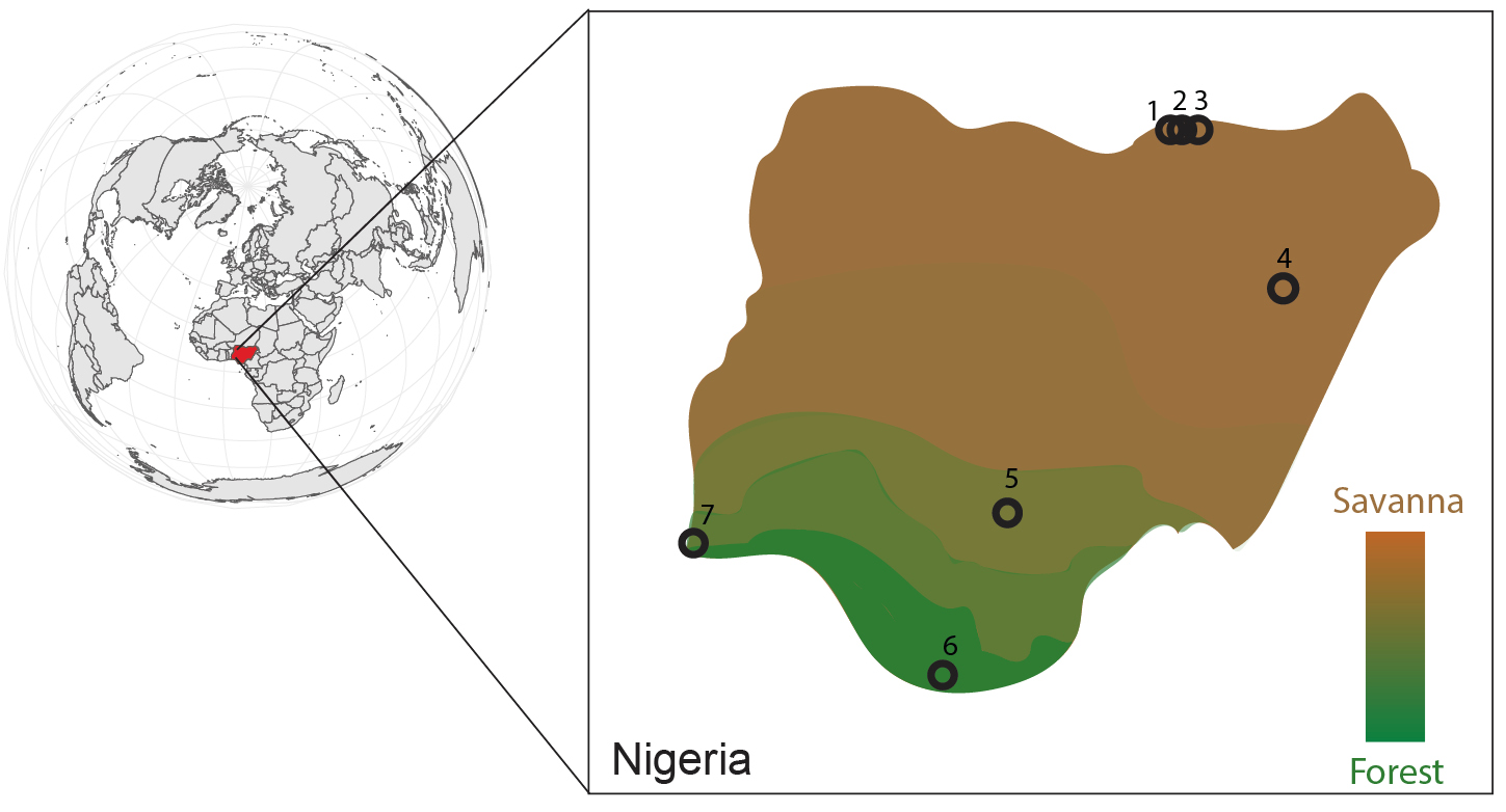
Paleoecological records provide reliable ecosystem baseline data for setting conservation, restoration, and management goals (Wingard et al. 2017). This is because paleoecological datasets describe ecosystem patterns and processes over centuries and millennia, which can then be used to develop effective frameworks and strategies for ecosystem interventions (Wingard et al. 2017). However, current baseline data are insufficient in Nigeria to contextualize the long-term regional ecosystem patterns in response to past changes in climate and land use (Eneh 2011). Adeleye et al. (2021a) have used paleoecological datasets to detail the temporal magnitude of vegetation compositional change (turnover) in Nigeria and surrounding western African regions over the last 10,000 years in response to past changes in climate and land use. Here, we compare past turnover in forest and savanna with current rates of change and highlight what the differences mean for ecosystem restoration in the country. To understand the history of present-day ecosystems, we examined Holocene datasets spanning the last 7000 years.
 |
|
Figure 1: A generalized representation of vegetation distribution in Nigeria and site locations of pollen records used in this article (black circles). Savannas (brown) include Sahel, Sudan, and Guinea types. Forests (green) include lowland rainforest, deciduous forest, freshwater swamp forest and mangrove forest. Pollen records spanning the last 7000 years include Bal Lake (1), Jikariya Lake (2), Kajemarun Oasis (3), Tilla Lake (4), Ohe Pond (5), Ofuabo Creek (6), and Badagry Creek (7). See Adeleye et al. (2021a) for more details regarding the pollen records. |
Magnitude of change in Nigeria's forest and savanna
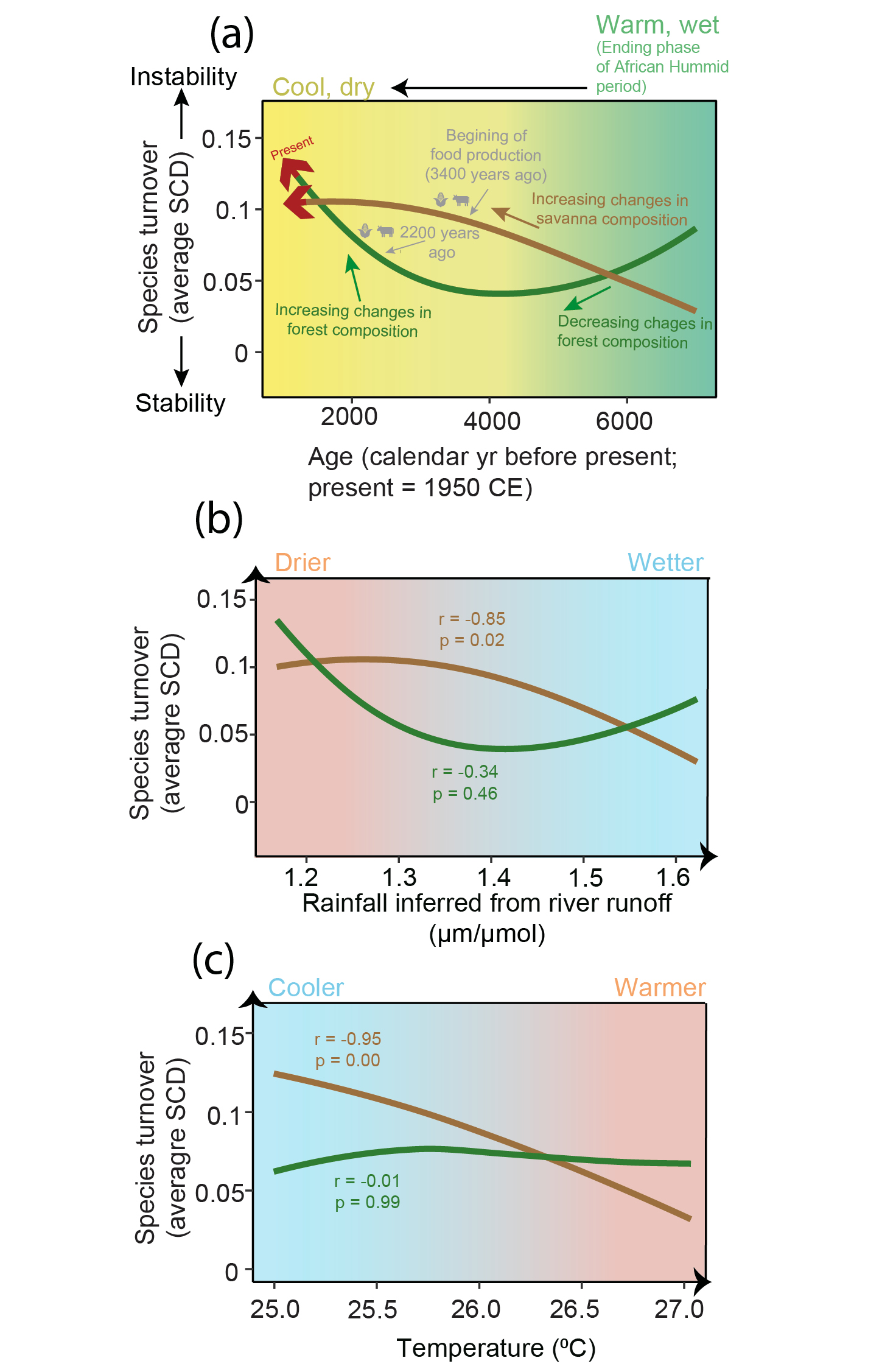
Adeleye et al. (2021a) found that vegetation in many areas of western Africa, including the sites indicated in Figure 1, experienced accelerated turnover in the last 7000 years in response to both climate change and intensified land use. Focusing on records only from Nigeria, savanna in northern Nigeria experienced the overall greatest turnover in the last 7000 years; in contrast, forests in southern Nigeria were relatively stable prior to 2000 years ago (Fig. 2a). A significant (p < 0.05) link between savanna turnover and changes in rainfall and temperature suggests long-term sensitivity of savanna to past climate change, with greatest turnover occurring after the termination of the African Humid Period around 6000–5000 years ago, when conditions became drier and cooler than before. The fact that forest showed little turnover in response to these decreases in precipitation and temperature suggests that forests exhibited long-term resilience (minimal changes in species composition) to past climate changes (Fig. 2a-c). It is also possible that the exploitation of northern Nigerian savanna for food production from ∼3400 years ago contributed to rapid changes in savanna composition during this period (Kay et al. 2019). Food production expanded in southern Nigeria from ∼2200 years ago and would have also contributed to high forest turnover in the last 2000 years (Kay et al. 2019).
Arid to semi-arid terrestrial ecosystems have been identified as susceptible to future climate changes (Watson et al. 1997), and increases in temperature and declines in rainfall have been predicted for northeastern Nigeria (Shiru et al. 2020), where most of the savanna pollen sites are located (Fig. 1). Our paleoecological results show that Nigeria's savanna was sensitive to past rainfall declines after the end of the African Humid Period when the climate was also becoming cooler (Fig. 2b-c). This drought promoted grassland communities (Adeleye et al. 2021a). Considering the current impact (desertification) of warm, dry conditions in Nigeria's savanna (Olagunju 2015), projected climate change will likely intensify drought and its impacts (e.g. species mortality, longer recovery time, shifts in species range) on both grassland and non-grassland communities, leading to further desertification (Sankaran 2019). The increasing trend of intensive agriculture in northern Nigeria may also exacerbate the impact of climate change by suppressing native species recovery after extreme drought events/episodes. This combination seems likely to cause the savanna to enter novel states with greater turnover than anything that has been observed in the last 7000 years (Sankaran 2019; Olagunju 2015).
 |
|
Figure 2: (A) 7000-yr record of plant species turnover (average Squared Chord Distance (SCD) between adjacent pollen samples) in northern Nigerian savanna (brown line) and southern Nigerian forest (green line) in relation to past changes in climate and land use (adapted from Adeleye et al. 2021a and Kay et al. 2019). SCD is a measure of dissimilarity between samples (pollen spectrum). (B, C) Smoothed curves of turnover–climate relationships, with correlation test results. See Adeleye et al. (2021a) for climate data sources, and Adeleye et al. (2021b) for details on SCD calculation. |
In contrast to earlier time periods, the last two millennia show highest species turnover in forests, compared to savanna (Fig. 2a). This agrees with modern vegetation mapping and surveys in Nigeria by Abbas et al. (2018), which indicate that forest ecosystems are rapidly changing, and shrinking faster than savanna at 9% and 4%/yr, respectively. Climate change may contribute to recent forest turnover in Nigeria, but the stability of the forests over the last 7000 years in the face of cooling and drought likely indicate that humans were responsible for forest decline and secondary-forest regrowth, especially in the last 2000 years (Kay et al. 2019). Human population density is currently highest in southern Nigeria in rainforest areas, and poverty-related agricultural practices, logging, mining, pollution, and urbanization are known to be causing forest loss and degradation in the region (Abbas et al. 2018; Fasona et al. 2018). Human impacts have likely resulted in major changes in forest composition in southern Nigeria (Fauset et al. 2012), and growing human population pressure will only further exacerbate biodiversity loss and widespread forest replacement through the introduction of novel anthropogenic vegetation.
Implications for ecosystem restoration in Nigeria
The results derived from paleoecological data presented here provide an understanding of long-term resilience and sensitivity of Nigeria's vegetation to drought and human impacts, and this information can assist us in identifying areas of restoration and conservation priority in the country. Our results suggest that recent human land use, rather than natural climate variations, has caused the greatest changes that the southern Nigerian forests have experienced in the last 7000 years. Therefore, effective forest conservation strategies will necessarily involve priority protection from deleterious human land use, especially agriculture, logging, and industrialization, to maintain/increase resilience in existing forest reserves and restore resilience in affected areas. Conversely, climate-sensitive savannas in northern Nigeria should be closely monitored for warning signs of climate-change impacts. Slowing down the rate of savanna transformation may require more complex and carefully designed ecological strategies that go beyond the reduction of intensive agriculture, to consider the high sensitivity of the ecosystem to drought. For instance, conservation strategies should involve a good understanding of savanna ecosystem dynamics across multiple temporal and spatial scales in savannas (Osborne et al. 2018). In addition, any management actions in Nigeria need to take into account their potential impacts on local stakeholders, since conservation gains cannot be sustainable if they come at the cost of human livelihoods.
affiliations
1School of Culture, History and Language, Australian National University, Canberra, Australia
2Australian Research Council Centre of Excellence for Australian Biodiversity and Heritage, The Australian National University, Canberra, Australia
3Department of Botany, University of Lagos, Akoka, Nigeria
contact
Matthew A. Adeleye: matthew.adeleyeanu.edu.au
references
Abbas II et al. (2018) MOJ Eco Environ Sci 3: 197-205
Adeleye MA et al. (2021a) Holocene 31: 1681-1689
Adeleye MA et al. (2021b) Glob Ecol. Biogeogr 30: 557-571
CBD-UNEP—Convention on Biological Diversity and United Nations Environment Programme (2018)
Eneh OC (2011) J Environ Sci Technol 4: 250-263
Fauset S et al. (2012) Ecol Lett 15: 1120-1129
Ikumbur B, Iornumbe S (2019) Niger J Environ Sci Technol 3: 268-291
Kay AU et al. (2019) J World Prehist 32: 179-228
Küper W et al. (2004) Ann. Missouri Bot Gard 91: 525-535
Osborne CP et al. (2018) New Phytol 220: 10-24
Olagunju TE (2015) J Ecol Nat 77: 196-209
Shiru MS et al. (2020) Sci Rep 10: 10107
Janet M. Wilmshurst![]() 1,2 and Jamie R. Wood
1,2 and Jamie R. Wood![]() 1
1
Pollen and ancient DNA from coprolites and peat reveal new and surprising insights about past pollination, herbivory, and native/alien status in New Zealand. These paleoecological findings help in understanding ecosystem structure and function before human arrival, informing current conservation, restoration, and management issues.
Oceanic islands have been transformed by forest clearance, extinctions, and invasive species following human arrival, leading to the creation of novel ecosystems (Wood et al. 2017; Nogué et al. 2021). This creates challenges for the management of current ecosystems, particularly if only relatively short-term ecological and historical observations are available to estimate what is "natural" on the landscape today (Willis and Birks 2006).
Paleoecology provides a longer-term perspective, and a more scientifically informed and defensible basis for biodiversity management decisions (Willis et al. 2007). Increasingly, paleoecological studies are providing new insights on ecological networks and interactions (e.g. pollination, seed-dispersal, and herbivory), function, and resilience (Dietl 2015), which can increase our understanding of current ecosystems and inform their management (Willis et al. 2007; Johnson et al. 2017). This is important in restoring degraded ecosystems where critical ecological functions have been disrupted.
As with many islands, initial human settlement of New Zealand ca. 1280 CE saw fundamental changes to ecosystems, largely through deforestation by fire and the rapid demise of its bird-dominated fauna (Perry et al. 2014a; Perry et al. 2014b; Wood et al. 2017). Here we showcase three examples from New Zealand where pollen and ancient DNA analyses of coprolites and peat have expanded our understanding about ecological processes and interactions and contributed to debates about contemporary conservation issues, including restoration of pollination, management of herbivores and establishing the native versus alien status of species.
 |
|
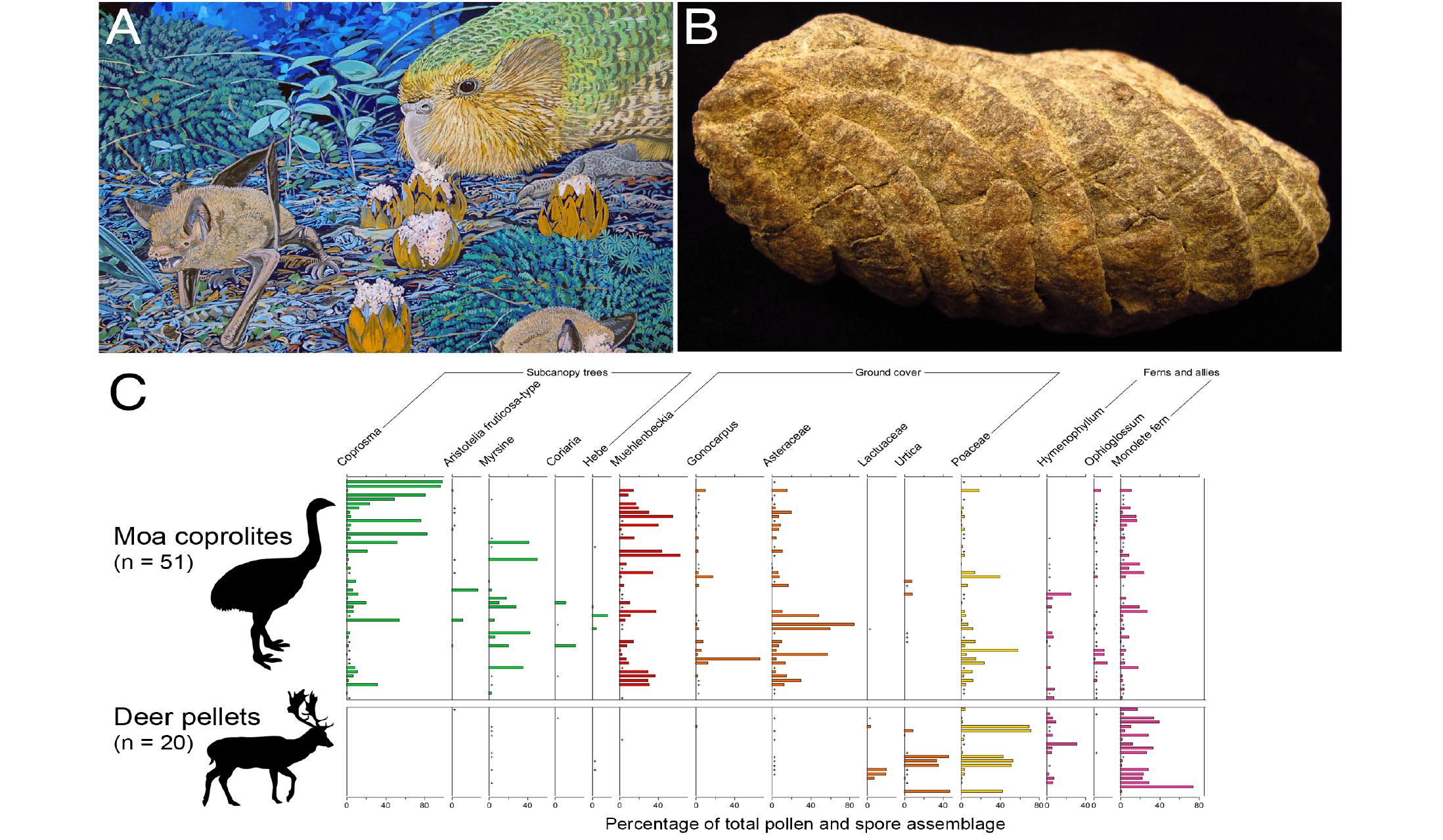
Figure 1: (A) Kākāpō (Strigops habroptila) and lesser short-tailed bats (Mystacina tuberculata) consuming nectar from Dactylanthus taylori flowers (from Wood et al. 2012: Artwork credit: Chris Gaskin); (B) Moa coprolite, Dart River Valley, New Zealand (photo credit: J.M. Wilmshurst); (C) Comparison of relative pollen abundance from selected forest understorey plant taxa recorded in individually sampled moa coprolites and deer pellets from Dart River Valley (modified from Wood & Wilmshurst 2019). Deer silhouette by Anthony Caravaggi (CC BY-NC-SA 3.0; creativecommons.org/licenses/by-nc-sa/3.0). |
Restoring ecological interactions: analysis of coprolites uncovers lost pollinators
New Zealand's endemic and threatened Dactylanthus taylori is a cryptic root parasite of hardwood trees and shrubs. Its current range is vastly reduced from its prehuman distribution, due to forest clearance and browsing from introduced possums (Trichosurus vulpecula) and rats (Rattus rattus and R. norvegicus) (Ecroyd 1996). The flowers, the only part of the plant to emerge above ground, produce copious, highly scented, and sticky nectar. The only documented pollinator is the lesser short-tailed bat (Mystacina tuberculata), which forages on the forest floor like a mouse (Fig. 1a). This species is also threatened and it's pre-human distributional range has become greatly reduced in area and highly fragmented (Ecroyd 1996). As Dactylanthus no longer co-occurs with the short-tailed bat in many places, pollination limitation provides a challenge to its conservation (Holzapfel 2005). However, Wood et al. (2012) made a surprise finding of Dactylanthus pollen preserved in a 900-year-old coprolite, which ancient DNA showed as belonging to kākāpō (Strigops habroptila), a threatened, flightless nocturnal parrot (Fig. 1a). This result suggested ground feeding and nectar drinking birds (many now extinct or rare because of mammalian predators) may also have once pollinated Dactylanthus. This new insight now means that besides promoting conditions for the pollinating bat Mystacina tuberculata, establishing Dactylanthus on predator-free islands with nectivorous birds is a possible solution for overcoming pollination limitation in the conservation of this rare plant.
Reconstructing past diets of extinct herbivores to inform current management of introduced herbivores
Before human arrival in New Zealand, the ratite moa were the largest of the terrestrial herbivores. Pollen, macrofossil, and ancient DNA studies of their distinctive coprolites (Fig. 1b) show that these birds browsed widely on trees, shrubs, climbers, herbs, forbs, and ferns (Wood et al. 2020). The extinction of all nine moa species by ca. 1450 CE left the large herbivore niche vacant. The introduction of ungulates from the late 1700s to early 1900s CE, including deer and goats, restored this large herbivore guild to New Zealand. However, there is ongoing debate about whether ungulate browsing is functionally equivalent to moa browsing (Wood and Wilmshurst 2017).
In 2006, coprolites (Fig. 1b) were discovered beneath a rock overhang in the remote Dart River Valley in southern New Zealand. DNA analysis and radiocarbon dating showed that they had been deposited by four different species of moa between 1,000 and 600 years ago (Wood and Wilmshurst 2019). This find was important for two reasons. First, it was within an area of relatively "natural" beech (Nothofagaceae) forest not directly modified by humans. Second, deer pellets beneath the overhang allowed a direct comparison between the diets of moa and deer. The moa coprolites contained a far greater richness of pollen types than deer pellets (Fig. 1c), suggesting that pressure from deer browsing is higher than that of moa browsing, and that deer have depleted the forest understorey of many species (Wood and Wilmshurst 2019). Many palatable plants that were common in the moa coprolites are now only found growing on the tops of enormous boulders which are inaccessible to deer. Pollen analysis of high-resolution radiocarbon dated soil cores from other relatively unmodified forests show that forest understoreys appeared to change little following moa extinction in the absence of deer (Wood and Wilmshurst 2017). These new insights from the past offer a growing scientific basis on which comparisons between extinct and introduced herbivores can be made. There is now little doubt that ungulates need to be managed to keep them at low numbers if vegetation structure and diversity similar to the past is to be maintained.
 |
|
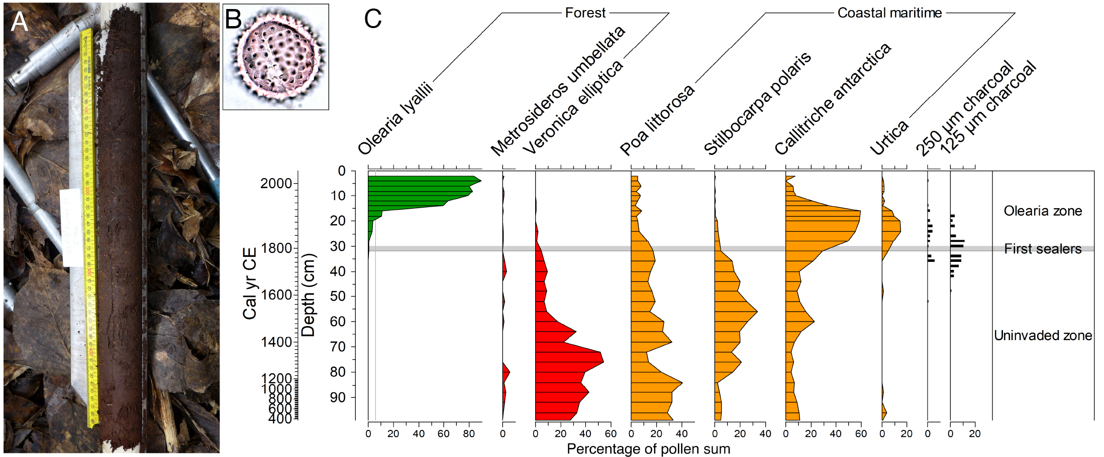
Figure 2: (A) Peat core from under Olearia lyallii canopy, northern Auckland Islands; (B) O. lyallii pollen; (C) Summary pollen and charcoal record from the northern Auckland Islands showing the recent arrival and establishment of O. lyallii coinciding with sealing gangs on the islands, modified from Wilmshurst et al. (2015). |
Using paleoecological records to confirm the status of an alien tree on subantarctic Islands
The longer-term perspective provided by paleoecological records (such as pollen, ancient DNA, and faunal remains in sediments or coprolites) can show if a species is native or alien and can inform decisions over whether control is needed. Wilmshurst et al. (2015) combined long-term paleoecological records from peat cores with historical photographs and documents to resolve the status and origin of a New Zealand native tree daisy (Olearia lyallii) growing on the subantarctic Auckland Islands, located about 450 km south of the main islands of New Zealand. The highly localized distribution of O. lyallii on the Auckland Islands was first noted in 1840, and its appropriate management is debated: should it be regarded as an alien invasive and controlled, or acknowledged as a native species in the Auckland Islands flora? Radiocarbon-dated pollen records from northern Auckland Islands showed that O. lyallii was likely absent until 1807–1810 CE (Fig. 2), which is when European sealing gangs arrived on the Auckland Islands for a brief period of seal exploitation. Sealers working on seabird islands at this time about 270 km to the north, where O. lyallii is naturally dominant, most likely transported the dry feathery seeds on their clothes or equipment to the Auckland Islands during this period. Pollen and charcoal records revealed that O. lyallii populations established and thrived in disturbed coastal areas burnt by the sealers (fig. 2). O. lyallii growth was enhanced by nesting seabirds and recovering seal populations using these sites, as the marine nutrients they provided replicated the situation on seabird islands in their natural range. This finding provided conservation managers with a scientifically informed basis to manage O. lyallii as an alien on the Auckland Islands.
Final remarks
Paleoecology can provide critical guidance for conservation management and restoration, especially in situations where other historical information or long-term ecological studies are lacking. It is therefore particularly well suited for recently settled or remote (e.g. oceanic islands) locations. However, even in ecosystems considered well-understood, it can add another dimension by revealing surprising new insights and interactions. The information can be applied in the context of functional re-wilding, herbivore management, and the control of alien species.
affiliations
1Manaaki Whenua – Landcare Research, Lincoln, New Zealand
2School of Environment, University of Auckland, New Zealand
contact
Janet M. Wilmshurst: wilmshurstjlandcareresearch.co.nz
references
Dietl G et al. (2015) Ann Rev Earth Planet Sci 43: 79-103
Ecroyd CE (1996) N Z J Ecol 20: 81-100
Johnson CN et al. (2017) Science 356: 270-275
Nogué S et al. (2021) Science 372: 488-491
Perry GLW et al. (2014a) N Z J Ecol 38: 157-176
Perry GLW et al. (2014b) Quat Sci Rev 105: 126-135
Willis KJ et al. (2007) Philos Trans R Soc Lond B Biol Sci 362: 175-186
Willis KJ, Birks HJB (2006) Science 314: 1261-1265
Wilmshurst JM et al. (2015) AoB PLANTS 7: plv104
Wood JR et al. (2017) Environ Conserv 44: 348-358
Wood JR et al. (2020) N Z J Ecol 44: 1-21
Wood JR, Wilmshurst JM (2017) J Veg Sci 28: 160-171
Thomas Giesecke![]() 1, P. Kuneš
1, P. Kuneš![]() 2 and L.S. Shumilovskikh
2 and L.S. Shumilovskikh![]() 3
3
Paleoecological studies document that grasslands with a high conservation value in the European forest-steppe ecotone are often anthropogenically derived, requiring management to avoid woodland recovery. Nevertheless, naturally open areas often persisted within this ecotone, explaining the high richness of these grasslands.
The forest-steppe ecotone
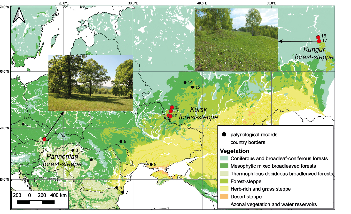
The European forest-steppe ecotone extends over 6000 km from the Carpathian to the Ural Mountains and is the natural transition from temperate broadleaf or mixed conifer forests to naturally open grasslands. Overall, this southeastern forest limit in Europe is determined by climate, while limiting parameters differ along its extent. The ecotone harbors many species-rich grasslands with high conservation value. At the same time, its Holocene history is not well documented, as indicated by the comparably small number of paleo studies in this region (Fig. 1).
The location, structure and composition of the ecotone likely changed through time as climate and land use changed over the course of the Holocene. Due to the fertile soils characterizing most of the region, it is extensively used for agriculture with few patches of natural vegetation remaining, and it is difficult to deduce the position of the ecotone based on modern observations. The transition zone may have consisted of a mosaic of forest and grasslands or uninterrupted open forest with a rich herb layer. Moreover, the mechanisms that maintained these semi-open forests or a forest grassland mosaic are not fully understood. Fires and grazing of large herbivores in combination with prehistoric land use may have shaped the structure in combination with geomorphology and local climate. Paleoecological investigations are paramount to uncover the natural position, structure, and disturbance regime to provide baselines needed for restoration efforts or management plans.
 |
|
Figure 1: Map of the European forest-steppe ecotone (Bohn et al. 2003), depicting selected pollen diagrams from forest-steppe areas with those mentioned in the text highlighted in red: (1) Zahájí (Pokorný et al. 2015); (2) Lake Vracov (Kuneš et al. 2015); sites 3 to 8 are summarized in Feurdean et al. (2021); (9) Zamostye (unpublished); (10) Sudzha (Shumilovskikh et al. 2019a); (11) Klukvennoe (unpublished); (12) Peny (unpublished); (13) Razdolye (unpublished); sites 14 and 15 are summarized in Shumilovskikh et al. (2018); (16) Viatkinskoe (Shumilovskikh et al. 2019b); (17) Krugloe (Shumilovskikh et al. 2021). |
Situated at the foothills of the Ural Mountains, the Kungur region is the northern-most outpost of the East European forest-steppe zone. The high biodiversity and endemics in today’s grasslands gave rise to two competing concepts describing the Holocene history of the Kungur forest-steppe. The “Pleistocene relict” concept suggests that a birch forest-steppe like those occurring in Siberia today prevailed in the region during the Pleistocene and persisted during the Holocene. The “anthropogenic” concept suggests that the Pleistocene steppe was replaced by hemiboreal forests with the onset of the Holocene, with steppe elements surviving along rivers and on exposed rocks. Deforestation led to the establishment of secondary birch and pine forests and the spread of steppe elements, as they are found today. Resolving this debate on the origin of the Kungur forest-steppe is one of the many examples of how a millennial-scale perspective can provide guidance on nature conservation and restoration.
A new pollen record documenting the vegetation composition in the Kungur region over the last 3400 years (Shumilovskikh et al. 2021) demonstrates that the landscape was largely covered by hemiboreal forests. The oldest samples dating to the Bronze age document the presence of humans, who created larger open areas using fire. At the end of this settlement phase, the forest recovered quickly. Nevertheless, periods with little disturbance don't have a complete forest cover. During these periods and possibly also during the Early and mid-Holocene, steppe vegetation was likely restricted to exposed gypsum formations with low water retention.
Deforestation after the Russian colonization in the 17th century led to the opening of the landscape as it is today. Thus, the generally open character of the landscape is relatively recent and of anthropogenic origin, providing new habitats for the spread of steppe species. Based on available paleoecological data, the "Pleistocene relict" hypothesis can be rejected regarding the overall openness and structure while individual steppe elements may have survived in specific habitats.
Information documenting the anthropogenic formation of open areas also comes from the middle Dniepr forest-steppe region (Kursk, Russia). The Sudzha and Klukvennoe pollen records indicate the dominance of broadleaf with oak until 200 years ago when the area was transformed into an agricultural landscape. Other sites within the region such as Zamostye, Peny and Razdolye (Fig. 1) show the presence of pine-dominated forests indicating a high heterogeneity in standscale forest composition.
High-resolution pollen diagrams for the last 1100 years from Peny show strong forest reduction in the 13th century (connected to the Kievan Rus), forest recovery during the Tatar–Mongol invasions in the 14th century, and subsequent deforestations in the 15th century (connected to the Grand Duchy of Lithuania). The last deforestation pulse occurred in the 17th century when the Tsardom of Russia erected the Belgorod defense line to protect the fertile chernozem soil region against invaders from the south. Studied records document that the forest-steppe in the Kursk region was converted into the agropastoral steppe by the end of the 17th century.
 |
|
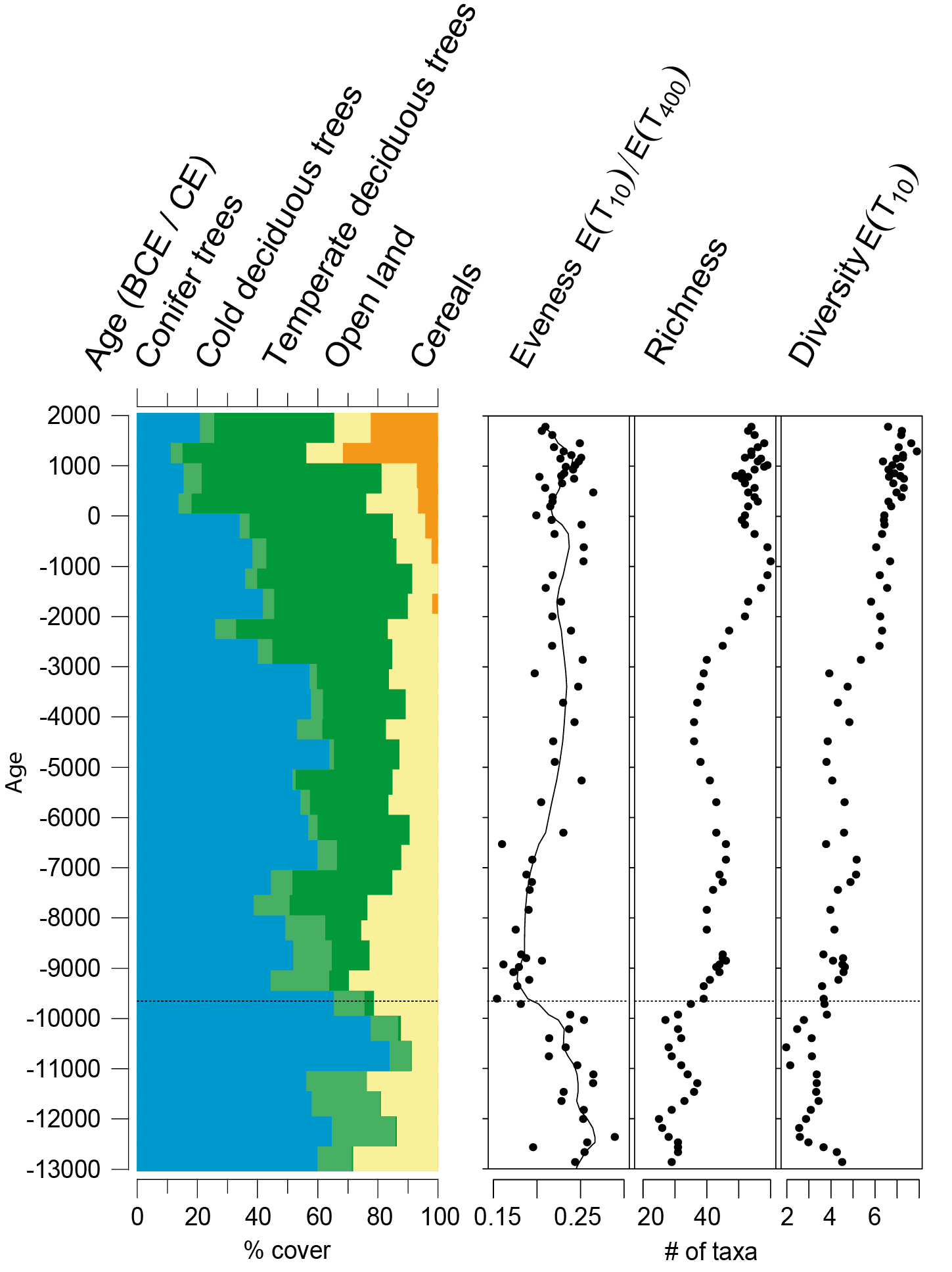
Figure 2: Pollen-based quantitative land-cover reconstruction for Lake Vracov (Kuneš et al. 2015). The ratio between forest area and open land was stable during the entire postglacial period. Reconstructed taxa are grouped into conifer trees (Abies, Juniperus, Picea, Pinus), cold deciduous trees (Alnus, Betula, Salix), temperate deciduous trees (Carpinus, Corylus, Fagus, Quercus, Tilia, Ulmus), open land (major herb taxa without cereals), and cereals. Pollen diversity and evenness are assessed based on the data of Svobodová (1992) following Matthias et al. (2015), and pollen-type richness is presented as a moving 4-sample taxa accumulation (Giesecke et al. 2014). |
Similar vegetation histories have been described for the western edges of the European forest-steppe ecotone. Here the prevailing hypothesis of an Early Holocene closed forest that was opened through human activity (Mitchell 2005) can be rejected using paleoecology. An interdisciplinary study of Lake Vracov at the western outcrops of the Pannonian Basin documents that open vegetation persisted from the Late Glacial into the Holocene (Kuneš et al. 2015; Fig. 2). In central and western Europe, the warming with the onset of the Holocene resulted in the spread of trees or increase in tree cover. This replacement of open vegetation types is visible in pollen diagrams as a decline in pollen-type richness (Giesecke et al. 2019). The data for Lake Vracov show the opposite trend of an increase in pollen-type richness at the onset of the Holocene.
Pollen-type richness and diversity can be interpreted as floristic richness and landscape diversity (Matthias et al. 2015); both increased at the onset of the Holocene at Lake Vracov. Richness and diversity further increased around 2000 BCE with the appearance of cereals, indicating the expansion of agriculture in the region. This example shows that although there was a continuation of open vegetation types, early land use further enhanced floristic richness and landscape diversity.
In addition to this example, the Holocene persistence of open land is documented in other lowland areas in this western region (Kuneš and Abraham 2017). Paleoecological information therefore support the hypothesis that the long-term stability of these ecosystems explains the existence of species-rich grasslands, with high conservation value, such as those in the Bílé Karpaty Mountains (Hájková et al. 2011).
Conclusions
The anthropogenic origin of many European open vegetation types is documented in a multitude of palynological studies. Also the forest-steppe ecotone was transformed by land use. While Neolithic to Iron age cultures reduced the forest cover of the ecotone somewhat, the transformation to a largely open agrarian landscape occurred only between 500 BCE in the Lower Danube region (Feurdean et al. 2021) and the 17th century in the Kungur forest-steppe (Shumilovskikh et al. 2019b, 2021). In eastern Europe, this deforestation likely shifted the ecotone to the North and West so that areas that are currently mapped as forest-steppe were forest-covered before extensive land-use started (Shumilovskikh et al. 2018).
Due to this transformation of the landscape, the cessation of agricultural activities would lead to a recovery of woodlands in most locations within the forest-steppe ecotone and a loss in the diversity of steppe associations over the medium-term. The open character of many vegetation types within the region depends on disturbance and conservation must therefore include disturbance factors in the form of selective felling, prescribed burning, moderate grazing, or traditional mowing.
affiliations
1Department of Physical Geography, Utrecht University, The Netherlands
2Department of Botany, Faculty of Science, Charles University, Prague, Czech Republic
3Department of Palynology and Climate Dynamics, University of Goettingen, Germany
contact
Thomas Giesecke: t.gieseckeuu.nl
references
Bohn U et al. (2003) Map of the Natural Vegetation of Europe. Landwirtschaftsverlag, 530 pp
Feurdean A et al. (2021) Biogeosci 18: 1081-1103
Giesecke T et al. (2014) Veg Hist Archaeobot 23: 217-228
Giesecke T et al. (2019) Nat Commun 10: 5422
Matthias I et al. (2015) J Ecol 103: 880-890
Hájková P et al. (2011) Preslia 83: 185-204
Kirschner P et al. (2020) Nat Commun 11: 1968
Kuneš P et al. (2015) Quat Sci Rev 116: 15-27
Kuneš P, Abraham V (2017) In Chytrý M et al. (Eds.) Flora and Vegetation of the Czech Republic, 1st ed. Springer, 193-227
Mitchell FJG (2005) J Ecol 93: 168-177
Shumilovskikh LS et al. (2018) J Veg Sci 29: 416-426
Shumilovskikh LS et al. (2019a) Veg Hist Archaeobot 28: 513-528
Shumilovskikh LS et al. (2019b) Rev Palaeobot Palynol 270: 1-7
Shumilovskikh LS et al. (2021) Biodivers Conserv 30: 4061-4087
Svobodová H (1992) The development of the southern Moravian vegetation in the Late Glacial and Holocene [in Czech]. Doctoral dissertation. Institute of Botany, CAS, Průhonice, Czech Republic
William P. Nanavati![]() 1,2, C. Whitlock
1,2, C. Whitlock![]() 3,4 and A. Holz
3,4 and A. Holz![]() 1
1
Two studies from the Patagonian forest-steppe ecotone (36–55°S; Argentina and Chile) demonstrate how interdisciplinary research combining paleoecological, archaeological, and historical methods provide information on past landscape conditions that can help prioritize conservation efforts and assess the likelihood of restoration success.
The forest-steppe ecotone in Patagonia (36–55°S; Argentina and Chile) is a striking vegetation transition between the dense forests of the Andes and the vast steppe of eastern Argentina (Fig. 1). On the western side of the ecotone, mesic forest is maintained by high levels of moisture and infrequent, moderate-to-high-severity fires, whereas on the eastern side, steppe prevails in a region of high seasonal or annual moisture deficit and frequent, low-severity fires (Kitzberger 2012). Decades of paleoecological and ecological research document past shifts in the position of the ecotone as a result of changes in climate and fire activity occurring over millennial to interannual timescales (Whitlock et al. 2007; Kitzberger 2012; Iglesias and Whitlock 2014). Superimposed on these broad-scale climate–vegetation–fire dynamics are the landscape-to-local-scale influences of ∼15,000 years of Native American land use and 200 years of Euro-American settlement, which have resulted in changes in site-specific vegetation, fuel loads, and fire regimes (Iglesias and Whitlock 2014; Holz et al. 2016; Nanavati et al. 2022).
 |
|
Figure 1: Map of southern South America (Chile and Argentina), showing generalized vegetation types and the ecotonal transition from wet, western forests to dry, eastern steppe. The locations of Laguna Portezuelo (Nanavati et al. 2020) and Río Rubens Bog (Huber and Markgraf 2003) are provided. |
The potential for landscape restoration depends on understanding the origins of the landscape condition, including the legacy of past climate and human activity (Gillson and Marchant 2014; Whitlock et al. 2018). Present landscape conditions lie along a gradient from minimally altered (or "nearly pristine") to mosaic to intensively altered (Fig. 2a); key to understanding ecosystem resilience within these landscapes is knowledge of antecedent climate variations, disturbance events, and land use.
In minimally altered landscapes, found in some national parks and other protected places, the influence of past climate change and indigenous land use on ecosystems cannot be easily disentangled. The assumption is that present ecosystem dynamics are operating within a range of variability shaped by climate–fire–human interactions that have not changed substantially through time. Paleoecological data, historical/ethnographic accounts, and ecological modeling are used to define an historical range of variability (HRV) for ecosystems in minimally altered landscapes, and this information establishes a baseline for restoration (Keane et al. 2009). Although ecosystems are expected to respond similarly to present-day disturbances as they have in the past, this assumption will be challenged given the novelty and uncertainty of future climate conditions (Williams 2021). Management objectives for minimally altered landscapes are, thus, commonly to monitor and protect ecosystems from new or extreme disturbances that may signal a shift in frequency, severity, or seasonality from HRV conditions. (Fig. 2a).
At the other end of the spectrum, intensively altered landscapes have been measurably shaped by past land use through, for example, the loss of native biodiversity, changes in long-term fire regimes, and/or depletion in soil fertility. These ecosystems are often less sensitive to climatic or extreme disturbance events than those in more intact landscapes, and management objectives frequently support cultural values or commodity needs. Restoration of intensively altered landscapes to a minimally altered state requires an extensive and sustained effort and may be economically or tactically impractical considering current socioeconomic realities and future climate and development pressures. Along the Patagonian forest-steppe ecotone, among the most intensively altered landscapes are Pinus plantations, which have been planted for commercial use and climate change mitigation in some cases at the expense of native forest. These plantations have allowed the spread of non-native conifers far beyond their boundaries, decreasing biodiversity and increasing fire activity above the HRV (Paritsis et al. 2018; Nuñez et al. 2021).
An intermediate landscape condition is composed of a mosaic of varying degrees of minimally altered and intensively altered patches. The boundaries between these patches are often artificially defined by current land use rather than natural biophysical constraints (e.g. microclimate and soil characteristics). Ecosystems within mosaic landscapes often pose the greatest restoration challenge, since societal values assigned to individual patches may be vastly different, and minimally altered patches are easily converted to a more deteriorated state if unprotected or poorly managed (Whitlock et al. 2018).
Here, we suggest paleoecologically informed management strategies for conservation and restoration along the Patagonian forest-steppe ecotone by examining long-term ecosystem dynamics at two sites with different landscape conditions. The examples show that the restoration potential is determined by the levels of alteration prior to, and during, Euro-American settlement, as well as the likely impacts of climate change and intensified land use in the future.
 |
|
Figure 2: (A) Conceptual model for the selection of management objectives and effort based on paleoecologically informed placement of landscapes along a land use gradient (levels of alteration defined in the text; modified from Whitlock et al. 2018). (B) Summary plot from L. Portezuelo (Nanavati et al. 2020), showing pertinent changes in pollen, charcoal, and land-use history (diagonal, dashed line indicates gradual and dynamic transition). (C) Summary plot from Río Rubens Bog (Huber and Markgraf 2003), showing pertinent changes in pollen, charcoal, and land use history. Initial increases in non-native taxa are marked by arrows and landscape-scale (e.g. ∼10 km radius) interpretations of alteration are provided. |
Mosaic landscape: northern Patagonian Araucaria araucana forest
The northernmost extent of the Patagonian forest-steppe ecotone is home to the endemic and endangered Araucaria araucana (known as "pehuén" or "monkey-puzzle") tree, which presently grows along the Andes of Chile and Argentina (37–40°S) and in disjunct populations in the Cordillera de Nahuelbuta, Chile (Fig. 1). Along with its importance as a resource for food and wood, ethnographic accounts indicate that Araucaria plays a very significant role in Native American epistemology in northernmost Patagonia. For example, one of this region's largest groups referred to themselves as "Pehuenche", which translates to people (-che) of the pehuén. Based on written and oral histories, these people and their ancestors managed Araucaria forest through deliberate planting and frequent, low-severity burning to reduce competition from other species (dos Reis et al. 2014).
This hypothesis is supported by the sedimentary pollen and charcoal records from Laguna Portezuelo, which lies at the northern and eastern extent of Araucaria. Locally (within a radius of ∼1 km), L. Portezuelo is surrounded by intensively altered pastureland, but the larger landscape (within a radius of ∼10 km) consists of a mosaic of Araucaria forest and steppe. Pollen data indicate that Araucaria grew near the site for the last ∼6000 cal yr, but was most abundant after ∼370 cal yr BP (Fig. 2b). Ethnohistorical accounts note increased Native American presence in the last four centuries in this region, which coincides with Araucaria expansion, charcoal evidence of increased fire activity, and pollen of native and non-native disturbance taxa (Nanavati et al. 2020). Araurcaria abundance declined in the 20th century with Euro-American farming and fire elimination.
These paleoecological insights suggest that efforts to protect native Araucaria forest at its eastern and northern limit must account not just for natural biophysical and climatological constraints, but also the likelihood that this species was maintained by Native American planting, protection, and burning practices. Projected increases in temperatures, aridity, and high-severity fires in the future (Masson-Delmotte et al. 2021) will complicate management of Araucaria in this region, and conservation efforts should consider planting and the promotion of frequent, low-severity fire, as was done prior to Euro-American settlement.
Intensively altered landscape: southern Patagonian Nothofagus forest
Río Rubens Bog in southernmost Patagonia can presently be described as intensively altered at the local (< 1 km radius) and landscape (within a ∼10 km radius) scales. The pollen record indicates that closed Nothofagus forest (likely N. pumilio, known as "lenga", with some N. antarctica, known as "ñire") dominated the landscape for the last 5000 cal yr (Huber and Markgraf 2003). Charcoal data from the site suggest initially little-to-no fire, but fire activity rose to high levels between ∼360 and 110 cal yr BP (Fig. 2c). Given the infrequency of lightning in southern Patagonia, these early fires were likely set by the Native American groups to facilitate hunting, communication, and travel. The onset of high fire activity also coincided with the early appearance of non-native Rumex acetosella-type pollen that suggests the spread of weeds three centuries before local Euro-American settlement in the late 19th century. Pollen data from Río Rubens Bog indicate little change in Nothofagus forest until the mid-20th century, when industrial logging became widespread and fire activity declined near the site (Huber and Markgraf 2003).
In the last 100 years, Euro-American settlement and logging have greatly expanded steppe at the expense of forest cover (Fig. 2c). In intensively altered landscapes, like Río Rubens Bog, where logging and/or grazing are now widespread, conservation efforts to restore native forest are unlikely to succeed without local community support of significant land-use change. The restoration of Nothofagus forest in southern Patagonia will require restrictions on logging and fires, both of which will be difficult in the face of climate change and development.
Conclusions
Today's ecosystems face unprecedented rates of change as a result of anthropogenic global warming and land use (Masson-Delmotte et al. 2021). In Argentina and Chile, initiatives to restore native forests by 2035 seem increasingly unlikely to succeed given climate change projections for warmer, drier conditions, and shortages of resources and labor (Bannister et al. 2018). Paleoecological research helps contextualize the current situation within a longer ecological trajectory of change related to past climates, Native American land use, and Euro-American settlement. Whereas active restoration of intensively altered landscapes like Río Rubens may be impractical, the restoration of the Araucaria patches that lie within a broader forest-steppe mosaic near L. Portezuelo are more feasible with the return of indigenous practices such as controlled burns, planting, and protection. A better understanding of landscape history can, thus, inform conservation strategies and evaluate the merits of site-specific restoration efforts, as part of addressing future climate change and land use.
affiliations
1Department of Geography, Portland State University, Portland, OR, USA
2Department of Geography, University of Oregon, Eugene, OR, USA
3Department of Earth Sciences, Montana State University, Bozeman, MT, USA
4Montana Institute on Ecosystems, Montana State University, Bozeman, MT, USA
contact
William Nanavati: wnanavatipdx.edu
references
Bannister JR et al. (2018) Restor Ecol 26: 1039-1044
dos Reis MS et al. (2014) Ecol Soc 19: 43
Gillson L, Marchant R (2014) Trends Ecol Evol 29: 317-325
Holz A et al. (2016) PAGES Mag 24: 72-73
Huber UM, Markgraf V (2003) Holocene 13: 567-579
Iglesias V, Whitlock C (2014) Proc Natl Acad Sci USA 111: E5545-5554
Keane RE et al. (2009) For Ecol Manage 258: 1025-1037
Kitzberger T (2012) In: Myster RW (Ed) Ecotones between forest and grassland. Springer, 59-88
Nanavati W et al. (2020) J Biogeogr 48: 833-846
Nanavati W et al. (2022) PNAS 119: e2119813119
Nuñez MA et al. (2021) Front Ecol Environ 16: 334-341
Paritsis J et al. (2018) Forests 9: 117
Whitlock C et al. (2018) Conserv Biol 32: 84-97
Graciela Gil-Romera![]() 1,2, M. Fekadu
1,2, M. Fekadu![]() 1,3, L. Bittner
1,3, L. Bittner![]() 4,5, M. Zech
4,5, M. Zech![]() 4, H.F. Lamb
4, H.F. Lamb![]() 6,7, L. Opgenoorth
6,7, L. Opgenoorth![]() 1, S. Demissew
1, S. Demissew![]() 3, Z. Woldu
3, Z. Woldu![]() 3 and G. Miehe
3 and G. Miehe![]() 8
8
African mountain biomes are social-ecological systems that provide critical ecosystem services but are at risk due to increasing human pressure and climate change. Their conservation require current-day ecological analyses, but also a long-term perspective, integrating local knowledge and paleoecology.
Fire in the Afromontane biome
The Afromontane biome is a globally important biodiversity hotspot (Burgess et al. 2007), supporting the livelihoods of more than 200 million people by providing essential natural resources and ecosystem services (e.g. protection from soil erosion and floods, and water, food and timber provision) (Solomon et al. 2019). The Afromontane biome covers widely scattered mountains extending from Saudi Arabia along the Eastern Arc to Mozambique and South Africa (Fig. 1a). The biome occurs between ca. 2000 to 4000 m asl including several vegetation belts: relatively dry woodland transitioning to wetter woodland from ca. 2000 to 3000 m asl, an Ericaceous belt (EB) above 3200 m asl, and an Afroalpine biome of open shrubland and patchy grassland above 4000 m asl (Bussman 2006). African mountains have been occupied by humans for thousands of years and should be considered socio-ecological systems, wherein human agency is a key element of ecosystem dynamics. Recent studies highlight the importance of local community expertise in successful efforts to protect Afromontane vegetation (Fischer et al. 2021).
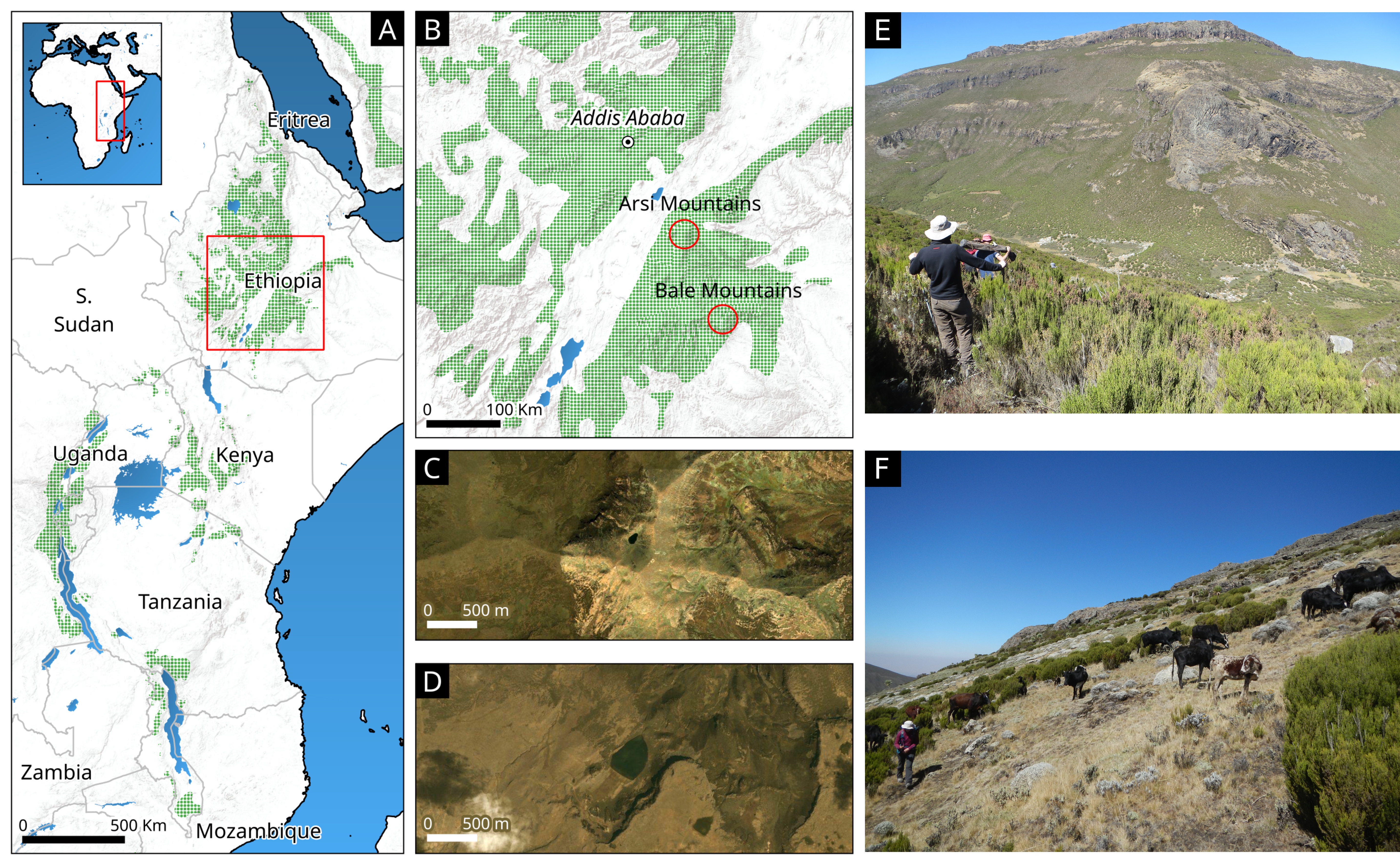 |
|
Figure 1: (A) The Eastern Afromontane archipelago; (B) Bale and Arsi Mountains National Parks (BMNP and AMNP respectively); (C) Haro Kori Lake (4000 m asl); (D) Garba Guracha Lake (3950 m asl); (E) heathland in Bale and (F) in Arsi areas. |
The Ericaceous belt is one of the most fragile Afromontane communities, dominated by Erica arborea and E. trimera stands (Bussmann 2006). It is especially and critically endangered by rising temperatures and unpredictable rains, rapid population growth, and agricultural expansion (Cincotta et al. 2000). Erica heathland is highly flammable with relatively low fire-return intervals (5–6 years), but when stands remain unburnt long enough to develop into forest (> 30 years), flammability decreases (Johansson et al. 2018). A fire-return interval between 6 and 30 years creates different degrees of heathland openness, from a dense community (Fig. 1e) to a more open one (Fig. 1f).
Despite recent research on the fire tolerance of the EB, the long-term burning tipping-points controlling Erica heathland sustainability are still largely unexplored. Conservation efforts in the EB have traditionally aimed to limit burning practices in protected areas, despite evidence that fire has been used as an agropastoral tool on the African continent for tens of thousands of years and current research suggesting that elimination of burning may result in high-severity fires (Johansson et al. 2018). The Ericaceous belt is one of the ecosystems where fire has long been used by people (Johansson and Granström 2014), and local knowledge and paleoecology therefore need to be considered in conservation planning.
Here we show how information on long-term ecosystem dynamics from the Ethiopian Ericaceous belt in the Bale Mountains National Park (BMNP; Fig. 1b) can be combined with interviews to pastoral communities of the Arsi Mountains National Park (AMNP; Fig. 1b). Both protected areas present similar vegetation and human activities, but AMNP receives less tourism, and traditional cattle and farming management is more widespread. Combining both perspectives will ideally produce an integrated scenario on past vegetation change, as well as a better understanding of local attitudes about the environment in the Ericaceous belt.
Combining past and present burning dynamics
The charcoal, pollen, and stable oxygen isotopic records from Lake Garba Guracha (3950 m asl; Fig. 1d), at the upper limit of the EB in the BMNP, provide information about Holocene fire, vegetation, and moisture availability (precipitation-to-evaporation ratio, P/E; see Bittner et al. 2020 for details on P/E ratio deduced from δ18O; Gil-Romera et al. 2021, 2019; Fig. 2). The data show three periods of Erica expansion and high fire activity (Fig. 2I, II, and III). Whether the ignition was human or natural, it is noteworthy that the periods of high fire activity occurred when moisture availability was either low or decreasing (Fig. 2c). This trend might be connected with reducing rainfall amounts, but also with increasing temperatures, as evaporation could have increased.
 |
|
Figure 2: Paleoecological data from Lake Garba Guracha record (3950 m asl, Ethiopia). (A) Fire record through charcoal accumulation rate; (B) Erica abundance inferred from pollen accumulation rates; (C) Precipitation/evaporation ratio based on δ18O(fucose) isotopes; (D) Pollen abundances of the major vegetation zones in BMNP. Charcoal and pollen discussion can be found in Gil-Romera et al. (2019; 2021); more details on δ18O(fucose) are given in Bittner et al. (2020). Grey areas I, II, and III reflect the most fire-active periods. |
The first period occurred at 11-10 kyr BP (Fig. 2I), when a sparsely vegetated landscape dominated by Afroalpine taxa was progressively replaced by Erica-dominated heathland (Fig. 2b and d). The coeval increase in fire activity and Erica expansion at ca. 10.5 cal kyr BP (Fig. 2I) occurred during an overall dry interval. It seems likely that biomass accumulation occurred during the rainy season and supported high fire activity during the dry season. In the second fire-active period, between 8.2 and 5.5 kyr BP (Fig. 2II), the climate was more humid than in the first period, but fire activity and Erica biomass also show a degree of co-variability during a progressive dry trend (Fig. 2a–c). In both periods, burning and biomass accumulation established a lead–lag relationship, where Erica was favored by fire at certain fire-return intervals, and Erica biomass fueled subsequent fires (see Gil-Romera et al. 2019 for numerical analyses). The third fire-active period occurred from 2.5 kyr BP to the present (Fig. 2III), under increasingly drier conditions as inferred by the P/E ratio (Fig. 2c). Fire activity was likely less intense than in previous periods, and, although Erica was abundant at 2.5 kyr BP (Fig. 2b and d), it decreased as the dry forest of the Afromontane biome extended upslope over the last 2500 years (Fig. 2d). The paleoecological record indicates more biomass burning during the early and mid-Holocene periods, while the EB proved to be resilient under fire frequencies between 4 and 30 years (Gil-Romera et al. 2019).
In light of the long-term environmental context, a meaningful conservation strategy would require understanding recent burning patterns in protected areas, where fire is currently banned. In February 2020, we explored the AMNP (Fig. 1b), which, unlike the BMNP (Fig. 1e), does not have dense heathland areas but rather open short Erica shrublands (Fig. 1f). To understand recent fire-vegetation relationships in this region, we interviewed six people from local agropastoral communities. Interviewees were between 30 and 40 years old and aware of landscape changes over the last two to three decades. They currently graze goats and cows and have a good knowledge of the recent burning practices in the area. Interviewees agreed that the last time the area experienced regular, large fires, aimed to produce new grass, was 10–15 years ago. Since the designation of the AMNP in 2011, burning has been banned. Two of the interviewees stated that:
"We got educated and therefore most of us do not burn any longer. However, sometimes people burn to keep hyenas away or simply as a tradition, and they send the cattle and the goats to eat the new grass and also the Erica saplings."
Interviewees explained that their parents' generation knew a very dense, impenetrable Erica landscape with remnants of Afromontane forests up to ca. 3000 m asl in AMNP. Interviewees were also aware that Erica plants, as well as grass cover, can return to a relatively dense shrubland within 2 to 4 years after a fire, in agreement with scientific understanding (Johansson et al. 2018). Despite the fact that burning was more frequent 20 to 30 years ago, fire was managed with return intervals of 4–5 years, which enabled the Erica heathland to become more dense.
On future integrative research
The evidence from paleoecology and local community knowledge suggests that past burning patterns in the Ethiopian highlands occurred under fire-conducive climates and seasonal biomass accumulations. We also inferred that intermediate fire return intervals, between 4 to 30 years, may have sustained a continuous Erica cover. The results suggest that a total fire ban will lead to important changes in EB structure and high-severity fires, given current increasing temperatures and population. Many questions remain about the extent to which local knowledge and recollections of past burning practices match the findings from high-resolution pollen and charcoal records in the area or other fire-information sources, such as remote sensing data. We plan to continue our paleoecological research in the Arsi Mountains by examining other lake-sediment records (e.g. Haro Kori Lake, Fig. 1c) as well as starting new calibration studies including the local knowledge and communities perspectives.
Acknowledgements
This contribution is part of the DFG project FOR 2358 "The Mountain Exile Hypothesis". The Department of Plant Biology and Biodiversity Management (Addis Ababa University), the Frankfurt Zoological Society and the Ethiopian Wolf Project Programme are acknowledged for all their support during our research. We thank the Ethiopian Wildlife Conservation Authority for providing us a research permit to work in Bale and Arsi Mountains National Park. We thank Katinka Thielsen, Terefe Endale, Abdela, Geremew Mebratu, Wege Abebe, and Awol Assefa for their support. The authors would like to dedicate this manuscript to all the Ethiopian people, currently struggling with civil unrest and armed conflict. Access to the full audio file with the interview is available upon request; please contact Graciela Gil-Romera.
affiliations
1Plant Ecology and Geobotany, Faculty of Biology, Philipps University of Marburg, Germany
2Pyrenean Institute of Ecology (IPE-CSIC), Zaragoza, Spain
3Department of Plant Biology and Biodiversity Management, College of Natural and Computational Sciences, Addis Ababa University, Ethiopia
4Institut für Geographie, Technische Universität Dresden, Germany
5Department of Soil Biogeochemistry, Martin-Luther-Universität Halle-Wittenberg, Halle an der Saale, Germany
6Department of Geography and Earth Sciences, Aberystwyth University, UK
7Trinity College, University of Dublin, Ireland
8Department of Geography, Philipps University of Marburg, Germany
contact
Graciela Gil-Romera: graciela.gilipe.csic.es
references
Bittner L et al. (2020) J Paleolimnol 64: 293-314
Burgess ND et al. (2007) Biol Conserv 134: 209-231
Bussmann RW (2006) Lyonia 11: 41-66
Cincotta RP et al. (2000) Nature 404: 990-992
Fischer J et al. (2021) Trends Ecol Evol 36: 20-28
Gil-Romera G et al. (2019) Biol Lett 15: 20190357
Johansson MU et al. (2018) Glob Chang Biol 24: 2952-2964
Johansson MU, Granström A (2014) J Appl Ecol 51: 1396-1405
Solomon N et al. (2019) Int J Environ Res Public Health 16: 4653
Valentí Rull![]()
Paleoecological records are useful in that they inform ecological restoration efforts by not only providing the most suitable pre-anthropic baselines, but also identifying unrealistic and unfeasible restoration targets due to climatic, cultural, and economic constraints.
Paleoecology can inform ecological restoration efforts, as it may help set the expected/desired pre-anthropic ecosystem targets and baselines (Willard and Cronin 2007; Willis et al. 2010). However, past reconstructions have also identified unexpected changes in community composition, with no modern analogs, in response to environmental shifts (Williams and Jackson 2007). It has been recommended that conservation and restoration efforts focus on viable strategies and consider the possibility that novel and unexpected ecosystems will emerge in the near future as a response to ongoing global change (Jackson and Hobbs 2009; Hobbs et al. 2014). Another source of uncertainty in the definition of restoration targets is the feasibility of rebuilding pre-anthropic conditions, especially in cases where ecosystems have already crossed a tipping point leading to irreversible regime changes. Paleoecology is also able to identify unrealistic restoration targets, which may help optimize conservation efforts by helping to shape more realistic targets for restoration. This paper shows some of these situations using case studies selected according to the experience of the author, but similar situations exist elsewhere. The main past and present features of the selected areas are described (also see Fig. 1). The main paleoecological trends in each area are shown in Figure 2.
 |
|
Figure 1: Location of case studies and examples of their current landscapes. (1) Typical landscape of the southern Gran Sabana (Venezuela) with palm stands growing on flooded savannas. (2) Landscape around Lake Montcortès (Iberian Pyrenees, Spain) with intensive cultivation and some montane forest patches. (3) Badlands of the Maunga Terevaka volcano (Easter Island, Chile) partially covered by grasslands. (4) Volcanic crater on São Miguel Island (Azores, Portugal) with extensive croplands and planted forests of exotic species. Images from Google Earth. |
1. Gran Sabana (Venezuela)
Type locality: Several lakes and bogs from the southwestern sector of the Gran Sabana region (Rull et al. 2013).
Pre-anthropic vegetation: Dense and diverse rainforests (Catostemma and Dimorphandra) and shrublands (Bonyunia), possibly with scattered savanna patches.
Present-day vegetation: Treeless savannas with gallery forests along rivers and palm stands of Mauritia flexuosa (morichales) on flooded terrains.
Current anthropic pressures: Extensive burning, surface mining, and international tourism.
Main paleoecological trends: Pre-anthropic woodlands occurred during the Younger Dryas (YD) and the Early Holocene (EH), when the climate was significantly colder and drier than that of today (13 to 10 cal kyr BP). Further burning, possibly by nomadic hunter gatherers, transformed the region into extensive treeless savannas with gallery forests along rivers. This persisted until ∼2 cal kyr BP, when the indigenous Pemon people settled the region and favored the establishment of Mauritia palm stands using selective burning.
Main restoration challenges: Climatic and cultural. Past YD and EH climates suitable for the occurrence of pre-anthropic vegetation are impossible to reproduce in the present conditions. In addition, rebuilding pre-anthropic landscapes would imply the removal of savannas and Mauritia palm stands, as well as the eradication of fire practices, which constitute key resources and traditions for the Pemon people.
2. Pyrenees (Spain)
Type locality: Lake Montcortès (Rull et al. 2021).
Pre-anthropic vegetation: Lower montane forests (Pinus and Quercus) and gallery forests (Alnus and Corylus) surrounding rivers and lakes.
Present-day vegetation: Croplands, pastures, badlands, and remains of low-montane forest.
Current anthropic pressures: Intensive and extensive agriculture, forestry, and regional tourism.
Main paleoecological trends: Pre-anthropic montane and gallery forests were affected by anthropogenic fires at ∼300 BCE (Iron Age) but were resilient until a second deforestation event occurred at ∼300 CE (Roman Period), when croplands significantly expanded. Fires stopped at the beginning of the Middle Ages (∼500 CE), but deforestation events (selective felling) continued until the Modern Age (∼1800 CE). During the last century, massive depopulation of montane areas due to population emigration to industrialized cities led to the expansion of montane forests (Trapote et al. 2018).
Main restoration challenges: Cultural and economic. The full large-scale recovery of pre-anthropic forests would require the abandonment of private agricultural and forestry practices at regional scales. This would necessitate a radical change in the local culture and/or in the land property regime, a situation that would be highly unpopular and likely unviable under the present socioeconomic conditions.
3. Easter Island (Chile)
Type locality: Two lakes (Kao and Raraku) and a bog (Aroi) (Rull 2020).
Pre-anthropic vegetation: Dense forests dominated by an extinct palm that covered ∼80% of the island.
Present-day vegetation: Grasslands, badlands, and scattered plantations of exotic trees (Eucalyptus).
Current anthropic pressures: Substantial international tourism.
Main paleoecological trends: The original palm woodlands, as old as ∼40 cal kyr BP, began to be removed by Polynesian colonizers around 1200 CE using fire. This deforestation was a spatiotemporally heterogeneous process across the island ending by 1600 CE, when the entire island was transformed into grasslands and badlands. During forest clearing, the islanders (Rapanui) developed gardening cultivation techniques that facilitated their subsistence until European contact (1722 CE), which signified the beginning of the demise of the ancient Rapanui culture. Landscape degradation was greatest in the 19th century, when the island was transformed into a sheep ranch.
Main restoration challenges: Cultural and evolutionary. The small island (>150 km2) has approximately 20,000 exposed sites and manifestations of the ancient Rapanui culture, still preserved in their original places, which were built up on a mostly deforested island. Rebuilding the original palm woodlands is not realistic under these conditions. In addition, the palm species that grew on the island are already extinct; therefore, their identity and ecological requirements are unknown.
 |
|
Figure 2: Vegetation changes in the areas considered in this work at three different temporal scales: The Holocene (1: Gran Sabana), the last 3000 years (2: Iberian Pyrenees), and the last millennium (3: Easter Island; 4: Azores Islands). Summarized from Rull (2020) and Rull et al. (2013, 2017, 2021). DF: deforestation using fire; SD: selective deforestation (mechanical); TP: tipping points; FE: forest expansion. |
4. Azores (Portugal)
Type locality: Lake Azul, São Miguel Island (Rull et al. 2017).
Pre-anthropic vegetation: Dense laurisilvas dominated by Morella faya and Juniperus brevifolia.
Present-day vegetation: Croplands, pastures, and extensive forest of exotic species, mainly Cryptomeria japonica (Japan) and Pinus pinaster (Mediterranean).
Present anthropic pressures: Intensive and extensive agriculture, forestry, and incipient tourism.
Main paleoecological trends: Pre-anthropic laurisilvas were abruptly removed using fire by the first European colonizers around 1400 CE, and the landscape was transformed into a mosaic of shrublands and grasslands. This persisted until ∼1800 CE, when extensive reforestation with exotic tree species began to shape present-day landscapes.
Main restoration challenges: Cultural and economic. As in the case of the Iberian Pyrenees, the eventual large-scale restoration of the original forests would require socioeconomic changes that would be difficult, or impossible, to implement under present conditions.
Restoration alternatives
The restoration impediments highlighted in the case studies above relate to large-scale or island-wide rebuilding of pre-anthropic ecosystems and landscapes, but other smaller-scale options are possible using the available paleoecological information. The possibility of restoring stands or patches representative of past plant communities outside (quasi in situ) or inside (inter situ) their natural distribution areas, either past or present, has been proposed (Burney and Burney 2007; Volis and Belcher 2010). Restoring past communities in protected areas such as national or regional parks, may also be feasible if current environmental conditions permit. Where landscapes are used for food production and other cultural purposes, a combination of these approaches would be the restoration of a series of communities that reproduce the different natural vegetation and landscape stages represented in paleoecological records to provide a historical account of the shaping of present-day landscapes.
Because paleo-inferred restoration targets can include communities that existed under warmer and/or drier climates or under different disturbance regimes, they may contribute to mitigate ecological global-change impacts. Specifically, these landscape mosaics may help to maintain biodiversity and, thus, important ecosystem properties and services. Ultimately, when large-scale restoration to pre-anthropic conditions is impossible, the paleodata can be used in framing realistic restoration targets at small to medium scales in multi-functional landscape mosaics. In cases such as Gran Sabana and Easter Island, where indigenous cultures are still present, the contribution of their traditional knowledge would be very useful for providing a holistic socioecological perspective that contributes to the conservation of cultural landscapes (Uprety et al. 2012; Wehi and Lord 2017).
Acknowledgements
The author is grateful to the editors of this Past Global Changes Magazine issue for the invitation to contribute and for their suggestions on the original manuscript. Basic research leading to the evidence discussed in this paper has been developed over the past 40 years and has been funded by a multitude of institutions and research programs from a diversity of countries; see the original data papers in the reference list for more detailed information.
affiliation
Botanic Institute of Barcelona (IBB-CSIC), Spain
contact
Valentí Rull: vrullcsic.es
references
Burney DA, Burney LP (2007) Front Ecol Environ 5: 483-490
Hobbs RJ et al. (2014) Front Ecol Environ 12: 557-564
Jackson ST, Hobbs RJ (2009) Science 325: 567-569
Rull V et al. (2013) Perspect Plant Ecol Evol Syst 15: 338-359
Rull V et al. (2017) Quat Sci Rev 159: 155-168
Rull V (2020) Biol Rev 95: 121-141
Rull V et al. (2021) Quat Sci Rev 268: 107128
Trapote MC et al. (2018) Rev Palaeobot Palynol 259: 207-222
Uprety Y et al. (2012) Ecoscience 19: 225-237
Volis S, Blecher M (2010) Biodiv Conserv 19: 2441-2454
Wehi PM, Lord JM (2017) Conserv Biol 31: 1109-1118
Willard DA, Cronin TM (2007) Front Ecol Environ 5: 491-498
Williams JW, Jackson ST (2007) Front Ecol Environ 5: 475-482