PAGES Magazine articles
Kerstin Schepanski1, U. Merkel2 and I. Tegen1
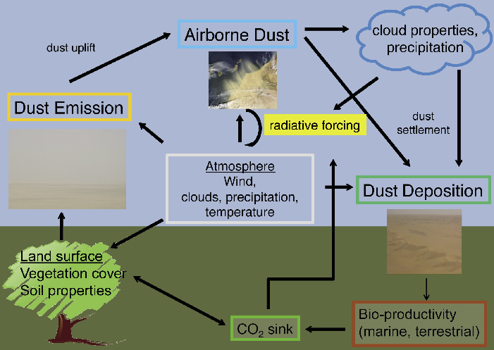
Dust contributes substantially to the aerosol load of the atmosphere, but lifting dust high above the ground requires specific meteorological conditions. Once mobilized, dust interacts with components of the Earth system in multifaceted ways, which causes modifications to the energy budget and ecosystems.
Bare land surfaces are the main sources for mineral dust. The most active and strongest dust sources are predominantly situated in semi-arid and arid regions at sub-tropical latitudes where subsiding air masses stabilize the atmosphere and dry climates prevail. In terms of dust emission flux and frequency of emission events, the Sahara Desert is considered the world's largest dust source, although the spatio-temporal variability and characteristics of its dust production are yet not fully understood.
 |
|
Figure 1: The atmospheric dust cycle and related feedback mechanisms. |
Dust uplift and entrainment into the atmosphere are determined by surface wind speeds and local land surface characteristics such as soil texture, soil moisture, and vegetation (Fig. 1). Dust emission is often described as a threshold problem, where particles are only entrained when wind speeds rise above a certain threshold transferring momentum from the atmosphere to the dust particles. The wind speed required for entrainment depends on soil characteristics (e.g. Marticorena and Bergametti 1995) such as particle shape, size and density, and inter-particle binding energy.
In addition to the atmospheric control on dust emission, land surface characteristics also play a role by determining the dust source's erodibility. Relative to atmospheric conditions, the land surface characteristics of dust sources remain fairly constant. Thus, the predominance of specific land surface conditions, such as smooth surfaces and the presence of fine and loose soil particles, is an important aspect in determining its erodibility. In particular, alluvial sediments are prone to wind erosion and play a significant role in many dust sources today and in the past (Reheis and Kihl 1995). As fresh layers of fluvial sediment deposits tend to occur in response to strong precipitation events such as flash floods, dust emission from this source type are characterized by more pronounced interannual variability.
Meteorological settings for dust emission
The processes contributing to dust source activation vary between seasons due to seasonal changes in atmospheric circulation patterns. Besides land surface characteristics, understanding the meteorological aspects of atmospheric conditions which provide sufficient wind (momentum) for dust uplift is crucial when discussing the dust cycle today, but also during ancient times and for future scenarios.
 |
|
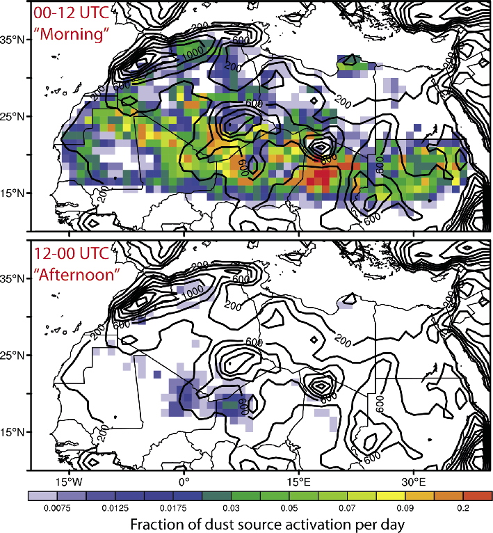
Figure 2: Diurnal variability of dust source activations over North Africa inferred from MSG-SEVIRI IR dust imagery for 2006-2010 following Schepanski et al. (2009). Figures shows the occurrence frequency of dust source activations in the first (top panel) and second (bottom panel) half of the day. Orography is given by contour lines. |
Recent studies analyzing satellite data and model simulations have identified different meteorological settings that play a key role in creating suitable atmospheric conditions for dust uplift (Schepanski et al. 2009). Satellite observations at 15-minute resolution revealed a strong diurnal cycle in the onset of dust emission and, integrated over months, synoptic climate patterns that result in dust uplift (Fig. 2). In terms of frequency and associated dust emission fluxes, the following meteorological processes are suggested: (1) downward mixing of the nocturnal low-level jet (LLJ), (2) cold pools induced by moist convection, and (3) baroclinicity and cyclogenesis.
A sudden and strong increase in surface wind speed occurs in the vicinity of a decaying nocturnal LLJ. LLJs are characterized by a low-level (~200-700 m above ground) wind speed maximum that forms due to the frictional decoupling of upper air layers from the surface air layers at night. These preconditions are frequently fulfilled during calm nights. Nocturnal LLJs usually begin to form before midnight and accelerate during the second half of the night. After sunrise, convective turbulence increases due to solar heating and erodes the nocturnal temperature inversion. Consequently, the LLJ layer is frictionally coupled to the surface layer and momentum from the LLJ is mixed downward leading to wind gusts and increased surface wind speeds, ultimately uplifting dust particles after sunrise when the resulting winds are strong enough. Nocturnal LLJs are a frequent phenomenon over North Africa and can explain a major fraction of observed dust source activations in space and time.
Cold pools, also described as downdrafts or gravity (density) currents, are initiated by deep convection. Evaporative cooling creates pools of cold air that subsides due to its higher density compared with the surrounding air. At the ground, the downward motion is transformed into a horizontal motion and the air mass spreads out horizontally forming a gust front. High surface wind speeds following the front can uplift dust and build an arcus-like dust front, a so-called Haboob. Although high dust emission fluxes are achieved during the passage of such a gust front, such dust emission events are less frequent than that from LLJs due to the rare occurrence of cold pools.
Strong surface wind fields also form in association with baroclinic disturbances and cyclonic systems, predominantly during boreal spring. Prominent examples are the cold outbreaks of Arctic air masses over China that result in dust fronts originating from the Gobi Desert, and Mediterranean cyclones which form dust fronts over Mediterranean North Africa and the Middle East.
Climate impacts of dust
The relevance of mineral dust for the modern climate system has been widely studied, most often from an atmospheric perspective through its impact on the radiative balance and on clouds. Dust impacts the radiation balance of the Earth by scattering and absorbing incoming solar radiation, and by absorbing and emitting terrestrial radiation. Net radiative forcing by dust depends on the optical properties of the particles, which in turn depend on their size distribution and mineral composition. The magnitudes and even the sign of the net radiative forcing at the top of the atmosphere by dust from both natural desert sources and anthropogenic (agricultural) land surfaces are highly uncertain. The uncertainty of estimates of global annual average forcing is in the order of 1-2 Wm-2 at the Earth surface (Carslaw et al. 2010).
Dust also provides nuclei for ice particle formation in the atmosphere and thus impacts the microphysical properties and the lifetimes of mixed-phase and ice clouds, and the kind and frequency of precipitation.
Dust now receives increasing attention from an Earth system perspective (Shao et al. 2011) since mineral dust interacts with different components of the Earth system (Fig. 1). For instance, the deposition of mineral dust on glaciers has the potential to lower their surface albedo, enhance their melt rates, and speed up their retreat (Oerlemans et al. 2009). This process and positive feedback mechanism may also have played an important role during Pleistocene deglaciations (Ganopolski et al. 2010).
The marine realm is also affected by mineral dust deposition. Downstream of major west African dust sources, tropospheric mineral dust cools the Atlantic ocean surface and mixed layer by 0.5-2°C in response to an increase in the aerosol optical depth (Evan et al. 2009; Martínez Avellaneda et al. 2010). Furthermore, Atlantic hurricane formation, could be reduced in response to two effects: (1) The dust's cooling effect on the surface ocean reduces the energy for strong atmospheric convection and (2) increased wind shear due to heating of air layers containing dust might impede the development of cyclonic cells. However, an unambiguous causal relationship has not yet been proven with sufficiently good data.
Through its impact on ocean surface temperatures and its modification of land-sea contrasts, dust may also feed back on the hydrological cycle, and thus on vegetation dynamics. In turn, associated changes in land surface conditions modify the dust mobilization potential of source areas. Superimposed on the natural dust variations, current and future anthropogenic land is altering the geographical distribution of preferential dust mobilization, although quantitative estimates of projected human-induced dust changes are highly uncertain (Mahowald et al. 2009).
Dust also impacts biogeochemical cycles. Over land, desert dust influences soil conditions in various ecosystems through phosphorous deposition. In the ocean, dust has been found to enhance marine productivity by iron fertilization (Jickells et al. 2005; Martínez-García and Winckler, this issue) and has been argued to increase particle settling rates through ballasting, i.e. the adhesion of organic matter to sinking mineral particles. This affects the ocean carbon cycle by enhancing organic carbon export from the surface to the deep ocean (Iversen et al. 2010; Ternon et al. 2010).
Perspectives
Geological records from ice cores, ocean sediments and loess deposits provide information about dust deposition in past climates. However, from a paleo-perspective, dust-relevant processes operate on extremely short timescales and relatively small spatial scales. Nevertheless, these processes are embedded in the large-scale background climatic state and low-frequent variations of the climate system, in addition to playing an important role through various feedbacks, e.g. the dust-snow-albedo effect, or the link to the ocean biological pump. Therefore, the geologic dust research should be flanked by modeling efforts which realistically implement the processes controlling dust emission, transport and deposition into global Earth system models to provide the required spatio-temporal context for the interpretation of the proxy evidence.
affiliations
1Leibniz Institute for Tropospheric Research, Leipzig, Germany
2MARUM, Bremen, Germany
contact
Kerstin Schepanski: schepanski tropos.de
references
Full reference list under: http://pastglobalchanges.org/products/magazine/ref2014_2.pdf
Evan AT et al. (2009) Science 324: 778-781
Ganopolski A et al. (2010) Clim Past 6: 229-244
Mahowald NM et al. (2009) Ann Rev Mar Sci 1: 245-278
Schepanski K et al. (2009) J Geophys Res 114, doi:10.1029/2008JD010325
Luca Lelli, W. von Hoyningen-Huene, M. Vountas, M. Jäger and J.P. Burrows
Satellite retrievals of aerosol optical thickness over the Atlantic Ocean have been used to estimate the rates of dust deposition. The results reveal higher dust deposition in summer than in winter and give insights into the location of desertic dust source areas.
Desert dust (or dust aerosol) outflows off the West African coast impact offshore biogeochemical processes and can be regarded as natural hazards to human activities and ecosystems. For example, dust storms affect aviation operations reducing flight visibility, causing engine mechanical damages and flight path reassessments. On the other hand, dust input adds nutrients to the surface of the seas which stimulate phytoplankton production, and higher particle flux can increase export fluxes of biomass from the surface waters to the sea floor and hence increase accumulation rates in the underlying sediments.
Dust is collected on land only at few observation sites, like at Cape Blanc (Mauritania) or Barbados (Fischer and Karakas 2009; Prospero 1999). Conversely, remote satellite monitoring of dust transport covers the entire Atlantic Ocean and is therefore an invaluable complement to in-situ measurements.
Standard remote sensing techniques of dust are based on the physical principle of extraterrestial sunlight travelling through the Earth’s atmosphere and being attenuated by suspended dust particles. Nadir-looking spectral satellite radiometers (e.g. SeaWiFS, MERIS, MISR, MODIS) measure the amount of sunlight reflected back to space and allow us to determine the degree of sunlight attenuation. The latter is described by Aerosol Optical Thickness (AOT), which is defined as the extinction coefficient of light integrated over a vertical column through the atmosphere. AOT can be calculated from data of reflected light with algorithms like the Bremen AErosol Retrieval (BAER; von Hoyningen-Huene et al. 2003, 2011) and monitored both in space and time. However, such algorithms are challenged not only by missing a-priori information on the specific optical properties of dust (Dinter et al. 2006), but also by local reflectivity of the ground. Radiant surfaces (such as the bright Sahara) may reduce the contrast between suspended dust and the ground beneath, hence degrading the overall algorithmic performance and accuracy.
 |
|
Figure 1: Monthly averages of Aerosol Optical Thickness (AOT; dimensionless) retrieved from MISR satellite data for the determination of dust sedimentation rate. Maps of AOT for January and July 2001 on a global scale (A) and zoomed in to the example region around Cape Blanc (B), where sediment traps are deployed across West Africa and the Atlantic Ocean. The time series in (C) portrays the AOT signal extracted for the adjacent boxes M1 and M2. The oscillations of both curves indicate that dust activity is more frequent in summer than in winter. Dust deposition is reflected by the difference between the red and black curves during the respective months. |
Figure 1 shows seasonal variations in satellite-derived AOT in dust-laden regions worldwide. Off West Africa, for example, AOT is about three times as high in summer than in winter.
From optical thickness to dust deposition
Comparisons of satellite-derived AOT and data from sediment traps over West Africa and the Northern Atlantic do not show a direct relationship between atmospheric dust loading and dust accumulation. However, the spatio-temporal change of dust AOT can be used as an indicator for the fallout of aerosol along the transport path. The method described in the following, has been developed to determine dust deposition from satellite data.
The deposition rate of aerosol particles is reflected by the decrease of AOT along the transport path rather than AOT itself. Driven by this idea, a method has been developed to determine the relative change of AOT along an estimated transport path. This requires that the aerosol loading is determined from AOT for the region of interest, i.e. the AOT needs to be transferred quantitatively into aerosol mass load. The algorithm for this is based on assumptions on the dust grain size and dust particle density in the air.
Mass loss (or sedimentation rate) which can be directly compared to ground measurements can be derived from lateral dust transport in two ways: (i) using a transport model with a sedimentation module or (ii) estimating the mass loss from the change in the aerosol columnar mass along the trajectory. Here, the latter approach is followed.
The sedimentation rate is inferred from the mass difference along the main aerosol transport path. If one takes the temporally averaged AOT of two adjacent regional boxes (see boxes M1 and M2 in Fig. 1) along the main trajectory, a sedimentation rate can be estimated from the difference between the red and black AOT curves (Fig. 1C). Our new method allowed us to produce estimates of dust deposition from monthly averages of AOT on a regional grid.
Testing the method
 |
|
Figure 2: Time series of AOT changes between boxes M1 and M2 (see Fig.1), derived from satellite retrievals from SeaWiFS (black curve) and MISR (blue curve) instruments. The curves can be considered as approximations for the rate of dust deposition at the site of Cape Blanc. |
Preliminary qualitative comparisons have been made for Cape Blanc on the coast of Mauretania, using deposition data by Fischer and Karakas (2009). First, AOT values were calculated with the BAER algorithm using SeaWiFS data. Then, two grid boxes over the site and offshore Cape Blanc were selected. The two neighboring boxes are located between 20°N and 22°N (see M1 and M2, Fig. 1). We assume that both boxes are located along the main westward oriented dust transport path. Even though this assumption is only of limited validity and the time series of the difference between AOT in both boxes shows some negative values (Fig. 2), the analysis of the time series reveals a potentially promising correlation (r > 0.6) between the AOT derived from remote sensing and in-situ sedimentation data from Cape Blanc (unpublished, not shown). Figure 2 also shows that the method is sensitive to the satellite radiometers used. The pictured values of AOT changes, derived from SeaWiFS and MISR measurements, exhibit differences that can be attributed to distinct instrumental characteristics.
These preliminary results are a first step towards a systematic application of this method. However, the approach needs significant improvements in terms of the consideration of dust transport trajectories, the injection height of dust, its mixing with surrounding air and optical parameters used for determining the local dust type.
affiliations
Institute of Environmental Physics and Remote Sensing (IUP), University of Bremen, Germany
contact
Luca Lelli: lucaiup.physik.uni-bremen.de
references
Fischer G, Karakas G (2009) Biogeosciences 6: 85-102
Prospero JM (1999) J Geophys Res 13: 15917-15927
Von Hoyningen-Huene W et al. (2003) J Geophys Res 108
Von Hoyningen-Huene W et al. (2011) Atmos Meas Tech 4: 151-171
Yaping Shao
Knowledge about today’s climate-dust dynamics is the basis for the interpretation of dust deposition records. Regional climate models with built-in dust modules provide insights into dust transport out of the major source regions and facilitate direct comparison with sediment sequences.
Atmospheric dust loads have varied substantially over time (Maher et al. 2010), as revealed in dust records in ice cores (Lambert et al. 2008), deep-sea sediments (Winckler et al. 2008) and loess sequences (Ding et al. 2001). A key feature of Greenland and Antarctic ice cores is the pronounced dust load variations between glacials and interglacials, with more dust during glacials than during interglacials (Fischer et al. 2007). Deep-sea sediments also indicate high dust loads during glacial stadials; for example Moreno et al. (2002) found higher dust transport from the Sahara to the western Mediterranean during the cold stadial periods of the Dansgaard-Oeschger cycles.
Modern dust variability
 |
|
Figure 1: (A) Time series of global monthly-mean dust concentration, and the corresponding 95% confidence interval (in error bars), for the period 1974-2012, together with the yearly running mean and the linear trends. The trend for the full is shown by the dashed red line, for the period 1984-2012 by the solid red line. (B) Time series of the AMO index as monthly and yearly running mean, and showing the linear trend. |
Dust records reflect past climate changes in the form of varying deposition rates, particle size and dust mineralogy, but their interpretation is not straightforward. It is therefore important to understand the present-day climatic drivers of dust processes and their variability on different time scales. Using synoptic dust-weather and visibility data for the period 1974-2012, Shao et al. (2013) analyze recent dust trends and their link to climatic drivers. Figure 1a shows a series of the global monthly-mean dust concentration. For the period 1974-1983, the uncertainty in the dust concentration estimates is larger due to the smaller sample size (~20,000 month-1) relative to 1984-2012 (~300,000 month-1). The data analysis shows that dust concentration was in the order of 10-100 μgm-3 and decreased by about 0.2-0.5 μgm-3 per year over the past four decades. This trend is attributed primarily to decreasing dust production in North Africa and Northeast Asia.
Correlations have been examined between dust variability and key indices that affect climate variability in North Africa, including the Multivariate El Niño Southern Oscillation (ENSO) index (MEI), the North Atlantic Oscillation (NAO), and the Atlantic Multi-decadal Oscillation (AMO). The AMO is the main cause of tropical Atlantic sea surface temperature fluctuations and oscillates with a period of ~70 years (Goldenberg et al. 2001). A positive AMO phase corresponds to enhanced rainfall in the Sahel and above-normal hurricane activity over the Atlantic. Wang et al. (2012) used a dataset with records extending back to the 1950s and found multi-decadal co-variability between North Atlantic sea surface temperatures, African dust and Sahel rainfall (as well as Atlantic hurricanes). Low North Atlantic temperatures were accompanied by more African dust and less Sahel rain; high temperatures by less dust and more rain. The dust concentration time series for North Africa is significantly negatively correlated with the AMO index. This negative correlation has also been detected in several previous studies (Foltz and McPhaden 2008; Evan et al. 2012). No significant correlations were found between dust and MEI or NAO. This indicates that the present day global dust trend might be determined by the climate systems that govern variability in the Atlantic-North African region, i.e. mainly by the AMO. Regionally, the dominant drivers can however be different. Dust in Northeast Asia is more related to the Arctic Oscillation, while dust in Australia is primarily related to ENSO. Currently, there is not enough evidence to directly attribute the decreasing trend in dustiness over the last decades to global warming.
Dust modeling
Increased interest in dust has prompted rapid progress in dust modeling since the late 1980s. It began primarily with modeling dust transport, but has since grown to the point that comprehensive dust models have been developed and applied to all major dust regions around the world, in particular North Africa, Northeast Asia and Australia. Since the 1990s dust components were included in global climate models (e.g. Tanaka and Chiba 2006) by building dust modules into the model's atmospheric component. The central task of dust modeling in this context is to solve the dust budget equation for various particle size groups, including the computation of dust emission, transport and deposition.
 |
|
Figure 2: (A) Simulated dust load for the Australian dust event on 23 September 2009, using the WRF-CHEM/D model with a spatial resolution of 40 km. Australian dust is transported across the continent along two major routes: the southeast route along which dust is transported to the southern Pacific Ocean and the northwest route to the Indian Ocean. (B) MODIS satellite image from the morning of 23 September 2009. (C) As (B), but from 24 September 2009. The satellite images confirm the good performance of the model. |
Early dust models were not equipped with adequate dust emission and deposition schemes. In the late 1980s, dust emission schemes were developed based on wind erosion physics (e.g. Alfaro and Gomes 2001; Kok 2011) and more recently, measurements of size-resolved dust fluxes have become available for scheme validations (Ishizuka et al. 2014). Using these methods, dust simulations on continental scales have been quite successful. Figure 2 shows an example of the WRF-CHEM/D simulation of the Australian dust event of 23 September 2009, the strongest dust strom event on meteorological record, which swept over almost the entire Australian continent. Comparison with satellite observations shows that the simulation captured features of the dust event development and the dust distribution patterns well.
Present-day dust transport modeling provides information about dust dynamics as a basis for the interpretation of paleo-dust records. The particular example shown in Figure 2 suggests that Australian dust is transported across the continent along two major routes: the south-east route along which dust is transported to the southern Pacific Ocean and the north-west route to over the Indian Ocean.
Simulations of modern dust transport in North Africa revealed that Saharan dust is primarily transported towards the monsoon region in Western Africa by the northeasterly wind and then westward by the easterlies in the tropics (Klose et al., 2010). In winter, dust is transported mainly along a southerly route, while in summer a more westerly route dominates. The simulation of a typical dust event suggests that much of the dust transported to the tropical Atlantic originated from the northeastern part of North Africa (Libya, Egypt and Sudan). Dust emitted there was advected toward the Sahel dust zone and then transported westwards over the Atlantic. The Sahel dust zone exists in a climatic sense in terms of dust event frequency. It is located between 10 and 16°N, stretching several thousand kilometers over the Sahel from west to east, reaching the western boundary of the Ethiopian Highlands.
Finally, simulations in Northeast Asia revealed that the motion of the Mongolian cyclones and the cold air generally follow the East Asian trough. Dust from the Taklimakan and Gobi deserts is primarily transported toward the southeast and then the northeast. The Tarim Basin, in the Taklimakan desert, is no more than 1000 m a.s.l., but is surrounded by mountains of ca. 3000 m altitude. Dust is first lifted vertically by convection and basin-scale mountain-valley circulation to 8-10 km a.s.l. (see also Bory, this issue). Due to the strong westerlies in the upper atmosphere, the uplifted dust can travel more than once round the Earth (Uno et al. 2009).
Perspectives on paleo-dust modeling
Efforts are now being made to model dust in paleoclimate scenarios using Earth System Models (ESMs), such as those participating in the Paleoclimate Modeling Intercomparison Project Phase 3 (PMIP3; Otto-Bliesner et al. 2009). Within PMIP3, more than 20 GCMs/ESMs are run over 100 to 500 year periods centering on the Holocene, the Last Glacial Maximum and the Eemian Interglacial.
Regional climate models with built-in dust modules, such as the WRF-CHEM/D (Kang et al. 2011), were nested within the PMIP3 simulations to regionalize paleo-dust information and make comparison with sediment sequences easier. This should allow investigation of the dust patterns in North Africa during the Holocene and LGM. The outcomes of such model simulations are expected to strengthen the paleoclimatic interpretation contained in dust records. At present, this effort is confronted with the need for reconstruction of land-surface and regional climate and weather conditions. Our understanding of paleo land-surface conditions (e.g. soil type and vegetation cover), which ultimately determine the distribution and strength of paleo dust sources, is rather low. PMIP3 simulations generally have coarse spatial and temporal resolutions, which are insufficient for reliable paleo dust modeling. However, some progress has been made by use of techniques such as statistic-dynamic downscaling and ensemble simulations to reproduce paleo weather patterns for potential paleo dust regions.
affiliations
Institute for Geophysics and Meteorology, University of Cologne, Germany
contact
Yaping Shao: yshaouni-koeln.de
references
Full reference list under: http://pastglobalchanges.org/products/magazine/ref2014_2.pdf
Evan AT et al. (2012) J Climate 25: 5817-5829
Ishizuka M et al. (2014) Aeolian Res 12: 87-99
Kang J-Y et al. (2011) J Geophys Res 116
Joseph M. Prospero
Mineral dust in sediments and ice cores is often used as a proxy for changes in aridity and large-scale wind systems. Long-term dust measurements on Barbados and other Atlantic sites show a close but complex relationship between hydroclimate and dustiness.
Mineral dust plays a role in many aspects of climate through atmospheric processes by absorbing and scattering solar radiation and by impacting cloud microphysical processes (Shao et al. 2011). Also, dust deposited to the ocean yields nutrients that can modulate marine biogeochemical processes and the global carbon cycle and, hence, climate (Shao et al. 2011). The climate-dust relationship is complicated by the fact that dust generation and transport are themselves modulated by climate.
Dust records in sediments and ice cores show that transport has varied greatly over glacial-interglacial (Maher et al. 2010) and shorter timescales. In order to use dust as a proxy in paleoclimate studies, we need to understand the role that climate plays in modulating dust transport today. This information is also important to understanding how dust can itself affect climate. Here we present the results of long-term network studies in the North Atlantic that characterize the great variability in transport over the region. These studies yield insights into some of these processes that affect variability and give direction for further research on the link to climate.
The Barbados record
North Africa is the focus of much dust research because it is the world's largest persistently active source, accounting for about 70% of total dust emissions (Huneeus et al. 2011). Much of this dust is carried to the west over the Atlantic in large-scale plumes, some of which can be tracked by satellites all the way to the southern United States (Bozlaker et al. 2013), the Caribbean and South America (Chin et al. 2014; Yu et al. 2013).
Our understanding of long-term trends in dust transport to these regions rests largely on aerosol monitoring studies on Barbados that began in 1965 (Delany et al. 1967; Prospero and Lamb 2003) and which continue to this day at the University of Miami atmospheric chemistry field site located on the east coast of Barbados (13.17°N; 59.43°W; Prospero and Mayol-Bracero 2013).
 |
|
Figure 1: Barbados annual mean dust concentrations and Sahel June-October Precipitation Anomalies (SPA) from 1965-2011. To more easily compare dust concentrations with rainfall metrics, the SPA values are plotted as the arithmetic negative. SPA data are taken from www.jisao.washington.edu/data_sets/sahel/ with anomalies calculated from data over the period 1950 to 2011. |
Barbados dust concentrations show great variability on a broad range of time scales ranging from days, to seasons, to decades (Prospero and Lamb 2003). Of particular interest is the long-term variability seen in the annual mean concentrations over 1965-2011 (Fig. 1). Dust transport increased sharply in the early 1970s with the onset of severe long-term drought in West Africa and peaked in the mid-1980s coincident with the most intense phase of the drought.
This increase focused attention on the role of rainfall in the dust cycle particularly in the Sahel, a region that depends greatly on the seasonal progression of the West African monsoon to provide rainfall (Marticorena et al. 2010; Doherty et al. 2012). In the first half of the record, increased transport is clearly associated with markedly drier conditions in the Sahel as seen in the close relationship between rainfall variations (expressed as Sahel Precipitation Anomalies; SPA) and dust concentration (Fig. 1). SPA is based on precipitation departures from the mean over the period 1950-2011. This association fits our general expectation that drier climate results in dustier conditions.
However, beginning in the early 1990s, this relationship appears to weaken. Dust concentrations remain relatively high despite increased rainfall and evidence of "greening" in the Sahel (de Jong et al. 2011). Although there is considerable year-to-year variability in dust transport and rainfall there is no strong relationship between the two. Note, for example, that dust concentrations in 1987, 1997-1998, and 2010 were comparable to those at the peak of the drought; in contrast, the SPAs, although moderately positive (i.e. relatively dry) were generally closer to the long-term mean. It is notable that over the period 1989 to 2005 most SPA annual means fall within a narrow range and show no evidence of a trend. However, after 2007 rainfall was close to normal yet dust concentrations remain moderately high, especially in 2010.
Dust transport to South America
The annual mean values on Barbados (Fig. 1) are strongly weighted by the high dust concentrations that prevail during boreal summers. Although dust concentrations are low in winter and spring on Barbados, we know that there is intense dust activity in North Africa in the Sahel region, most prominently in the Bodele Depression in northern Chad (Ben-Ami et al. 2012). Bodele sediments, deposited during the Holocene in what was Lake Mega Chad, are now being mobilized in huge quantities (Washington et al. 2009). Almost daily in spring, satellites show immense plumes being carried westward across the Atlantic, many eventually reaching South America in the region of French Guiana, 8000 km from the source. Ten years of recent air-quality aerosol measurements from Cayenne, a coastal town in French Guiana (04.95°N; 52.31°W), show a strong annual cycle with a spring maximum (Prospero et al. 2014). The magnitude and persistence of dust transport has had a significant impact on the supply of minerals and nutrients to the soils and sediments to the Caribbean and South America (including the Amazon; Ben-Ami et al. 2012; Muhs et al. 2007) and to the tropical and subtropical Atlantic (Baker et al. 2013).
Dust transport to the North Atlantic
 |
|
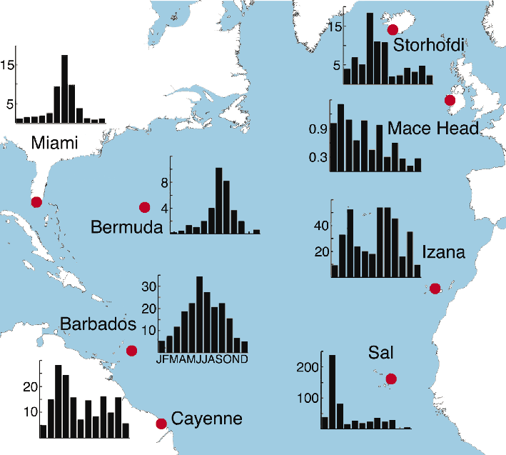
Figure 2: The annual cycles of monthly mean dust concentrations at University of Miami network sites in the North Atlantic. The means at each site are based on multi-year data but they are not necessarily measured concurrently. Note the difference in the ordinate scales in each inset figure. Figure adapted from Prospero et al. (2012). |
The Barbados and Cayenne measurements and those made at other sites in the Miami Atlantic network (Fig. 2) document the widespread impact of mineral dust over the North Atlantic. Dust concentrations at all sites except Mace Head (Ireland) and Storhofdi (Iceland) are dominated by African dust, most notably in the subtropical and tropical regions. Iceland dust is transported by winds from paraglacial deposits in southeast Iceland and deposited to the North Atlantic where it might serve as an important source of nutrient iron (Prospero et al. 2012).
The summer maximum observed at Barbados, Miami, and Bermuda contrasts greatly with the spring maximum at Cayenne, which reflects the combined effects of the seasonal shifts in African dust sources and in the transporting wind systems. The records closest to Africa at Izaña (Tenerife) and Sal Island (Cape Verde Islands) differ greatly in seasonality and in concentrations from those observed at the western sites (Fig. 2). This contrast shows that dust transport processes to the eastern Atlantic differ from those that carry dust to the western Atlantic (Stuut et al. 2005) and complicates attempts to relate the composition of sediments in the eastern Atlantic to the more westerly regions.
In order to more fully understand the various factors affecting dust mobilization we need a better understanding of the most active source areas (Prospero et al. 2002), the factors affecting source activity (Formenti et al. 2011; Ginoux et al. 2012) and the relationship between source soil properties and those of the emitted aerosol, such as particle size (Mahowald et al. in press) and composition (Scheuvens et al. 2013). This knowledge is important to interpreting dust-climate relationships and decoding the paleo-dust records from sediments and ice cores.
Understanding dust and climate
While rainfall is a critically important factor for dust emission, we know that other factors also play a role (Okin et al. 2011), most notably wind speed and gustiness (Ridley et al. 2014) and terrain features, especially vegetation cover (Bullard et al. 2011). In the future, land use and land disturbance will become increasingly important (Ginoux et al. 2012) as populations shift and grow. The complexity of these relationships presents a challenge to the modeling community (Huneeus et al. 2011).
Africa, as the world's largest present-day dust source, presents a special challenge when anticipating the changes in dust emissions in coming decades. It is notable that in the recent IPCC assessment, models forecast that large areas of North Africa will become drier (Seneviratne et al. 2012). However, the models could not agree on the future trends in large areas of North Africa that today are the most active dust sources, most notably those in the Sahara and the Sahel. Thus, it is important that we continue to monitor transport from Africa to the Atlantic in a systematic manner so as to track changes over this region and to test the ability of dust-climate models to characterize long-range transport to the oceans (Schulz et al. 2012).
acknowledgements
This research is supported in part by NSF Atmospheric Chemistry grant AGS-0962256.
affiliations
1Rosenstiel School of Marine and Atmospheric Science, University of Miami, USA
contact
Joseph M. Prospero: jprosperorsmas.miami.edu
references
Full reference list under: http://pastglobalchanges.org/products/magazine/ref2014_2.pdf
Ben-Ami Y et al. (2012) Atmos Chem Phys 12(5): 2253-2262
Huneeus N et al. (2011) Atmos Chem Phys 11(15): 7781-7816
Prospero JM, Lamb PJ (2003) Science 302: 1024-1027
Prospero JM, Mayol-Bracero OL (2013) Bull Am Meteorol Soc 94: 1329-1337
Prospero J M et al. (2014) Global Biogeochem Cycles 28: 757-773
Jan-Berend W. Stuut1,2 and Maarten A. Prins3
The physical properties of mineral-dust particles turn out to be more important than hitherto recognized; their composition, radiative properties, and fertilizing and ballasting potential fluctuate on various spatial and temporal scales. Especially the impact of large dust particles is often underestimated.
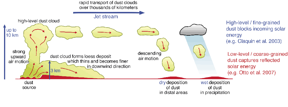
The role of aeolian dust for the radiation balance of the Earth is size-dependent. Dust has a direct cooling effect when small particles (< 2 µm) elevated into the high atmosphere block incoming sunlight (e.g. Claquin et al. 2003), but it can also act like a greenhouse gas when larger particles (> 10 µm) remaining in the lower atmosphere absorb and re-emit energy reflected from the Earth’s surface (e.g. Otto et al. 2007). Therefore, to account for the climatic effect of mineral dust it is critical to have a good understanding of the size distribution of suspended particles in space and time.
However, until now, the scientific community has not considered the fact that dust particles suspended in the atmosphere and transported over large distances (>1000’s km) can easily be of sizes >10µm. Specific set-up of air-monitoring programs, which are designed to measure air quality for human health studies and follow the guidelines of the World Health Organization (WHO), which do not consider particles larger than 10 µm. For this reason, these large dust particles are often simply not measured. As a consequence, they do not show up in the records and therefore seem non-existent.
Grain size sorting during transport
 |
|
Figure 1: Schematic diagram showing different dust-transport mechanisms in the high- and low-level atmosphere (redrawn from Pye and Zhou 1989). |
The particle-size distribution of mineral dust is not only a function of lateral but also vertical transport distance (e.g. Torres-Padrón et al. 2002). This observation had already been put into a conceptual model by Pye and Zhou (1989; Fig. 1). As wind is a very size-selective transport mechanism, the sediments it had carried typically a well-sorted particle-size distribution, which gradually gets finer from proximal to distal deposition sites. This fact has been used in numerous paleo-environmental studies to both determine source-to-sink changes in the particle size of aeolian dust (e.g. Sarnthein et al. 1981; Prins and Vriend 2007) and to quantify accumulation rates of aeolian dust (e.g. Prins and Weltje 1999; Moreno et al. 2005). Obviously, at proximal locations (where aeolian dust is deposited relatively close to its source), particles are coarser grained and mass accumulation rates are larger than at more distal locations (where aeolian dust is deposited relatively far from its source). This observation was first prominently described by Sarnthein et al. (1981; Fig. 2).
Evidence for large aeolian particles
 |
|
Figure 2: Map of the subtropical northeastern Atlantic, showing the decrease in both particle size and dust flux as measured in surface sediments by Sarnthein et al. (1981). |
Despite the availability of these conceptual models and many grain-size related studies, there are still many unresolved questions related to the physical properties of wind-blown particles, particularly their particle size and shape. Most of the mineral-dust particles that are suspended in air and collected further than 100 km away from their source are smaller than 20 µm (e.g. Middleton et al. 2001, and references therein). This particle-size constraint can be explained by the physical laws of entrainment and settling velocities (e.g. Gillette 1979). However, various aeolian-dust records from loess and marine sediments contain considerable amounts of coarse-silt and fine-sand grains, i.e. particles well above the theoretical 20 µm size limit.
Moreover, there are many examples of so-called “giant” sand-sized (> 63 µm) mineral particles collected more than 5,000 km away from their source. For example, quartz particles originating from the Asian deserts were collected on Hawaii (Betzer et al. 1988), Asian-dust particles were collected in free-drifting sediment traps in the north Pacific (Middleton et al. 2001), volcanic particles were found in Greenland ice (Ram and Gayley 1991), and Saharan-dust particles were observed in high-volume dust collectors over the distal Atlantic ocean (Stuut et al. 2005). New unpublished results from transatlantic Saharan dust-monitoring projects (e.g. SALTRACE and DUSTTRAFFIC) show how large (>20 µm) Saharan-dust particles are observed suspended in the atmosphere, as well as deposited in moored marine sediment traps at thousands of kilometers from the African coast.
These observations suggest that the assumptions regarding the transport capacity of individual dust outbreaks need to be revised (e.g. Menéndez et al. 2014). Such revisions would have consequences not only for the interpretation of the proxy records, but also for the quantification of the climate-forcing effect of wind-blown particles in the atmosphere (e.g. Boucher et al. 2013).
Marine production and export
The size and shape of aeolian particles and dust-transport processes may also have affected past atmospheric CO2 changes, due to the role that sinking dust particles may play in the biological carbon pump in the oceans. Martin and Fitzwater’s (1988) famous Fe hypothesis predicts that during glacial periods more micro-nutrients were transported to the ocean by mineral-dust, which boosted the growth of marine phytoplankton and zooplankton. The increased primary productivity and its downward export sequestered additional CO2 from the atmosphere (see also Martinez-Garcia and Winckler, this issue). A crucial step in this process is the export of organic matter from the surface ocean to the sea floor. Many Fe-fertilization experiments were carried out as a consequence of the postulated Fe hypothesis (e.g. de Baar et al. 2005). They demonstrated that it is indeed possible to boost marine life with artificially added dissolved micro-nutrients, but that most of the generated organic tissue containing the sequestered CO2 is being recycled in the surface ocean layer. Here, the dust particles may play a crucial role by providing mineral ballast for the aggregation and sinking of the organic tissue. If this ballasting process is fast enough, there is less time for the organic tissue to be recycled and the export of organic matter becomes more efficient. The speed of the downward transport from surface to the deep ocean is directly related to the size of the dust particles that act as anchors for organic matter.
Intuitively, one would think there is an upper limit to size and potential scavenging; a brick would be too large and sink too fast to have a significant scavenging effect. However, given that the largest dust particles observed near the African coast are smaller than 200 µm (e.g. Ratmeyer et al. 1999; Skonieczny et al. 2013; Stuut, unpublished data from a dust monitoring station in Iwik, Mauritania) and thus still have a relatively slow sinking speed, we assume that there are no dust particles too large to have a ballasting effect.
From the above, we infer that the largest ballasting and scavenging effect will take place at proximal deposition sites. Thus, even without adding nutrients to the ocean, mineral dust may increase the C-cycle by speeding up the export of organic material to the sea floor.
On the other hand, particle size and associated sinking speed also impacts the bio-availability of the dust-borne micro-nutrients; the faster the particles sink, the less time remains to mobilize the nutrients they carry. Therefore, at distal locations, where dust particles are small and the size-dependent specific surface area of the particles is high, the amount of nutrients per mass is much higher than at proximal sites. We speculate that there is an ideal source-to-sink distance where dust particles are large enough to have an optimal ballasting effect, but also small enough to have an optimal fertilizing effect.
Outlook
The aforementioned role of mineral-dust particles assumed all deposition to be the result of gravitational settling from the atmosphere. However, hardly anything is known about wet deposition of mineral dust. New observations (Prospero, pers. comm.) seem to indicate that fluxes of wet-deposited dust not only are larger than those of dry deposition but that these “wet” mineral-dust particles are also coarser grained. Transatlantic observation projects have been set up to shed light at source-to-sink variability at high temporal resolution. Next to the physical and chemical properties, also the temporal and spatial (micro-)biological effects on nutrient availability and scavenging need to be studied, as they may play a dominant role on the aforementioned physical processes.
affiliations
1NIOZ - Royal Netherlands Institute for Sea Research, Den Burg, the Netherlands
2MARUM - Center for Marine Environmental Sciences, Bremen University, Germany
3Earth Sciences, Vrije Universiteit Amsterdam, the Netherlands
contact
Jan-Berend Stuut: Jan-Berend.Stuutnioz.nl
references
Full reference list under: http://pastglobalchanges.org/products/magazine/ref2014_2.pdf
Betzer PR et al. (1988) Nature 336: 568
Claquin T et al. (2003) Clim Dyn 20: 193-202
Martin JH, Fitzwater SE (1988) Nature 331: 341-343
Stuut J-BW et al. (2005) J Geophys Res 110, doi:10.1029/2004JD005161
Aloys J-M Bory
Mineralogical, elemental and isotopic measurements point to Eastern Asia as the main source of dust reaching Greenland, both in the present and during the last glacial period. Data suggest that the bulk of the dust derives from the Taklamakan Desert of western China.
Determining the provenance of ice core dust is key to our understanding of the prominent variability in the dust concentration observed in the Greenland and Antarctic ice core records (see also Vallelonga et al. and Gili-Gaiero et al., this issue). Greenland dust provenance was a matter of speculation until the mid 90s. Some studies based on modern aerosol elemental composition suggested the Saharan region as a possible source (Mosher et al. 1993) while back trajectory calculations favored East Asian or North American provenances (Kahl et al. 1997).
The Eastern Asian signature of Greenland ice core dust
A major breakthrough came with the analysis of dust extracted from the Greenland Ice Sheet Project (GISP2) ice core record obtained at Summit in central Greenland. Based mainly on the clay mineralogy of the dust, Biscaye et al. (1997) were able to rule out the Sahara and North American deserts as significant contributors to the dust deposited in Greenland during the Last Glacial Maximum. They showed that instead it closely resembled the fine material deposited in the Chinese Loess Plateau region and must therefore have derived from adjacent deserts. An Eastern Asian provenance was also supported by radiogenic isotope ratios (Sr, Nd and Pb), which were consistent with a Chinese Loess Plateau signature, taking into account the fact that ice core samples unavoidably contain variable amounts of volcanogenic particles mixed with the dust. These findings were confirmed by evidence from rare earth element patterns and extended through several levels of the Greenland Ice Core Project (GRIP) record spanning over 30 ka across MIS-3 and MIS-2 up to the Younger Dryas (Svensson et al. 2000).
Little change over time
Only minor variability was observed in the mineralogical and isotopic characteristics of these ice core dust samples (Biscaye et al. 1997; Svensson et al. 2000). Slight changes in clay mineralogy, correlated to some degree with the climate δ18O record, suggested a possible shift in latitude or altitude of the provenance region over time; however, these changes remained small compared with the contrasting mineralogical signatures of the Northern Hemisphere’s potential source areas (Bory et al. 2002). Also, the mineralogical and isotopic characteristics of dust extracted from Holocene ice core sections at various elevated sites across central Greenland did not depart significantly from glacial dust signatures (Svensson 1998; Bory et al. 2003a). So, overall, the mineralogical and isotopic signatures of dust in ice-cores all point to Eastern Asia as the overriding supplier of the dust to the top of the Greenland ice cap, both under glacial and inter-glacial climate conditions.
Clues from snow deposits in Greenland
In order to gain further insights into the contributing source region(s), especially in Eastern Asia, the provenance of modern-day Greenland dust was investigated. Large snow pit samples were excavated at the NorthGRIP site, permitting mineralogical and isotopic characterization at a seasonal or even better resolution (Bory et al. 2014). The clay mineralogy of these samples confirmed the eastern Asian source for Greenland dust in the current climate system (Bory et al. 2002), as also observed at Summit by Drab et al. (2002). Furthermore, radiogenic isotopes, Nd in particular, revealed a seasonal shift in provenance within the Eastern Asian region (Bory et al. 2002, 2003b).
Isotopic fingerprints of Eastern Asian deserts
An important effort was thus dedicated to the sampling of Eastern Asian potential source areas and to their mineralogical and isotopic signatures characterization. In order to make source samples comparable with the dust transported to Greenland (whose diameter never exceeds a few micrometers), measurements were carried out on the fine fraction (<5 µm) of the source material, following identical analytical protocols (including carbonate removal) as for Greenland ice-core dust (Biscaye et al. 1997).
 |
|
Figure 1: (A) April view of Eastern Asia (Terra MODIS sensor). Locations of the main deserts. Taklamakan and Northern China deserts are indicated together with the main winds (dotted lines) and dust transport pathways (solid lines) in the spring (adapted from Sun et al. 2001). (B) 3D-topographic modeling (NASA SRTM30 data) of the Tarim Basin and surrounding mountain chains (5x vertical exaggeration) and schematic illustration the dust’s typical pathway in the spring. (C) Full disk of the Earth from space, showing both the Taklamakan desert of Western China and the Greenland ice sheet (background images in (A) and (C) courtesy of NASA). |
These investigations revealed that significant differences exist in fact between the isotopic signatures of the three main source regions in Eastern Asia, i.e. the Mongolian Gobi desert, the deserts of Northern China (e.g. Tengger, Mu Us), and the Taklamakan desert of Western China (Fig. 1A), highlighting the interest of radiogenic isotopes for provenance discrimination in this region (Bory et al. 2003b).
Gobi dust across the Pacific but not in Greenland
One of the most unexpected outcomes was the fact that, although the Gobi area is clearly an active dust source in the region at present (Prospero et al. 2002), no obvious evidence for Gobi dust was found in the Greenland snow pit samples. This was even more surprising since there is indication from satellite data that Gobi dust can be transported across the Pacific Ocean (Husar et al. 2001). Trans-Pacific Gobi dust transport was confirmed using mineralogical and isotopic tracers during one of the most striking Asian dust events ever recorded on satellite images in April 2001, when dust deposited on Mount Logan, the highest mountain in Canada on the Canadian-Alaskan border, revealed a pure Gobi isotopic fingerprint (Zdanovicz et al. 2006). This massive event, however, was not detected in Greenland. The signature of the dust reaching the top of the ice cap during the major spring dust peak in Greenland points instead to the Taklamakan desert as the most important source. Yet, isotopes show that other sources of dust (likely located in Northern China) contribute to the signal, especially during the low dust seasons in Greenland (Bory et al. 2002, 2003b). However, considering the weight of the spring peak in the yearly dust deposition flux, all other contributions must clearly be minor compared to those from the Taklamakan.
A perfect launch pad for a 10,000 km flight to Greenland
 |
|
Figure 2: εNd versus 87Sr/86Sr signature of Greenland dust extracted from late glacial sections of the GISP2 (closed diamonds) and GRIP (open diamonds) ice core records (Biscaye et al. 1997; Svensson et al. 2000) and of potential source area samples from China and Mongolia (Bory et al. 2003b). The isotopic mixing domain between the Taklamakan desert and a circum-Pacific volcanic end-member is also shown. |
When ice-core dust is compared to the Eastern Asia potential source areas database, it becomes apparent that almost the entire Greenland Sr and Nd isotopic composition range might actually be accounted for by inputs from the Taklamakan alone, assuming some mixing with minor amounts of volcanogenic material (Fig. 2).
Three main factors may make the Taklamakan so effective at delivering dust to Greenland. (1) The Taklamakan is the major dust source in the region at present and the second most important worldwide after the Sahara (Prospero et al. 2002). (2) The Taklamakan lies within the Tarim Basin, a large topographical depression in Eastern Asia; due to the elevated mountain ranges surrounding the basin, Taklamakan dust is already entrained to elevations >5000 m when it escapes the basin, whereas dust from the Gobi and Northern Chinese deserts are generally transported below 3000 m. (3) Wind systems in the basin often carry Taklamakan dust across the northern hedge of the Tarim, while dust originating from the Gobi and Northern Chinese deserts are initially transported eastward and south-eastward (Sun et al. 2001; Fig. 1b). The higher altitude and latitude at which Taklamakan dust is injected into the Westerlies likely represent a key precondition for long-range transport to Greenland (Fig. 1c). If confirmed (additional data from potential source areas should be generated to complete and refine the fingerprinting of all Asian contributing sources), the fact that most of the dust extracted from Greenland ice originates from a single spot in Western China represents useful clues for our interpretation of the Greenland dust signal and its close correlation to the rapid climate changes identified in the Greenland ice core records (e.g. Steffensen et al. 2008).
affiliations
Laboratoire d’Océanologie et Géosciences, University of Lille-1, France and Lamont-Doherty Earth Observatory of Columbia University, New York, USA
contact
Aloys J-M Bory: Aloys.Boryuniv-lille1.fr
references
Full reference list under: http://pastglobalchanges.org/products/magazine/ref2014_2.pdf
Biscaye PE et al. (1997) J Geophys Res-Oceans 102: 26765-26781
Bory AJ-M et al. (2014) Environ Sci Technol 48(3): 1451-1457
Bory AJ-M et al. (2003b) Geophys Res Lett 30, doi:10.1029/2002GL016446
Svensson A et al. (2000) J Geophys Res-Atmos 105: 4637-4656
Zdanowicz C et al. (2006) Geochim Cosmochim Acta 70: 3493-3507
Paul Vallelonga
It has been shown that most, but not all, of the dust in Antarctica originates from Southern South America. Where else does dust come from? I review the evidence for dust provenance from Australia and within Antarctica.
Since the 1990’s, there has been clear and increasingly unequivocal evidence that the majority of dust in Antarctica originates from Southern South America (SSA), particularly Patagonia and likely also the Puna/Altiplano region. The key method for attributing dust sources is radiogenic isotope geochemistry: the identification of characteristic isotopic ratios of Strontium (Sr), Neodymium (Nd) and Lead (Pb) (Delmonte et al. 2008; Vallelonga et al. 2010), which vary due to the different ages and geochemical compositions of their source rock material on each continent. There is a clear match between the isotopic signatures of Antarctic ice from the dust-rich Last Glacial Maximum (LGM) and loess samples taken from SSA dust deflation zones as well as lofted dust collected from the atmosphere.
Multiple isotopic fingerprints
Although the precise number and locations of the contributing dust sources are still debated, it is clear that most LGM dust in Antarctic ice strata originates from South America. It is much more difficult, however, to identify dust sources during the interglacials. One difficulty is that interglacial Antarctic dust fluxes are up to 25 times lower than LGM fluxes (Lambert et al. 2008), so much larger sample sizes are needed to analyze the dust.
Another problem lies in the difficulty of distinguishing minor isotopic source signatures. Sr and Nd isotopic signatures found in ice reflect a mixture between multiple sources – the more significant the major source is, the more difficult it is to distinguish any minor source. In the case of an equal-ratio mixture of two sources, the Sr and Nd signature will be mid-way on a mixing line between the endmember source signatures. Also, there is evidence that Sr isotope signatures are subtly influenced by particle size fractionation processes, which occur during the long range transport of dust particles (Gaiero 2007).
 |
|
Figure 1: Strontium and Neodymium isotopes (A) and Lead isotopes (B) demonstrate changes in isotopic signature from glacial to interglacial periods. The identification of dust sources other than those of Southern South America is limited by measurement precision and the overlapping signatures of potential secondary dust source areas. Panel A modified from Delmonte et al. (2007). VK: Vostok; EDC: Epica Dome C; DB: Dome B; KMS: Komsomolskaya. |
In the case of Sr and Nd isotopes in interglacial Antarctic ice, there are indications of dust arriving from SSA, Antarctica and Australia. As shown in Figure 1A, the Sr and Nd signatures of interglacial dust have higher 87Sr/86Sr and lower 143Nd/144Nd ratios compared to signatures in glacial dust. Two potential source areas of dust deflation with compatible isotopic signatures include the Puna/Altiplano region in South America (Delmonte et al. 2010; Gaiero 2007), which is also considered the most likely secondary source during glacials, as well as the ephemerally watered basins of central (Lake Eyre) and southeast (Darling basin) Australia (De Deckker et al. 2010; and this issue). Bory et al. (2010) sampled large volumes of surface snow at Berkner Island, in the Atlantic sector of coastal Antarctica, for seasonal resolution of Sr and Nd isotopic compositions. The results confirmed SSA to be the dominant dust source but also suggested a variety of dust sources occurring without seasonal regularity. While the possibility of springtime dust inputs from Australia could not be excluded, the relatively high proportion of large (>5 μm) dust particles found in the snow was indicative of dust from proximal deflation sources within Antarctica (see also Gili and Gaiero, this issue).
For Pb isotopes, the situation is complicated because volcanoes also emit Pb, and hence in Antarctic ice, the Pb isotope data usually fall along a mixing line between the dominant dust source in SSA and the dominant volcanic Pb source attributed to Mt Erebus in Antarctica. Figure 1B shows Pb isotope data from the EPICA Dome C (Vallelonga et al. 2010) and Vostok (unpublished data) ice cores. Rather than a random scattering around the mixing line between SSA Pb and Antarctic Pb, the data tend to have signatures indicative of a third source which matches the signature of dust samples from Australia and Antarctica. The improved identification of secondary dust sources in central Antarctica by Pb isotopes is also due, among other factors, to recent advances in instrumentation that now offers isotope ratio measurements with higher precision. For an even better result, it would be advantageous to apply such measurements to an ice core from a location where the interference of Pb from local Antarctic volcanism is minimized.
Changes in the dust mix
Despite the difficulties of identifying secondary sources of dust to Antarctica, indications are strong that the composition of dust deposited in Antarctic ice has varied, particularly during the LGM-Holocene transition 20 to 10 ka ago. Indications of dust composition changes are found in a variety of indicators, particularly in trace element compositions, geochemistry and physical properties such as magnetic susceptibility and solubility. Siggaard-Andersen (2007) identified changes in the solubility of Lithium in EPICA Dome C (EDC) ice over the deglaciation, suggestive of a change of dust source(s) over that time. Marino et al. (2008) confirmed such indications by geochemical characterization of EDC dust, as well as suggesting an Australian dust source during interglacials. Albani et al. (2012) identified a deglacial change in dust particle size distributions at Talos Dome, in Northern Victoria Land. The shift toward larger dust particles at Talos Dome indicated that local dust sources in the Transantarctic Mountains were activated in the early Holocene.
 |
|
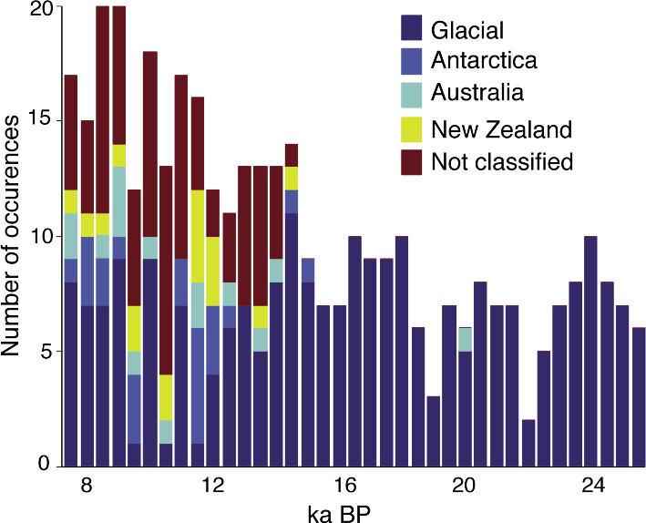
Figure 2: Histogram of REE patterns found in the EPICA Dronning Maud Land ice core over the last deglaciation, clearly demonstrating the appearance of non-glacial dust types after ~15 ka BP. REE patterns were statistically attributed to dust from Antarctica, Australia and New Zealand. Modified after Wegner et al. (2012). |
Wegner and colleagues have reported the concentrations of Rare Earth Elements (REEs) in various Antarctic ice cores (Gabrielli et al. 2010; Wegner et al. 2012). Comparable to the Sr, Nd and Pb isotopes, REEs are subject to fractionation as they have similar chemical properties but range in atomic weight from 139 (Lanthanum) to 175 (Lutetium). Consequently, the REE compositions differ between dust deflation zones due to their specific geochemical histories. Wegner and colleagues identified a “glacial” REE signature in the EDML ice core: In addition, they differentiated four other REE types, which were observed only during the deglaciation after ~15 ka ago (Fig. 2) and were attributed to dust from Antarctica, Australia and New Zealand.
Known unknowns of intercontinental dust transport
While there is only indirect evidence of early Holocene transport of Australian dust to Antarctica, unequivocal evidence of intercontinental dust transport in the late Holocene has been observed. Lead isotopic compositions in Law Dome ice show that anthropogenic Pb contamination of Antarctica began late in the 1880’s (Vallelonga et al. 2002). Lead isotopes showed the pollution source to be the Broken Hill mine in Southeastern Australia – one of the known dust deflation zones of Australia. Broken Hill Pb was released in the process of smelting Silver-Lead ores, first at Broken Hill (1887-1889) and later at Port Pirie in South Australia (1889 onwards). This demonstrates that aerosols can in principle be transported from Southeastern Australia to Antarctica, but the question remains as to whether anthropogenically-emitted Pb can be considered representative of naturally deflated mineral dust.
Some ways forward
Resolving the question of secondary dust sources in Antarctica is possible, but requires a cross-disciplinary approach, with further investigation of dust deflation zones, more precise analyses of dust in Antarctic ice, and enhanced understanding of the transport processes involved. Improved characterization of dust deflation zones will ensure that the source areas characterized accurately represent the deflated dust. Dust traps and airborne collection techniques can help with such efforts. Satellite observations can help understanding the dynamics of dust transport by tracking dust plumes from their continental sources all the way to Antarctica. New or improved analytical techniques may also enable better studies of the dust deposited in ice. Some techniques, such as REE or Pb isotope analysis, require larger datasets or more sensitive instrumentation, respectively. Finally, completely new approaches, such as Optically Stimulated Luminescence may offer a fresh approach to distinguish and apportion inputs of feldspar-rich SSA dust from quartz-rich Australian dust (Lepper et al. 2001).
data
Data presented in this article are available from the PANGAEA (www.pangaea.de) and NOAA paleoclimate (www.ncdc.noaa.gov/paleo) databases, except for the Vostok Pb isotope data (available from the author).
affiliations
Centre for Ice and Climate, University of Copenhagen, Denmark
contact
Paul Vallelonga: ptravisnbi.ku.dk
references
Full reference list under: http://pastglobalchanges.org/products/magazine/ref2014_2.pdf
De Deckker P et al. (2010) Palaeogeog Palaeoclimatol Palaeoecol 285: 205-223
Delmonte B et al. (2008) Geophys Res Lett 35, doi:10.1029/2008GL033382
Lambert F et al. (2008) Nature 452: 616-619
Bess G. Koffman1,2 and Karl J. Kreutz1
Dust flux and size distribution measurements from the West Antarctic Ice Sheet (WAIS) Divide and other non-East Antarctic plateau ice core sites suggest that local dust sources supply a significant amount of dust to the high-latitude atmosphere and ocean.
 |
|
Figure 1: Surface elevation map of Antarctica showing sites discussed in the text and annual average winds at 700 hPa (ERA-Interim climate reanalysis). Image obtained using Climate Reanalyzer (http://cci-reanalyzer.org). |
Polar ice is an important high-latitude archive of past environmental and atmospheric changes. The physical measurement of dust particles trapped in well-dated ice cores provides independent information, in the form of dust flux and particle size distribution (PSD) parameters, about past environmental changes in dust source regions, the proximity of dust sources, and variability in atmospheric circulation intensity. Much effort has gone into understanding the sources and transport of dust to the high-elevation sites (~3200-3500 m a.s.l.) Vostok and Dome C on the East Antarctic Ice Sheet (EAIS) plateau (Fig. 1). These records together provide a climatic history spanning the past eight glacial cycles (Lambert et al. 2008; Petit et al, 1999; Wolff et al. 2006). The East Antarctic plateau predominantly receives far-traveled dust, as evidenced by its lognormal distribution, small size (mode of 2 μm) and geochemical signature (e.g. Basile et al. 1997; Delmonte et al. 2004). The ice cores from this region provide invaluable information about hemispheric-scale changes in dust emissions and transport, but due to their high altitude, they do not capture dust carried in the lower-to-middle troposphere, and thus do not represent dust delivery to about half the Antarctic continent.
In order to assess changes in dust supply and transport to the lower-elevation regions of Antarctica, we must look to ice core records from West Antarctica and around the margins of the EAIS. Dust flux and particle size distribution measurements from WAIS Divide and other lower-elevation and coastal cores show that these sites receive both higher dust fluxes and coarser PSDs than the East Antarctic plateau cores. Accordingly, we infer that local dust sources supply a significant amount of dust to the atmosphere and ocean around Antarctica.
Higher dust fluxes near the Antarctic coast
Dust flux is measured in units of mass per area and time. It takes into account the possible dilution effects of the snow accumulation rate on aerosol deposition, and thus can be compared readily among sites and across time intervals. Changes in dust flux are considered to represent changes in atmospheric dust concentrations (Fischer et al. 2007; Wolff et al. 2006); therefore, flux measurements offer insight into the atmospheric dust burden and its potential impacts on climate.
 |
|
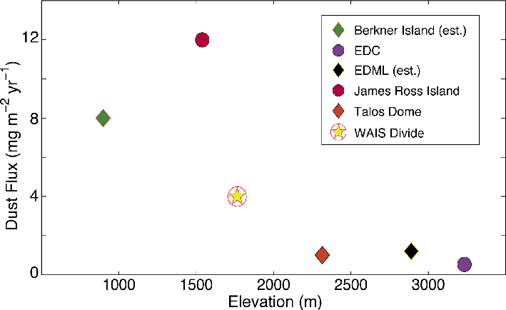
Figure 2: Dust flux versus elevation for: Berkner Island (Bory et al. 2010), EPICA Dome C (EDC; Lambert et al. 2012), EPICA Dronning Maud Land (EDML; Fischer et al. 2007), James Ross Island (McConnell et al. 2007), Talos Dome (Albani et al. 2012) and WAIS Divide (Koffman et al. 2014). Flux values for EDML and Berkner Island are estimated based on published flux ratios to other sites and available particle size information. |
During the late Holocene, dust fluxes measured at sites near the margins of the Antarctic ice sheet and at elevations below ~2500 m a.s.l. range from about 1-12 mg m-2 yr-1 (Fig. 2). This contrasts with the significantly lower fluxes well below 1 mg m-2 yr-1 measured at high-elevation East Antarctic sites. At WAIS Divide a background dust flux of ~3-5 mg m-2 yr-1 is punctuated by several particularly dusty intervals during the last two millennia, reaching peak fluxes of ~15-25 mg m-2 yr-1 (Koffman et al. 2014). At James Ross Island near the tip of the Antarctic Peninsula (1540 m a.s.l.), dust flux (calculated using aluminum concentrations) was found to be 12 mg m-2 yr-1 ca. 150 years ago, prior to the effects of land-use changes in Patagonia (McConnell et al. 2007). Near the Transantarctic Mountains at 2315 m a.s.l., the Talos Dome ice core yields a late Holocene dust flux of about 1 mg m-2yr-1 (Albani et al. 2012). While these records come from different sectors of the Antarctic continent and are almost undoubtedly influenced by different dust sources, they consistently show dust fluxes substantially higher than those seen on the East Antarctic plateau, where the interglacial dust flux is 0.2-0.6 mg m-2 yr-1 (Lambert et al. 2012). Corroborating these observations, Bory et al. (2010) report that the dust flux measured in modern snow at Berkner Island (899 m a.s.l.) in the Weddell Sea is about three times higher than at Kohnen Station in Dronning Maud Land (DML; 2890 m a.s.l.) for particles in the 5-10 μm range. Similarly, nssCa2+ fluxes (a common proxy for mineral dust in ice cores) measured in the EPICA (European Project for Ice Coring in Antarctica) DML ice core at Kohnen Station were found to be three times higher than those measured at Dome C, which is about 300 m higher and several thousand km further from Patagonian dust sources (Fischer et al. 2007). In short, during the late Holocene, sites from Antarctica show an inverse relationship between elevation and dust flux (Fig. 2).
These observations imply an elevational gradient in the atmospheric dust burden over Antarctica, with the ice sheet margins receiving about 1-2 orders of magnitude more dust than the East Antarctic plateau. Further supporting evidence comes from high and low iron flux measurements from coastal Law Dome and high-elevation Dome C in East Antarctica, respectively (Edwards et al. 2006). Observation of an elevational dust flux gradient within the EAIS confirms that observed flux differences across Antarctica do not relate to regional (e.g. WAIS vs. EAIS) differences. Instead, it seems likely that the higher fluxes at coastal sites and below ~2500 m elevation reflect greater proximal dust emissions activity, and possibly also higher deposition of far-traveled dust (e.g. from Patagonia and Australia). Today, about 2% of Antarctica is ice-free, comprising an area roughly the size of New Zealand (Campbell and Claridge 1987). Although much of this area consists of exposed bedrock, several regions with available fine-grained material could serve as dust sources.
Coarse particles imply local sources
Coarser particle sizes near the margin of the Antarctic ice sheet and at elevations below 2500 m a.s.l. further support that proximal dust sources play an important role. At WAIS Divide, the dust flux is dominated by particles in the 5-10 μm range, and the long-term (100 year average) mode size of the volume-weighted distribution is 5-8 μm diameter (Koffman et al. 2013). From the few sites in Antarctica where mode sizes have been reported, it appears that relatively coarse PSDs are a common feature of lower-elevation regions. For example, late Holocene dust deposited at Berkner Island and at Talos Dome is dominated by particles > 5 μm diameter (Albani et al. 2012; Bory et al. 2010). The high proportion of coarse particles contrasts with observations from the East Antarctic plateau, where the volume-weighted mode size is close to 2 μm diameter for both glacial and interglacial periods (Delmonte et al. 2002). Although very coarse (> 75 μm diameter) particles have been observed to travel distances greater than 10,000 km (Betzer et al. 1988), particles larger than 5 μm diameter generally are associated with short transport distances (e.g. Mahowald et al. 2013; Tegen and Lacis 1996), implying local sources of dust.
Conclusions
The observed differences in dust fluxes and PSDs between lower- and higher-elevation sites in Antarctica (e.g. below or above ~2500 m a.s.l.) indicate that locally sourced dust is transported too low to reach the East Antarctic plateau. Climate models suggest that dust originating from southern South America and Australia is transported at altitudes greater than 4000 m (Krinner et al. 2010), i.e. well above the Vostok and Dome C ice core sites (e.g. Basile et al. 1997; Delmonte et al. 2004; Revel-Rolland et al. 2006). In contrast, based on existing particle size measurements, we infer that dust from Antarctic ice-free areas is transported below ~2500 m. Additional PSD measurements from a range of elevations are needed to confirm this interpretation.
The relatively coarse PSDs at WAIS Divide and other sites below 2500 m a.s.l. are good evidence that Antarctic ice-free areas comprise active dust sources for the high-latitude atmosphere and ocean. While some areas, such as the McMurdo Dry Valleys, are known to be dusty (e.g. Bory et al. 2010), additional work is needed to understand the emissions activity and importance of Antarctic potential dust source areas, including the relative contributions of glacier-derived sediments and material of volcanic origin.
acknowledgements
This research was supported by NSF ANT-0636740 and ANT-1204050, and by the University of Maine Chase Distinguished Research Assistantship, Correll Graduate Student Research Fellowship, and Dissertation Research Fellowship to B.G.K.
data
The WAIS Divide ice core dust record can be obtained from the Global Change Master Directory (GCMD) public database.
affiliations
1School of Earth and Climate Sciences and the Climate Change Institute, University of Maine, Orono, USA
2Lamont-Doherty Earth Observatory of Columbia University, Palisades, USA
contact
Bess G. Koffman: bkoffmanldeo.columbia.edu
references
Full reference list under: http://pastglobalchanges.org/products/magazine/ref2014_2.pdf
Albani S et al. (2012) Clim Past 8: 741-750
Bory AJ-M et al. (2010) Earth Planet Sci Lett 291: 138-148
Delmonte B et al. (2004) Earth Sci Rev 66: 63-87
Stefania Gili and Diego M. Gaiero
Patagonian dust is the darling of researchers of paleoclimatic variability of southern South America. However, new chemical data from yet unexplored dust source areas allows for deeper investigation of the geological archives in the region.
In present-day southern South America (SSA) the major dust source areas are located in a continuous N-S band of arid and semi-arid terrains extending from the coastal regions of Peru to Patagonia. Three main persistent source areas stand out: Patagonia, Central-Western Argentina (CWA) and the Puna/Altiplano Plateau (Fig. 1). Multiple evidence indicates that these areas were continuously active over the last several glacial cycles.
Aeolian transport from Patagonia was often employed to explain the accumulation of the Pampean loess, the geochemical composition of sediment from the Southern Ocean and dust contained in Antarctic ice. However, chemical and isotopic fingerprinting methods has led to acceptance that Patagonian sediments can explain only part but not the entire range of compositions found in those archives. Other until now less considered but nevertheless important Southern Hemisphere regions were also important suppliers of dust during glacial-interglacial cycles. Current international efforts are dedicated to better characterize these non-Patagonian dust sources (e.g. De Deckker, this issue). Here, we present new geochemical data of sediments from potential source areas (PSAs) in SSA north of Patagonia.
Environmental setting of the PSAs
A climatic transition at ~38-39°S differentiates between regions dominated by summer rains to the north and winter rains to the south. South of this boundary lies Patagonia, a ~700,000 km2 area of drylands that extend down to Tierra del Fuego (~54°S). The atmospheric circulation there is dominated by strong meridional pressure gradients that promote strong Westerlies and high wind speeds year round. The Westerlies are associated with cold frontal systems that are capable of lifting dust high into the atmosphere. During glacial times these fronts were probably even stronger than today.
North of ~37°S the altitude of the Andes increases notably, disrupting the dominant zonal flow. East of the Andes lies the CWA region, a N-S oriented strip of drylands (36° to 26°S) encompassing the geomorphological domains of the Andean piedmont and the western Pampean ranges. Meridional surface winds dominate present and quaternary atmospheric circulation over the north and central sectors of this area. In the south (~34°S to 38°S), SW winds prevail today and also dominated in the quaternary as reconstructed in loess and sand fields studied in the western Pampean region (Muhs and Zárate 2001). The area is cut by several ephemeral streams that form extensive sand flats, saline marshes, and saline lakes. The whole sector is drained to the south by the hydrographic system of the Bermejo-Desaguadero-Salado River (~250,000 km2). A large volume of Andean sediments formed during the last glacial were transported by this hydrologic system to the south and then, once settled down, picked up by SW winds and transported to the northeast (Iriondo 1997).
The PAP area (~15°S to 26°S) is a high plateau (~4,000 m a.s.l). It consists of extensive, internally drained depocenters that contain large quantities of silt eroded from the surrounding N-S oriented mountain ranges. The region is influenced by the subtropical jet stream, which intensifies during the austral winter and can result in very strong winds that lead to sizable dust storms (Gaiero et al. 2013). Moreover, most of the Altiplano was repeatedly covered with paleolakes during the Late Quaternary, indicating alternating cycles of dry and wet conditions. In the Puna, evidence indicates large depressions of primary aeolian origin of likely Pliocene and early Quaternary age. From about 18°S to 26°S, sand dunes and windscoured ignimbrite ridges indicate a prevailing NW-SE wind direction during the late Pliocene and Pleistocene.
Chemical fingerprint of the PSAs
 |
|
Figure 1: Location of the main present-day dust sources in southern South America (black lines show the number of days with dust activity during a year; adapted from Prospero et al. 2002). Color dots indicate the position of collected surface sediments used to define the rare earth elements signature regions as shown in Figure 2. Yellow squares show the position of proximal aeolian (loess) records across the Pampas (Smith et al. 2003; Gallet et al. 1998). Inset: Distal aeolian records. Scotia Sea (white dots; Diekmann et al. 2000), and Vostock and Epica Dome C (black dots; EPICA community members 2006). |
Figure 1a shows the locations where we collected surface sediment from arid and semiarid terrains (colored dots). Sampling locations were selected based on direct field evidence of dust activity and dust storms identified on satellite images. Sediment samples were taken from intermountain closed basins from a range of desiccated lake edges, fluvial-alluvial fans and enclosed basins.
 |
|
Figure 2: (A) Colored areas represent the rare earth elements (REEs) signature of the main potential dust sources in southern South America as inferred from surface sediments (Fig. 1). The yellow squares show the chemical composition of Pampean loess sequences (1, 2, 3, 5 and 6 from Smith et al. 2003; 4 from Gallet et al. 1998). (B) Comparison with distal geological records: sediments from the Scotia Sea and dust from East Antarctica (Basile et al. 1997; Diekmann et al. 2000). Autstralian sediments data from Gingele et al. 2007. |
Rare earth elements (REEs) analyses were run on <63 and <5 µm grain-size fractions of sediments. This group of elements is a very useful tool in sediment provenance studies because REEs inherit the composition of their sources. LaN/YbN ratios and Eu/Eu* anomalies turned out to be particularly sensitive parameters for the recognition of PSAs. Based on these parameters it was possible to single out five PSAs (Fig. 2).
SSA dust in geological archives
The Pampean region is a large area (~106 km2) covered with a 20-50 m thick loess cover. It represents the proximal geological record of dust activity in SSA to the sources to the West. The chemical composition of loess sequences collected from sections 1-5 (Fig. 1), can be reconciled with the chemical composition of the non-Patagonian PSAs (Fig. 2A). The southernmost section (6) has a clear Patagonian signature, while the chemical fingerprint of the southern CWA prevails over the loess sections located further north (2, 3 and 5). The provenance of aeolian materials in section 1 (~2,000 m a.s.l) is contentious; for this area chemical data have the largest variability. From a mechanistic perspective, the Puna sector seems to be the most likely source because dust can be transported from there by upper tropospheric air masses. Unexpectedly, loess samples from section 4 are chemically different from samples from the nearby sections 3 and 5.
The chemical signature of dust from SSA can also be recognized in distal geological archives. Figure 2B shows that the chemical composition of glacial-interglacial sediments deposited in the Scotia Sea, to the south-east of SSA, match well with the Patagonian signature and, to a lesser extent, with materials derived from the southern CWA. Notably, an important number of interglacial samples from the Scotia Sea fall within the compositional area corresponding to Puna surface sediments. The interpretation of the source of dust deposited in East Antarctica is more ambiguous as the chemical composition of four of the six samples also match the chemical composition of some surface sediments from Australia.
Implications for further research
The sediments from the PSAs of SSA have relatively distinct REE chemical compositions, which is a good prerequisite for a reliable paleo-climatic interpretation of the dust records of the SH. Our new data set from surface sediments suggests that most of the continental sediments deposited during glacial-interglacial periods in the Scotia Sea and the Pampas have REE comprised mostly of a mix of Patagonian, southern CWA and Puna origin. Contrary to other evidence, chemical data suggest that southern Altiplano sediments play a minor role in the composition of these materials. The provenance of dust in East Antarctica is ambiguous, because the chemical REE composition is similar to Australian sediments as well as some of the PSAs in SSA. Therefore, other methods are required to unambiguously attribute East Antarctic dust to a provenance.
The possibility of distinguishing all these signatures in paleo-dust archives could be important to improving our understanding of the major atmospheric circulation patterns during the last glacial-interglacial cycles, such as understanding the equatorward and poleward displacements of the Westerlies and the subtropical westerly jet stream during the past climatic cycle. To achieve this, higher temporal resolution studies with appropriate age controls of Pampean loess sequences are required. Moreover and in addition to the REEs approach, more detailed analysis of the geochemistry (e.g. Sr, Nd, Pb isotopes) and mineralogy of surface sediments from SSA and Australia are needed.
affiliations
Center for Earth Science Research, National University of Cordoba, Argentina
contact
Stefania Gili: sgiliefn.uncor.edu
references
Full reference list under: http://pastglobalchanges.org/products/magazine/ref2014_2.pdf
Diekmann B et al. (2000) Palaeogeogr Palaeoclimatol Palaeoecol 162: 357-387
Gaiero DM et al. (2013) J Geophys Res Atmos 118: 3817-3831
Iriondo M (1997) J S Am Earth Sci 10: 71-77
Muhs D, Zarate M (2001) In: Markgraf (Ed) Interhemispheric Climate Linkages, Academic Press, 183-216
Patrick De Deckker
Methods to identify airborne material in deep-sea sediment cores and track dust provenance are reviewed here. An example from Australia demonstrates how evidence from Sr and Nd isotopes and rare earth elements can reveal the climatic history with sub-regional detail.
The quest to identify the aeolian component among the terrigenous material deposited at sea relies on a whole suite of techniques that can be applied to determine the presence of airborne dust in deep-sea sediment cores and to track its origin:
(1) The percentage of the quartz fraction in sediment cores from the deep ocean and the continental shelves gives an indication of the airborne fraction, based on the assumption that the quartz particles were wind blown. This approach was first applied by Thiede (1979) in the Tasman Sea, east of Australia.
(2) The size of quartz grains and their texture, i.e. the pitted depressions of desert sand grains from collisions during saltation, contain information on wind speed, the degree of storminess, and the distance traveled from land. Rea and colleagues used such an approach in sediment cores from the northwestern and central Pacific Ocean (Janecek 1985; Rea 1990, 1994).
(3) The proportion of different clay species can reflect the mode of sediment transport. Comparison of the clay composition in deep-sea sediment cores with clays from nearby rivers and dune fields can provide a quantitative measure for the relative importance of fluvial and aeolian transport. Such an approach was performed by Gingele et al. (2001) who differentiated riverine from airborne clays offshore northern Australia.
(4) Using the same approach and samples as Gingele et al. (2001), Ehlert et al. (2011) were able to consolidate the previous findings using a combination of Pb, Nd and Sr isotopes. In this latter study, Ehlert et al. (2011) were able to identify the origin of fluvial clays and define patterns of oceanic currents at the sea surface during and after the Last Glacial Maximum.
(5) Rare earth elements (REE) in deep-sea core sediments. The REE composition and geochemistry is specific to each ablation area. This REE signature can help identify the origin of the material deposited at sea. (See example below on the use of Yttrium).
(6) Sr and Nd isotopes from regolith samples such as in Australia can help constrain the origin of the deep-sea sediments provided there is sufficient information on the composition of the regolith that can potentially supply material at sea, either airborne or by fluvial discharge.
(7) X-ray fluorescence scanning of soft marine sediments at a centimeter to sub-millimeter scale for a variety of elements (see Weltje and Tjallingii 2008) can be used to estimate the relative contributions of fluvial and aeolian material. Some elemental ratios such as K/Ca and Rb/Ca relate to continental weathering whereas others such as Ti/Ca, Si/Ca and Zr/Ca relate to an aeolian component. This was recently demonstrated for a core taken offshore northwestern Western Australia by Stuut et al. (2014).
Application to marine sediments off Australia
 |
|
Figure 1: Illite and yttrium concentrations in sediment core MD03-2611 offshore Kangaroo Island for the last 17 ka. The horizontal line shows the illite percentage at the mouth of the Murray River today. The two illite peaks around 14-12 ka and 10-8 ka represent significant water discharge from the eastern highlands of SE Australia. The yttrium increase shows a change to predominantly aeolian sediment supply after 6 ka. |
Deep-sea sediment core MD03-2611 was taken offshore South Australia, opposite the mouth of the Murray River that together with the Darling River system drains the extensive (1.106 km2) Murray Darling Basin (map in Fig. 1). De Deckker et al. (in press) analyzed selected samples from that core with several of the methods listed above to constrain the chemical signature of various parts of the Australian regolith.
 |
|
Figure 2: Plot of Sr and Nd isotopes for sediment core MD03-2611 (red dots) and from regolith samples in eastern and central Australia that are considered potential sources of airborne dust. Blue dots represent tributaries of the River Murray and Darling River. The Nd isotopic ratios above 0.51255 pertain to Darling River tributaries that share similarities with samples from the Lake Eyre region (orange triangles). Black squares represent samples from west and east of the Flinders Ranges and from western New South Wales near Broken Hill. The samples aged >11 ka BP come from the Murray sub-basin and would have been transported to the core site by water (thus being river borne), whereas the younger samples come from central South Australia and western New South Wales, and are considered to have been airborne, being from outside the Murray Darling Basin. |
The relative abundance of the clay species illite, smectite, and kaolinite, combined with Sr and Nd isotope ratios of the clay fraction (Gingele et al. (2007) revealed the flooding history of the Murray Darling Basin. Clay speciation (Fig. 1) varied substantially over the last 17 ka. The surprise was to find a drop in illite content during the Holocene, which indicates prevalence of an aeolian component from a remote source during the last 6 ka, since what was recognized as the clay sediments did not pertain to the Murray Darling Basin. This period of aeolian activity is also recognized in the Sr and Nd isotope records (Fig. 2). The history of increasing supply of airborne sediment paralleled a progressive sea-surface cooling determined by alkenone chemistry carried out on the same sediment core (Calvo et al. 2007).
The increase in the concentration of the REE yttrium following 6 ka BP also points to a fundamental change in the supply source of terrigenous material to the core site (Fig. 1). Furthermore, Sr and Nd isotopes compared to the Australian regolith constrain the origin of the sediments in core MD03-2611. Figure 2 shows the spread of Sr and Nd isotopes for different regions in the southeastern sector of Australia, all of which are considered potential dust sources (De Deckker et al., in press). Sr and Nd ratios in core MD03-2611 suggest that prior to 10 ka BP the sediment originated from the Murray sub-basin, after that from regions outside the Murray Darling Basin. Likely distal sources are central South Australia and western New South Wales, implying an aeolian transport mechanism to the sediment core site.
Conclusion
An array of traditional and new approaches for studying sediments in marine sediment cores can fingerprint the origin and indicate the transport mechanism of the terrigenous material deposited at sea. Methods include clay speciation and the chemical composition of the clay fraction such as Sr and Nd isotopes and REE. Core scanning that allows us to determine various elements at high resolution (but not in a quantitative way) also provides a new tool for distinguishing aeolian from fluvial components. The scanning method is non-destructive, relatively inexpensive and rapid and, therefore, can inform us which analytical techniques are best applied to identify the airborne fraction of marine and other sediments.
affiliations
Research School of Earth Sciences, The Australian National University, Canberra, Australia
contact
Patrick De Deckker: patrick.dedeckkeranu.edu.au
references
Full reference list under: http://pastglobalchanges.org/products/magazine/ref2014_2.pdf
De Deckker P et al. (in press) Aeolian Research, doi:10.1016/j.aeolia.2014.07.003
Ehlert C et al. (2011) Geochem Geophys Geosyst 12, doi:10.1029/2011GC003544
Gingele FX et al. (2007) Earth Planet Sci Lett 255: 257-272
Stuut JB et al. (2014) Quat Sci Rev 83: 83-94
Weltje GJ, Tjallingii R (2008) Earth Planet Sci Lett 274: 423-438