PAGES Magazine articles
Thomas Hoffmann1, D. Penny2, V. Vanacker3, G. Stinchcomb4 and Lu Xixi5
Bonn, Germany, 19-21 August 2015
The aim of the open kickoff meeting of the PAGES working group GloSS was to set the boundary conditions for GloSS to meet its scientific goals within the next three years. The workshop focused on the development of a list of proxies and indices of human impacts on soil and sediment transfers that will support the compilation of a global soil and sediment database.
 |
|
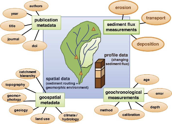
Figure 1: Planned structure of the global GloSS database focusing on human impact on soil erosion, sediment transport and deposition during the Holocene. |
A total of 30 participants from different disciplines (geomorphology, geology, soil science, ecology, (paleo)limnology, hydrology, and geoarcheology) and four continents contributed to the workshop.
The first one and a half days were dedicated to continental reviews of proxies of human impacts on soils and sediment transfers. The regional reviews were complemented by a keynote, which provided a global view on sediment production and export, and a videoconference contribution on the experiences of the PAGES 2k-team building the PAGES 2k database.
During the second and third days, the workshop participants (i) developed a concept to organize proxies of human impact on soil and sediment dynamics for hillslopes, floodplains, lakes, and deltas covering different timescales during the Holocene, (ii) discussed the structure, requirements, and potential stakeholders of a GloSS database, and (iii) developed a project road map for the next three years.
The participants of the breakout discussion group on human impact proxies agreed that the first version of the dataset should only include proxies and indices of soil erosion and of sediment transport and deposition. Other proxies such as pollen or diatoms, which are not directly related to sediment transport, will not be included. While quantitative volumetric and mass balance proxies are generally favored compared to length-per-time proxies (such as sedimentation or erosion rates given in mm per year), it was nevertheless noted that the latter are invaluable for reconstructing sediment budgets and that for many study sites complete quantitative inventories are not available. Despite their limitations, length-based rates data will also be collected, but will be interpreted with care due to timescale biases that arise from comparing datasets that average over different timescales. Regarding the considered timescale, the Holocene was considered to be the adequate time frame for the GloSS datasets, as it allows the study of anthropogenic disturbances as well as natural baseline conditions.
The discussion on the GloSS database content and structure resulted in the following statement: The database should focus on soil erosion and sediment transport and deposition of hillslopes, floodplains, and channels, lakes, and deltas (Fig. 1). At this point, there is no need to populate the database with other available paleo-environmental information. Instead, the database should be linked to other existing databases to avoid redundancy where possible.
The participants agreed that human impact on the above-mentioned environments is best described by the changes in erosion, transport, and deposition. Thus, at minimum, two time slices, before and after human impact for those three variables, are necessary. Due to the major challenges of defining what human impact actually is and when it starts in different regions of the earth, it was argued that the number of time slices should be larger to allow flexible interpretations without constraining what the user can interpret from inferred changes (e.g. climate versus human impacts).
To set the boundary conditions for the first three years of the GloSS working group, a roadmap, seven regional task forces, and a database task force were built.
The regional task forces and their leaders are: Europe and Mediterranean (Gert Verstraeten), South Asia (Rajiv Sinha), SE Asia (Dan Penny), Australia and New Zealand (Bob Wasson, Duncan Cook), East and Central Asia (Hongming He, Lu Xixi), North America (Jane Willenbring, Gary Stinchcomb), South and Central America (Juan Restrepo), and Africa (Klaus Martin Moldenhauer, to be confirmed).
The database task force includes Jane Willenbring, Gary Stinchcomb, Veerle Vanacker, Dan Penny, Lishan Ran, Jean Philippe Jenny, Nick Mackay, Kim Cohen, and Thomas Hoffmann.
If you would like to participate in any of these activities, visit the GloSS webpage at pastglobalchanges.org/science/wg/former/gloss/intro
affiliations
1Department of Geography, University of Bonn, Germany
2School of Geosciences, University of Sydney, Australia
3Earth and Life Institute, Université catholique de Louvain, Louvain-la-Neuve, Belgium
4Department of Geosciences, Murray State University, Murray, USA
5Department of Geography, National University of Singapore, Singapore
contact
Thomas Hoffmann: thomas.hoffmann bafg.de
Sarah Gille1, J. Jones2 and H. Goosse3
La Jolla, USA, 24-26 March 2015
Given the short length of the observational record at the high latitudes of the Southern Hemisphere, modern instrumental data are not sufficient to describe the regional state and variability of the climate system. Data rescue of early observations, instrumental data, and proxy records are needed even more here than in other regions. Furthermore, the links between atmosphere, ocean, and sea ice are strong in the southern polar region. The objective of this workshop was to study changes in large-scale patterns of Antarctic climate variability over the last decades to centuries, as well as extrapolar-polar connections, by combining proxy records, historical data, and instrumental records that cover the atmospheric, land, and oceanic domains, with model results.
The workshop was attended by an international group of 30 scientists, including early-career scientists. It brought together expertise from the atmosphere, ocean, and sea ice communities, along with expertise in satellite, observational, historical and paleoclimate data, and modeling. It was jointly supported by PAGES and the World Climate Research Programme (WCRP) as part of the WCRP Polar Climate Predictability Initiative (PCPI). The PCPI has a focus on polar regions and their role in the global climate system, and aims to improve predictability of the climate system on all timescales by improving understanding of the underlying physical mechanisms and their representation in climate models.
 |
|
Figure 1: Location and type of climate and environmental information covering the last 200 years in Antarctica (Figure from Nerilie Abram). |
After reviewing our current knowledge, participants focused on discussing the difficulty in determining the magnitude and causes of decadal-scale variability in climate system changes in the Southern Ocean and Antarctic region. For example, for data types such as those indicated in Figure 1, we considered how to determine whether trends in recent decades are unprecedented or within the range of natural variability. These difficulties are both due to our incomplete understanding of the dynamics of the system and the lack of data. In particular, modern instrumental records in the ocean typically represent isolated point observations, not extended time series, and these records extend back only a few years. Furthermore, paleoclimatic records of sufficiently high resolution are scarce. This severely limits our ability to estimate the natural multi-decadal variability.
Participants found the workshop to be stimulating and would definitely encourage similar jointly supported PAGES and WCRP activities in the future. Workshops such as these provide a rare opportunity for communities that do not normally meet (paleoclimate, instrumental, modeling) to share their expertise covering all aspects of the problem (atmosphere, ocean, sea ice) and to focus on specific issues. Data scarcity was recognized as a crucial limitation for Southern polar climate studies, and the importance of new work that needs to be done to obtain data for oceanic areas in the Southern Hemisphere was stressed, namely by developing new proxies using cold corals and mollusks, and also by imaging, digitizing, and processing meteorological observations from ships’ logbooks. The need for better estimates of the uncertainties in current reanalysis products and for a coupled reanalyses dataset focused on high southern latitudes were also underlined.
The meeting achieved its aims of taking stock of current knowledge and determining key questions. Participants developed concrete plans for a publication summarizing the meeting findings. The meeting also sowed the seeds for a number of future collaborations, and we have been working to collect information about these emerging collaborative efforts, which we would be happy to share.
affiliations
1Scripps Institution of Oceanography, University of California San Diego, USA
2Department of Geography, University of Sheffield, UK
3ELIC/TECLIM Unversité catholique de Louvain, Belgium
contact
Sarah Gille: sgilleucsd.edu
Gaylen Sinclair1, B.S. Lecavalier2 and K.L. Vyverberg3
PALSEA2 Workshop, Tokyo, Japan, 22-24 July 2015
In July, the third meeting of the second PALeo constraints on SEa level rise (PALSEA2) working group convened at the University of Tokyo, with the goal of integrating data and model-based reconstructions of paleo climate, cryosphere, and sea level. Presentations focused on past warm periods (mainly the late Pliocene, the last interglaciation (LIG), and the Holocene) and periods of rapid change during the last glacial cycle.
 |
|
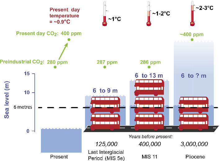
Figure 1: Summary figure of global mean sea level during past warm periods, global mean temperature relative to 1890 CE, and atmospheric CO2 levels. Adapted from Dutton et al. (2015) |
Due to the fragmentary record of the Miocene and Pliocene, and chronological uncertainties with existing records, delegates agreed that obtaining accurate sea-level rates for this period is impossible; efforts should focus on better constraining the maximum amplitude (Fig. 1). Sea-level changes due to dynamic topography must also be considered at these timescales to accurately estimate global ice volume from the sea-level reconstructions; current model results show that the contribution from this process can be tens of meters and may account for the spatial variations in Pliocene sea-level fluctuations (Rovere et al. 2015).
For the LIG, model-corrected relative sea-level records indicate peak global mean sea levels of around six to nine meters (Fig. 1), although the timing and number of highstands differs between reconstructions. In several areas, including the Seychelles, detailed study of fossil coral facies and lithology reveal sub-orbital sea-level fluctuations consistent with previous inferences from the Bahamas and the Red Sea (Thompson et al. 2011; Rohling et al. 2008). A single, global-mean sea-level reconstruction should enable eventual reconciliation of these disparate sea-level estimates, accounting for different sources of sea-level rise, including potentially different timings of retreat of the major ice sheets.
The Holocene sea-level history is relatively well constrained, although there is room for improvement in delimiting the spatial and temporal variability of sea levels. A primary source of uncertainty is the contribution from the Antarctic Ice Sheets due to the relative paucity of observational control and the difficulty in obtaining accurate dates from cosmogenic methods. For the past 2,000 years, application of a Gaussian process model supports the existence of sub-millennial changes in global mean sea level (Cahill et al. 2015); but the processes responsible for those changes remain a target for future research.
Several techniques for improving climatic forcings in models were also debated, highlighting differences between modeled LIG climates and compilations of ocean-temperature data. Coupling of ice-sheet and climate models is increasingly feasible, and critical for understanding reconstructed sea-level histories. The importance of developing transient simulations of past warm periods was stressed as a means to improve understanding of the spatial and temporal variability observed in ice-sheet and sea-level reconstructions.
While new paleoclimate data at present are often archived online, they are rarely compiled into intuitive databases that can be easily accessed by all end users, particularly the modeling community. Significant progress has been made since the last PALSEA2 meeting in developing a framework for new databases for use by paleoclimate and paleo sea-level communities (Düsterhus et al. 2015). Discussions continued at this meeting, where delegates stressed the importance of including all metadata for a given data point to facilitate standardization of data and accommodation of future interpretations and calculations. Discussions during the conference to clarify the uncertainties of various data and model outputs highlighted the importance of being more rigorous about reporting and explaining uncertainties. Such transparency will facilitate the interpretation and application of climate, cryosphere, and sea-level reconstructions, and will be critical to advancing data-model comparisons, as well as interdisciplinary collaborations.
acknowledgements
Funding was provided from PAGES, INQUA, and the Atmosphere and Ocean Research Institute (AORI) at the University of Tokyo. We thank all the delegates and the local hosts – Yusuke Yokoyama, Ayako Abe-Ouchi and their research groups – for making the workshop a success.
affiliations
1College of Earth, Ocean, and Atmospheric Sciences, Oregon State University, Corvallis, USA
2Department of Physics and Physical Oceanography, Memorial University of Newfoundland, Canada
3Department of Geological Sciences, University of Florida, Gainesville, USA
contact
Gaylen Sinclair: gsinclaircoas.oregonstate.edu
references
Cahill N et al. (2015) Ann Appl Stat 9: 547-571
Düsterhus A et al. (2015) Clim Past Discuss 11: 2389-2404
Dutton A et al. (2015) Science 349: 153
Rohling EJ et al. (2008) Nature Geosci 1: 38-42
Jesse Morris1,2, J. Clear3, S. Cottrell4, W. Hansen5, K. Mattor4, A. Seddon6 and H. Seppä7
Santa Fe, USA, 2-3 April 2015
Since the late 1980s, native bark beetles (Curculionidae: Scolytinae) have caused widespread tree mortality in forests throughout North America and Europe. From a historical perspective the spatial scale and intensity of this disturbance has never been observed before. The outbreaks have been attributed to warm and dry climate conditions, which accelerate beetle reproduction cycles and diminish host tree defenses. During the past two decades, over 47 Mio ha of coniferous forest have been affected in western North America (Raffa et al. 2008).
An international group of ecologists and social scientists concerned with bark beetles met to identify priority research questions about the past, present, and future dynamics of beetle infestations, and the implications for society and the environment. The workshop ran alongside the Western Forest Insect Work Conference (www.wfiwc.org) in which all of the 17 workshop participants gave a short-format oral presentation. These research talks facilitated rich discussions among participants and representatives of several land-management agencies, including the US Forest Service and US Fish and Wildlife Service.
The workshop discussions addressed several major research themes pertaining to the social-ecological dimensions of bark beetle disturbances:
1) Ecological impacts
Tree mortality in western North America has been caused primarily by the mountain pine beetle (Dedroctonus ponderosae) and spruce beetle (D. rufipennis), while in Europe the spruce bark beetle (Ips typographus) has been most active. A key discussion point was how best to determine the precedence of recent outbreaks through the analysis of lake sediment and peat records. Discussions centered on applications of pollen, non-pollen palynomorphs, insect macrofossils, and biogeochemical proxies to detect past outbreaks with an emphasis on integrating sediment proxies with tree-ring records and forest inventories (Morris et al. 2015).
2) Ecosystem services
Ecosystem services provide a variety of important benefits to society, though many of these services remain unquantified. Severe beetle outbreaks pose challenges to society, including harmful effects on human health due to diminished air and water quality, by shifting property values, by causing declines in merchantable timber, and by negatively affecting landscape aesthetics causing reductions in tourism revenues (Flint et al. 2009). However, bark beetle disturbances can also lead to increases in the provision of ecosystem services, including improved wildlife viewing and increases in stream flow. These costs and benefits must be managed and measured in the face of change through strategies designed to improve and facilitate resilience (sensu Hollings 1973) and the adaptive capacity of the system. Workshop discussions aimed to identify common metrics, such as carbon biomass, that could aid in assessing the impacts and recovery of ecosystems from beetle disturbances over multiple spatial and temporal scales.
3) Human behavior
 |
|
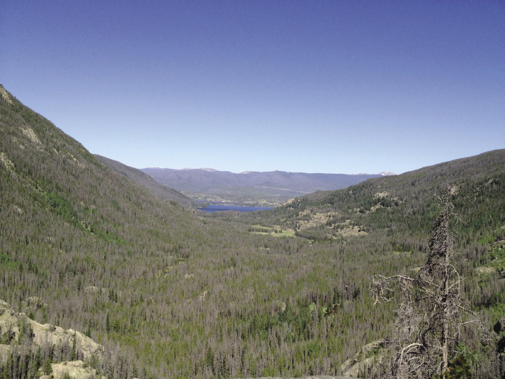
Figure 1: View of gray stage lodgepole pine forest, or “ghost forest”, resulting from a mountain pine beetle outbreak in the Rocky Mountains, USA. |
Of particular interest was how human perspectives shape policy and management response to large-scale outbreaks. For instance, recent studies demonstrate that beetle-impacted forests do not increase fire hazard, yet US management policies still allocate hundreds of millions of dollars annually to reduce fuel loads in beetle-affected forests (Hart et al. 2015). Additionally, changing property values are of concern as communities that were once surrounded by lush forests now find themselves in expansive landscapes of gray, standing dead trees known as “ghost forests” (Fig. 1). However, following salvage logging operations some communities surprisingly realize net increases in real estate values due to enhanced viewsheds (Hansen and Naughton 2013).
Priority research questions identified at the workshop will provide the basis for a forthcoming journal article and a research proposal planned for fall 2015 submission.
acknowledgements
This workshop was supported through a PAGES workshop award. Additional support was provided by the Mountain Social Ecology Observatory Network funded by a US National Science Foundation award No. DEB-1231233.
affiliations
1Department of Forest, Rangeland, and Fire Sciences, University of Idaho, Moscow, USA
2Department of Geography, Kansas State University, Manhattan, USA
3Department of Forest Ecology, Czech University of Life Sciences, Prague, Czech Republic
4Warner College of Natural Resources, Colorado State University, Ft. Collins, USA
5Department of Zoology, University of Wisconsin, Madison, USA
6Department of Biology, University of Bergen, Norway
7Department of Geosciences and Geography, University of Helsinki, Finland
contact
Jesse Morris: jlmorrisuidaho.edu
references
Flint C et al. (2009) Environ Manage 43: 1174-1186
Hart S et al. (2015) Proc Nat Aca Sci 112: 4375-4380
Hansen W, Naughton H (2013) Ecol Econ 96: 141-154
Holling CS (1973) Ann Rev Ecol System 4: 1–23
Jeffers E et al. (2015) Quat Sci Rev 112: 17-32
Marcel Mîndrescu1,2 and Ionela Grădinaru1,2
CBW2014, Cluj-Napoca, Romania, 6-9 November 2014
Prior to the last decade, the Carpathian region was largely unrepresented in large data reviews (Akinyemi et al. 2013) on well-dated, high-resolution investigations of past climate and environmental conditions and in studies on human impact on the local and regional environment. However, more recently, as new paleoclimatic records are continuously being generated, the area has ceased to be regarded as a blank spot in regional and continental-scale climate reconstructions (e.g. Feurdean et al. 2014). Undoubtedly, improving knowledge of the region in terms of past and current climate change research, biodiversity patterns and dynamics, or human spread and related cultural-technological interchanges will be accomplished only through a denser network of multi-proxy investigations (Veres and Mîndrescu 2013).
In 2011, a workshop co-sponsored by PAGES and the Mountain Research Initiative (MRI), and focusing on climatic variability in the Carpathian-Balkan region (Carpathian-Balkan Workshop, CBW2011, Suceava, Romania) was an early and successful attempt to create a network of paleoscientists in the region (Mîndrescu 2012). An initial product from this new network was a special volume in Quaternary International on the advances in Pleistocene and Holocene climate changes research from the Carpathian-Balkan region (Veres and Mîndrescu 2013).
The latest workshop, CBW2014, was another step forward for paleo-research in the region. The outcomes of several collaborations emerging from CBW2011 were presented, and new international research topics were discussed. Furthermore, the event provided a platform for young scientists to introduce and discuss their results to an international and multidisciplinary audience.
Sixty-two researchers from 11 countries (Canada, UK, Switzerland, Germany, Poland, Hungary, Ukraine, Bulgaria, Bosnia and Herzegovina, Serbia, and Romania) conducting studies in the Carpathian-Balkan region presented over 60 contributions covering the timeframe from the Late Pleistocene to the present. Topics included climate and vegetation changes inferred from lacustrine and riverbed sediments, tree rings, speleothems, loess-paleosol sequences, and glaciers and glaciation; refining research techniques for paleoenvironmental investigations; human impacts; archeological findings; etc. The abstracts and extended abstracts were published prior to the event in an open-access special issue of Georeview (http://georeview.ro/ojs/index.php/revista/issue/view/CBW-2014).
 |
|
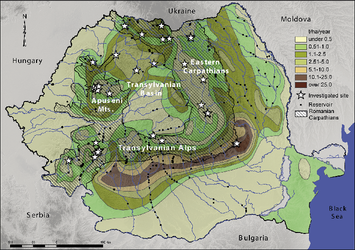
Figure 1: Location of sites with lacustrine sediment records in the Romanian Carpathians (modified from Mîndrescu et al., in press). |
The range of data from recent research in the region presented at the workshop (including two datasets on glacial lakes, http://atlas.usv.ro/geoconcept/webcarpath2/ and glacial cirques from the Romanian Carpathians, http://atlas.usv.ro/geoconcept/glaciar/) is in itself an accomplishment as those records contribute in covering previously “uncharted” territory. Further, the meeting participants envisaged using the new datasets as a basis for new research endeavors which could integrate and relate data from this growing network of sites (see Fig. 1).
The more advanced contributions presented at the meeting will be published in a special volume in Quaternary International, to be guest edited by the organizers of the workshop: more than 30 author groups have already committed to submitting a paper.
Finally, in the plenar discussion, the participants agreed that without better data coverage and expertise exchange, difficulties will remain in understanding local-scale environmental changes and developing regionally significant paleoclimate reconstructions, which would assist in proposing plausible predictions of future climate evolution.
affiliations
1Department of Geography, University of Suceava, Romania
2Geoconcept Association of Applied Geography, Suceava, Romania
contact
Marcel Mîndrescu: marcel.mindrescugmail.com
references
Akinyemi FO et al. (2013) Quat Int 293: 105-113
Feurdean A et al. (2014) Quat Sci Rev 106: 206-224
N’dji dit Jacques Dembele
Bamako, Mali, 27-31 October 2014
 |
|
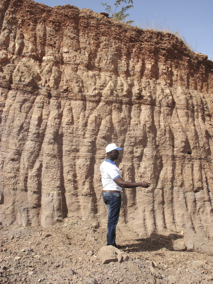
Figure 1: Laminated lacustrine deposits of the Niger River south bank at Bamako, Mali, visited during the conference field trip. |
The West African Quaternary Research Association (WAQUA) was established in 2009 to promote Quaternary Sciences in the West African region through the capacity building, mentoring and motivation of early-career scientists and the fostering of collaborative research, exchange of information and networking opportunities. Eighty quaternary scientists, mainly early-career scientists of the West African region and Democratic Republic of Congo, gathered in Bamako to share their research results and experiences on quaternary fluvio-lacustrine environments.
Fifty oral presentations were given in the following five sessions: (1) Quaternary fluvio-lacustrine sediments: paleoclimates and paleoclimatology; (2) Past and contemporary human settlements in relation to fluvio-lacustrine systems; (3) Paleoecological evidences from fluvio-lacustrine deposits; (4) Current environmental issues arising from the use of fluvio-lacustrine systems; (5) The methods of research of quaternary fluvio-lacustrine complexes in West Africa.
During the first session, the fluvio-lacustrine deposits of the Niger River in Mali and in Nigeria; the stratigraphy of fluvial deposits of the Falemé River, tributary of the Senegal River; and the paleoenvironment and paleoclimates of the Kivu River in the Democratic Republic of Congo during the late Pleistocene and Holocene were introduced. This session showcased the great potential to use fluvial deposits to reconstruct the quaternary climatic variation and paleohydrology of West Africa. However, because the scientists in that region do not use the same stratigraphic framework, comparing the individual studies is difficult. Building such regional comparable chrono- and climatostratigraphies is only possible through collaborative research efforts. In the discussion, the participants also agreed that local stratigraphic climatic stages such as the Ogolian (a dry period of the late Pleistocene) could not be generalized to all of West Africa without further research and stratigraphic correlation.
During the second session, the prehistoric settlement of the Sahelian region of West Africa in Burkina Faso, in the Niger Inland Delta region and in Nigeria; the Holocene settlement of the Dogonland of Mali; and the effect of current climate change on migration were presented. The discussion focused on the effect of quaternary climate variability on human settlements and population migrations. The participants recognized that understanding quaternary climate variation, and especially the succession of dry and humid periods, should be one of the foci of quaternary research in the region.
The third session covered the evolution of quaternary vegetation in the Niger Inland Delta in Mali and in Nigeria and an explanation of the causes of the “Dahomey Gap”, a region of savanna separating the West African tropical forests. Pollen analyses provide evidence of the effect of climate change and human settlement on West African ecosystems. The attendees recommended the use of more paleoecological research methods such as phytoliths and quaternary fossil assemblages analyses to complement pollen analysis.
The fourth session focused on the impacts of current climate change on the West African fluvial and lacustrine ecosystems; anthropogenic pressure; the use and management of fluvial and lacustrine resources; flash floods; the use of fluvial and lacustrine systems for tourism; and the impact of off-season rainfalls. In this session’s discussion, the use of the concept of “climate change” was discussed and whether one can talk of climate change or climate variability in only a 30-year framework. Climatologists of the region were asked to address this question by providing a temporal perspective on the use of these two concepts in the West African context.
During the last session quaternary research methods in the West African fluvio-lacustrine context were discussed. Methods based on pollen analysis, computer modeling, and GIS were introduced.
To help the early-career scientists improve their research capacity, training sessions were organized on the topics “Paleoecology and palynology of quaternary fluvio-lacustrine deposits” and “The use of heavy minerals in quaternary fluvial and lacustrine deposits, and in geoarcheology”.
acknowledgements
The organizing committee express their sincere gratitude to PAGES, INQUA, PAST (Palaeontological Scientific Trust), AUF (Agence Universitaire de la Francophonie), and USSGB (Université des Sciences Sociales et de Gestion de Bamako) for their financial and material support, and encouragement.
affiliation
Faculty of History and Geography, University of Social Sciences and Management of Bamako, Mali
contact
N’dji dit Jacques Dembele: ndjijacquesicloud.com
 |
Sonia L. Fontana1 and Keith D. Bennett2
Mar del Plata, Argentina, 4-15 August 2014
The 2nd Latin American paleoecology workshop took place at the University of Mar del Plata, Argentina and was attended by 37 participants from Mexico, Ecuador, Colombia, Brazil, Chile, Uruguay and Argentina. This intensive two-week course was designed for postgraduate students and early-career scientists undertaking research in paleoecology, with an emphasis on microfossil analysis. Thus the workshop stimulated the interaction of students and young scientists with a broad range of expertise, including palynology, the analysis of diatoms, ostracods, cladocera, charophytes, plant macrofossils, bryophytes, as well as geochemistry, archeology, and geomorphology.
 |
|
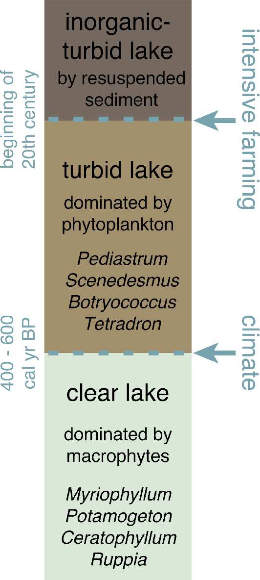
Figure 1: Schematic representation of Holocene changes in trophic states of shallow lakes from the Pampa plain in Argentina (Stutz et al. 2012). Arrows indicate ecological thresholds, points at which there are abrupt changes in the aquatic system, and the drivers identified. |
The course focused on state-of-the-art methodological approaches and techniques applied to diverse paleoresearch issues in chronology and proxy development. The event was organized into different activities: lectures, practical classes, poster presentations, a field trip, and the development of a joint research project. These activities addressed the interaction of different external (e.g. climate variations, human activities) and internal forcing factors (e.g. population dynamics, dispersal, resilience) responsible for ecosystem changes. They also looked at the spatial and evolutionary responses of organisms to long-term climatic changes.
Participants designed a multi-disciplinary research project based on the analyses of sediment cores recovered in shallow lakes of the Pampa region. The cores were described and sub-sampled for different analyses during the course, and the analysis of the samples is now taking place at the participants’ home institutions. Findings from this research will be communicated to all other participants. In this way, we are building a network of young scientists in Latin America: Synergy Latina. The main goal of this particular project is to contribute to the understanding of the regional changes in climate and the environment during the Holocene. Paleoenvironmental reconstructions from the Pampa region are important for understanding this large ecosystem, which has been completely converted into agricultural land, apart from the costal dunes (Fontana 2005). In addition, sediment records from this region also offer the opportunity to look at changes in trophic states of lakes through time (Stutz et al. 2012), applying the ecological theory of alternative stable states of the aquatic systems on long time scales (Scheffer et al. 1993, 2001; Fig. 1). The outcome of this project will contribute significantly to understanding the drivers of pampean lake dynamics on a long-term perspective.
The workshop also aimed to promote social and scientific exchange between research groups from different Latin American countries, while enhancing the skills and knowledge of all of the participants through field, laboratory, and computer exercises. Because the number of applicants far exceeded the available workshop slots, the organizing committee is now considering offering this course on an annual basis.
In addition to the financial support from PAGES, participants obtained support from their home institutions, universities and research councils. A personal grant from the Ministry of Science and Technology of Argentina, Milstein-raíces program, to SLF helped develop the workshop. The 14CHRONO Centre at Queen’s University Belfast, UK, supported the Synergy Latina project by providing radiocarbon dating of the sediment records. We would like to thank Silvina Stutz, Alejandra Marcos and Marcos Echeverria for coordinating the different activities during the meeting. The full program of activities, including abstract presentations can be viewed at: www.uni-goettingen.de/en/413062.html
affiliations
1Department of Palynology and Climate Dynamics, University of Göttingen, Germany
2School of Geography, Archaeology & Palaeoecology, Queen's University Belfast, UK
contact
Sonia Fontana: Sonia.Fontanabiologie.uni-goettingen.de
references
Fontana SL (2005) J Paleolimnol 34: 445-469
Scheffer M et al. (1993) Trends Ecol Evol 8: 275-279
Anne Hormes1, J. Werner2, K. Husum3 and N.J. Steiger4
Arctic2k meeting, Vienna, Austria, 13 April 2015
The Arctic2k working group met for an open meeting during the European Geosciences Union (EGU) General Assembly 2015 to discuss the current state of the group and future activities. Twenty-five participants attended the meeting.
Johannes Werner reported on the status of the database and the plans for creating regional temperature reconstructions. As the Arctic2k region already had a well-developed database for the first phase of the temperature reconstructions (see PAGES2k Consortium 2013; McKay and Kaufman 2014), only a few new temperature records have become available since then. The largest “gap” identified in the current temperature database is a number of tree ring records, mainly from Scandinavia and Russia, that have not yet been included. Hans Linderholm is currently quality checking and formatting these records.
 |
|
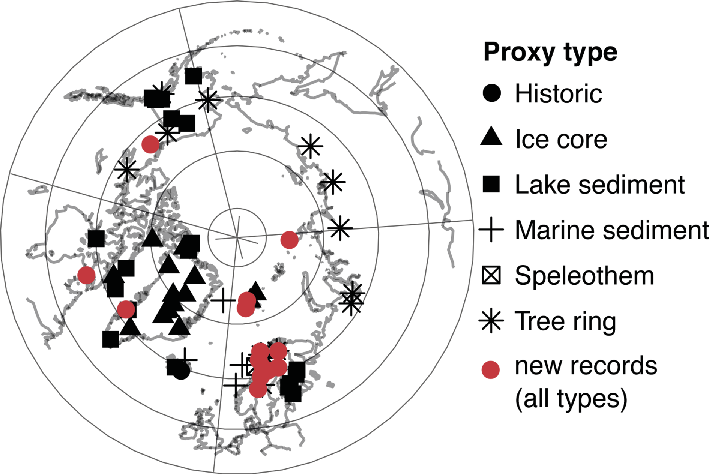
Figure 1: Overview of temperature proxy archives in the Arctic2k database, new records are highlighted in red. |
One problem identified in recent temperature field reconstruction attempts is the poor skill over Greenland (e.g. Anchukaitis and McKay 2014), which is surprising given the relatively good coverage of ice core records. Thus, to find the source of the problem, Valerie Masson-Delmotte has volunteered to coordinate an activity to check the quality and climatic interpretation of the ice core data, and their correlation with the regional meteorological records.
Another project proposed by Jostein Bakke aims to prepare a funding application for additional 210Pb and 14C dating of existing sedimentary climate records. This would serve two purposes: data that could, up until now, not be included in the 2k database could then pass the dating selection criteria, and data already included would be improved.
Hydroclimate
A breakout discussion, lead by Anne Hormes, focused on the hydroclimate and the type of proxy records available. As a first step, the group decided to work on a paper reviewing the available records in the Arctic and discussing which hydroclimate parameters could be reconstructed. The linked proxy record database will be completed by the second half of 2015, to allow enough time to create a hydroclimate reconstruction for the 2k Network synthesis in 2016. Please contact Hans Linderholm or Anne Hormes if you want to contribute to the collection and quality control of the proxy records, or to contribute to the review article.
Reconstruction methods
A second group, lead by Johannes Werner, discussed the spatial temperature and precipitation reconstructions themselves. Although the spatial density of data in the Arctic is low, the group will attempt a circumarctic spatial temperature reconstruction. However, it was noted that great care must be taken in communicating the reconstruction quality and uncertainties that would change through time and space. A promising method for doing this was recently showcased by the NOAA 20th Century Reanalysis Project, and consists of clouding out areas that do not fulfil the criteria for trustworthy reconstructions. Johannes Werner and Nathan Steiger offered to lead the reconstruction effort, using Data Assimilation and Bayesian hierarchical models. Contributions from other reconstruction groups are encouraged.
Climatically coherent regions that are well covered in terms of proxy data will also be identified. Generating regionally averaged reconstructions over these regions will provide a valuable second set of reconstructions that can be compared with the spatial reconstructions.
The group agreed that a reconstruction should be more than an updated version of already available spatio-temporal climate reconstructions. One novel aspect could be improving the communication and visualisation of the spatio-temporal uncertainties of the reconstruction. Additionally, a fortuitous fact is that the landmasses surrounding the North Atlantic basin are relatively well covered in terms of proxy records, and preliminary results show that good reconstruction skill over this region is possible. A North Atlantic reconstruction should enable the comparison of atmospheric circulation changes that can then be linked to high-resolution marine archives. Several decadal resolution sediment archives are available, and new sclerochronological records will hopefully become available in time for the final comparison.
affiliations
1Department of Earth Sciences, University of Gothenburg, Sweden
2Department of Earth Science, University of Bergen, Norway
3Norwegian Polar Institute,Tromsø, Norway
4Department of Atmospheric Sciences, University of Washington, Seattle, USA
contact
Anne Hormes: anne.hormesgvc.gu.se
references
Anchukaitis KJ, McKay NP (2014) PAGES Mag 22: 98
McKay NP, Kaufman DS (2014) Sci Data 1, doi:10.1038/sdata.2014.26
PAGES 2k consortium (2013) Nature Geosci 6: 339-346
Takeshi Nakatsuka
4th Asia 2k workshop, Kyoto, Japan, 19-20 March 2015
The Asia 2k working group met at the Research Institute for Humanity and Nature in Kyoto, Japan, to coordinate its phase 2 activities i.e. collecting Asian paleo-records and integrating them into climate, in particular hydroclimate, reconstructions for the past two millennia.
Historical hydroclimate variability, such as severe droughts and floods, has played a key role in people’s welfare in Asia. However, creating the hydroclimate field reconstruction (HFR) needed to better understand this natural variability is a significant challenge due to the heterogeneous nature of precipitation over the Asian monsoon region. Data coverage is still scarce for hydroclimate indicators over Asia, and the statistical models still have a challenge integrating the available multi-proxy records with various temporal resolutions. Thus, new data have to be found to fill the spatial gaps, realistic HFR targets set, and the best methods to achieve these discussed; these points were at the center of the discussions at this meeting.
 |
|
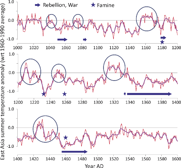
Figure 1: The Asia 2k East Asia summer temperature record (Cook et al. 2013) has enabled the detailed comparison of climate and Japanese history over the last millennium and has stimulated an interdisciplinary research project between paleoclimatologists and historians on societal adaptation to climate change (http://www.chikyu.ac.jp/rihn_e/project/H-05.html). Major medieval famines and warfare often occurred at times of sudden cooling after multi-decadal warmth. |
Almost 40 researchers, including 10 graduate students and postdoctoral fellows, participated in the workshop. Many Asian and non-Asian countries were represented: Japan, China, Russia, India, Pakistan, Nepal, Sri Lanka, Germany, USA, New Zealand, and Switzerland. After an opening remark on the application of Asia 2k’s phase 1 results (Cook et al. 2013) in an inter-disciplinary research project (Fig. 1), the first day of the meeting was dedicated to participants’ reports on their expertise and research related to Asia2k. On the second day, discussions focused on the goals and timeline of the working group, the status of the data collection, and devising the integration strategies required to achieve the climate field reconstructions.
Although creating spatial hydroclimate reconstructions is a challenge in the monsoon region, the region has also many advantages, especially thanks to the various types of proxy records available. For example, tree ring chronologies in Asia have great potential to reconstruct past hydroclimate. Many new tree-ring oxygen isotope chronologies were recently published; these can record past changes in regional summer precipitation and relative humidity (e.g. Xu et al. 2013).
In Asia there are also several stalagmite, coral, sediment, and ice core series recording various aspects of the hydroclimate. Together with the tree ring data, all of these proxies can serve as a strong basis for the creation of hydroclimate records. Chinese documentary records on flood and drought covering more than two millennia are also very promising proxies, as well as those from Japan covering the last millennium. Because hydroclimate reconstructions need more densely distributed proxy data than temperature reconstructions and no millennial-long tree-ring chronologies are available from the more populated areas like eastern China, the inclusion of documentary data is crucial.
In a first step, the group has been working on an updated version of the Monsoon Asia Drought Atlas (MADA; Cook et al. 2010). The new MADA will serve as a benchmark for comparison with planned multi-proxy reconstructions, and its tree ring database is the basis for the new data collection. Currently, the group is collecting hydroclimate records and adding them to the database using the same selection criteria and format as used by the 2k Network for its global temperature database. The goal is to produce a gridded reconstruction of monsoon precipitation using a Bayesian approach. If the data coverage is too sparse for a full spatial reconstruction, index reconstructions of sub-regions will be targeted. Independent data, such as glacier extents will be considered for validation purposes.
In addition to its main focus on hydroclimate, the group has also produced a first version of a multi-proxy spatial temperature reconstruction (Shi et al. 2015). The final version of the temperature reconstruction will be based on several reconstruction methods and integrate high- and low-resolution records.
affiliation
Research Institute of Humanity and Nature, Kyoto, Japan
contact
Takeshi Nakatsuka: nakatsukachikyu.ac.jp
references
Cook ER et al. (2010) Science 328: 486-489
Cook ER et al. (2013) Clim Dyn 41: 2957-2972
Shi F et al. (2015) Clim Change, doi:10.1007/s10584-015-1413-3
Xu C et al (2013) Palaeogeog, Palaeoclimatol, Palaeoecol 386: 588-598
Marie-José Gaillard1, A.-M. Lézine2, K. Morrison3 and LandCover6k Steering Group4
Paris, France, 18-20 February 2015
The goal of PAGES’ new LandCover6k Working Group is to achieve Holocene land-cover and land-use reconstructions that can be used to evaluate and improve the scenarios of anthropogenic land-cover change (ALCC) by Klein Goldewijk et al. (2011; HYDE) and Kaplan et al. (2009; KK) for the purpose of climate modeling studies (Gaillard et al. 2015). LandCover6k focuses on the last 6000 calendar years, i.e. the period in the Holocene when anthropogenic deforestation occurred in most continents, but it will also cover older periods in regions where significant human impact on vegetation occurred earlier. LandCover6k has links to other research programs, in particular IHOPE (Intergrated History and Future of People on Earth), GLP (Global Land Project), PMIP (Palaeoclimate Modelling Intercomparison Project), and PAGES' GPWG (Global Paleofire Working Group).
This workshop was attended by 50 participants from 17 countries. Its purpose was to summarize the state of the art in land cover studies in the Americas, Europe, Africa, Asia, and Oceania, and to discuss the working group’s strategy for achieving its goals. The first part of the workshop was devoted to lectures and discussions on (i) the problems related to current descriptions of past land cover in climate modeling studies, (ii) the ALCC scenarios, (iii) the methods used to reconstruct past land use and land cover, (iv) the status of the pollen databases, and (v) existing land-use and land-cover reconstructions. The second part of the workshop was devoted to organizing the working group, planning the strategy, and creating a timeline for the first three-year phase, including the next workshops and scientific products.
The participants decided that the LandCover6k research activities would be divided into two major areas, Land Cover, coordinated by Marie-José Gaillard, and Land Use, coordinated by Kathleen Morrison. Furthermore, the group is divided into nine subgroups each with one or several coordinators. The nine subgroups are (1) N America, (2) Latin America, (3) Europe, (4) Africa, (5) Asia, Australia, Oceania, (6) Land use (from archeological and historical data), (7) Methodology focused on the tropics, (8) Anthropogenic Land Cover Change (ALCC) modeling (i.e. revision of the ALCC scenarios KK and HYDE), and (9) Pollen productivity estimates (PPE).
 |
|
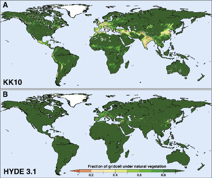
Figure 1: A comparison of human land use estimates (fraction of deforestation) around AD 1 from (A) the KK10 scenario (Kaplan et al. 2009) and (B) HYDE 3.1 (Klein Goldewijk et al. 2010). LandCover6k aims to improve the KK and HYDE scenarios and decrease their discrepancies using land-use reconstructions based on archeological and historical data, and quantitative land-cover reconstructions based on pollen records (forested versus deforested land). |
LandCover6k will first focus on three time windows, 6000 BP, 450 BP, and 100 BP, as an intermediate product to test the methods and strategies. Additional time windows will be added at the end of the first three-year phase. Reconstructions of past land use will be achieved mainly by the community of archeologists and historians, and will include the challenging effort of upscaling archeological and historical information into maps of past major land-use systems. Reconstructions of past land cover at the global spatial scale will be achieved using pollen data and various methods including the modern analogue approach (e.g. Blois et al. 2011), biomization (e.g. Fyfe et al. 2013) and the REVEALS model (e.g. Trondman et al. 2015).
Of the meetings planned at the February workshop, several have already happened, including a working and information meeting at INQUA 2015, Japan; a Land-Use workshop in October 2015 in Paris, France organized by Kathleen Morrison; a steering group meeting in November 2015; and a training workshop on pollen-based reconstructions of land cover in September 2015 in Reading, UK. There will be a Landcover6k sessions at AGU (2015) and EGU (2016). We also plan sessions at the International Congress of Palynology (IPC) in 2016, and at the next PAGES Open Science Meeting (OSM) in 2017, as well as a number of workshops in 2016.
Further details on the organization of the working group, coordinators and key participants, and future activities can be found on the LandCover6k website: pastglobalchanges.org/science/wg/landcover6k/intro.
affiliations
1Biology and Environmental Science, Linnaeus University, Kalmar, Sweden
2LOCEAN, Pierre et Marie Curie University, Paris, France
3Anthropology, University of Chicago, USA
4pastglobalchanges.org/science/wg/landcover6k/people
contact
Marie-José Gaillard: marie-jose.gaillard-lemdahllnu.se
references
Blois JL et al. (2011) Quat Sci Rev 30: 1926-1939
Boyle JF et al. (2011) Holocene 21: 715-722
Fyfe R et al. (2013) Quat Sci Rev 73: 132-148
Gaillard MJ et al. (2015) PAGES Mag 23(1): 38-39
Klein Goldewijk K et al. (2011) Glob Ecol Biogeogr 20: 73-86