PAGES Magazine articles
|
|
Martin Hinz1,2, J. Laabs1,2 and M.E. Castiello1
Bern, Switzerland, 4-6 February 2019
Quantitative methods are transforming how archaeology approaches the investigation of the human past. The emerging possibilities of data integration and computational modeling enable interdisciplinary research on a new level. In large part due to the current challenges imposed by climate change, there is a growing awareness of the importance of past environmental conditions on human history. Archaeology possesses an unmatched record of societal responses to such changes, which can only be utilized by integrated research and quantitative analysis.
In order to facilitate the exchange of knowledge from recent research in this field, the Institute of Archaeological Sciences and the Oeschger Centre for Climate Change Research at the University of Bern, Switzerland, organized the first International Colloquium on Digital Archaeology in Bern. For two days, 60 participants from different disciplines, many of whom were young academics, exchanged information on the status and potential of digital archaeology and socioecological modeling as an integral part of responsible and relevant research approaches. The diverse and valuable contributions were complemented by the keynote speakers’ inspiring talks.
Oliver Nakoinz (University of Kiel, Germany) started by situating digital and quantitative archaeology both thematically and historically. He pointed out that only integrative research that realistically reflects both societal and environmental influences on human development enables us to make meaningful statements about the past. The main part of the lecture therefore established quantitative archaeology not only as an integral part of archaeology itself, but rather as a natural link between the scientific approach aimed at structural analysis and the traditional approach of the humanities aimed at negotiating historical meaning and developing narratives.
Many of the following contributions dealt with quantitative approaches in spatial and non-spatial archaeological case studies as well as data-mining and new techniques of supervised and unsupervised pattern recognition in archaeological and ecological data. Juan Barceló's (Universitat Autònoma de Barcelona, Spain) keynote closed the first day and opened a rich final discussion with his pointed and provocative lecture. He reflected on the challenges and opportunities of big data and machine learning for a subject like archaeology and made his position clear that scientific archaeology can only be quantitative. This did not go unchallenged, and an active debate arose, which only ended because of the conference program’s time restraints.
 |
|
Figure 1: Processes studied and presentations from this workshop situated on a triangular diagram of past environment, society, and technology. |
The following day was opened by Mikhail Kanevski (University of Lausanne, Switzerland), who, from the perspective of computer science, showed the unexplored potential of artificial intelligence. He spoke about machine learning in the field of geospatial data and demonstrated that this tool is one of the most promising for the investigation of complex environmental phenomena. Especially when considering the multilayered human influence, it is of utmost importance to separate effective factors from noise for specific research questions. His contribution was an enormous enrichment for the methodological scope of the colloquium.
The conference ended with a lecture from Michael Barton (Arizona State University, USA). He stated that the time of purely reconstructive archaeology is over, because reconstructing the past has turned out to be impossible. Rather, it is necessary to use the long-term perspective and the far-reaching data of archaeology for questions regarding the interaction between humans and the environment and to enable robust testing of assumptions about human dependency and decision making with regard to environmental change through explicit, quantitative and computer-supported models. This can position the discipline as an important driver in current discussions.
The colloquium and the discussions showed that archaeology is on the brink of fundamental changes in handling and analyzing big data and complex systems. This will not only impact the discipline itself but will influence the interdisciplinary work in which archaeology is involved. Digital and quantitative archaeology is an important interface between the natural sciences and the humanities for the investigation of long-term human-environment interactions in the past and their added value for today’s discourses. This perspective is already advocated by the PAGES LandCover6k and PEOPLE 3000 working groups.
We, therefore, were happy that PAGES endorsed the colloquium and offered us the opportunity to demonstrate why conferences and workshops connected to digitization and quantitative approaches in the field of archaeology are important for the future collaboration between (paleo-)environmental/climate and (pre-)historic sciences.
The colloquium’s abstract booklet can be accessed at: doi.org/10.5281/zenodo.2628304
affiliationS
1Institute of Archaeological Sciences, University of Bern, Switzerland
2Oeschger Center for Climate Change Research, University of Bern, Switzerland
contact
Martin Hinz: martin.hinz iaw.unibe.ch
 |
Rachid Cheddadi1, N. Mhammdi2 and F. Sarmiento3
Rabat, Morocco, 1-5 October 2018
Cuenca, Ecuador, 10-15 March 2019
Two recent PAGES-endorsed conferences on "Past plant diversity changes and mountain tree species conservation" provided a great opportunity for scientists from different disciplines to discuss the issue of how the knowledge of plant diversity and ecosystem responses to past climate changes may help in managing species’ persistence under ongoing global climate change. They were held under the umbrella of the ongoing project VULnerability of Populations under Extreme Scenarios (VULPES, vulpesproject.com, 2016-2020). The choice of locations was driven by the fact that both Morocco and Ecuador are hotspots of biodiversity with impressive numbers of endemic species, many of which are threatened with extinction. Both conferences were sponsored and introduced by the local authorities, which stated loudly and clearly the importance of organizing such meetings in their countries, where biodiversity is a national cause. In Ecuador, the protection of wildlife is now included in the constitution, and plants are protected by law.
Scholars have clearly shown that under current global climate change, many plant species should either adapt locally to persist in situ or migrate, if at all possible; otherwise, their modern range will be impacted to the extent of potential extinction. The geographical distribution of many mountain tree species is becoming more fragmented, often with a trend toward a reduction of the established areas. These tree species are considered by the IUCN Red List (iucnredlist.org) as endangered or threatened with extinction. The VULPES project focuses on a small number of these vulnerable mountain tree species (case studies) in Africa, China, and South America using a multi-disciplinary, multi-scale, and multi-species approach. Sessions at the two conferences were designed to fit this approach and to allow for, on the one hand, presentations of project results by the partners to a wider community, and, on the other hand, input by members of this wider community through the presentation of their own results and open discussion.
In Rabat (vulpesproject.wixsite.com/biodiv2018), there were five sessions, each of which was introduced by an invited keynote speaker. Here we examined the relationship between past environmental changes and their impacts on plant species’ diversity. The five sessions dealt with climate models and past climate variability (keynote Michel Crucifix, University of Louvain, Belgium), the species refugia during climatically unsuitable time periods (keynote Keith Bennett, University of St Andrews, UK), species migration and impacts on their genetic diversity (keynote Arndt Hampe, University of Bordeaux, France), modeling the species range (keynote Signe Normand, Aarhus University, Denmark) and, finally, the lessons we can draw from the past to help conserve plant species (keynote Steve Jackson, University of Arizona, USA). The conference was small (about 50 attendees) with brilliant presentations, which led to very interesting and in-depth discussions. In addition to the scientific attendees, Moroccan stakeholders were also present and clearly showed their interest in being involved in the process. The head of the Scientific Institute of Rabat, Dr. M. Fekhaoui, organized a tour of the local museum where hundreds of endemic plant and animal species from Morocco have been inventoried. The conference was followed by a two-day excursion to one of the largest and best preserved Atlas cedar forests, in the Ifrane National Park. The Atlas cedar is an endemic species to North Africa and considered to be endangered by the IUCN Red List. Twenty-five participants joined the excursion, which allowed for additional interesting discussions on many topics related to species conservation.
In Cuenca (vulpes-ecuador2019.com), in order to increase the discussion time among the 70 attendees, there was one “opening” and one “closing” keynote each day. The first day was introduced by Paul Valdes (University of Bristol, UK) on modeling past climates and the contribution of models to comprehending the mountain climate system. The closing keynote was David Neill (Universidad Estatal Amazónica, Puyo, Ecuador) with an open discussion on the endemic plant species from the sandstone summits (Andean tepuis) of the Cordillera del Cóndor in Peru and Ecuador. The second day was dedicated to plants’ genetic diversity and long-term refugia. The introductory keynote was given by Mark Bush (Florida Institute of Technology, USA) on the microrefugia concept and how they may contribute to the future persistence of species in situ. Pierre Taberlet (University of Grenoble, France) provided the closing keynote on genetics and conservation biology within the context of Quaternary refugia. During the third day, three excellent choices of excursions were organized: (1) Ingapinca Inca archaeological site; (2) El Cajas National Park into the páramo, glacial lakes, and Andean (Polylepis) forests; and 3) El Collay community-protected forests and socioecological production landscape in the Azuay highlands. The last day of the conference was dedicated to practical scenarios for mountain forest conservation, with an introductory keynote by Veerle Vanacker (University of Louvain, Belgium) on landscape dynamics in tropical Andean ecosystems in response to natural and anthropogenic disturbances. Selene Báez (National Polytechnic School, Quito, Ecuador; Fig. 1) provided the last keynote of the conference on the effects of current global environmental change on Neotropical montane forests. This conference was marked by the participation of a large number of university students from Quito, Loja, and Cuenca, who took part actively through very interesting posters.
 |
|
Figure 1: Selene Báez discusses the effects of current global environmental change on Neotropical montane forests (Cuenca 10-14 March, 2019). Photo credit: Elena Sarmiento |
The discussions that took place at both conferences highlighted several interesting points: firstly, the size of the meeting (between 50 and 70 participants) was key to enabling extended presentations as well as in-depth discussions. Secondly, the multi-disciplinary sessions with a joint focus on how we may contribute to better conservation of the biodiversity were highly appreciated by all participants, stakeholders, and students. These two conferences were concrete opportunities to exchange new ideas and learn new approaches, techniques, and concepts. One of the main conclusions is that the problem of preserving biodiversity cannot be tackled by one single discipline, concept, or approach. We need to combine our knowledge and work together through not only multi-disciplinary projects but also small multi-disciplinary meetings, where enough time is dedicated to in-depth discussions and direct exchanges with stakeholders and students.
affiliationS
1University of Montpellier, France
2University Mohammed V of Rabat, Morocco
3University of Georgia, Athens, USA
contact
Rachid Cheddadi: cheddadi.rcgmail.com
Kazuyo Tachikawa1, R. Anderson2, L. Vidal1 and C. Jeandel3
GEOTRACES-PAGES joint workshop, Aix-Marseille, France, 3-5 December 2018
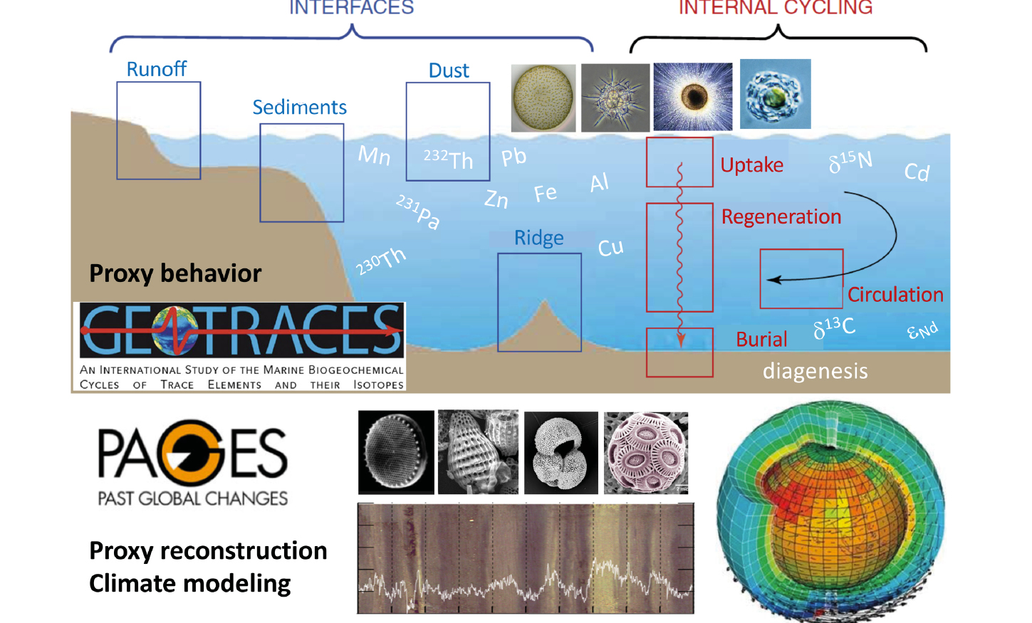
Reconstruction of past ocean states relies on the use of “proxies” (indicators or tracers), since it is impossible to directly measure variables such as water temperature, biological production and ocean circulation. In order to clarify the ocean’s response to natural and anthropogenic forcings, it is essential to improve our knowledge of proxy behavior and the associated uncertainty. This task will be most efficiently achieved by the synergy between marine geochemists and paleoceanographers, as well as proxy and climate modelers. The first joint workshop of GEOTRACES-PAGES (geotracespages.sciencesconf.org) was such an occasion to identify open questions and scientific gaps of proxies used in paleoceanography. We focused mainly on trace elements and their isotopes (Fig. 1) that are targets of the GEOTRACES program (geotraces.org). These proxies are preserved in biogenic phases and/or bulk sediments and can be used to compare with simulated distribution to quantify physical and biogeochemical processes (Fig. 1). Sixty-four researchers and students from 11 countries from four continents gathered for this objective. The workshop consisted of a series of keynote talks and discussions around working groups with the following subjects: biological productivity, oceanic circulation, particle flux and sedimentation rate, and physical and/or biogeochemical modeling.
 |
|
Figure 1: A schematic diagram presenting possible areas of interaction between the GEOTRACES and PAGES communities: targeted geochemical proxies, factors affecting their distribution, and paleoceanographic approaches associated with the proxies. |
The keynote talks pointed out some recent findings, including the importance of recycled iron for biological productivity on seasonal-to-ice-age timescales (Rafter et al. 2017), and complex biomineralization processes of silicifiers and their impact on the silicon isotopic ratio (Hendry et al. 2018). Multi-tracer analysis of the same water sample is one of the strongest strategies of the GEOTRACES program, and multi-proxy reconstruction provides the most reliable results. However, different proxies sometimes tell us distinct stories. Since each proxy has its own advantage and potential bias, decoupling them can provide additional information. One of the most interesting examples of this decoupling is deep water circulation in the Atlantic Ocean during the last glacial maximum (LGM, 23-18 kyr BP). Three of the most frequently used geochemical proxies in paleoceanography do not tell a single, simple story: benthic foraminiferal carbon isotopic ratios (13C/12C or δ13C) suggest weaker and shallower glacial North Atlantic deep water circulation with a dominant contribution of the southern source water (Lynch-Stieglitz et al. 2007), whereas the neodymium isotopic composition (143Nd/144Nd or εNd) recorded in authigenic oxides of planktonic foraminiferal calcites indicates a significant proportion of northern component waters in the North Atlantic over the LGM (Howe et al. 2016). The particle-reactive radionuclide ratio 231Pa/230Th suggests persistent southward transport of 231Pa during the LGM (Bradtmiller et al. 2014). Reconciliation of these proxy reconstructions will be achieved by improved spatial coverage of tracer data in the modern ocean and proxy-enabled model experiments (Menviel et al. 2017; Muglia et al. 2018) with well-constrained parameters (e.g. particle concentration and partition coefficients according to the chemical composition of the particle), which can be obtained by process studies of the modern ocean, for example, from GEOTRACES.
The workshop identified the necessity to reinforce the study of the water-sediment interface and early diagenetic processes. Benthic fluxes from the water-sediment interface may affect proxy distribution in the water column, and early diagenesis could modify the signature acquired in the upper-water column. More systematic and coordinated sampling of surface sediments and pore waters with samples collected in the overlying water column would help to scrutinize proxy behavior across this interface and promote core-top calibration.
The workshop was a great occasion to trigger coordinated actions that will be further developed in coming years. We identified products such as a compilation database of core-top samples suitable for proxy development and calibration, sensitivity tests and model-data comparisons, a synthesis paper on trace elements and isotope proxies used in paleoceanography and particle flux, intercalibration of methods used to analyze core-top sediments, and an outreach piece on paleo productivity.
affiliations
1Aix Marseille Univ, CNRS, IRD, INRA, Coll France, CEREGE, Aix-en-Provence, France
2Lamont-Doherty Earth Observatory, Columbia University, Palisades, NY, USA
3LEGOS (Université de Toulouse/CNRS/CNES/IRD/UPS), Observatoire Midi-Pyrénées, Toulouse, France
contact
Kazuyo Tachikawa: kazuyocerege.fr
references
Bradtmiller LI et al. (2014) Nat Commun 5: 5817
Hendry KR et al. (2018) Front Mar Sci 5: 22
Howe JNW et al. (2016) Nat Commun 7: 11765 and related Supplementary Material
Lynch-Stieglitz J et al. (2007) Science 316: 66-69
Menviel L et al. (2017) Paleoceanography 32: 2-17
 |
Ed Brook1 and Victor Brovkin2
AIMES-PAGES joint workshop, Hamburg, Germany, 14-16 November 2018
There is increasing realization and concern that human modification of the Earth system runs the risk of inducing abrupt transitions in climate, ocean circulation, the cryosphere, ecosystems, and society (Turney et al. 2016). Our ability to predict when and where such transitions, so-called “tipping points”, might happen is limited. While abrupt climate change has long been identified in ice-core records (Johnsen et al. 1992) and other archives, skillfully modeling abrupt change has largely been limited to simple models (Valdes 2011). Recently, a multi-model assessment revealed abrupt events in state-of-the-art models, suggesting the possibility of predicting the likelihood of such events (Drijfhout et al. 2015).
Advancing our understanding of the full range of possible abrupt climate, environmental, and societal changes through the continued assessment and collection of paleo data and improved multi-model experiments will help us to assess future risks. However, how to best use the paleo records in this regard is not well established. The AIMES-PAGES workshop on abrupt changes, thresholds, and tipping points in the Earth system was organized around this question. Both PAGES and AIMES (Analysis, Integration and Modelling of the Earth System; aimesproject.org) are Future Earth Global Research Projects. Within PAGES, the topic of “Thresholds, tipping points and multiple equilibria in the Earth system” is an established integrative activity. Within AIMES, the assessment of tipping points is identified as one of the four major AIMES projects. The workshop was an outgrowth of a splinter group meeting at the 2018 EGU General Assembly, organized by PAGES, that explored community interest in this topic.
 |
|
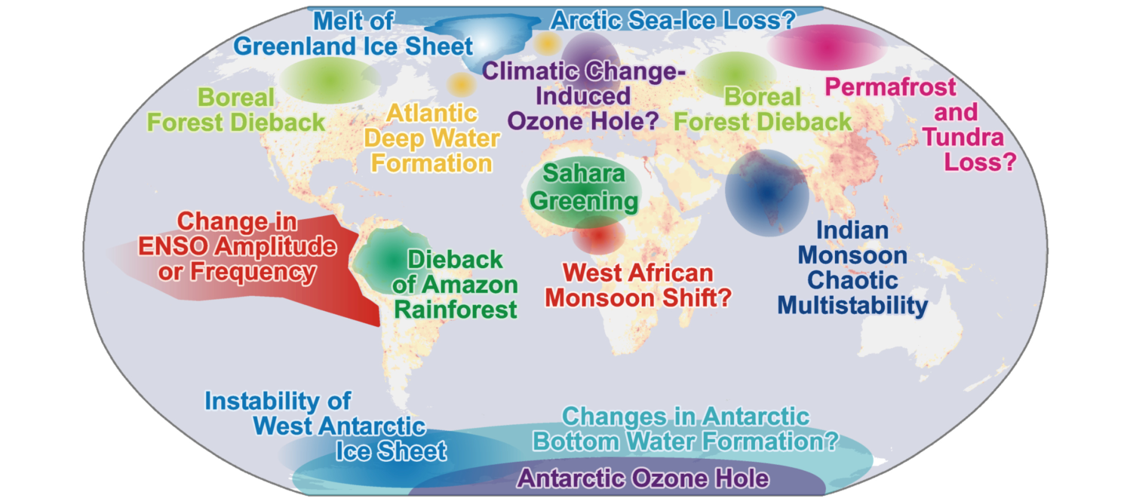
Figure 1: Climate system elements that may be susceptible to tipping point behavior, with background shading showing population density. Modified from Lenton et al. (2008); copyright 2008 National Academy of Sciences. |
Workshop attendees were drawn from a diversity of subdisciplines in paleoenviromental modeling, data collection, and social-environmental systems. Following a series of introductory talks from the perspective of different components of the Earth system (terrestrial and marine environments, the cryosphere, the atmosphere, and human-social systems), breakout groups spent a full day in focused discussion organized around the physical climate system, ecosystems, biogeochemical cycles, and social systems. The primary task of the groups was to evaluate the potential for significant progress in using paleoclimate data to predict future tipping points and abrupt change.
All of the breakout groups reported that significant work is needed to fully take advantage of the paleo record for evaluating the potential for crossing critical thresholds in the near future. Topics emphasized include cryospheric change and its cascading impacts (including sea-level change and permafrost thaw), hydroclimate instabilities (including changes in fire, wetlands, and rainfall), oceanic changes (including hypoxia and rapid changes in ocean circulation), and the interaction of human societies with these changes. Early detection of abrupt transitions is another area of considerable interest that requires further attention.
The groups agreed that it is vital to include the paleo perspective in evaluating future tipping points and related changes, given model uncertainties and the short timescale of direct observations. A synthesis paper describing the future challenges and opportunities in this area is in preparation, and planning for follow-up research and workshops is underway.
affiliations
1Oregon State University, Corvallis, USA
2Max Planck Institute for Meteorology, Hamburg, Germany
contact
Ed Brook: brookegeo.oregonstate.edu
references
Drijfhout S et al. (2015) Proc Natl Acad Sci 112: E5777-E5786
Johnsen SJ et al. (1992) Nature 359: 311-313
Lenton TM et al. (2008) Proc Natl Acad Sci 105: 1786-1793
Caroline Quanbeck1, E. Capron2,3, S. Shackleton4 and J. McFarlin5
PALSEA-QUIGS joint workshop, Galloway, NJ, USA, 24-27 September 2018
The goal of the first joint workshop held by the PALeo constraints on SEA level rise working group (PALSEA, pastglobalchanges.org/science/wg/palsea/intro) and PAGES-PMIP Working Group on Quaternary Interglacials (QUIGS, pastglobalchanges.org/science/wg/quigs/intro) was to identify the state of our understanding on the interplay between climate, polar ice sheets and sea level during past interglacials.
The four-day meeting included three oral sessions with 26 talks, a poster session, an outreach event, a field excursion (Fig. 1), and two discussion sessions.
The first oral session focused on studies of climate, ice sheets, and sea level during the Last Interglacial (LIG). Converging evidence from marine, ice-core and terrestrial records indicate that high-latitude surface ocean temperatures were warmer by at least 1°C relative to pre-industrial and surface air temperatures by >3-11°C (see Fischer et al. 2018 for a recent review). Recent developments in Earth system modeling, in the framework of PMIP4 (Otto-Bliesner et al. 2017), suggest vegetation and sea-ice feedbacks are key to reproducing LIG surface air warmth at the amplitude observed in paleoclimate records. Large uncertainties remain regarding the timing and extent of mass loss from the Greenland and Antarctic ice sheets and their total respective contributions to the higher-than-present global sea level throughout the LIG.
 |
|
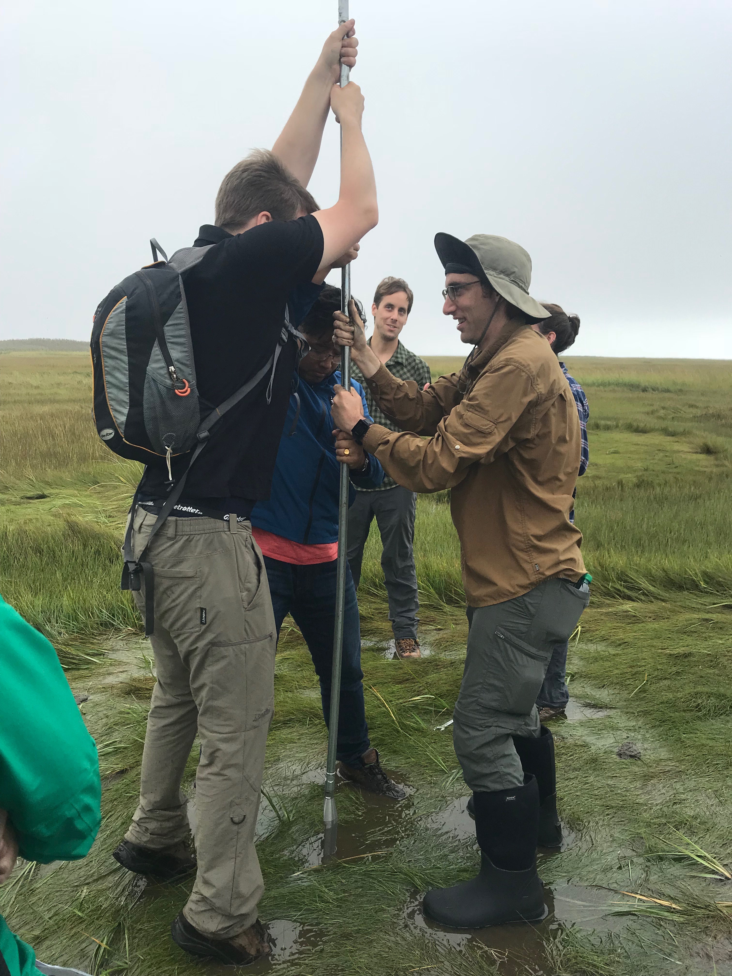
Figure 1: PALSEA-QUIGS scientists coring a salt marsh on the New Jersey coast. Data from salt marshes yield high-resolution records of Holocene sea-level change. Image credit: Robert Kopp. |
The second oral session focused on climate, ice sheets, and sea level during even older interglacials, particularly Marine Isotope Stages (MIS) 11, 13 and 31. Recent work has indicated there are differences in the spatiotemporal expression and amplitude of climatic changes across interglacials. Challenges identified during the workshop include aligning proxy records chronologically, as well as an overall lack of well-dated sea-level benchmarks for these older interglacial periods.
The third oral session centered on Holocene sea level. Compared to earlier interglacials, the Holocene has the advantage that well-dated archives of sea level are available in higher spatiotemporal resolution. This wealth of information allows for better constraints on processes that are also relevant to understanding sea level during older interglacials, such as glacial isostatic adjustment (GIA).
The meeting concluded with discussions dedicated to the identification of the most pressing areas where more research is needed. The key research questions identified include:
• How do interglacial sea-level highstands relate to interglacial temperatures in the high-latitudes, tropics, and globally?
• What determines the size of polar ice sheets in different interglacial climatic contexts?
Discussions primarily focused on the LIG, and emphasized a need for well-dated and highly-resolved climate and sea-level records for this time interval, as well as prior interglacials. Highlighted uncertainties included the rate of sea-level rise at the onset of the LIG, and the net amplitude of LIG global sea-level rise given potential hemispheric phasing of polar-ice-sheet growth and retreat. It was noted that constraining the ice-sheet configuration during the preceding glacial maxima has important implications for interglacial relative sea-level indicators because of the GIA effects.
The group also discussed the importance of using paleoclimate records to better characterize the structure (spatial and temporal) and amplitude of interglacial climate change in order to evaluate Earth system model simulations. This requires better spatial coverage of paleodata, particularly in the Southern and Pacific Oceans. Finally, emphasis was placed on the need to find direct evidence for significant ice-mass loss both in Greenland and in Antarctica, which is crucial to constrain their respective contributions to LIG global sea level.
These key research questions will be summarized in an upcoming opinion paper for the broader paleo sea-level and paleoclimate communities, to encourage future work on the topics. The PALSEA and QUIGS working groups will continue to pursue collaboration through future joint initiatives (e.g. joint sessions at international meetings).
acknowledgements
We thank the supporting organizations: PAGES, Rutgers University, the US National Science Foundation, and the International Union for Quaternary Research.
affiliations
1Department of Geological Sciences, University of Florida, Gainesville, USA
2British Antarctic Survey, Cambridge, UK
3Centre for Ice and Climate, Niels Bohr Institute, University of Copenhagen, Denmark
4Scripps Institution of Oceanography, University of California San Diego, La Jolla, USA
5Department of Earth and Planetary Sciences, Northwestern University, Evanston, IL, USA
contact
Caroline Quanbeck: cquanbeck94ufl.edu
references
Fischer H et al. (2018) Nat Geosci 11: 474-485
Otto-Bliesner B et al. (2017) Geosci Model Dev 10: 3979-4003
Robert L. Barnett1,2, K. Koster3, B. de Boer4,5, A.B.A. Slangen6, X. Benito-Granell7 and E. Alarcón8
Utrecht, The Netherlands, 26-29 August 2018
The iSLR18 conference for early-career researchers (ECRs) was designed to initiate cross-disciplinary engagement for the next generation of sea-level researchers from around the world. The meeting welcomed 68 ECR scientists from 24 different countries to Utrecht, the Netherlands, in August 2018. The range of expertise reflected a broad range of disciplines, which allowed participants to build new partnerships and discuss cross-disciplinary approaches towards addressing some of the key outstanding questions in sea-level science.
The meeting was constructed around four presentation sessions, a full-day excursion to the Holland coastal plain and Rhine River delta, and an evening public engagement event. The four main talks during the public engagement event highlighted the status of current sea-level research of the past, present and future (Fig. 1). The event ended with a lively discussion on possible sustainable solutions for the impact of future sea-level rise on the Dutch coastal delta system. Presentation session topics provided scientific foci for the meeting, which were enhanced through keynote and invited ECR speakers for each.
The session on Past Sea-Level Changes introduced the value of geological and sedimentary archives for developing high-resolution and precise sea-level data for periods preceding instrumental data collection. These geological records are now being used to investigate if Arctic or Antarctic ice sources were responsible for the unprecedented rates of sea-level rise during the 20th century. Moreover, these data are used for exploring the roles of different mechanisms in driving sea-level variability during the Holocene across regional to global scales.
Moving towards Recent and Future Sea-Level Changes, the second session covered a wide range of topics that are important for sea-level change, looking back to the 20th century and ahead to the 23rd century. A thought-provoking talk showed that accounting for glaciers that have disappeared might help to close the 20th century sea-level budget. Other talks focused on important processes that make local sea-level change and variability very different from the global mean – for example, the Indian summer monsoon and coastal erosion in Brazil. The closing talk gave an outlook for the future in considering coastal flood hazard in New York City following the impact of Hurricane Sandy in 2012.
The importance of Mitigation, Adaptation and Coastal Impacts in view of future sea-level changes were addressed in the third session. Several presentations showed that both future sea-level extremes and degradation of coastal zones need to be considered when developing mitigation and adaptation strategies. Most importantly, it is crucial to inform and educate people living near the coast to implement such strategies. The talks revealed that regardless of the global nature of future extreme sea levels, a local focus is essential for mitigating and adapting coastal impacts.
 |
|
Figure 1: iSLR18 organizer Bas de Boer presenting the concept of relative sea-level change to a lay audience on Monday evening's public outreach event. |
Finally, the Submerged Landscapes session showed how Holocene relative sea-level rise drowned past landscapes and affected human settlements. Examples from Africa, Europe, North America, and the Middle East discussed how populated continental shelves were submerged. The presentations could be divided into submerged landscapes offshore covered by seawater, or onshore buried by thick sediment sequences. The session had a strong focus on data retrieval to reconstruct the timing of drowning and rates of relative sea-level rise. Scuba diving in Sweden, deep coring in the Mississippi Delta, and geotechnical and geophysical investigation in the North Sea exemplified this multidisciplinary session.
Following the success of iSLR18, the question raised was: "What’s next"? The synergies created by PAGES and INQUA in Utrecht have set the scene for similar ECR conferences in the future. ECR meetings could fill the years between PAGES and INQUA congresses and could be dedicated to multi-disciplinary research areas that would benefit from synthesizing theories, knowledge, and data. Topics could focus on paleo-informed research for developing the resilience of human-environment systems, in conjunction with the PAGES PALSEA, LandCover6k, PAGES 2k Network, Global Paleofire, EcoRe3 and PEOPLE 3000 working groups and INQUA CMP and PALCOM Commissions.
affiliations
1Coastal Zone Dynamics and Integrated Management Laboratory, University of Quebec at Rimouski, Canada
2Geography, College of Life and Environmental Sciences, University of Exeter, UK
3Geomodelling, TNO-Geological Survey of the Netherlands, Utrecht, the Netherlands
4Insitute for Marine and Atmospheric research Utrecht, Utrecht University, the Netherlands
5now at: Earth and Climate Cluster, Faculty of Science, Vrije Universiteit Amsterdam, the Netherlands
6NIOZ Royal Netherlands Institute for Sea Research, Department of Estuarine and Delta Systems, and Utrecht University, Yerseke, the Netherlands
7National Socio-Environmental Synthesis Center (SESYNC), University of Maryland, Annapolis, USA
8Universidad Central De Venezuela, Caracas, Venezuela
contact
Robert L. Barnett: R.Barnettexeter.ac.uk
Rachael Rhodes1, K. Kohfeld2, H. Bostock3, X. Crosta4, A. Leventer5, K. Meissner6 and O. Esper7
1st C-SIDE workshop, Vancouver, Canada, 24-26 October 2018
C-SIDE (pastglobalchanges.org/c-side) aims to reconstruct changes in Antarctic sea-ice extent in the Southern Ocean over the past 130,000 years and to understand the impact of sea ice on processes such as productivity, nutrient cycling, ocean circulation, carbon cycle, and air-sea gas exchange.
At this inaugural workshop, 32 participants (including three who joined remotely) from 11 countries brought together a broad spectrum of complementary expertise from proxy-based sea-ice reconstructions to Earth system modeling. The two-day program (pastglobalchanges.org/calendar/26812) featured presentations, speed talks, break-out groups and plenary discussions. A particular highlight was a well-attended evening public presentation at the SFU Harbour Centre followed by a public Q&A session.
Workshop participants presented the current understanding of paleo proxies used to reconstruct Antarctic sea-ice conditions, including fossil diatom assemblages, highly-branched isoprenoid biomarkers, and ice-core chemical constituents. All these proxies have great potential as indicators of past sea-ice changes but each has its limitations. Participants considered how various proxy information could be combined to provide complementary evidence of sea-ice changes and described ongoing needs for ground-truthing, culture experiments and process-based modeling to improve our understanding of what each proxy represents.
Presentations on past Antarctic sea-ice changes demonstrated a need for improved temporal resolution and spatial coverage of sea-ice records. However, participants also identified a substantial amount of exciting, ongoing work that will partly help fill these data gaps. One critical target is the ability to reconstruct summer sea-ice extent and to constrain the seasonal cycle of sea ice because it directly impacts deep-water formation, primary production, and air-sea gas exchange. Workshop participants suggested that ongoing and published work be integrated to develop a series of Southern Ocean transects that cross oceanographic fronts and include both ice and sediment cores.
 |
|
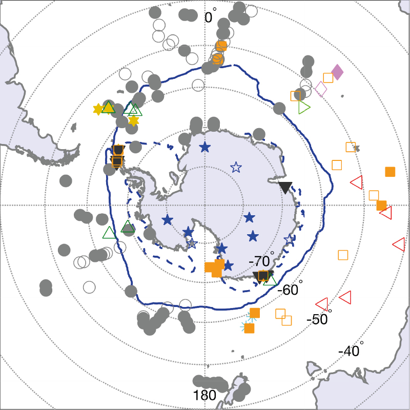
Figure 1: Locations of 160 sites identified by C-SIDE workshop participants with published (closed) and unpublished (open) proxy data that can be used for reconstructing sea-ice characteristics over the past 130,000 years. Sites are identified by H. Bostock & K. Kohfeld (cyan asterisks), M. Chadwick (dark green triangles), O. Esper (grey circles), P. Ghadi (green sideways triangle); J. Mueller (gold stars), A. Nair & X. Crosta (pink diamonds), M. Patterson & A. Leventer (red sideways triangles), X. Crosta (orange squares), X. Crosta & J. Mueller (black inverted triangles), and R. Rhodes (blue stars). Dark blue solid and dashed lines represent the 1981-2010 median sea-ice extent in September and February, respectively (taken from National Snow and Ice Data Center, nsidc.org/data/seaice_index/archives/) |
Complementary presentations described improvements in model representation of present-day sea ice and the difficulty in capturing spatial heterogeneity of sea-ice extent around Antarctica. At the same time, Earth system model transient simulations can provide a dynamic framework for identifying how physical circulation (e.g. Southern Hemisphere westerly winds and deep-water formation) as well as biogeochemical processes (e.g. nutrient and carbon cycling) both in and beyond the Southern Ocean are linked to Antarctic sea-ice changes.
The last full glacial-interglacial cycle is a key interval of focus because: (a) it offers the chance to explore how Antarctic sea ice responded during periods of warmer temperatures than today; and (b) it includes major climate transitions from both warm-to-cold and cold-to-warm climate states, which may shed light on the pace of sea-ice/climate responses, as well as on the potential reversibility of these responses.
Researchers involved in developing proxies agreed upon a framework with which to share and consolidate available datasets that will ultimately be used to produce consistent reconstructions. Likewise, modelers decided how to synthesize sea-ice and sea-surface temperature simulations from the paleoclimate modeling projects PMIP3 and PMIP4 (when these become available in 2019). Collating complementary datasets that can be used to quantify the interaction of sea ice with the wider climate system was recognized as an important objective. A presentation and Q&A session with developers of the Linked Paleo Data (lipd.net) facility sparked interest and discussion around issues of data sharing.
A primary objective of the workshop is to produce a review paper that synthesizes the current knowledge of past Antarctic sea-ice changes and their impact on the climate system. The next C-SIDE workshop is planned for 29-31 August 2019, just prior to the International Conference on Paleoceanography in Sydney, Australia. It will focus on synthesizing and reconciling the various sea-ice proxies and model simulations across the entire glacial cycle. We thank PAGES and Simon Fraser University, Canada, for financial support.
affiliations
1Department of Earth Sciences, University of Cambridge, UK, now at: Department of Geography & Environmental Sciences, Northumbria University, Newcastle upon Tyne, UK
2School of Resource and Environmental Management, Simon Fraser University, Burnaby, Canada
3National Institute of Water and Atmospheric Research, Wellington, New Zealand
4Oceanic and Continental Environments and Paleoenvironments, University of Bordeaux, France
5Department of Geology, Colgate University, Hamilton, NY, USA
6Climate Change Research Centre, University of New South Wales, Sydney, Australia
7Alfred-Wegener Institute for Polar and Marine Research, Bremerhaven, Germany
contact
Karen Kohfeld: kohfeldsfu.ca
Elizabeth R. Thomas
Cambridge, UK, 3-4 September 2018
CLIVASH2k is a PAGES 2k Network project investigating Climate Variability in Antarctica and the Southern Hemisphere over the past 2000 years. Founded as part of the third phase of the PAGES 2k Network, it expands upon the efforts of the former regional groups which aimed to spatially reconstruct important state variables for the climate system. The focus of CLIVASH2k is understanding the drivers of climate variability, and incorporating climate reconstructions from Antarctica, the sub-Antarctic and the wider Southern Hemisphere to explore the regional to hemispheric teleconnections and associated modes of variability.
Forty researchers from more than 20 nations attended the two-day workshop hosted at the British Antarctic Survey. The workshop focused on three main scientific questions:
1) What is our current understanding of sea-ice variability?
2) What are the best proxies or regions for capturing changes in westerly winds?
3) How can paleoclimate data inform predictions of future climate change?
1) Sea ice plays a key role in modulating Antarctic climate, and the best archives of past sea ice arise from marine sediments and ice cores. New marine sea-ice proxies, such as highly branched isoprenoid biomarkers and the increased temporal resolution, are providing unprecedented records of sea-ice dynamics over the past 2000 years. Advanced analytical capabilities are also producing new ice-core proxies, such as organic compounds, sea salts and halogen species. The expanding network of marine records and coastal ice cores, including ice cores from the sub-Antarctic islands, is greatly improving our spatial coverage, especially in regions such as the Antarctic Peninsula and coastal Adelie Land. There is now a realistic potential to combine marine and ice-core proxies in these regions to produce multi-proxy reconstructions. However, the spatial coverage in most other regions is still too poor to produce a comprehensive sea-ice reconstruction for the past 2000 years.
 |
|
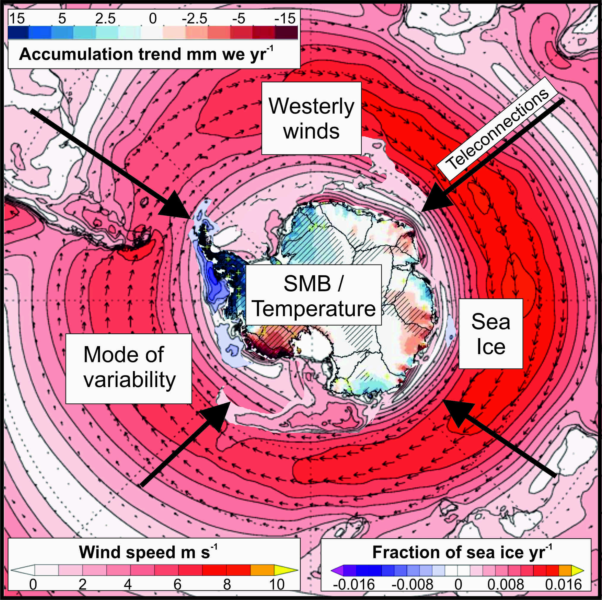
Figure 1: Drivers of climate variability in Antarctica and the Southern Hemisphere. The trend in Antarctic snowfall (Medley and Thomas 2019), the trend in Antarctic sea ice and the zonal wind anomalies from ERA-interim (1979-2010). |
2) Circumpolar westerly winds are a major driver of climate variability. The observed variability in Antarctic surface-mass balance during the 20th century (Fig. 1; Medley and Thomas 2019) is attributed to changes in westerly winds and the Southern Annular Mode (SAM). New paleoclimate reconstructions of the SAM and past westerly wind strength were presented, including Antarctica ice-core and terrestrial records (peat and moss banks), and lake sediments from the sub-Antarctic islands and South America. However, there is little consensus on what each of the proxies is telling us about westerly winds, with apparent differences in the interpretation of increased strength versus a shift in the location of the wind belt. The group agreed that defining the proxies from all archives would be beneficial and that we need to utilize the observational records and climate models to provide clarity in our interpretations.
3) An important aspect of CLIVASH2k is engaging with climate modelers to ensure that paleoclimate data can improve predictions of future climate change. Our workshop, supported by the SCAR scientific research program “Antarctica Climate Change in the 21st Century (AntClim21)” (scar.org/srp/antclim21), brought together climate modelers and paleoclimate specialists. We learned that many climate models struggle to capture the observed changes in key climate parameters, particularly sea ice. Paleoclimate data offers one solution to constrain the models, providing realistic boundary conditions; however, incorporating paleoclimate data is complex and difficult. Advances in data assimilation show promise, but a number of issues remain. The group identified the following recommendations for the paleoclimate community. The modelers require: 1) quantitative rather than qualitative data, 2) gridded data with good spatial coverage, 3) accurate error estimates, 4) a robust description of what the proxies mean, and 5) accurate dating.
The CLIVASH2K working group will hold its next meeting at INQUA in July 2019.
affiliation
British Antarctic Survey, Cambridge, UK
contact
Elizabeth Thomas: lithbas.ac.uk
reference
Benjamin P. Horton1,2,3, R.E. Kopp3,4, A. Dutton5 and T.A. Shaw1
Geological records of sea level have varied in response to a wide range of boundary conditions and climate forcings, and these geological records can serve as a valuable guide to projecting the dynamics of ice-sheet retreat and sea-level rise into the future. However, using geological records in this manner requires a robust understanding of regional variability and rigorous quantification of uncertainty.
Sea-level projections depend upon an accurate understanding of the relationship between climate forcing and the spatio-temporal evolution of sea level, as well as its different driving mechanisms. Yet this understanding is limited by the timescale of the instrumental data; most available records contain data only from the 20th and 21st centuries (Horton et al. 2018). Complementing instrumental data, geological records can provide valuable archives of the sea-level response to past climate variability, including during periods of higher global mean temperatures (Dutton et al. 2015), and can help improve estimates of the relationship between future temperature and sea-level change (Kopp et al. 2016). However, current ties between geological sea-level records and future projections are often vague and tentative; improved interconnections between the two sub-disciplines are thus a key to progress (Horton et al. 2018).
Sea-level-rise projections and geological records of past sea-level change share two fundamental challenges. First, regional sea-level changes vary substantially from global mean sea level (GMSL) change (Khan et al. 2015). Understanding regional variability is critical to both interpreting geological records and generating projections for effective coastal risk management. Second, uncertainty, which is pervasive in reconstructions of geological changes and both physical and statistical modeling approaches used to project future changes, requires careful assessment and quantification.
Here, we highlight two case studies – semi-empirical models of GMSL rise and estimates of the Antarctic contribution to sea level – to illustrate the way in which geological records can improve future projections, and conversely how the need for improved future projections can guide the development of geological sea-level research questions.
Common Era
Semi-empirical models use a statistical relationship between past global mean temperature and past GMSL to estimate the response of future sea levels to projected temperatures. Many semi-empirical models link instrumental records of sea level and temperature with multiple mathematical terms (Vermeer and Rahmstorf 2009). For example, the fast-response term is conceptually linked to heat storage in the ocean mixed layer and the slow-response is conceptually linked to the deep ocean and ice sheets. As of the Fifth Assessment Report of the Intergovernmental Panel on Climate Change (IPCC) in 2013, semi-empirical models were almost universally calibrated only to the instrumental record and yielded projections higher than the bottom-up, process-based projections preferred by the IPCC. For example, Schaeffer et al. (2012) provided a median semi-empirical projection of 21st century GMSL rise under a moderate-emissions pathway (Representative Concentration Pathway (RCP) 4.5) that was 90 cm, compared to the IPCC’s median projection of 53 cm (Church et al. 2013).
The instrumental semi-empirical approach is, however, potentially biased by the short time span of instrumental records, which often post-date the onset of accelerated sea-level rise (Kemp et al. 2011), as well as the presence of substantial decadal and multidecadal sea-level variability that is unrelated to global temperature changes (Horton et al. 2018). One solution to this problem is the use of longer geological records of sea level (Kemp et al. 2011).
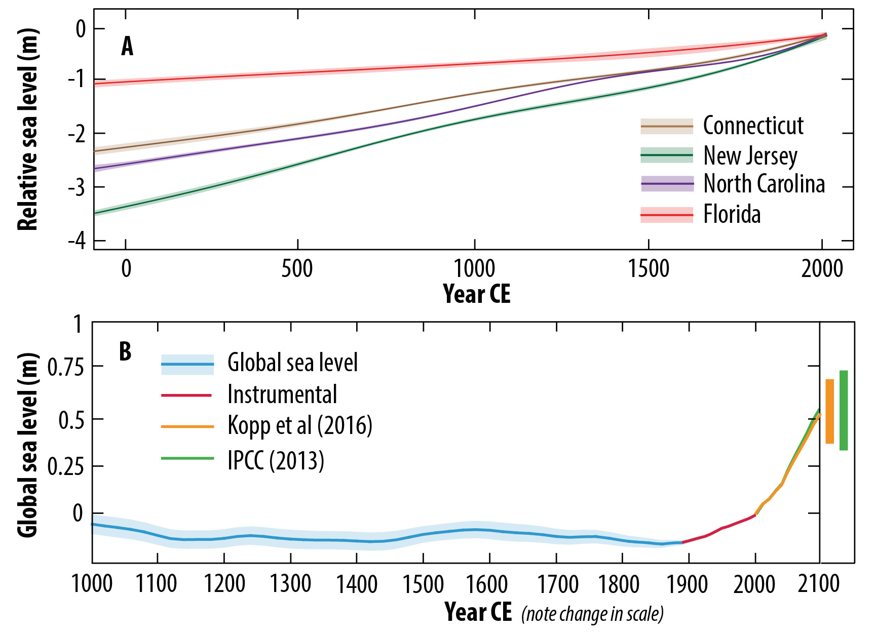
Although temperature and sea-level variability over the Common Era (the last 2000 years) are not analogous to future changes, empirical relationships between high-resolution sea-level records can be paired with temperature reconstructions showing periods of both warming and cooling to examine the dynamic response of sea level to climate forcing on multi-decadal to multi-centennial timescales (Kemp et al. 2011). Common Era proxy records using salt-marsh sediment sequences permit the reconstruction of near-continuous time series of decimeter-scale sea-level changes over this period. Although Glacial Isostatic Adjustment (GIA) is the dominant cause of regional variability (Fig. 1a), it is approximately linear over the Common Era (Engelhart et al. 2009). Simple linear detrending of long-term local trends can thus circumvent uncertainties induced by parameterizations of GIA models, which are needed to correct earlier reconstructions (Dutton et al. 2015). Furthermore, detrending highlights allows for close examination of decadal to centennial variability in GMSL. However, such detrending masked any small changes in GMSL driven by multimillennial-scale processes other than GIA, and prevents an assessment of whether current GMSL is higher than its peak Common Era level.
 |
|
Figure 1: (A) Common Era relative sea-level change on the U.S. Atlantic coast (Kemp et al. 2015 and references therein). (B) Global sea level for the past millennia and 21st century semi-empirical model projections for RCP 4.5 (Kopp et al. 2016). Orange and green bars show the 5th-95th percentile of RCP 4.5 for semi-empirical (Kopp et al. 2016) and process-based (Church et al. 2013) models, respectively. |
Kopp et al. (2016) calibrated a semi-empirical model to a new statistical reconstruction of GMSL and existing global-mean temperature reconstructions. The resulting model indicated that without 20th century global warming, GMSL would have risen by less than 60% of the observed increase from 1900 to 2000 CE and might even have fallen. This estimate is in reasonable agreement with estimates of the human contribution to 20th century sea-level rise based on process models (Slangen et al. 2016). Subsequently, the projections from the semi-empirical model were substantially lower than those calibrated only to instrumental records and, indeed, reconciled the differences between semi-empirical models and the IPCC’s preferred process-based projections. For RCP 4.5, the Kopp et al. (2016) median projection of 21st century GMSL rise was 51 cm, which is essentially indistinguishable from that of the IPCC. Their 66% probability interval of 39-69 cm was in good agreement with the IPCC’s “likely” range, 36-71 cm (Fig. 1b).
While the agreement between semi-empirical projections and the IPCC’s 2013 projections could be viewed as increasing confidence in both, this may be instilling false hope. By construction, the semi-empirical model assumes that the processes driving changes in GMSL over the Common Era are the same as those that will be important in the 21st century, yet the rapid ongoing changes in polar ice sheets suggests that they may not be. Perhaps the agreement is indicating instead that the process models that informed the 2013 IPCC assessment are implicitly exhibiting the same historical biases that are explicit in the semi-empirical model.
Last Interglacial (LIG) and Mid-Pliocene Warm Period (MPWP)
Geological records from the LIG (~128,000-116,000 years ago) and MPWP (~3.2-3.0 million years ago) provide alternative sources of constraints on GMSL change in periods with higher temperatures (Dutton et al. 2015). In particular, these past warm climate intervals can shed light on the dynamics of potential rapid destabilization of sectors of the Antarctic ice sheet that remain poorly constrained in current ice-sheet models. Indeed, after the uncertainty in future greenhouse gas emissions, the possible instability of marine-based sectors of the Antarctic ice sheet is the largest driver of uncertainty in future sea-level-rise projections (Kopp et al. 2017). While no particular past warm interval is a perfect analogue of the present climate forcing, many offer insight into thresholds, time lags between forcing and response, and potential rates of ice-sheet retreat (Dutton et al. 2015).
For the LIG, current estimates of peak GMSL rise indicate that it is extremely likely that it exceeded 6 m (Kopp et al. 2009). Yet while it is generally accepted that sea level during both the LIG and the Pliocene were higher than present, precisely quantifying the magnitude of GMSL rise has proven challenging (Horton et al. 2018). Chronological and vertical uncertainties, and potentially significant contributions from GIA and mantle dynamic topography (Austermann et al. 2017), hinder accurate interpretations of geological data, especially for the Pliocene. Moreover, rates of sea-level change for the LIG and MPWP range from highly uncertain to completely unconstrained depending on the time period (Dutton et al. 2015).
DeConto and Pollard (2016) used both LIG and MPWP constraints to calibrate their continental-scale model of the Antarctic ice sheet. In their model, LIG behavior is correlated with sea-level contributions under low-emissions scenarios in the short term (i.e. until 2100 CE), while MPWP behavior is more indicative of behavior under high-emissions scenarios, especially in the long term (i.e. centuries into the future). However, due in part to the large uncertainties that still exist in LIG and MPWP sea-level reconstructions, there is still ample room for re-interpretation of the geological records, and, consequently, the constraints they provide to future projections of sea-level rise.
These types of exercises, where geological sea-level records are employed to constrain the physical parameterization of the ice-sheet models, help to clarify some important targets for the geological sea-level community. To improve future projections, a key target is to better quantify the magnitude of peak GMSL, which in turn heavily relies upon improving the solid Earth models employed in modeling GIA and dynamic topography. A second key target is establishing both the timing of meltwater input from both Greenland and Antarctica, and constraining the climatic contexts associated with these events.
Ultimately, the fundamental observation from the LIG and MPWP that can be carried over to the present day is that ice sheets (and sea level) have the potential to respond rapidly and non-linearly to warming temperatures. This knowledge should empower us to act now and prepare for a waterier future as global mean temperatures and sea levels continue to rise.
affiliations
1Asian School of the Environment, Nanyang Technological University, Singapore
2Earth Observatory of Singapore, Nanyang Technological University, Singapore
3Institute of Earth, Ocean, and Atmospheric Sciences, Rutgers University, New Brunswick, NJ, USA
4Department of Earth and Planetary Sciences, Rutgers University, Piscataway, NJ, USA
5Department of Geological Sciences, University of Florida, Gainesville, USA
contact
Benjamin P. Horton: bphortonntu.edu.sg
references
Austermann J et al. (2017) Sci Adv 3: e1700457
DeConto RM, Pollard D (2016) Nature 531: 591-597
Dutton A et al. (2015) Science 349: aaa4019
Engelhart SE et al. (2009) Geology 37: 1115-1118
Horton BP et al. (2018) Annu Rev Environ Resour 43: 481-521
Kemp AC et al. (2011) PNAS 108: 11017-11022
Kemp AC et al. (2015) Earth Planet Sci Lett 428: 217-229
Khan NS et al. (2015) Curr Clim Change Rep 1: 247-262
Kopp RE et al. (2009) Nature 462: 863-867
Kopp RE et al. (2016) PNAS 113: E1434-E1441
Kopp RE et al. (2017) ArXiv: 1704.05597
Schaeffer M et al. (2012) Nat Clim Change 2: 867-870
Simon E. Engelhart1, J.E. Pilarczyk2 and A. Rovere3
Past land-falling coastal storms have left geological imprints. Studying them can help gauge the intensity/frequency of extreme storm events beyond the instrumental and historical record and provide insights on the severity of storms under warmer climates.
The potential for increased impacts from coastal storms is among the most concerning aspects related to future climate warming. Increasing impacts from these events can be broadly related to two factors. Firstly, it is expected that as relative sea level (RSL) continues to rise through 2300, significant regions, including major metropolitan areas, will be exposed to inundation without requiring any increase in the strength of storms (e.g. Garner et al. 2017). Secondly, increased intensity and frequency of the most extreme events is possible. Together, these two causative factors indicate that coastal flooding is likely to double by 2050 due to the combined effect of RSL rise and storm surge (Vitousek et al. 2017). The study of land-falling coastal storms under future climate scenarios accelerated in the aftermath of Hurricane Sandy (2012) and has been under the spotlight again after Typhoon Haiyan (2013), Hurricanes Harvey, Irma and Maria (2017), and Hurricanes Florence and Michael and Typhoon Mangkhut (2018).
Our understanding of how storms are related to climate is limited by the short instrumental and historical record. A solution to this is to develop and apply proxies for past storms that can improve our ability to provide insights into future storms under a warmer climate (e.g. linkage between proxy sea surface temperature records and hurricane frequency/intensity). Here we describe the characterization of storms in the paleo record including those from historical, Holocene, Late Pleistocene, and Last Interglacial periods, and identify some of the main questions that still need to be answered.
Historical storms
Recent land-falling storms provide opportunities to characterize the sedimentary and geomorphic signatures of events of known intensity and impact. The deposits left behind by instrumentally recorded events (e.g. Hurricane Irma, Fig. 1a) serve as important modern analogues for interpreting older historical and paleo events for which available information is limited (Brandon et al. 2014). Lessons learned in the wake of Typhoon Haiyan’s unusual bore-like (deep, high-velocity flow and short inundation duration in contrast to the more commonly reported gradual rise and prolonged inundation) storm surge provide important insight into the limitations of distinguishing storm impacts from those associated with tsunamis (Soria et al. 2017), whereas insight gained from studies of sediments deposited by Hurricanes Camille and Katrina showed that similarly intense storms have impacted coastlines of the Gulf of Mexico multiple times over centennial timescales (Bregy et al. 2018).
 |
|
Figure 1: (A) Hurricane Irma (2017) sediments deposited on top of beach sand on the island of Anegada, British Virgin Islands. The deposit represents an important modern analogue for interpreting a series of paleo-storm and tsunami deposits preserved within coastal ponds on the island. (B) Overwash deposits (sands and silts) from historical storms (photograph and X-ray view) recorded within saltmarsh peat at Succotash Marsh, Rhode Island, USA. Cores were taken in close proximity to those in Donnelly et al. (2001). |
Emerging research uses modern and historical storm analogues to validate techniques that can be used to enhance the reconstruction of long-term records that capture the variability in recurrence and intensity of storms over centennial to millennial timescales. Sediment grain size is used to infer the flow depth of water over the coastal barrier during past storms (Woodruff et al. 2008), and foraminifera are being used to determine sediment provenance and distance of transport by storm surges (Kosciuch et al. 2018). In the absence of real-time tide-gauge data, these techniques are the only means to reconstruct the flow depth and inland extent of the storm surges that predate the instrumental record, providing information concerning variability in storm intensity under different climates than today’s.
Late Pleistocene and Holocene storms
Traditionally, the reconstruction of land-falling storms beyond the historical record has focused on the identification of anomalous high-energy sediments within low-energy sedimentary environments such as coastal lakes, sinkholes, and fresh/salt marshes (Fig. 1) or erosive features within salt marshes. These methods have successfully produced centennial- to millennial-scale records of storm impact on coastlines, although there are complications such as barrier height changes over time; the changing sensitivity of coastal sites to inundation as RSL and coastline position changes through time; and the preservation potential of the storm deposited sediments. Some of these concerns can be addressed by more recent work using deep-sea sediment cores that contain storm-triggered turbidites as a potential record (e.g. Toomey et al. 2017). Submerged records, including those from blue holes and the deep sea, have the additional advantage of comprising comparatively long records that can stretch into the late Pleistocene (e.g. Toomey et al. 2017) compared to many of the marsh- and coastal lagoon-based approaches that are typically limited to the late Holocene (last 4000 years; e.g. Donnelly et al. 2001). The impacts of storms have also been studied in high-energy environments using boulder deposits (e.g. Cox et al. 2018), but the reconstruction of long-term records is complicated by difficulties in dating deposits and separating individual events from large-scale boulder fields.
Deeper in the past
Boulder and wave runup deposits are the primary parameters used to reconstruct extreme storms on longer timescales (e.g. during past interglacials) that can be used as process analogues for the warmer world predicted for 2100 and beyond. One such candidate for the study of paleo extreme storms is the Last Interglacial, (LIG, ca. 125 kyr BP). Hansen et al. (2016) used numerical simulations and paleo storm proxy data to propose that a future warmer climate could be characterized by “superstorms” (intensities not measured in historical times). They posit that similar “superstorms” may have happened in the western Atlantic during the LIG thanks to geological evidence reported from The Bahamas (Hearty 1997). This evidence consists of very large boulders deposited during the LIG on the island of Eleuthera (Fig. 2) and LIG chevron ridges/runup deposits reported in The Bahamas and Bermuda. The interpretation of these landforms as being indicative of stronger storms during the LIG remains controversial (Engel et al. 2015). Nevertheless, Hansen et al. (2016) revived the study of geological storm proxies in past warmer climates, which had been neglected since the late 90s. Since the publication of Hansen et al. (2016), several papers (including comments and replies arguing about the interpretation of the geological proxies) were published on LIG “superstorms” (Mylroie 2018 and comments and replies therein). The main conclusion that can be drawn from these papers is that more research is needed on extreme storms at these timescales. New-generation hydrodynamic models can help unravel the energy of different coastal storms and hence their ability to generate particular landforms (see Rovere et al. 2017 for an example on LIG boulders).
 |
|
Figure 2: “Cow and Bull,” two large boulders deposited during the LIG on a steep cliff in the island of Eleuthera, The Bahamas. Researchers are debating whether these boulders were deposited by LIG “superstorms” (Hearty 1997), storms similar to modern ones (Rovere et al. 2017), or tsunamis (see discussion in Engel et al. 2015). Others interpret these landforms as karst remnants (Mylroie 2018). |
Future research directions
Although still underutilized on a global scale, long-term geologic reconstructions of past storms are necessary to capture important information concerning the variability in storm frequency and magnitude – information requested by coastal managers as well as insurance companies. Future research directions include expanding the proxy toolkit to extract crucial information from deposits left by land-falling storms such as high-impact events that have a smaller surge but intense rainfall. Further, there is a need to expand Late Pleistocene and Holocene records beyond the Atlantic and Gulf coasts of North America, identify other LIG storm proxies beyond the frequently cited Western Atlantic boulder records, and reduce the subjectivity in the geological interpretation of the intensity of LIG extreme storms. Information derived from geological evidence can be used to constrain and validate inundation models, enhancing our ability to assess the hazard and associated risk for many of the world’s coastlines.
affiliations
1Department of Geosciences, University of Rhode Island, Kingston, USA
2Department of Earth Sciences, Centre for Natural Hazards Research, Simon Fraser University, Burnaby, Canada
3Leibniz Center for Tropical Marine Research, University of Bremen, Germany
contact
Simon E. Engelhart: engelharturi.edu
references
Brandon CM et al. (2014) Sci Rep 4: 7366
Bregy JC et al. (2018) Mar Geol 396: 26-42
Cox R et al. (2018) Ear-Sci Rev 177: 623–636
Donnelly JP et al. (2001) GSA Bull 113: 714-727
Engel M et al. (2015) Atmos Chem Phys Discuss 15: C6270–C6281
Garner AJ et al. (2017) Proc Natl Acad Sci 114: 201703568
Hansen J et al. (2016) Atmos Chem Phys 16: 3761–3812
Hearty PJ (1997) Quat Res 48: 326–338
Kosciuch TJ et al. (2018) Mar Geol 396: 171-185
Mylroie JE (2018) J Coast Res 34: 1471-1483
Rovere A et al. (2017) Proc Natl Acad Sci 114: 201712433
Soria JLA et al. (2017) Sed Geol 358: 121-138
Toomey MR et al. (2017) Geol 45: 1047-1050