PAGES Magazine articles
Celine Vidal1, M. Toohey2, M. Sigl3, K. Anchukaitis4, F. Ludlow5 and A. LeGrande6
4th VICS workshop, Cambridge, UK, 13-16 April 2019
The Volcanic Impacts on Climate and Society (VICS; pastglobalchanges.org/vics) working group initiated Phase 2 this year. The aim of Phase 2 is to extend the scope of VICS to major eruptions throughout the Holocene and beyond by exploring evidence of volcanic forcing, testing model experiments, and placing an increased emphasis on archaeological evidence of societal impacts and responses to complement the focus on written records from Phase 1. This year, the meeting – the largest to date – gathered 70 delegates with expertise in history, archaeology, dendrochronology, ice cores, climate modeling, tephrochronology, and volcanology (pastglobalchanges.org/calendar/2019/127-pages/1828).
Eruptions of the Common Era
The integration of historical records continues to improve our understanding of the physical processes that occurred during past volcanic eruptions and their links with societal hardships, such as the 1783 Laki (Iceland) or 1257 Samalas (Indonesia) eruptions. The exegesis of historical records can help establish links between severe volcanically induced climate deterioration and major societal stressors such as famines and/or epidemics, which may in some cases promote large-scale societal reorganizations (e.g. Manning et al. 2017). Presenters demonstrated a growing recognition that the repeated occurrence of volcanic climatic "shocks", increasingly clear in paleoclimatic records, now provides historians and archaeologists with an important diagnostic tool to chart the evolution of societal vulnerabilities to sudden environmental change.
Presenters highlighted advances in satellite observations of volcanic aerosol, detection of volcanic signals in ice cores, and the use of idealized and comprehensive aerosol models. While uncertainties in aerosol reconstructions will always be present, current efforts are helping to constrain volcanic forcing estimates. For example, analysis of the isotopic composition of ice-core sulfate can be linked to injection height, which has a large impact on the reconstructed radiative forcing (Burke et al. 2019). Advances in dendrochronological records were presented, including work investigating the sources of differences between hemispheric reconstructions, and work looking at the impact of volcanic eruptions on large-scale temperature gradients and their potential impacts. A perspective from the Southern Hemisphere argued that large eruptions in the instrumental era have consistently led to cold temperatures in South Africa.
 |
|
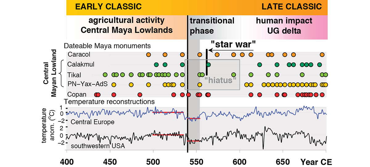
Figure 1: Late Antique Little Ice Age and transformations in the Mayan culture and Northern Hemispheric summer cooling (modified from Nooren et al. 2017 and references therein). Key: PN: Piedras Negras; Yax: Yaxchilan; Ad S: Altar de Sacrificios. |
New evidence was presented on the search for the eruptions responsible for the frequently studied sulfate peaks in ice cores in 536 and 540 CE and major cooling suggested by tree rings in the mid-sixth century, marking the onset of what has been termed the Late Antique Little Ice Age (Büntgen et al. 2016). This cold period coincides with major societal reorganizations in Eurasia and Central America (Fig. 1). Source candidates such as Ilopango volcano (El Salvador) and El Chichón (Mexico) were suggested (Nooren et al. 2017), with new age estimates leading to different conclusions. This highlights the challenge and importance of accurate dating when identifying eruptions and their potential impacts.
Pre-Common Era eruptions
Beyond the Common Era, tree rings show some strong volcanic cooling events throughout the Holocene (e.g. in the fourth and seventh millennia BCE, Nicolussi et al. 2009). Climate modeling suggests that the seventh millennium BCE Mt. Mazama eruption (USA) would have triggered strong cooling in the Northern Hemisphere (Krüger et al. 2018).
Further in the past, archaeological studies are key to understanding the impact of large events, such as the Laacher See eruption (Germany) 13,000 years ago, which had profound effects on the way of life of local contemporaneous Final Paleolithic foragers (Riede 2017). Tephrochronological studies in Eastern Africa are helping to constrain the impact of explosive volcanism on our hominid ancestors in the Pleistocene. In the Ethiopian rift valley, a dozen major eruptions between 360,000 and 100,000 years ago drastically remodeled landscapes and ecosystems, and potentially isolated populations in regions of the rift (Vidal et al. unpublished data).
Outlook
Interdisciplinary groups defined during the second VICS workshop (Zaragoza, Spain, May 2017) are currently working on case studies of eruptions of the Common Era and the first two centuries BCE. It is planned that the outcome of these study groups will take the form of a special issue in Climate of the Past to be published in 2020. Another future focus for VICS will be the investigation of the impact of volcanic halogen on the ozone layer and possible records and proxies of ozone depletion, a process that has recently attracted high interest (e.g. McConnell et al. 2017).
The interdisciplinary nature of research on volcanic impacts is a great strength, but can also pose a challenge for those new to the topic. The VICS community identified the potential value of a "best practices" document, including recommendations for each area of expertise, which would aim to give background on the most important methods, data sets, and assumptions that underpin VICS' research efforts.
Acknowledgements
Thanks to PAGES, QRA, the Department of Geography (Uni. Cambridge) and the Cambridge TephraLab.
affiliationS
1Department of Geography, University of Cambridge, UK
2GEOMAR Helmholtz Centre for Ocean Research, Kiel, Germany
3Climate and Environmental Physics, University of Bern, Switzerland
4School of Geography and Development and Laboratory of Tree-Ring Research, University of Arizona, Tucson, USA
5Trinity Centre for Environmental Humanities, and Department of History, Trinity College Dublin, University of Dublin, Ireland
6NASA Goddard Institute for Space Studies, New York, USA
contact
Celine Vidal: cv325 cam.ac.uk
references
Büntgen U et al. (2016) Nat Geosci 9: 231-236
Burke A et al. (2019) Earth Planet Sci Lett 521: 113-119
Krüger K et al. (2018) EGU Conf Abs 20: 12097
Manning JG et al. (2017) Nat Commun 8: 900
McConnell JR et al. (2017) Proc Natl Acad Sci 114: 10035-10040
Nicolussi K et al. (2009) The Holocene 19(6), 909-920
Nooren K et al. (2017) Geology 45: 175-178
Riede F (2017) Splendid Isolation, Aarhus Universitetsforlag, 214 pp
Stephan Dietrich1, B. Wilhelm2, H. Goosse3 and B.L. Valero-Garcés4
PAGES Extremes Integrative Activity workshop, Koblenz, Germany, 18-20 February 2019
Weather and climate extreme events in a changing climate are able to cause major losses; however, their assessment by scientists remains challenging. As summarized in the IPCC Assessment Report 5 (AR5), this is due to their extreme nature, encompassing weather and climate timescales as well as compound events (such as droughts and tropical cyclones). Thus, both observations and proxy analysis (for paleo timeseries) of extremes are limited.
According to the chapter outlines (wg1.ipcc.ch/AR6/outline.html) of the Working Group I contribution to the AR6 there is a need for enhanced process understanding about, inter alia, the mechanisms, drivers, and feedbacks leading to extremes as well as an assessment of potential surprises including case studies across timescales. In addition, the World Climate Research Programme focuses on the Grand Challenge on Weather and Climate Extremes (wcrp-climate.org/grand-challenges/grand-challenges-overview) from both (i) a service perspective, asking what the frequency and magnitudes of various impact-causing extremes are in the near and long-term future and (ii) a science perspective, looking for causes and mechanisms of variability and change in extremes in order to improve the prediction of change.
The aim of the workshop (pastglobalchanges.org/calendar/2019/127-pages/1827) was to produce a synthesis presenting analyses on long timescales in a way that is suitable for non-specialists. In addition, we aimed to reinforce the coordination between existing research lines on climatological and hydrological extreme events of the past including the instrumental era. Being informed about the accuracy of the available data and the robustness of their interpretation is particularly important for scientists outside of the field. Furthermore, this workshop was designed to provide a platform for scientists working on the more recent period to explain their needs and how their techniques could be applied to longer-term changes.
 |
|
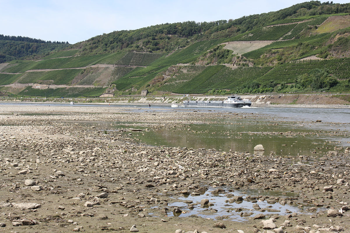
Figure 1: The workshop coincided with the record-breaking 2018 drought, which strongly influenced Central Europe, here in the form of historic lows in water levels. In addition to the strong environmental effects, the continuing drought had an increasing impact on river navigation. This example underlines the importance of extending the observational timeseries into the more distant past. This is necessary for a better understanding of the frequency and size distribution of worst-case extremes and their potential forcing in the area of global change. Photo by Sebastian Kofalk (Federal Institute of Hydrology), 2018, from the village of Osterspai with a view of Bopparder Hamm, Germany. |
To address these issues, we organized a workshop in the scenic town of Koblenz, Germany, as a follow-up to a splinter meeting at the European Geosciences Union General Assembly in Vienna in April 2018. The workshop was organized and co-sponsored by the International Centre for Water Resources and Global Change (a UNESCO Category 2 Water Centre) and hosted by the Federal Institute of Hydrology in Koblenz, Germany. We brought together 20 scientists from eight different countries (including one who joined remotely) with a mixture of early-career and established scientists working in the following fields: global and regional climate modeling, event attribution, proxy reconstruction based on different archives, and statistical techniques. Nearly all scientists had a focus on floods, low flows or droughts. The workshop participants did not expect a synthesis to cover all of these fields, but rather only for what the group defined as hydrological worst-case events (paleo high-magnitude hydro-meteorological hazards).
The workshop consisted of two sections: first, a series of keynotes for setting the scene and oral presentations from participants presenting their work and fields of interest. Second, a series of parallel breakout groups about (i) worst-case (flooding and drought) events, (ii) the physical mechanisms and (iii) requirements of paleo- and observational data. The participants discussed some prominent examples like the Magdalena flood in 1342, which caused significant hazards in Central Europe (see also contemporary example in Fig. 1), or examples where water managers were already using tree-ring data to assess the impact and extent of droughts.
The participants agreed to publish an opinion paper on the occurrence of these extreme events, the underlying climate dynamics, and the impacts on the landscape and humans as a follow-up to the workshop. An additional focus will be on best-practice examples about the data requirements (quality and discoverability of data) and perspectives for the value of paleodata to increase knowledge about current and future extreme events. This opinion paper will give us the opportunity to reach a wide range of users. With this opinion paper, we are particularly interested in targeting users who are not aware of the relevant information provided by paleoscientists and who do not read the specialized literature on this subject. Similarly, new findings from the modern community should also stimulate the discussion within the paleo community.
Find out more about PAGES Extremes Integrative Activity here: http://pastglobalchanges.org/science/int-act/extremes
affiliationS
1International Centre for Water Resources and Global Change, Koblenz, Germany
2Université Grenoble Alpes, CNRS, IRD, Grenoble INP, IGE, France
3Université catholique de Louvain, Belgium
4Spanish National Research Council, Madrid, Spain
contact
Stephan Dietrich: Dietrichbafg.de
Sophie Hüglin1, A. Alterauge2 and A. Hafner2
Bern, Switzerland, 4-7 September 2019
The European Association of Archaeologists (EAA; e-a-a.org/eaa2019) met in Bern to hold its 25th Annual Meeting under the motto "Beyond paradigms" (Criado-Boado and Hüglin 2019). EAA currently has more than 2500 members from more than 50 countries of which more than 1800 took part in this year's conference. The six themes of the conference reached from "Global Change and Archaeology" to "Digital Archaeology, Science and Multidisciplinarity". Each of the themes not only received the attention of several sessions, but was also addressed by a keynote lecture. Due to the high number of sessions (166) and presentations – this year over 1500 – there were more than 30 parallel sessions. Thanks to the local hosts, Albert Hafner and Amelie Alterauge, and to the EAA Secretariat from Prague, the meeting ran exceptionally smoothly.
The theme "Archaeology of Mountainous Landscapes" was specifically connected with Switzerland and the Alps. Linked to this theme, the current president of Swiss Archaeology, Thomas Reitmaier, led a four-day "Grand Tour to the Archaeology of Mountainous Landscapes". Like all other excursions it was expertly organized by ArchaeoConcept and all tours were fully booked. The keynote lecture dedicated to the theme, delivered by Francesco Carrer, was entitled "Aiming High: The rise of mountain archaeology and its role in today’s changing world". Another thematic focus in Bern was archaeoastronomy through the cooperation with SEAC (European Society for Astronomy in Culture), which organized a keynote, three sessions, and a round table. Finally, all keynote presentations and talks from more than 50 sessions will be available online on EAA's YouTube channel.
 |
|
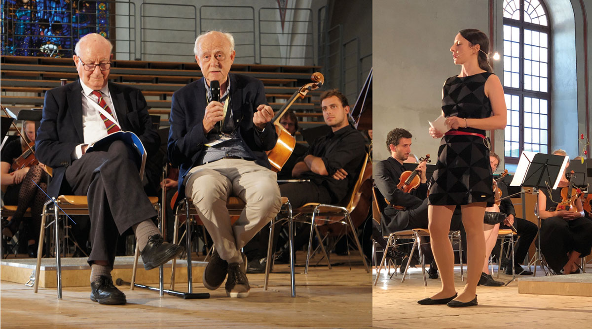
Figure 1: The entertaining opening ceremony in the French Church featured a dialogue between Colin Renfrew (left) and Kristian Kristiansen (middle) on the founding of EAA 25 years ago, and a keynote by Caroline Heitz (right), representing the generation that will shape EAA in the 25 years to come (Photos: Katka Kleinova and Sophie Hüglin). |
Linked to this Annual Meeting, PAGES, represented by its executive director Marie-France Loutre, acted as a co-organizer of the scientific program. PAGES hosted a flyer table in the exhibition tent "Archaeology in Switzerland" where the institutions that supported the local organizers in strategic, financial or practical ways had the opportunity to exhibit their work. In total, six institutions provided information and publications for the public. The exhibition tent was an addition to the European Archaeology Fair (EAF). At more than 25 stands, a range of publishers presented their new publications, and several other organizations and companies demonstrated the latest technologies in archaeological research. PAGES members Ariane Burke and Basil Davis convened session #317 "Celebrating 25 Years of Collaboration: How archaeology and the Earth sciences are coming together to solve real-world problems".
It should be mentioned that the EAA aims to be more than a platform for academic research and networking, but also wants to encourage archaeologists to engage in society and take social responsibility. Therefore, at each meeting an EAA Task Force works on a formal statement that addresses pressing issues. In 2019, at the Annual Members Business Meeting, the EAA adopted the "Bern Statement: Archaeology and the Future of Democracy" (e-a-a.org/BernStatement). The statement emphasizes that: "Archaeologists within EAA will not accept any form of a political use of history for propaganda purposes, especially where archaeological issues are taken out of the context of their standard academic discourses (including scholarly debates) and used for the purposes of divisive nationalistic, anti-democratic, exclusionary or chauvinistic argument". The statement was very well received by partner organizations including Europa Nostra (europanostra.org) and is currently being translated into many European languages. National archaeological organizations are also disseminating the statement by publishing it in their journals.
The EAA will have its next Annual Meeting between 26-30 August 2020 in Budapest, Hungary, under the motto "Networking" (e-a-a.org/EAA2020/Home.aspx). The call for papers will open 18 December 2019 and close 13 February 2020. The EAA encourages all archaeologists to contribute to and participate in the conference and to follow the EAA to Kiel, Germany, in 2021 and Belfast, Northern Ireland, in 2022.
affiliationS
1European Association of Archaeologists, Prague, Czech Republic
2Institute of Archaeology, University of Bern, Switzerland
contact
Sophie Hüglin: vicepresidente-a-a.org
references
Criado-Boado F, Hüglin S (2019) Archäologie Schweiz 42: 4-15
Erick Robinson1, J.B. Finley1, J. Freeman1, M. Cannon1 and C. Latorre2
3rd PEOPLE 3000 workshop, Vernal, UT, USA, 20-24 May 2019
The PEOPLE 3000 working group (P3k WG; pastglobalchanges.org/people3000) focuses on integrating archaeological and paleoecological case studies with mathematical modeling. We seek to understand how co-evolving human societies and ecosystems successfully cope with the interrelated forces of population growth, increasing social complexity and climate change, and why some societies subsequently collapse/reorganize. Here we report on the most recent workshop held at Utah State University Vernal (pastglobalchanges.org/calendar/2019/127-pages/1909). This workshop challenged participants to consider how integrated paleodata can be used to inform contemporary policy on "climate-smart food systems". We posed the following question to participants: did societies across the world throughout prehistory achieve "triple-wins" of increasing economic productivity while reducing anthropogenic impacts on the environment that threaten to decrease the resiliency of societies to environmental change?
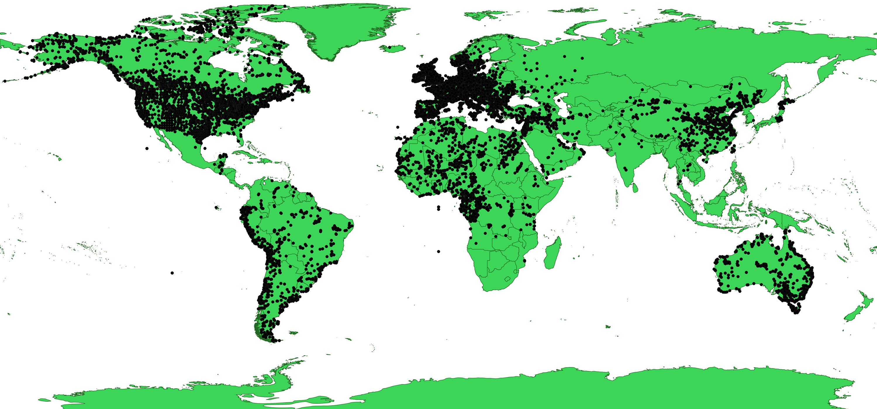
This workshop aimed to broaden the geographic scope of the WG and incorporate more early-career researchers (ECRs). We accomplished this goal. ECR attendees specialized in the archaeological and paleoenvironmental data of Central America, Europe, Southwest Asia, Central Asia, and Northern Africa attended the meeting. This enabled us to expand our archaeological radiocarbon dataset to ca. 130,000 dates (Fig. 1). We had a computer scientist attend the meeting in order to facilitate the integrated development of this radiocarbon dataset and overcome the various metadata obstacles to comparative global-scale analyses. This dataset is now the largest archaeological radiocarbon dataset in the world, and overcoming the various metadata obstacles presents unprecedented opportunities for the study of human population ecology. A new collaboration with the LandCover6k project was furthered by the attendance of one of their group leaders at this workshop. Synergies are bound to emerge between these PAGES WGs from the use of the archaeological radiocarbon database as a resource for establishing population growth rates for different regions of the world that in turn can be used to provide baselines for anthropogenic land-use models.
 |
|
Figure 1: Locations of all archaeological radiocarbon dates in the PEOPLE 3000 database. |
First steps were taken at this workshop to overcome the central challenge of integrating archaeological, paleoclimate, and paleoenvironmental data. This challenge is largely caused by gaps in the spatial and temporal coverage of these different records, and the impacts these gaps have on data resolution and our ability to identify correlations and possible causal processes. In order to overcome these challenges, the P3k WG has developed a new method for modeling human paleodemography according to transient paleoclimate model simulations, rather than modern nation-state boundaries (Robinson et al. 2019). We turned to PaleoView (Fordham et al. 2017) to extract continuous climate model simulation data for every region from which we have significant amounts of archaeological radiocarbon data. We then acquired multi-proxy paleoenvironmental data for each of these regions in order to start comparing PaleoView to multiple proxy records from different regions. Comparative studies of PaleoView and regional paleoenvironmental records will enable us to identify relevant key ecological parameters for "tipping points" in human social-ecological systems.
The workshop included several public outreach engagements including tours of local archaeological and rodent midden (paleoecological) sites at Dinosaur National Park, a guided tour of the McConkie Ranch rock art panels, and an open house held at the Uintah County Museum. During the open house, scholars from the P3k WG invited members of the public for an evening of conversation about climate-smart food systems. Conversations focused on insights made possible through the interdisciplinary work of archaeologists and paleoecologists from around the world. Together, workshop participants and community members explored strategies, successes, and failures from local contexts and shared perspectives for developing climate-smart food systems for our futures.
P3k WG participants gave in-depth interviews on their research, workshop experience, and collaboration. These interviews will be made available to the public through online podcasts, videos, and Utah Public Radio segments to be aired in early 2020.
Access the poster highlighting these outreach events at pastglobalchanges.org/products/pages-outreach/12884
affiliationS
1Department of Sociology, Social Work, and Anthropology, Utah State University, Logan, USA
2Department of Ecology, Pontifical Catholic University of Chile, Santiago, Chile
contact
Erick Robinson: erick.robinsonusu.edu
references
Angela V. Gallego-Sala1, J. Loisel2 and M. Garneau3
University of Exeter, UK, 1-4 May 2019
Members of the C-PEAT working group (pastglobalchanges.org/c-peat) met at Exeter University for the first meeting of Phase II of the working group. The aim of the workshop (calendar/26937) was to discuss the more recent (post-industrial) role of peatlands in the carbon cycle and the ecosystem services (ES) they have provided and will continue to provide in the future.
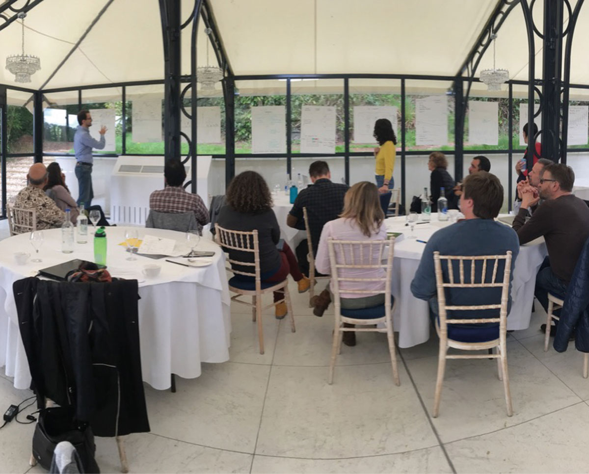
In our planning meeting in Texas last year, the C-PEAT scientific committee highlighted the need to predict peatland responses to anthropogenic disturbances, so integrating human impacts on ecosystem functioning was integral to this workshop. The discussion was divided into two topics/days: 1) carbon cycling in peatlands since the Industrial Revolution and 2) other ES provided during this period. Workshop participants included not only the habitual peat paleo community but, in addition, we invited peatland flux scientists, peat modelers, peatland stakeholders and ES experts, including several tropical peatland experts. Bringing different expertise into the same room allowed for interesting presentations, group discussions and brainstorming exercises (Fig. 1).
 |
|
|
Carbon cycling in peatlands
Under this heading the community worked towards bringing together ongoing efforts to gather regional, national and global databases of the recent carbon accumulation records in peatlands. The brainstorming work focused on many topics including: 1) developing a better analysis of this part of the record to tease out allogenic versus autogenic drivers of carbon accumulation, 2) locating the carbon accumulation hotspots on a global scale, and developing a peatland health index based on existing peat carbon data syntheses, 3) identifying the changes in radiative forcing of peatlands driven by recent changes using regions with high data density (Canada and Fennoscandia), and 4) exploring the economic impacts of the carbon sink loss brought about by anthropogenic impacts. The meeting produced many ideas for future work and direction of research within the community, including the preparation of at least two community manuscripts that will present key results from the aforementioned research objectives.
Other peatland ecosystem services provision
We discussed current and future peatland ES, including ongoing restoration efforts and loss of ES in different areas around the globe. In particular, we discussed what the paleo record may tell us about the changes in ES since the Industrial Revolution and how it may inform predictions of future trajectories of ES. Besides carbon regulation, workshop participants identified a suite of ES and their relative importance across different regions of the world. For example, while Andean peatlands are most significant for water provision and regulation, those from the Indonesian lowlands matter most in terms of their food provisioning, biodiversity hotspot and climate change mitigation capacity (Law et al. 2015). We also explored how the C-PEAT paleo peat community may inform management of these important ecosystems and planned two outcomes that represent our first steps in working more closely with practitioners and other stakeholders: 1) policy briefing note – the community will produce a note for policymakers highlighting the main drivers of carbon accumulation of peatlands to help them make better decisions to improve ecosystem management; 2) Marie Skłodowska-Curie Innovative Training Network – the community will apply for a EU-funded training network in January 2021 using contacts with stakeholders to strengthen the application.
Next steps
One of the next steps for C-PEAT is to better integrate tropical and extra-tropical peatlands in the databases, an attempt already started in one of the latest community papers (Gallego-Sala et al. 2018). To achieve this, our next meeting will be held in May 2020 in Bangkok, Thailand, with a focus on tropical peatlands.
Acknowledgements
We thank PAGES, INQUA, NSF, and the College of Life and Environmental Sciences at the University of Exeter for financial and logistical support.
affiliations
1Department of Geography, College of Life and Environmental Sciences, University of Exeter, UK
2Department of Geography, Texas A&M University, College Station, USA
3Department of Geography and Geotop, Université de Québec à Montréal, Canada
contact
Angela Gallego-Sala: a.gallego-salaexeter.ac.uk
references
Brittany Marie Ward1, T. Pollard2, E. Corrick2 and O.A. Dumitru3
Cluj-Napoca, Romania, 11-17 August 2019
Speleothem science is a rapidly growing discipline in the field of paleoclimatology. The application of speleothem-based research includes diverse topics such as the reconstruction of sea-level rise (Dumitru et al. 2019), assessment of monsoon dynamics (Dykoski et al. 2005), exploration of human-climate relationships (Pickering et al. 2019), calibration of the radiocarbon timescale (Noronha et al. 2014), precisely dating of the timing of global abrupt climate changes (Moseley et al. 2014), and many more. The necessity of a student-focused training school on this topic was acknowledged in 2011 by a group of PhD students, who went on to hold the inaugural Summer School on Speleothem Science (S4) in Heidelberg, Germany, in 2013. At its core, S4 has remained a student-led initiative and was subsequently held in Oxford, UK (2015) and Burgos, Spain (2017).
The fourth iteration of S4 was hosted at the Babeș-Bolyai University in Cluj-Napoca, Romania, from 11-17 August 2019 (speleothemschool.com). The school was the largest S4 yet, with 63 early-career participants from 24 countries, as well as 19 invited lecturers, in attendance. The four-day academic program consisted of lectures, workshops, a career development panel, and two poster sessions, in which participants presented their current research. The academic component of the school covered fundamental aspects of speleothem science in a lecture format, generated valuable discussion between participants and experts during question periods, and aimed to create a welcoming atmosphere to integrate early-career speleothem researchers into the field of speleothem science. The lecture program covered fundamental topics in speleothem science, such as speleothem formation and stable isotope analysis, but also included discussion of frontier research topics, such as characterization of cave-system hydrology using advanced geophysical imaging methods, exploration caving being undertaken in Northeast Greenland, and new speleothem drip-rate proxies based on the dissociation kinetics of trace metal-organic ligand complexes. The workshop program also introduced participants to a selection of software packages relevant to the field, including COPRA (depth-age modeling software), PHREEQC (geochemical modeling), and CaveCalc (cave drip water and speleothem chemistry modeling), as well as a hands-on session on uncertainties in timeseries analysis.
 |
|
Figure 1: S4 2019 participants touring the immaculately decorated Bears' Cave of Chişcău, Romania, where Emil Racoviță Institute of Speleology researchers are undertaking cave sediment and paleontological research. |
The academic program was followed by a two-day field trip to the Apuseni Mountains of Transylvania. Participants were guided by Babeș-Bolyai University and Emil Racoviță Institute of Speleology researchers to Transylvania's impressive karst landscape, visiting the world-renowned Meziad Cave, Bears' Cave (Fig. 1), and the impressive Scărișoara Ice Cave. Participants were able to gain an appreciation of speleothem formation environments, see examples of cave monitoring stations, practice interpreting stalactite patterns on the cave roof, and see firsthand a 15 m-thick cave glacier that has yielded a 10,000-year-old paleoclimate record. Participants came together for a traditional Romanian dinner during the field trip in the Hotel Perla Apusenilor and were treated to a performance of Romanian folk music with alphorns.
The 2019 Organizing Committee aims to provide lasting resources to S4 2019 participants and other speleothem researchers by sharing the S4 2019 Course Notes, which are now available via the S4 ResearchGate profile (researchgate.net/project/Summer-School-on-Speleothem-Science). Further, the S4 aims to establish a strong social media presence on both Twitter and Instagram. These platforms can be used to advertize upcoming workshops in the broader field of speleothem science, highlight new research and generate discussion within the community, spread the word of PhD, postdoctoral, and faculty positions, and share stories from the lab and the field. Follow S4 at @SumSchSpelSci on Twitter and @s4_speleothem on Instagram.
The S4 provides a unique opportunity for international networking in a casual and inclusive setting, fostering relationships between early-career researchers, and bringing together the future of Speleothem Science. We look forward to passing the torch to the S4 2021 Organizing Committee.
Acknowledgements
We thank the Babeș-Bolyai University, PAGES, the International Association of Sedimentology (IAS) and the European Geoscience Union (EGU) for their financial and logistical support that made this event possible.
affiliationS
1Environmental Research Institute, University of Waikato, New Zealand
2School of Geography, The University of Melbourne, Australia
3School of Geosciences, University of South Florida, USA
contact
Brittany Marie Ward: brimwardgmail.com
references
Dumitru OA et al. (2019) Nature 574: 233-236
Dykoski CA et al. (2005) Earth Planet Sc Lett 233: 71-76
Moseley GE et al. (2014) Geology 42: 1043-1046
Anupama Krishnamurthy1, M.-J. Gaillard2, S. Prasad1 and K.D. Morrison3
Pondicherry, India, 11-14 September 2019
This four-day workshop of the working group LandCover6k (pastglobalchanges.org/landcover6k) hosted at the French Institute of Pondicherry emphasized hands-on training in pollen-vegetation modeling methods and fieldwork protocols for pollen-based land-cover reconstructions (LC) and archaeology-based land-use mapping (LU). The training was provided by LandCover6k members to a group of mainly ECRs and also senior palynologists, ecologists, archaeologists, and historians working in South and Southeast Asia (45 participants).
The first day included presentations on:
- LandCover6k, its activities, and the state-of-the-art methods for achieving pollen-based LC reconstructions using the Regional Estimates of VEgetation Abundance from Large Sites (REVEALS) model (Sugita 2007).
- Archaeology-based LU mapping, including per-capita land-use estimates and other quantitative information, e.g. regarding domestic animals and crops (Morrison et al. 2018).
- Establishing standard chronologies for pollen records with an introduction to chronology using radiocarbon dating and Bayesian age-depth modeling (Blaauw and Christen 2013).
The group discussions and 20 poster presentations facilitated exchanges on regional initiatives for achieving the goals of LandCover6k as well as an overview of a possible regional-scale data synthesis starting with homogenizing the attributions of pollen types and plant taxa of this region, including their ecological significance. Finally, Y. Subbarayalu gave a special lecture entitled "An independent LU data synthesis: Historical atlas of South India and its GIS database."
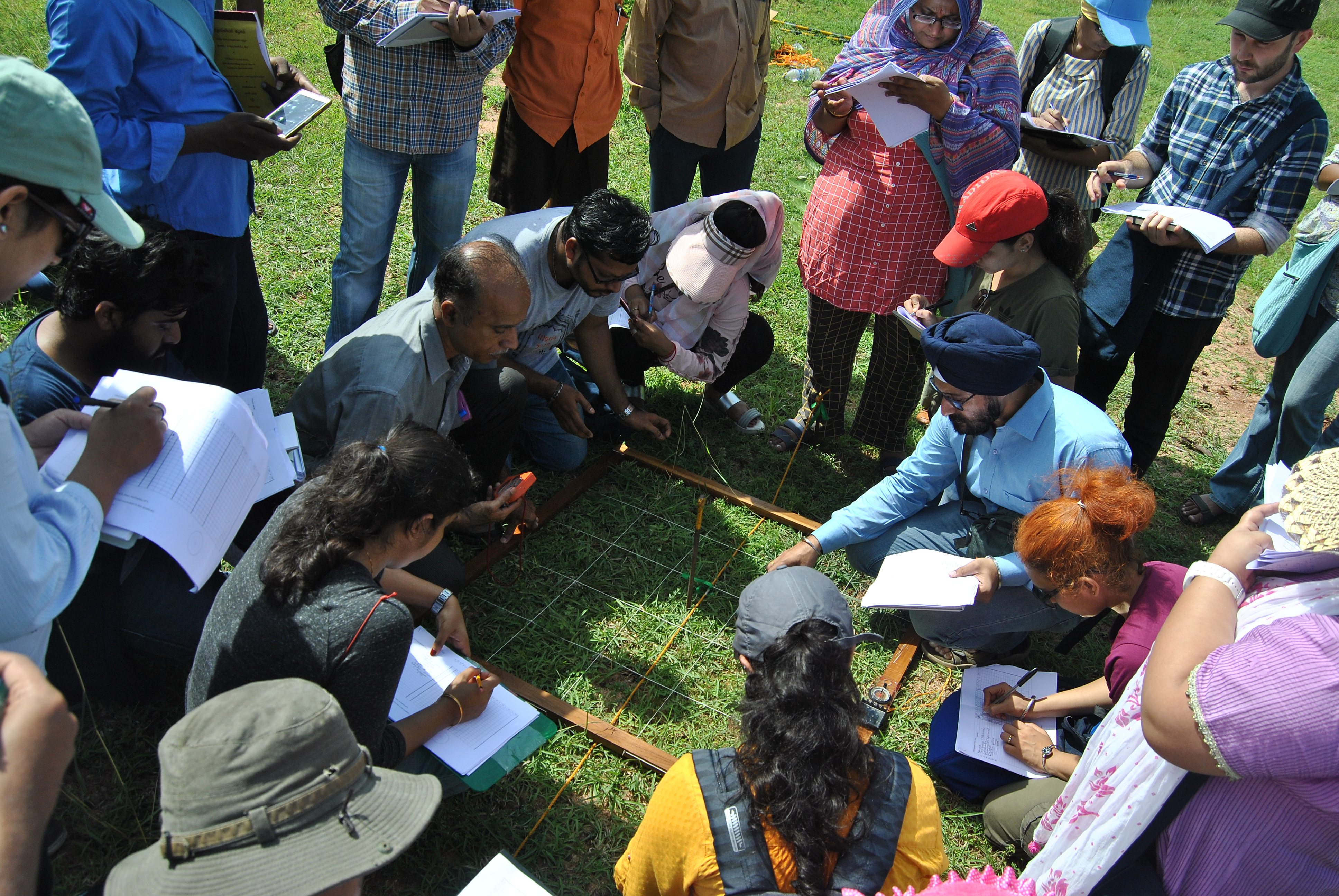
The second day, mainly in the field, introduced standard protocols for distance-weighted vegetation data (Bunting et al. 2013; Fig. 1) necessary to estimate Relative Pollen Productivities (RPPs, a key input in REVEALS) using the Extended R-Value (ERV) model, followed by discussions on the various regional challenges. A positive conclusion was the broad feasibility in tropical landscapes, given the new results from Southeast India (which will be published within the framework of Navya Reghu's PhD thesis) and Cameroon (Gaillard et al. 2019).
 |
|
Figure 1: Participants recording distance-weighted vegetation data as per protocol in tropical peninsular India. |
The remaining two days consisted of parallel sessions focused on LC and LU to achieve the overarching goals of the work packages WP-LC6 and WP-LU6 (pastglobalchanges.org/science/wg/landcover6k/scientific-goals), respectively.
The LC session included running ERV, REVEALS, and BACON age-depth models. The LU session focused on the application of the hierarchical scheme of global land-use classes used in LandCover6k and the effective use of Google Earth for LU mapping. The LU group capitalized on the participants' expertise by continuing work on correcting and completing paper maps produced during the regional LandCover6k initiative started a few months ago in Delhi under HoLa, an International Focus Group of INQUA HABCOM (inqua.org/commissions/habcom/ifg). This allowed for the near completion of a basic land-use map for South Asia at 12 kyr BP, 6 kyr BP, 4 kyr BP, and CE 1500 for publication. The plenary discussion sessions on the relevance of regional paleo and historical databases had a special focus on NEOTOMA (Williams et al. 2018), including a brief demonstration of the database. A special lecture by Shanti Pappu and Kumar Akhilesh provided perspectives on the changing archaeological landscape of South India through the Quaternary with public outreach insights.
During the final plenary, workshop participants discussed the available Holocene pollen data, including modern pollen-vegetation datasets from different ecological zones (WP-LC6) and the pressing need for a regional historical database (WP-LU6). It was decided to move forward with WP-LC6 in two ways in at least four distinct ecological zones where sufficient data and ongoing studies are available (Central Indian forests, Western Himalayas and Kashmir, Coastal Mangroves, Sri Lanka):
- Initiate fieldwork using the standard protocol for collection of pollen-vegetation data demonstrated during the workshop to obtain new estimates of RPPs for major plant taxa of the region.
- Use the numerous existing modern pollen samples to validate available RPPs from other regions, such as China and Europe (Li et al. 2018; Mazier et al. 2012), for common plant taxa in e.g. the Western Himalayas and Kashmir, and test newly obtained RPPs from Southern India in the Central Indian forests.
It is feasible to extend these LC and LU goals in Cambodia, Vietnam, and Indonesia in the next year or two. In terms of databases, using available ones like NEOTOMA seemed most practical; however, the addition of a regional web portal would be useful. This workshop (pastglobalchanges.org/calendar/26830) allowed the LU group (WP-LU6) to propose a roadmap for a regional historical database: to begin setting it up at the University of Pennsylvania where it is technically feasible to do so immediately and to eventually move it to a host institution in South/Southeast Asia.
affiliations
1Department of Ecology, French Institute of Pondicherry, Pondicherry, India
2Department of Biology and Environmental Science, Linnaeus University, Kalmar, Sweden
3Department of Anthropology, University of Pennsylvania, Philadelphia, USA
contact
Anupama Krishnamurthy: anupama.kifpindia.org
references
Blaauw M, Christen JA (2013) [Date accessed: 31.10.2019] Bacon Manual V2.2
Bunting MJ et al. (2013) Quat Sci Rev 82: 41-55
Li F et al. (2018) Front Plant Sci 9: 1214
Mazier F et al. (2012) Rev Palaeobot Palyno 187: 38-49
Morrison KD et al. (2018) PAGES Mag 26: 8-9
Rosie R. Bishop1 and Marc Vander Linden2
Hemmenhofen, Germany, 28-30 January 2019
The PAGES LandCover6k (pastglobalchanges.org/landcover6k) Europe group workshop (pastglobalchanges.org/calendar/2019/127-pages/1884), hosted by Dr. Elena Marinova at the Research Center for Wetland Archaeology in Hemmenhofen, Germany, was attended by an interdisciplinary group of European researchers, which included archaeobotanists, zooarchaeologists, landscape archaeologists, and environmental scientists.
The workshop built on discussions from two earlier LandCover6k Europe group workshops in 2018 (both in Barcelona, Spain) and research that had been undertaken by the group over the past year.
The workshop focused on several key themes:
- Evaluating the project methodologies for mapping land use.
- Evaluating initial regional European land-use maps for the period 4250-3750 cal BCE (6000 BP).
- Refining definitions of land use for global mapping and the categories for the accompanying database of sites.
- Data ownership and plans for future publications from the project.
Day one involved a series of presentations from different participants. The workshop began with a welcome address from Dr. Renate Ebersbach, the director of the research center. Following this, the European group coordinators, Dr. Nicki Whitehouse (University of Plymouth, UK), Prof. Marco Madella (UPF, Barcelona, Spain) and Dr. Ferran Antolin (University of Basel, Switzerland), updated the group on progress since the previous meeting and introduced the agenda for the workshop.
Dr. Oliver Boles (University of Pennsylvania, USA) presented the definitions of land use that will be used for mapping, and there was discussion regarding the standardized categories to be used for the database of site information that will accompany the maps. It is necessary to develop standardized definitions of different types of land use (e.g. hunter-gathering, pastoralism) to enable global comparisons to be made (Morrison et al. 2018).
This discussion was followed by a series of papers reviewing methodological issues for modeling past land use. Dr. Marc Vander Linden (University of Cambridge, UK) updated the group on the site mapping that had been undertaken since the previous meeting and explained the decision to use kernel densities to map European land use. Prof. Sandy Harrison (University of Reading, UK) then outlined the types of information needed as input for climate models and how archaeologists can provide relevant data or improve existing estimates based on expert knowledge. Key information modelers require include: the dates of first agriculture and percentage of agricultural land, estimates of population growth, how much biomass was removed (percentage of different crops and domestic animals, as well as mass density in kg/m2 of wood and nuts harvested), and the mix of C3 versus C4 crop plants grown. Finally, Dr. Tilman Baum (University of Basel, Switzerland) discussed a modeling land-use case study in the Alpine Foreland using agent-based simulations.
 |
|
Figure 1: Distribution of the regional sub-groups (Northwest Europe, Northern Europe, Southeast Europe, Southwest Europe). |
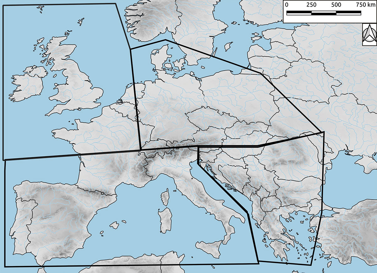
In the second part of the meeting, the preliminary land-use maps generated at a previous meeting in May 2018 (Whitehouse et al. 2018) were evaluated by regional sub-groups (Northwest Europe, Northern Europe, Southeast Europe, Southwest Europe; Fig. 1) to establish data gaps and errors. The initial maps were constructed using expert knowledge, together with a European database of radiocarbon dates collated by Dr. Marc Vander Linden and subsequent data collections by the group.
Day two focused on refining the standardized categories that will be used in the database of sites to accompany the maps, and discussing the plans for papers that will be produced from the project.
Future research
The project team is currently working to fill in gaps in datasets. The aim is to produce initial land-use maps using basic top-level classifications of land use (e.g. hunter-gathering/agriculture) to allow climate modelers to test whether human impacts on land cover in prehistory were large enough to influence climate change. The datasets will be increasingly refined and used to produce more detailed maps that will incorporate information on different hunting and gathering, farming, and fuel-procurement strategies. It is hoped that the final output of the project will prove useful for both the modeling and archaeological communities.
affiliations
1Department of Archaeology, Durham University, UK
2Department of Archaeology, University of Cambridge, UK
contact
Rosie Bishop: rosierosiebishop.com
references
Chantal Camenisch1, M. Bauch2, H. Huhtamaa3, Q. Pei4 and S. White5
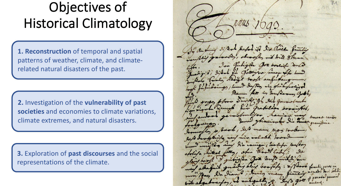
Historical climatology is the interdisciplinary field that explores past climates and the human dimension using written records, human artifacts, and early instrumental measurements, collectively termed "the archives of societies". These sources range from chronicles, diaries, and newspapers to flood markers on historic buildings and pre-standard thermometer and barometer readings (Brázdil et al. 2005; Fig. 1).
Research in historical climatology may both complement and extend research in paleoclimatology (Brönnimann et al. 2018). Similar to high-resolution natural archives, the archives of societies may contain proxies for one or more climate parameters dating back as far as several millennia, depending on the region and approach. Archives of society have the advantage of possibly containing seasonal or even monthly information and are not restricted to a particular period (e.g. the growing season). This factor may permit full-year reconstructions utilizing a single approach. In addition, written historical records may provide detailed meteorological descriptions and narratives enabling investigations of historical climate as well as weather impacts and adaptations.
Nevertheless, using the archives of societies poses significant challenges. Their information is neither as continuous nor homogenous as that provided by natural proxies, and their quantity and quality vary by region and tend to diminish further back in time. Historical climatology requires careful interpretation to overcome problems of subjectivity and errors of recording and transmission. Historical climatologists in different regions of the world have independently developed methods to address these problems but have not yet coordinated global best practices in source interpretation or production of data, nor has the field established clear language and standards for the attribution of past societal change to climatic variability and change.
Scientific goals
The recently established PAGES working group Climate Reconstruction and Impacts from the Archives of Societies (CRIAS, pastglobalchanges.org/crias) aims to improve methods in historical climatology and to coordinate global best practices in source interpretation and production of data, especially for use by paleoclimatologists and modelers. To this end, three main goals have been defined:
 |
|
Figure 1: Objectives of Historical Climatology (Brázdil et al. 2005) and examples of archives of society: page from a weather diary from a monk in Einsiedeln, Switzerland, written at the end of the 17th century. Credit: Diarium P. Josef Dietrich, Bd. 8 (1692-1694) (KAE, A.HB.8, S. 71) klosterarchiv.ch/e-archiv_archivalien.php |
1) Sharing methods among historical climatologists working in different regions to exchange best practices and ensure the compatibility of results
In East Asia and Europe, in particular, research in the field of historical climatology already has a long tradition. One goal of CRIAS is to intensify discussions regarding standards of source criticism and reconstruction methods among scholars from these two regions and to extend this discussion to other continents. This process has begun with a comprehensive worldwide review of methods for creating climate indices.
2) Working with paleoclimatologists and modelers to determine whether and how data drawn from the archives of societies may inform their research (and vice versa)
A closer collaboration between historical climatologists and paleoclimatologists seems very promising. To enable such a discussion, it is necessary to explore ways to solve problems derived from inhomogeneous records in the archives of society, the loss of low-frequency variability, and the treatment of uncertainties in reconstructions based on the methods of historical climatology.
3) Communicating standards of climatic causation used in historical research, especially for the benefit of natural and social scientists whose work has historical human dimensions
As with other interdisciplinary fields, historical climatology must deal with diverging disciplinary concepts, standards, and language used to address causality. This challenge arises particularly in the attribution of past societal changes to climatic variability or change. In order to avoid confusion among scholars in different disciplines as well as overly deterministic statements, CRIAS aims to promote more rigorous standards and language in historical climate impact and adaptation research.
Working group activities
In October 2018, a first workshop on "Methods and Interdisciplinary Communication in Historical Climatology" was organized in Bern, Switzerland (Camenisch et al. 2019). A second workshop was held in October 2019 in Leipzig, Germany, on "Integrating Documentary Evidence into Climate Reconstruction and Impact Studies" (dantean.hypotheses.org/crias), and a third workshop is scheduled in the second half of 2020 in Hong Kong. As a result of these activities, several papers and special issues are in preparation.
affiliations
1Oeschger Centre for Climate Change Research and Section of Economic, Social and Environmental History, University of Bern, Switzerland
2Leibniz Institute for the History and Culture of Eastern Europe, Leipzig, Germany
3Heidelberg Centre for the Environment, Germany
4Department of Social Sciences, Education University of Hong Kong, China
5Department of History, Ohio State University, Columbus, USA
contact
Chantal Camenisch: chantal.camenischhist.unibe.ch
references
Brázdil R et al. (2005) Clim Change 70: 363-430
Brönnimann S et al. (2018) In: White S et al. (Eds) The Palgrave Handbook of Climate History. Palgrave Macmillan, 27-36
Jacob Freeman1,2, E. Robinson1, C. Latorre3 and M. Cannon1
The prehistory of human-environment interactions is a source of knowledge critical for meeting the challenges of a globalizing planet confronting population growth and climate change. The PEOPLE 3000 working group (pastglobalchanges.org/people3000) combines archaeological and paleoecological case studies with mathematical modeling to investigate how co-evolving human societies and ecosystems can successfully cope with the interrelated forces of globalization, population growth, and climate change, and why, in some cases, societies fail to cope with these interrelated forces and reorganize accordingly.
PEOPLE 3000 has two interrelated objectives. First, we seek to describe and explain basic patterns of human population ecology by building large radiocarbon datasets and integrating these datasets with paleoenvironmental datasets and formal, mathematical models. Second, we seek to evaluate concepts from contemporary policy documents from the long-term perspective offered by the integrated analysis of formal models, radiocarbon, and paleoenvironmental datasets.
For example, Freeman and colleagues synthesized and used large datasets of archaeological radiocarbon to document that the energy output of human societies over the last 10,000 years displays synchrony – the simultaneous fluctuation of human populations (Freeman et al. 2018). Synchrony is a well-documented process in the population ecology of non-human animals, but this was the first time it was described among human populations. This work describes a basic population ecology process – synchrony – that may be used to inform sustainability research. Preliminary evidence suggests that human synchrony results from globalization rather than simultaneous responses to climate. Similarly, Robinson et al. (2019) integrate radiocarbon records with downscaled, transient paleoclimate models to examine how the distribution of population in the Western USA and climatic zones coevolved over time. They find strong evidence of climate-zone filling and the "packing" of people into climate zones over time, which may have contributed to late Holocene population collapses.
Finally, in one of our ongoing projects, PEOPLE 3000 is evaluating the policy concept of "climate-smart agriculture". Climate-smart agriculture mitigates ecological degradation, enhances productivity, and maintains the robustness of production to climate change (Lipper et al. 2014). Yet, the relationships between these "triple win" processes are not well understood over the long term. In fact, these tenets conflict with a large body of theory. Models from resilience theory suggest that increasing productivity necessarily means giving up robustness (Carpenter et al. 2015). Large datasets of archaeological radiocarbon allow us to study the fundamental process of population stability to evaluate whether prehistoric societies undergoing population growth and climate change achieved simultaneous increases in the productivity and the robustness of agriculture or traded these off. Our results suggest partial support for the core tenet of climate-smart agriculture that societies can simultaneously increase productivity and robustness (Fig. 1).
 |
|
Figure 1: (A) The first difference of summed probability distributions of radiocarbon from mixed forager-farmer and specialized farming societies in North and South America over the last 4000 years cal BP. (B) Density plots of the size of first difference (amplitude of change) and the density of such changes among mixed forager-farmer and specialized farming systems. Note, most changes are small, but a few changes are large. (C) Power functions fit by regressing the log of the size of fluctuation on the log of the proportion (density) of fluctuations. Mixed forager-farmers have a shallower slope indicating more sensitivity to disturbance (more moderate-sized amplitudes of change). Specialized systems have a steeper slope indicating less sensitivity to disturbance. |
Over the next year, PEOPLE 3000 seeks to expand our coverage to develop biogeographic analyses of human energy dynamics and continue to evaluate policy concepts using the long-term perspective provided by paleorecords. Specifically, we will:
- Develop records of paleoclimate and, more importantly, ecosystem change to integrate with a cutting-edge, global dataset of archaeological radiocarbon.
- Expand our current global archaeological radiocarbon datasets, add additional proxies for population and economy size, and publish the expanded dataset.
- Publish papers that use the long-term perspective offered by the integration of formal models and paleodata to evaluate basic concepts from the sustainability literature.
- Collaborate with the LandCover6k working group by developing population growth rates for different regions of the world that will provide baselines for anthropogenic land-use models.
- Build community outreach through our museum partners and exhibits based on the results of PEOPLE 3000 research.
PEOPLE 3000 is an exciting and open network committed to pushing the boundaries of research in human population ecology to provide a firmer foundation for understanding the concept of sustainability. Join our mailing list to receive updates! listserv.unibe.ch/mailman/listinfo/people3000.pages
affiliationS
1Department of Sociology, Social Work, and Anthropology, Utah State University, Logan, USA
2The Ecology Center, Logan, USA
3Department of Ecology, Pontifical Catholic University of Chile, Santiago, Chile
contact
Jacob Freeman: jacob.freemanusu.edu
references
Carpenter SR et al. (2015) Proc Natl Acad Sci 112: 14384-14389
Freeman J et al. (2018) Proc Natl Acad Sci 115: 9962-9967