PAGES Magazine articles
Rob Marchant1 and Stephen Rucina2
East African LandCover6K, Nairobi, Kenya, 22-23 October 2015
The East Africa LandCover6k workshop brought together over 60 experts from the fields of archeology, archeobotany, linguistics and paleoenvironmental studies to synthesize information on East African land-cover change over the past 6000 years. Through an exchange of ideas, the interdisciplinary group aims to understand directions and drivers of land-cover change, and the interaction with various cultures, technologies, and subsistence strategies across the East African region. The workshop outputs were a series of templates for capturing information on land-use and socioecological change that are currently being populated by the wider community. Ultimately this will lead to a series of land-cover maps for Eastern Africa collated within a review manuscript and harmonized with parallel initiatives from other parts of the African continent. The participants also discussed the utility of East African land-cover-change data for a range of different disciplines, particularly for stakeholders outside of academia concerned with contemporary issues such as resource use and conservation.
 |
|
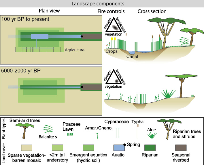
Figure 1: Landscape change inferred from a dated pollen record taken at Esambu swamp, Amboseli, southern Kenya. The mid to late Holocene landscape was characterized by open semi-arid woodland with disjointed fuel connectivity. Through the late Holocene, the catchment was increasingly modified by human activity characterized by channeling water resources and expanding agriculture with fire activity increased. |
The workshop focused on the following questions: (1) What were the dominant land-cover changes during the past 6000 years? (2) What are the key gaps in the archeological and paleoenvironmental records? (3) Were the drivers of land-cover changes natural or anthropogenic? (4) What contemporary questions about human-environment interaction can our data and modeling initiatives help to address?
As one of the core aims of the LandCover6k project is to provide global maps of land cover to feed into climate-model development, Jed Kaplan (U. Lausanne, Switzerland) provided a model-based perspective on land-cover changes in West Africa over the past 6000 years. We then had two overview presentations on the current status and future directions of archeological and paleoecological research in Eastern Africa by Paul Lane (Uppsala U., Sweden) and Dan Olago (U. Nairobi, Kenya) respectively. The workshop then moved to a series of country-specific sessions where current overviews on archeology and paleoecology data were presented as a series of paired talks for Central Africa, Tanzania, Uganda and Kenya.
The second day of the workshop focused on the wider application of land-use data for conservation by Cassian Mumbi (Tanzania Wildlife Research Institute) and Jaqueline Barnard (Kenya Wildlife Service). We then focused on the link to natural resource use, specifically on water by Dickens Odeny (National Water Towers Project, Kenya), Philip Omondi (Kenya Meteorological Department), and carbon by Jennifer Farmer (ALTER Carbon project, Uganda).
Workshop participants then divided into three groups. The first, led by Jed Kaplan, focused on developing a matrix to capture data (stratigraphic, radiocarbon, proxy, artefacts and land use) and meta information (site location, age range covered and environmental setting) that has been subsequently developed and will underpin the synthesis. Rob Marchant led another group on collating information around phases of rapid environmental or technological and land-cover change, particularly looking at the periods around 4000 and 800 years BP. Stephen Rucina led the final group, looking at the spread of archeological data and how this can be used for land-use change study. The East Africa LandCover6k initiative is currently in the phase of collating data and information behind land use that will be discussed at forthcoming congresses and feed into the wider development of the LandCover6k project.
For more information on the workshop, or to be involved in the East Africa LandCover6k project, please contact Rob Marchant: Robert.marchant york.ac.uk
affiliationS
1Environment Department, University of York, Heslington, UK
2National Museums of Kenya, Nairobi, Kenya
contact
Rob Marchant: robert.marchantyork.ac.uk
Kathleen D. Morrison1, M.-J. Gaillard2, M. Madella3, N. Whitehouse4 and E. Hammer5
LandCover6k workshop, Paris, France, 22-23 October 2015
LandCover6k builds Holocene land-cover reconstructions for the purpose of climate modeling (Gaillard et al. 2015), with a focus on anthropogenic land-cover change (ALCC). Existing ALCC models vary significantly (Gaillard et al. 2010), highlighting the need to evaluate and improve model outputs using paleoenvironmental data, here primarily pollen data. While pollen-based land-cover data provide checks on, or alternatives to, ALCC models, they do not address the causal relationships underlying human modification of environments, which stem from past land-use practices. Land-use practices vary significantly across regions so that, for example, extrapolations from temperate zone cases almost certainly misrepresent the impact of farming in the tropics, or in regions without large animal domesticates (Morrison 2015). Further, similar numbers of people in the same environment practicing different forms of land use will have different effects on vegetation. Because the environmental effects of human population are mediated by land use, they are a challenge to model.
 |
|
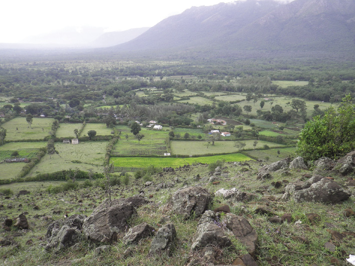
Figure 1: Masinagudi, Tamil Nadu, India. Grazed hill in foreground, tree-bordered fields in middle ground, and forested slopes of the Nilgiri Hills in background. Farmers in this semi-tropical region grow subsistence crops such as rice and pulses as well as spices and other cash crops; nearby forests have been closed for wildlife protection. Prior to the loss of forest access, local farmers practiced forms of agroforestry which maintained denser woody cover. Population figures have not changed significantly, but land-use changes have led to differences in regional vegetation through time (photograph KD Morrison). |
The land-use group (group 6) of LandCover6k integrates and maps historical, archeological and geographic data on human land use over the last ten thousand years. To accomplish this, new modes of data sharing, classification and data management need to be developed. Therefore, the goals of the workshop were to: (1) build this new research community; (2) explain the goals of LandCover6k; (3) develop basic global-scale, land-use categories applicable to the entire project; and (4) evaluate requests from the climate-modeling community for information on past human activities such as burning, tillage, livestock grazing and wood harvest.
Although designed as the first meeting of land-use coordinators for each of the continental-scale groups, the meeting was open to all. Forty-four people from 15 countries attended, including pollen analysts, modelers and representatives from PAGES’ Global Paleofire Working Group. The workshop focused on the problem of land-use classification; many existing classifications conflate land cover and land use (“forest”, for example, is not a land-use category as people may use forests in diverse ways) and thus cannot be used for this purpose. Our land-use classification is both hierarchical and scalable, with a small number of categories at the highest level, and more in each of the two lower levels. Participants agreed the highest, global-scale level of categories applicable from the early Holocene to CE 1850 will be: (1) no evidence for human land use, (2) foraging (hunting and gathering), (3) farming, (4) pastoralism, and (5) urbanism and/or extractive land use (such as mining or quarrying).
Additional subgroups were created, including: (1) separate groups for the CE 1500 and 1850 time windows where strict research separation between historians and archeologists exists, (2) a new group for the Mediterranean and Middle East, and (3) separation of Eastern and Western Europe. Data collection and management issues dictate most of these changes; global-scale synthesis is still planned.
Further details can be found on the LandCover6k website www.pastglobalchanges.org/ini/wg/landcover6k/intro, and the LandUse6k website http://landuse.uchicago.edu/.
affiliationS
1Anthropology, University of Chicago, Chicago, USA
2Biology and Environmental Science, Linnaeus University, Kalmar, Sweden
3Humanities, University Pompeu Fabra, Barcelona, Spain
4Geography, Earth, and Environmental Sciences, Plymouth University, UK
5Oriental Institute, University of Chicago, Chicago, USA
contact
Kathleen D. Morrison: morrisonuchicago.edu
references
Gaillard MJ et al. (2015) PAGES mag 23: 38-39
Gaillard MJ et al (2010) Clim Past 6: 483-499
Morrison KD (2015) Seminar 673: 75-80
Barbara Stenni1,2, M. Curran3,4, C. Barbante1,2 and M. Frezzotti5
Venice, Italy, 3-4 September 2015
The PAGES Antarctica2k working group met for two days in September 2015 in Italy. Fifty scientists, including PhD and graduate students, coming from 12 countries shared thier expertise in paleoclimate reconstruction methods, dating, ice cores, marine and lake sediments, borehole temperature, polar meteorology and climate modeling. The first objective was to plan two community papers, one focusing on a climate reconstruction using isotopic records from ice cores and other proxy records, the other on a snow-accumulation-rate reconstruction using firn and ice-core records. The second objective was to investigate the possibility to reconstruct the Antarctic sea-ice variability over the past 2000 years using proxy data from both marine sediment and ice cores.
The meteorological observations in Antarctica, a continent one and a half times the size of Europe, started only during the 1957-1958 International Geophysical Year with most of the stations along the coast and only some in the interior. For this reason, Antarctica’s past climate is only poorly documented. The interpretation of the isotopic profiles obtained from the ice cores allow to reconstruct the climate at different temporal scales from centuries to glacial-interglacial cycles, and can help fill in this spatial and temporal gap (Jouzel et al. 2007).
However, the snow deposition at the surface in Antarctica is spatially much less homogeneous than the original atmospheric precipitation (snowfall or diamond dust), due to wind erosion and redistribution, sublimation, and other processes during or after the precipitation events. For this reason, reconstructing past precipitation is a challenge.
The group discussed the state-of-the-art paleoclimate reconstructions from the high latitudes of the southern hemisphere. A particular emphasis was given to proxy interpretation and temperature calibration, highlighting the main challenges associated with ice-core water stable isotope records. The key factor controlling the isotopic proxy has been mainly related to temperature variations; however, this is not always straightforward and other processes acting on different spatial and temporal scales may influence this calibration. Early efforts to reconstruct the temperature history of Antarctica over the past 2000 years indicated that, at the continent-scale, Antarctica is the only land region where the long-term cooling trend of the last 2000 years has not yet been reversed by recent significant warming (PAGES 2k Consortium 2013). However, this reconstruction has large uncertainties and masks important regional-scale features of Antarctica’s climate evolution.
 |
|
Figure 1: Spatial correlation map (annual values, 1979-2014) of surface temperature for major ice-core drilling sites as simulated by the regional atmospheric model RACMO2.3 at 27 km resolution (courtesy of Melchior van Wessem and Michiel van den Broeke, Utrecht University). |
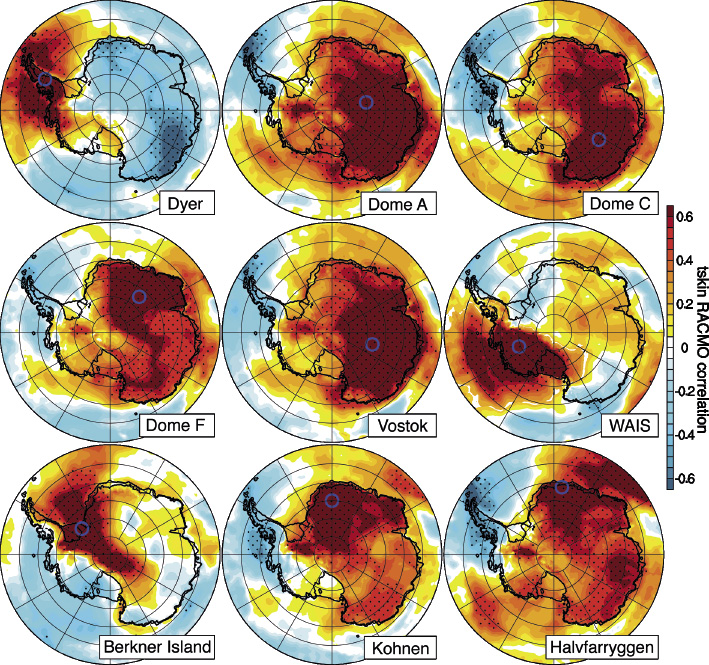
The group decided to expand the paleoclimate database and use new reconstruction methodologies aiming to reconstruct the climate of the past 2000 years at decadal scale and on a regional basis. Seven distinct climatic regions have been selected: the Antarctic Peninsula, the West Antarctic Ice Sheet, the East Antarctic Plateau, and four coastal domains of East Antarctica. This approach, supported by climate-model results (Fig. 1), will be applied to both isotopic and snow-accumulation-rate reconstructions.
The synthesis from ice-core records will be compared and evaluated against proxy data from marine and coastal terrestrial (e.g. lake, peat) records to shed light about possible different patterns between coastal/low-elevation and high-elevation regions in Antarctica. Moreover, a call for sea-ice proxy data has been launched and people within the sea-ice working group are working on implementation of the database.
If you would like to contribute to the current effort, or contribute data, contact working group leader Barbara Stenni.
Acknowledgements
The meeting was sponsored by PAGES, PNRA and DAIS (Ca’ Foscari University, Venice), under the patronage of SISC.
affiliationS
1Department of Environmental Sciences, Informatics and Statistics, Ca’ Foscari University of Venice, Italy
2Institute for the Dynamics of Environmental Processes, CNR, Venice, Italy
3Australian Antarctic Division, Hobart, Australia
4Antarctic Climate and Ecosystems CRC, University of Tasmania, Hobart, Australia
5ENEA, CR Casaccia, Roma, Italy
contact
Barbara Stenni: barbara.stenniunive.it
references
Joëlle Gergis1, A.M. Lorrey2, N.J. Abram3, B.J. Henley1, S.J. Phipps4, K.M. Saunders5 and workshop participants6
4th Australasia2k workshop, Auckland, New Zealand, 27-29 October 2015
This workshop, held at the National Institute of Water and Atmospheric Research (NIWA) in Auckland, reviewed research progress and identified potential contributions from the Australasian research community to Phase 2 of the PAGES 2k Network. The workshop included specialists in data collection, data synthesis, climate reconstruction and climate modeling, with increased involvement from lake-sediment and speleothem communities. This multidisciplinary group generated many insightful and collegial discussions that resulted in a highly productive workshop and the establishment of new collaborations.
The presentations showcased developments in data synthesis, climate modeling and new record development. Helen McGregor discussed a low-resolution sea surface temperature composite by the Ocean2k group (McGregor et al. 2015). Nerilie Abram presented the PAGES 2k Consortium effort focused on the onset of Industrial-era warming across oceans and continents. Mandy Freund presented a new Australian precipitation field reconstruction spanning the last millennium.
Hamish McGowan showed a 2100-year temperature reconstruction using a speleothem from New South Wales, Australia. Chris Moy linked high-accumulation lake records from southern South America and the Auckland Islands to changes in the Southern Hemisphere westerly winds. Ben Henley presented an Interdecadal Pacific Oscillation reconstruction from Pacific-wide paleoclimate data using the new Tripole Mode Index (Henley et al. 2015).
Work connecting proxy data and climate model simulations by Steven Phipps and Duncan Ackerley showcased data assimilation for Southern Hemisphere records using CSIRO Mk3L model simulations, and potential for conducting paleoclimate experiments using the Australian Centre for Water and Climate Research’s ACCESS model.
 |
|
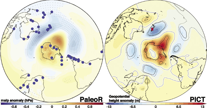
Figure 1: Southern Hemisphere spatial fields for austral summer near-surface atmospheric circulation (1450-1850 CE) based on PaleoR and PICT. PaleoR is based on a diverse range of proxy data from across the globe, while PICT is based on average paleotemperatures from 22 Southern Alps glaciers in New Zealand. Proxy data are independent and derived spatial fields are based on different datasets (PaleoR=climate model; PICT=modern reanalysis). There are broad similarities, along with regional confidence for different parts of the Southern Hemisphere. |
Bronwyn Dixon described the new Australasian “low resolution” database, which includes 536 non-annually resolved records from Australia and Indonesia. The highest quality records were identified and preliminary results presented. Stuart Browning gave a presentation on a new paleoclimate data and climate model-data assimilation method (Browning and Goodwin 2015) to develop a 1000-year reanalysis product called “PaleoR” (http://climatefutures.mq.edu.au/research/themes/marine/paleor/). Following this, Drew Lorrey showcased NIWA's Past Interpretation of Climate Tool (PICT; http://pict.niwa.co.nz), which applies modern analogues from reanalysis data to understand past circulation modes from paleoclimate data (Lorrey et al. 2013). A comparison of results derived from the PaleoR and PICT methods for the 1450-1850 CE period is shown in Figure 1. Lively discussions led by Ian Goodwin considered developing guidelines for future record collection in the Australasian region, framed around understanding regional and hemispheric climate dynamics.
Marcus Vandergoes presented progress developing high-resolution lake sediment records from New Zealand, followed by Krystyna Saunders’ precipitation reconstruction from Tasmanian lake sediments based on scanning visible reflectance spectroscopy. An interactive poster session highlighted progress on the climatic interpretation of Western Australian speleothem records by Pauline Treble; a new borehole temperature reconstruction for eastern Australia by Suman Asadusjjaman; sedimentary charcoal records from Pacific Islands by Matthew Prebble; and a new high-resolution Southern Hemisphere westerly winds reconstruction using sub-Antarctic lake sediments by Krystyna Saunders.
There was extensive discussion on regional “best practice” standards for proxy metadata reporting and compatibility with the LiPD framework (McKay and Emile-Geay 2016), existing geochronology protocols, ideas for new record collection that support a new metadata template, and a proposed article on this critical topic.
The workshop identified two contributions on regional hydroclimate synthesis papers, led by early-career researchers Mandy Freund and Bronwyn Dixon, for the planned PAGES 2k synthesis special issue. A proposed table of contents for a regional special issue for Climate of the Past was generated to showcase the diversity of new research being developed by the Aus2k community. The proposed submission timeframe is expected to span September 2016 to June 2017. Please contact a steering committee member if you are interested in contributing.
affiliationS
1School of Earth Sciences, University of Melbourne, Australia
2National Institute of Water and Atmospheric Research (NIWA), Auckland, New Zealand
3Research School of Earth Sciences, Australian National University, Canberra, Australia
4Institute for Marine and Antarctic Studies, University of Tasmania, Hobart, Australia
5Australian Nuclear Science and Technology Organisation (ANSTO), Sydney, Australia
6www.pastglobalchanges.org/calendar/all-events/127-pages/1490-4th-aus2k-wshop
contact
Joelle Gergis: jgergisunimelb.edu.au
references
Henley B et al. (2015) Clim Dyn 45: 3077-3090
Lorrey A et al. (2013) Clim Dyn 42: 3039-3060
McGregor HV et al. (2015) Nature Geosci 8: 671-677
McKay NP, Emile-Geay J (2016) Clim Past 12: 1093-1100
Ulf Büntgen1,2,3, F. Charpentier Ljungqvist4,5, J. Esper6, J. Luterbacher7, S. Wagner8, J.P. Werner9 and workshop participants10
Hemmenhofen, Germany, 23-25 March 2016
Twelve participants catalyzed interdisciplinary enthusiasm towards consolidation, finalization and publication of the Euro-Med2k database. Two evening guests provided insights into the fascinating interface of archeology and dendrochronology: Oliver Nelle (State Department of Preservation in Baden-Württemberg) and Willy Tegel (Department of Forest Growth, University of Freiburg).
In light of generating strong contributions for the 2k Special Issue in Climate of the Past, we discussed the paleoclimatic potential of various high to low-resolution marine and terrestrial proxy archives from the North Atlantic, European and Mediterranean sector. Lead authors for these contributions will be Fredrik Charpentier Ljungqvist (Summer temperature and drought co-variability across Europe since 800 CE), Mary Gagen (European-scale cloud/sunshine reconstructions from the d13C records), Johannes Werner (Reconstructing high and low frequency European temperature and hydroclimatic variations over the Common Era), and Eduardo Zorita (Analysis of cloud feedback in the CMIP5 past millennium simulations). To achieve these goals, Euro-Med2k will further strengthen alliances with Ocean2k (proxies from Mediterranean and North Atlantic sector), Arctic2k (proxies from Fennoscandia including Kola and the Polar Urals), and Asia2k (western Russian Plain, Caucasus and Black Sea region, Altai Mountains).
 |
|
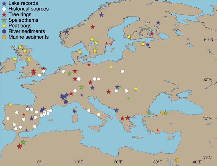
Figure 1: The Euro-Med2k multi-proxy network for hydrological reconstructions. Small, unframed symbols refer to archives for which only metadata exist. Documentary evidence represents larger data assemblages. |
As another outcome of this workshop, Euro-Med2k expressed strong willingness to maintain its current form and structure beyond 2016. This vision is grounded on a variety of scientific challenges and opportunities associated with the still-growing database.
In addition to the reconstruction of European summer temperatures since Roman times (Luterbacher et al. 2016), Euro-Med2k expanded its perspective towards hydroclimate and compared environmental changes with societal reorganizations.
Ljungqvist et al. (2016) compiled and analyzed 196 moisture-sensitive records to place recent hydrological changes and future precipitation scenarios in a long-term context. They found persistent seesaw patterns of alternating moisture regimes operating throughout the past 12 centuries. Together with an updated compilation of 128 temperature proxy records, the relationship between the reconstructed centennial-scale NH climate variability was assessed and compared to model simulations. While they show reasonable agreement during pre-industrial times, the intensification of the 20th century mean hydroclimatic anomalies in the model simulations, as compared to previous centuries, is not supported by the new multi-proxy reconstruction.
Büntgen et al. (2016) used tree-ring chronologies from the Russian Altai and European Alps to reconstruct summer temperatures over the past two millennia. Unprecedented, long-lasting and spatially synchronized cooling was detected after a cluster of large volcanic eruptions in 536, 540 and 547 CE. This sharp drop in summer temperatures was likely sustained by ocean and sea-ice feedbacks, superimposed on a solar minimum. The interval from 536 to ~660 CE was termed the Late Antique Little Ice Age (LALIA), and should be considered as an additional environmental factor contributing to the establishment of the Justinian plague, transformation of the eastern Roman Empire and collapse of the Sasanian Empire, movements out of the Asian steppe and Arabian Peninsula, spread of Slavic-speaking people and political upheavals in China.
Büntgen and Di Cosmo (2016) enhanced our perception of the environmental conditions under which historical events may have occurred. The sudden withdrawal of the Mongols from Hungary in 1242 CE has generated an array of controversial theories. None of them, however, combined historical reports and natural archives. Documentary sources and tree-ring chronologies reveal warm and dry summers from 1238-1241, followed by cold and wet conditions in 1242. Marshy terrain across the Hungarian plain probably reduced pastureland and decreased mobility, as well as the military effectiveness of the Mongol cavalry, while local despoliation and depopulation caused famine. These circumstances arguably contributed to the determination of the Mongols to abandon Hungary and return to Russia. While overcoming deterministic and reductionist arguments, the new “environmental hypothesis” emphasizes the importance of minor climatic fluctuations on major historical events.
affiliationS
1Swiss Federal Research Institute for Forest Snow and Landscape, Birmensdorf, Switzerland
2Oeschger Centre for Climate Change Research, University of Bern, Switzerland
3Global Change Research Centre, Brno, Czech Republic
4Department of History, Stockholm University, Sweden
5Bolin Centre for Climate Research, Stockholm University, Sweden
6Department of Geography, Johannes Gutenberg University, Mainz, Germany
7Department of Geography and Centre for International Development and Environmental Research, Justus-Liebig-University Giessen, Germany
8Institute for Coastal Research, Helmholtz Centrum, Geesthacht, Germany
9Bjerknes Centre for Climate Research and Department of Earth Science, University of Bergen, Norway
10List of all workshop participants and group picture here: www.pastglobalchanges.org/calendar/all-events/127-pages/1578-euromed-consolid-meet
contact
Ulf Büntgen: buentgenwsl.ch
references
Büntgen U et al. (2016) Nature Geosci 9: 231-236
Büntgen U, Di Cosmo N (2016) Sci Rep 6, doi:10.1038/srep25606
Charpentier Ljungqvist FC et al. (2016) Nature 532: 94-98
Luterbacher J et al. (2016) Environ Res Lett 11, doi:10.1088/1748-9326/11/2/024001
Helen V. McGregor1, B. Martrat2,3, M.N. Evans4, D. Thompson5, D. Reynolds6, J. Addison7 and Workshop Participants8
1st Ocean2k workshop, Barcelona, Spain, 6-8 October 2015
The oceans make up 71% of the Earth’s surface area and are a major component of the global climate system. They are the world’s primary heat reservoir, and knowledge of the global ocean response to past and present radiative forcing is important for understanding climate change. PAGES’ Ocean2k working group aims to place marine climate of the past century within the context of the previous 2000 years (2k). Phase 1 (2011-2015) focused on constraining the forcing mechanisms most consistent with reconstructed sea surface temperature (SST) over the 2k interval (McGregor et al. 2015; Tierney et al. 2015). The 1st Ocean2k workshop assisted in the transition to Ocean2k Phase 2 (2015-2017), with the workshop goal to develop, coordinate and significantly advance community-identified and -driven activities.
A novel pre-workshop proposal process generated over a dozen ideas for Phase 2, which were then refined at the three-day workshop to three themes of broad interest to the Ocean2k community: metadatabase modernization, quantifying and reducing marine record age model uncertainties, and understanding patterns of global ocean δ18O. In addition, a series of sub-themes with distinct foci emerged.
Metadatabase modernization
Expanding on the crowd-sourced development of the Ocean2k metadatabase (www.pastglobalchanges.org/ini/wg/ocean2k/data), this theme will facilitate submission of datasets to public archives and integrate the metadatabase with the LiPD (McKay and Emile-Geay 2016) and SESAR/EarthChem initiatives (http://earthcube.org/group/marine-annually-resolved-proxy-archives). These initiatives will advance synthesis activities within Ocean2k, PAGES 2k working groups, and with scientists globally.
Age model uncertainties
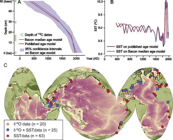 |
|
Figure 1: (A) Age-depth relationship for marine core MC-29D from the original publication (linear interpolation between dates, red line; Keigwin et al. 2003), and recalculated (blue line) using the Bacon software (Blaauw and Christen 2011). Age models are based on 14C dates only. (B) MC-29D alkenone SST record plotted against the age models from (A). Age models differ by up to 85 years. (C) Marine sediment core δ18O and SST reconstructions in the Ocean2k metadatabase, October 2015 version. |
This theme will apply uniform age model calibration techniques to records in the Ocean2k network, and re-examine their age uncertainties to improve the description of marine climate patterns in space and time through the 2k interval. Preliminary analysis suggests that different techniques can result in age model shifts of ±85 years (4.25% age uncertainty; Fig. 1a-b), making it difficult to identify multi-decadal variability in the marine realm. But, at the centennial scale, a standardized 14C calibration methodology could better constrain the timing of common spatial variability and reduce temporal uncertainty estimates.
Ocean δ18O
Ocean2k Phase 1 identified numerous individual coral and foraminifera SST reconstructions covering some or all of the past 2k, and many of these have associated δ18O measurements (Fig. 1c). The ocean δ18O theme will bring these marine SST and δ18O records together to document the first order spatio-temporal patterns of global ocean δ18O and investigate the ocean hydroclimate, salinity signals, and circulation changes of the past 2000 years. Results will be compared with realistically forced simulation (isotope-enabled where possible) and the theme will run in conjunction with the PAGES 2k trans-regional project Iso2k.
Additional themes
Additional sub-themes will explore the ENSO and teleconnection signals identified in the Phase 1 analysis (Tierney et al. 2015); investigate spatio-temporal AMOC dynamics; synthesize Mediterranean Sea records to investigate North Atlantic influences on the Mediterranean climate for the Little Ice Age and Medieval Climate Anomaly; and evaluate the oceanic response to volcanic forcing seen in proxy and model reconstructions with simulated post-eruption climate features.
Join us
The workshop was the first in-person meeting of the Ocean2k working group after over four years of productive, consensus-driven collaboration (Evans 2015), and we invite you to join the project. See www.pastglobalchanges.org/ini/wg/ocean2k/intro for additional information, or please contact the new overall lead of the working group, Helen McGregor. We thank the CosmoCaixa Natural Science Museum for hosting us and facilitating our successful outreach event, attended by over 100 high school students.
affiliationS
1School of Earth and Environmental Sciences, University of Wollongong, Australia
2Department of Environmental Chemistry, Spanish Council for Scientific Research, Barcelona, Spain
3Department of Earth Sciences, University of Cambridge, UK
4Department of Geology and Earth System Science Interdisciplinary Center, University of Maryland, College Park, USA
5National Center for Atmospheric Research, Boulder, USA
6School of Earth and Ocean Sciences, Cardiff University, UK
7U.S. Geological Survey, Menlo Park, USA
8In-person and virtual, www.ocean2k-bcn2015.org/contributions/participants
contact
Helen McGregor: mcgregoruow.edu.au
references
Blaauw M, Christen JA (2011) Bayesian Anal 6: 457-474
Evans MN (2015) "Virtually" Ocean2k, Future Earth
Keigwin LD et al. (2003) Clim Dyn 21: 53-62
McGregor HV et al. (2015) Nature Geosci 8: 671-677
McKay NP, Emile-Geay J (2016) Clim Past 12: 1093-1100
Tierney JE et al. (2015) Paleoceanography 30: 226-252
Jason E. Smerdon1, J. Luterbacher2 and S.J. Phipps3
Palisades, USA, 1-3 June 2016
New paleoclimate reconstructions are expanding insights into hydroclimate variability and change during the Common Era (e.g. Cook et al. 2015; Diaz and Wahl 2015). Many last-millennium simulations using fully-coupled climate models are also becoming available (e.g. Fernandez-Donado et al. 2013). Importantly, Phase 3 of the Paleoclimate Modelling Intercomparison Project (PMIP3) included a last-millennium experiment in its protocol, and multiple centers performed the experiment using the same state-of-the-art models used for Phase 5 of the Coupled Model Intercomparison Project (CMIP5). Ensembles of last-millennium simulations (e.g. Otto-Bliesner et al. 2016) are also proposed as part of PMIP4. These developments make the time ripe for expanding our understanding of past hydroclimate variability, while exploring whether climate models simulate hydroclimate in ways that are consistent with the paleoclimate record.
Addressing these emerging themes was the focus of a workshop titled Comparing data and model estimates of hydroclimate variability and change over the Common Era, organized jointly by PAGES 2k and the PAST2k working group of PMIP (see Schmidt et al. 2014 and PAGES 2k-PMIP3 group 2015 for outcomes of related past workshops). The workshop included presentations from paleoclimatologists on hydroclimate proxies and their interpretation, climate modelers on current efforts to simulate climate over the Common Era, and from researchers working at the interface of these two areas (see the full agenda and presentation slides at: http://pages2kpmip3.github.io/). The presentations and associated discussions provided an assessment of the state of the science, the challenges associated with hydroclimate comparisons between proxy information and model simulations, and an evaluation of best practices in this emerging field.
 |
|
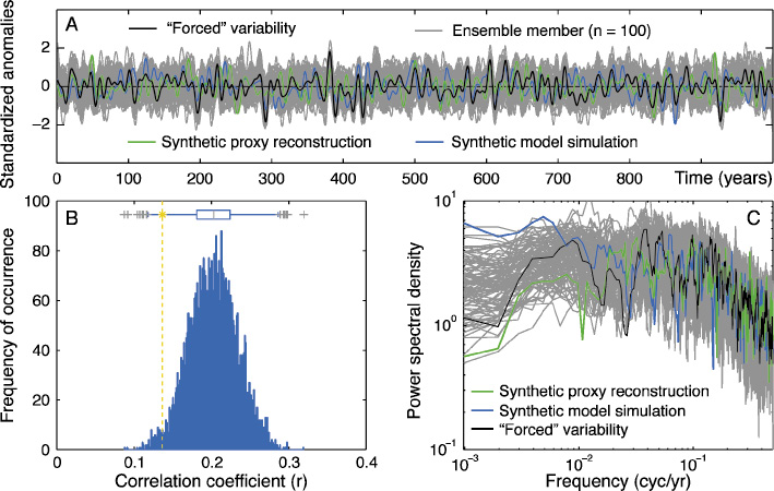
Figure 1: (A) A “forced” signal modeled as an autoregressive lag-1 process (AR(1); μ = 0, σ = 1, ρ = 0.3) and 100 synthetic climate histories constructed by adding the forced series to 100 AR(1) series (μ = 0, σ = 2, ρ = 0.3) to represent internal variability. Two of the ensemble members are highlighted to represent a proxy record and a model simulation that both perfectly sample the forced climate variability while having different realizations of internal variability. All plotted series have been processed with a 10-year lowpass filter. (B) The distribution of Pearson’s correlation coefficients calculated between each of the grey series in panel (A). The boxplot shows the median, interquartile range and the outliers in grey crosses. The yellow dashed line and star indicate the correlation coefficient calculated between the unfiltered proxy and model series in panel (A). (C) The multitaper power spectral density estimates for the forced series and all grey series shown in panel (A). |
Workshop discussions underscored the nascent stage of data-model comparisons over the Common Era generally, and specifically with regard to hydroclimate. Recommendations include the need to account for internal variability and its influence on comparison outcomes. Internal variability will obscure comparisons between proxy reconstructions and climate model simulations, even if they represent both forced changes and internal variability perfectly (Fig. 1). Analyses that go beyond simple time-series associations are therefore strongly advocated, including bootstrapping exercises to evaluate null hypotheses and assessments based on spectral information. The importance of proxy system models (PSMs) was also stressed. When studying decadal and centennial variability, PSMs allow better accounting of the reddening of climatic signals present in some proxy records. For the emerging area of paleoclimate data-assimilation, PSMs also account for the multiple environmental variables often integrated by proxies. Generally, comparison efforts should include as many models as possible, while incorporating the collection of ensemble simulations from individual models. Spatial sampling should be done carefully, keeping in mind that local associations do not necessarily scale regionally or globally (and vice versa). These general points of guidance and the emerging efforts to refine techniques for hydroclimate data-model comparisons will further enhance our ability to evaluate climate models, understand the dynamics of hydroclimate variability and change, and constrain our characterizations of climate risks in the future.
Acknowledgements
This workshop was made possible by PAGES and the Climate Center at the Lamont-Doherty Earth Observatory.
affiliationS
1Lamont-Doherty Earth Observatory of Columbia University, Palisades, USA
2Department of Geography and Centre for International Development and Environmental Research, Justus-Liebig-University Giessen, Germany
3Institute for Marine and Antarctic Studies, University of Tasmania, Hobart, Australia
contact
Jason Smerdon: jsmerdonldeo.columbia.edu
references
PAGES 2k-PMIP3 group (2015) Clim Past 11: 1673-1699
Cook ER et al. (2015) Sci Adv 1, doi:10.1126/sciadv.1500561
Diaz HF, Wahl ER (2015) J Clim 28: 4637-4652
Fernandez-Donado L et al. (2013) Clim Past 9: 393-421
Otto-Bliesner BL et al. (2016) BAMS 97: 735-754
Schmidt GA et al. (2014) Clim Past 10: 221-250
Fabien Arnaud1, J. Dearing2, P. Gell3, K. Walsh4 and D. Penny5
Chambéry, France, 30 May - 1 June 2016
Paleosciences played a crucial role in the societal acknowledgement of humankind’s responsibility for global warming. However, while the Earth is simultaneously facing its sixth mass extinction, mainly triggered by human activities and a dramatic rise in human population, it appears more and more obvious that climate is not the sole human-modified system whose dysfunction threatens the security and well-being of humans. Biodiversity loss, soil degradation, the spreading of contaminants, and disturbed nutrient cycles are of particular concern (Steffen et al. 2015). The long-term dynamics of those threats to ecosystems, as well as their impact on ecosystem services, remain largely unknown.
Understanding the complex long-term interactions between human actions, climate and the functioning of social-ecological systems is critical to prepare a safe future (Costanza et al. 2007; Dearing et al. 2015). Addressing these interactions also contributes to the Future Earth Vision 2025 call for new integrated scientific approaches to better understand the complex dynamics of social-ecological systems. In this context, this workshop investigated the potential of paleosciences to create knowledge to help increase the sustainability of human development on Earth.
Scientific contributions and discussions
 |
|
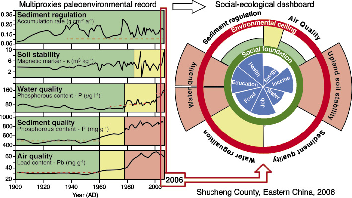
Figure 1: Combination of paleoecological proxies to propose an evaluation of ecosystem functioning and threats of a given region, taking account of its social-ecological trajectories - here for Shuncheng County, China (modified from Dearing et al. 2014). Such an approach combines the concepts of paleo-ecosystem services (Dearing et al. 2012) and safe operating space for humanity (Raworth 2012; Rockström et al. 2009). |
The workshop was split into three parts with the aim of answering the questions: (1) why, (2) what kind and (3) how to integrate paleodata to better understand complex human-climate-environment interactions? Based on case studies, conceptual advancements were presented. In particular, the attendees debated the interest of transposing the concepts of “safe operating space” and “ecosystem services” to paleostudies. Those concepts could indeed permit the description of the evolution of the environment from a societal point of view with a limited number of descriptors. This point appeared crucial, considering the great diversity of reconstructed variables. Such an approach could provide the foundation for the integration of various proxies from a large variety of disciplines (Fig. 1).
Among the innovative proxies of past changes, DNA and chemical biomarkers appear particularly promising. The integration of archeological and paleoenvironmental data to explain civilization collapses or landscape shaping is of particular interest, but better information systems that combine both the spatial and temporal aspects still need to be developed. Finally, while the ability of models to depict societal-environmental dynamics is getting better, they are still rarely used. Especially at a regional scale, models could be used to connect the local contribution of human practices to global changes and human vulnerability.
Working group perspective
The workshop assembled a new scientific community and generated fruitful and novel discussions. Attendees agreed to submit a proposal for the creation of a new PAGES working group titled “Social-environmental trajectories”. The aim of this group would be to promote the development of a scientific community located at the junction of the paleo-, ecological- and human sciences. Based both on proxy reconstructions and ecosystem services-oriented modeling, this group seeks to understand how human practices in the past were successful in the face of global changes over long time periods. Hence the group would ultimately question the resilience of today’s societies in the face of global changes, with respect to cultural and natural heritage in particular.
affiliationS
1Environment Dynamics and Territories of Mountains (CNRS), University Savoie Mont Blanc, Chambéry, France
2Palaeoecology Laboratory, Geography and Environment, University of Southampton, UK
3Water Research Network, Federation University, Ballarat, Australia
4Department of Archaeology, University of York, UK
5Faculty of science, University of Sydney, Australia
contact
Fabien Arnaud: fabien.arnauduniv-smb.fr
references
Costanza R et al. (2007) Ambio 36: 522-527
Dearing JA et al. (2015) Anthrop Rev 2: 220-246
Dearing JA et al. (2014) Glob Environ Change 28: 227-238
Dearing JA et al. (2012) PNAS 109: E1111-E1120
Raworth K (2012) A Safe and Just Space for Humanity, Oxfam Discuss Pap
Julien Emile-Geay1 and Nicholas P. McKay2
Boulder, USA, 22-23 June 2016
The progress of science can be directly tied to increased standardization of measurements, instruments, and information. Hosted by the US National Centers for Environmental Information (NOAA-NCEI) World Data Service for Paleoclimatology (WDS-Paleo)1 in Boulder, USA, 40 participants gathered to establish preliminary standards for paleoclimate data. The workshop was primarily supported by the EarthCube-funded LinkedEarth project2, with auxiliary support from PAGES to ensure international participation.
A common tongue
 |
|
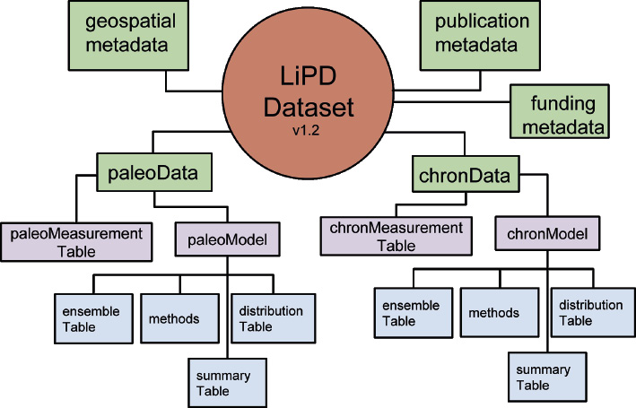
Figure 1: Data and metadata compartments in the current version of LiPD. The format is designed to store, along with several kinds of metadata (location, publication, funding), data tables pertaining to the paleosystem of interest (most often, climate), as well as chronology data, including raw chronological tie points and models based on them. |
Building upon the machine-readable Linked Paleo Data framework (LiPD; McKay and Emile-Geay 2016; Fig. 1), the group recognized the need for (i) a structure to organize data and metadata and (ii) a consensual terminology. Group activities highlighted the difficulty to agree upon such terminology, though the conceptualization of Evans et al (2013) emerged as a sound foundation for the structure. WDS-Paleo presented efforts to normalize the terminology used to report observations and their units, for each archive type3.
Shades of metadata
While more metadata are always desirable, a key discussion focused on distinguishing a set of essential, recommended and optional properties for each dataset. A consensus emerged that these levels are archive-specific (e.g. what is essential to intelligently re-use a dataset is different for a speleothem and a marine sedimentary record). Therefore, the community should coalesce around archive-specific working groups to propose such recommendations. The group also recognized the asymmetry between modern and legacy records (metadata for the latter being inherently more difficult to gather), so what counts as “essential” will be different depending on the age of the study.
A cornerstone of group discussions was to identify what metadata allow to reproduce, cite, and reuse, paleoclimate data. Rewarding data producers emerged as a central theme, thanks in part by presentations on connected efforts on data citations4, links to scientific expeditions5, and physical samples6. The difficulty to mint data digital object identifiers with the appropriate level of granularity, as well as the current cap on the number of citations in mainstream science journals, were recognized as a major hurdle to crediting data producers; a dialogue with the publishing community should be initiated to remove these hurdles.
Characterizing data records
Part of the drive to enhance the description of paleoclimate data is the need to better communicate their inherent uncertainties. The indirect nature of paleoclimate observations also requires a precise language for their interpretation. This motivated a discussion of a formal paleoclimate ontology, a preliminary version of which was unveiled7. Ontologies are formal representations of concepts and their logical connections, and their dividends in other fields were presented. Despite their scientific importance, the concepts of uncertainty and interpretation were found difficult to define unambiguously. However, the group underscored the importance of quantifying how completely these notions are described in the metadata. A multivariate completeness score was proposed8, allowing users to rapidly evaluate metadata completeness along several dimensions, thus incentivizing best curation practices.
Building consensus
Standards arise by consensus. The group acknowledged the necessity to engage a broad community of paleoscientists, and establish a mechanism to gather their input. The LinkedEarth wiki9 was designed to facilitate initial discussions by communities of interest, and elaborate recommendations addressing the various issues raised at the workshop. The community engagement process is described at http://linked.earth/community-standards-development/. PAGES will play a key role in this feedback elicitation, and anyone interested in the process should reach out to linkedearthgmail.com. An official communication from the PAGES IPO about the role of this process in the PAGES Data Stewardship10 Initiative is forthcoming.
affiliationS
1Climate Dynamics Lab, University of Southern California, Los Angeles, USA
2School of Earth Sciences and Environmental Sustainability, Northern Arizona University, Flagstaff, USA
contact
Julien Emile-Geay: linkedearthgmail.com
links
1www.ncdc.noaa.gov/data-access/paleoclimatology-data; 2http://linked.earth; 3https://agu.confex.com/agu/fm15/webprogram/Paper65476.html; 4www.datacite.org; 5www.geolink.org; 6www.geosamples.org; 7http://vowl.visualdataweb.org/webvowl/#iri=http://linked.earth/ontology; 8http://wiki.linked.earth/WG_completeness; 9http://wiki.linked.earth; 10www.pastglobalchanges.org/ini/int-act/data-stewardship
references
Thomas Giesecke1, J.-L. de Beaulieu2 and M. Leydet-Barbier2
Aix-en-Provence, France, 1-3 June 2016
Open-access paleo databases are of the utmost importance to arrive at a regional, continental, or global understanding of long-term processes and investigate past dynamics of Earth systems. The European Pollen Database (EPD), created alongside the North American Pollen Database more than 25 years ago, serves as the base for numerous analyses of climate, vegetation and land-cover change, while also being an important data repository and educational tool (Fyfe et al. 2009). To function as an up-to-date research tool, the database requires both the submission of new pollen data from the community as well as data stewardship and development of the database. The database is a community-wide effort, but there is an inherent risk of a division between data producers and data users. To overcome this separation and to generate new momentum in the development of the database, we called for an open EPD meeting and training workshop. Co-funded by PAGES, it attracted 126 paleoecologists, at all career stages, from 24 countries.
The meeting consisted of plenary lectures, training workshops, and group and plenary discussions. The lectures illustrated different research fields that use the database, such as climate and land-cover reconstructions (J. Guiot and M.-J. Gaillard), archeology (R. Fyfe), last glacial vegetation change (M. F. Sanchez Goñi), nature conservation (R. Bradshaw), and the postglacial spread of plants (T. Giesecke). Lectures also addressed interactions with the Global Charcoal Database (B. Vannière & D. Colombaroli), problems developing age models beyond the radiocarbon timescale (C. Tzedakis), and the new database infrastructure Neotoma (E. Grimm).
 |
|
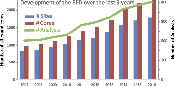
Figure 1: Development of the European Pollen Database since the open meeting in 2007. The number of sites and cores has doubled over the last nine years. |
Seven parallel training workshops introduced participants to numerical problems in paleodata analyses and representation: (i) the data management and graphing software Tilia and its interaction with Neotoma (E. Grimm); (ii) the use of the modern surface sample dataset in quantitative reconstructions (B. Davis & M. Zanon); (iii) quantitative vegetation reconstructions using the Landscape Reconstruction Algorithm (P. Kuneš & M. Theuerkauf); (iv) charcoal software and database (B. Vannière & W. Finsinger); (v) working with the EPD using the data analysis software “R” (A. Seddon & J. Chipperfield); and (vi) age modeling (T. Giesecke). Another workshop was dedicated to the identification of non-pollen-palynomorphs (B. Dietre & S. Wolters), which is a field of active development in Quaternary palynology. All workshops were well received by participants, who wished they could be organized on a regular basis.
Group and plenary discussions focused on how to improve the database and make it more accessible to other communities, and we reviewed and simplified the rules and regulations. We also reviewed and reorganized the following EPD working groups:
The Taxonomy working group, coordinated by Steffen Wolters, keeps track of synonym names in the database and is developing a hierarchical system based on morphology. Future activities will include non-pollen-palynomorphs.
The Chronologies working group has produced standardized age models for over 800 sites (Giesecke et al. 2014). Coordinated by Thomas Giesecke, the group aims to provide the same type of models in addition to bayesian age models for the recently submitted sites.
Coordinated by Basil Davis, the Surface Samples working group, which compiled a new European dataset of surface sample data (Davis et al. 2013), will work on expanding this dataset.
The group on Community Outreach is now coordinated by Graciela Gil-Romera. This group will use social media to improve visibility, prepare educational packages for the general public and organize training workshops for the EPD community.
The new Quantitative Tools working group, coordinated by Alistair Seddon, was formed to focus on R and GIS applications. Plus, Petr Kuneš heads up another new group, Former Interglacials, which aims to organize and promote datasets that go beyond the radiocarbon time scale.
Be involved! For further news and information on how to contribute, go to: www.europeanpollendatabase.net
affiliationS
1Department of Palynology and Climate Dynamics, University of Göttingen, Germany
2Institut Méditerranéen de Biodiversité et d’Ecologie marine et continentale, Aix-Marseille Université, Aix-en-Provence, France
contact
Thomas Giesecke: thomas.gieseckebiologie.uni-goettingen.de
references
Davis BAS et al. (2013) Veget Hist Archaeobot 22: 521-530