PAGES Magazine articles
Jed O. Kaplan
ARVE Group, Swiss Federal Institute of Technology Lausanne, Switzerland; jed.kaplan epfl.ch
During the 12,000 years preceding the Industrial Revolution, melting ice sheets, stabilizing sea level, and changes in temperature and precipitation patterns influenced global land cover. Over the same period, humans adopted agriculture, domesticated animals, developed metallurgy and other technologies, and evolved in their social and cultural systems. These changes led to exponential growth in human populations, urbanization, and the expansion of human settlements to the entire ice-free area of the world. Both human-induced and natural environmental change over the Holocene resulted in the transformation of the Earth’s system by modifying land cover and through emissions of greenhouse gases and aerosols.
Preindustrial anthropogenic activities, mainly deforestation, rice cultivation, and domestication of ruminants, resulted in substantial emissions of CO2 and CH4 to the atmosphere. This change in greenhouse gas concentrations could have affected global climate to the point of precluding the inception of a new glacial period (Ruddiman 2003; Ruddiman et al. 2011). Ruddiman based his analysis on orbital forcing, thought to be the ultimate cause of ice age inception, and atmospheric CO2 and CH4 concentrations measured in ice cores. He concluded that greenhouse gas concentrations in the Holocene showed anomalous trends when compared to previous interglacials. Ruddiman’s analysis has been criticized on the alignment between orbital forcing and greenhouse gas records, and because most previous interglacials show a time trend in orbital forcing that is not completely analogous to the Holocene. There is one undisputed feature of the Holocene, however, that we know makes this epoch different from the rest of Earth history: the existence of behaviorally modern humans.
The earliest significant impact humans probably had on large-scale land cover is the application of fire for the improvement of hunting and gathering opportunities. Even extremely low population densities can radically change land cover using fire (Bowman 1998; McWethy et al. 2009). Where an obvious anthropogenic trend is not identified in synthesis of charcoal records from sedimentary archives (Marlon et al. 2008) this may be a result of the fact that we have no appropriate baseline without human influence with which to assess the data, e.g. from previous interglacials.
 |
|
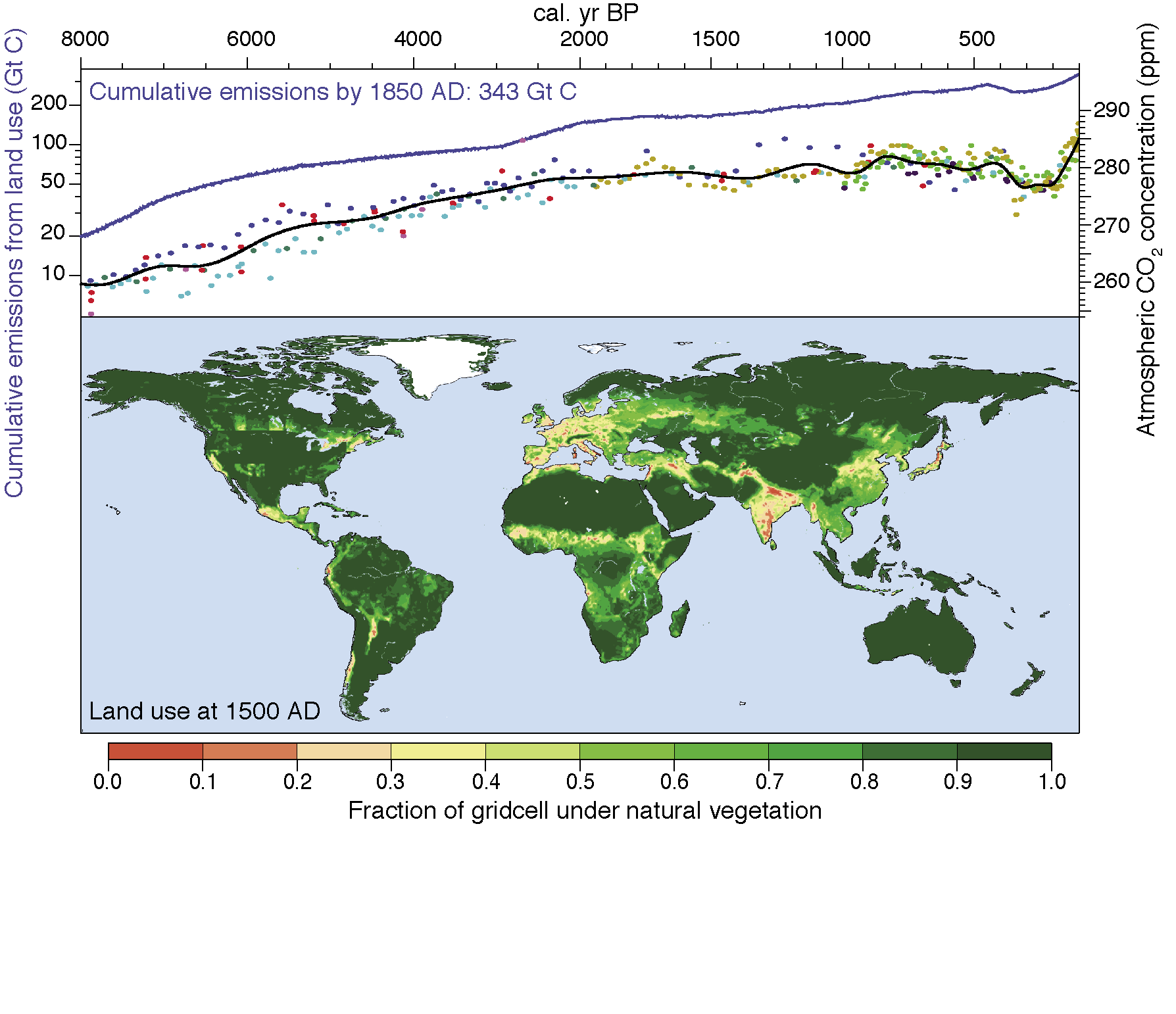
Figure 1: Top: Preindustrial Holocene atmospheric CO2 concentrations measured in Antarctic ice cores (dots, black line), and carbon emissions as a result of anthropogenic land cover change (blue line). Bottom: Global land use at 1500 AD, before the collapse of the indigenous populations of the Americas following European contact. For details and data sources, see Kaplan et al. 2011. |
With the Neolithic revolution, the human interaction with the landscape changed completely, with large areas of natural vegetation converted to cropland and pasture. Outside of river floodplains, early agriculture was inefficient, and meant that early farmers used much more land per capita than observed even in late preindustrial societies. Deforestation for agricultural land use and exploitation of forest resources for fuel, construction materials, and nutrients meant that human impact on the global carbon cycle could have been substantial (Fig. 1; Kaplan et al. 2011). Furthermore, beginning in the mid-Holocene, the spread of wet rice cultivation in Asia (Fuller et al. 2011) and the production of charcoal for metal smelting would have led to large increases in CH4 emissions over natural levels. Thus, anthropogenic activities could have caused the increases in atmospheric CO2 and CH4 concentrations observed over the last 6 ka.
While anthropogenic activities may have stabilized or increased greenhouse gas concentrations leading to a warmer global climate than would have occurred otherwise, the biogeophysical impact of deforestation and increases in aerosols could have had contrasting effects. Cooling could have occurred as a result of increased surface and atmospheric albedo, though climate-modeling experiments have shown that these effects are limited to the region where land cover change occurred. Furthermore, preindustrial human activities affected the global hydrological balance: deforestation leads to reductions in evapotranspiration and increases in runoff; these alterations could also have led to seasonally contrasting changes in regional climate. Anthropogenic activities probably had an influence on regional and global climate over the Holocene, long before the Industrial Revolution.
selected references
Full reference list online under: http://pastglobalchanges.org/products/newsletters/ref2012_1.pdf
Fuller DQ et al. (2011) The Holocene 21(5): 743-759
Kaplan JO et al. (2011) The Holocene 21(5): 775-791
McWethy DB et al. (2010) PNAS 107(50): 21343-21348
Marlon JR et al. (2008) Nature Geoscience 1: 697-702
Ruddiman WF, Kutzbach JE and Vavrus SJ (2011) The Holocene 21(5): 865-879
Anthony L. Westerling
Sierra Nevada Research Institute, University of California, Merced, USA; awesterlingucmerced.edu
Large wildfires in a diverse array of forests are typically associated with drought during the fire season (Krawchuk and Moritz 2011). Drought occurrence is driven by variability in both temperature and precipitation. Climate change is expected to increase temperature over land, with greater increases in continental interiors and high northern latitudes. However, precipitation is more varied and uncertain, with increases projected in the tropics and high latitudes, and decreases in mid-latitudes (Dai 2010). Warming combined with changes in precipitation is projected to produce permanent severe drought conditions by mid-to-late century for much of the Americas, Africa, Southern Europe, Central and Southeast Asia, and Australia, although uncertainty is high (Dai 2010). Changes of this magnitude could substantially alter ecosystems, with wildfire constituting a mechanism effecting abrupt changes in response to more gradual climate forcings. The lack of analogues for transitions of this speed and magnitude limit the capacity to robustly model climate-fire-vegetation interactions in coming decades.
 |
|
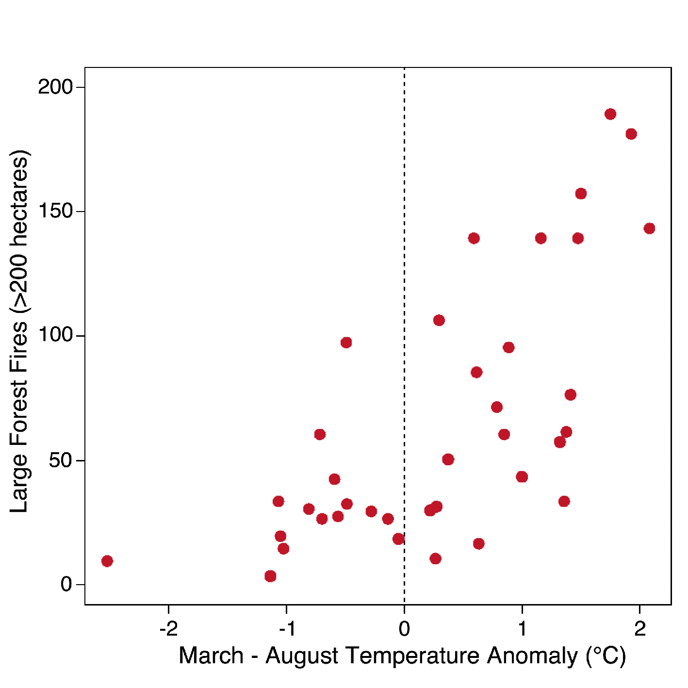
Figure 1: The number of large forest wildfires (vertical axis) versus average March through August temperature anomalies (horizontal axis) for 1972-2008 in Western US forests. Anomalies were constructed subtracting the long-term mean for 1972-1990. Fires are all large (> 200 ha) fires reported by the United States’ Bureau of Indian Affairs, National Park Service, and Forest Service as burning in forests. All fires were classified as “action” fires on which suppression was attempted (fires used to manage vegetation were excluded). See Westerling et al. 2006 and Westerling et al 2011 for data and methodology. |
Ecosystems highly sensitive to recent climate trends include cool, moist forests with infrequent, stand-replacing fire where warming has led to longer fire seasons and/or increased evapotranspiration. Examples include substantially increased fire in mid-elevation Rocky Mountain forests of the USA (Westerling et al. 2006) and Canadian and Alaskan boreal forests (Soja et al. 2007) (Fig. 1). High-severity burned area in Siberian boreal forests may also have increased, but historical baseline data are less reliable (Soja et al. 2007). Fire is likely to further increase in these forests with continued warming (e.g. Krawchuk et al. 2009; Wotton et al. 2010; Westerling et al. 2011). However, as climate shifts and fire becomes more frequent, changes in regeneration and productivity for forest species could transform vegetation assemblages and the fire regimes they can support (Soja et al. 2007; Krawchuk et al. 2009; Westerling et al. 2011). An additional uncertainty for these ecosystems is how fire may interact with other disturbance types such as bark beetle outbreaks that alter the structure of forest fuels.
Dry, warm forests may still be sensitive to warming that exacerbates periodic drought. Large areas burned in conjunction with recent drought and warming in mountain forests of the southwestern United States (Williams et al. 2010). The largest fires there coincided with reduced precipitation, higher temperatures and earlier spring snowmelt (Westerling et al. 2006). Land use and fire suppression in southwestern forests also led to fuel accumulation and changes in fuel structure. The interaction of fuel changes with climate change and variability likely contributed to increased fire and fire severity, but the relative importance of these causes is not known (Williams et al. 2010). Recurrent severe drought could convert large portions (>50%) of Southwestern U.S. forests to non-forest vegetation due to fire, beetles and other climate-related dieoff (Williams et al. 2010), substantially altering fire regimes.
As in higher latitude forests, drought-driven increases in fuel flammability drive increased fire in tropical forests. However, short-term reductions in precipitation, rather than elevated temperatures, are the dominant influence on wildfire in tropical forests due to their higher temperatures (Goldammer and Price 1998). While on average increased aridity is projected for Amazon, Mexico and Congo forests across many climate models, the greater uncertainty associated with projected patterns of precipitation make future fire predictions in these tropical forests more uncertain as well.
Diverse forests in many regions of the globe have the potential for increased fire in the coming decades due to changes in temperature, precipitation or both. Changes in climate and disturbance may substantially alter vegetation in ways that feed back to or limit changes in forest wildfire.
selected references
Full reference list online under: http://pastglobalchanges.org/products/newsletters/ref2012_1.pdf
Dai A (2011) Wiley Interdisciplinary Reviews: Climate Change, 2(1): 45-65
Krawchuk M and Moritz M (2011) Ecology 92(1): 121-132
Soja A et al. (2007) Global and Planetary Change 56: 274-29
Sandy P. Harrison1 and Patrick J. Bartlein2
1School of Biological Sciences, Macquarie University, North Ryde, Australia; sandy.harrisonmq.edu.au
2Department of Geography, University of Oregon, Eugene, USA
 |
|
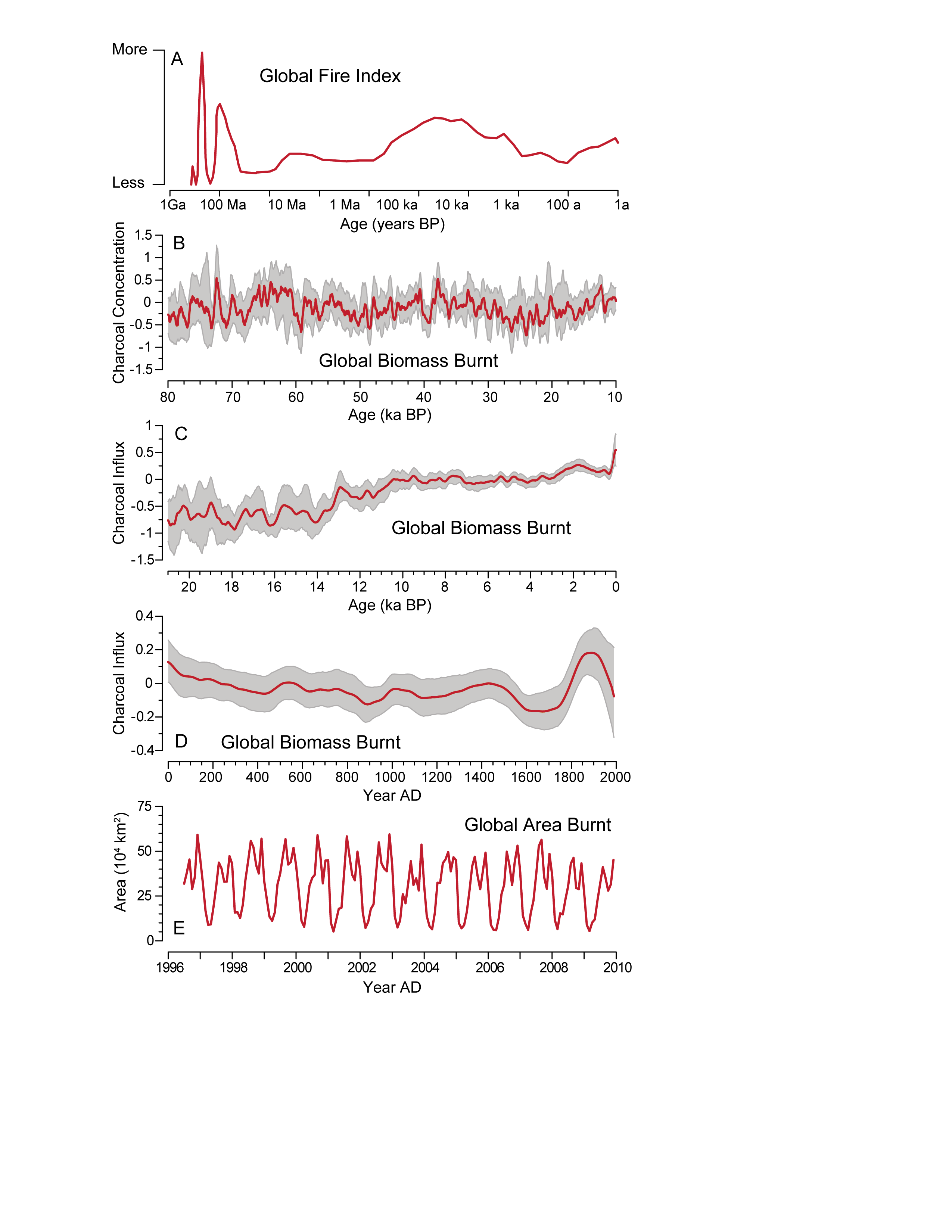
Figure 1: The incidence of wildfire varies on multiple timescales. The record for the past billion years (1 Ga) (A) is a qualitative index of global fire based on discontinuous sedimentary charcoal records (Bowman et al. 2009). The record for the past 80 ka (B) is a global composite of 30 sedimentary charcoal records (Daniau et al. 2010a), that for the past 21 ka (C) is a global composite of ca. 700 sedimentary charcoal records (Daniau et al., unpublished data) and that for the past 2 ka is a global composite of ca. 400 sedimentary charcoal records (D; Marlon et al. 2008). The biomass burnt record in B, C and D is expressed as z-score anomalies from a long-term mean. Global area burnt from 1997 to 2009 (E) is derived from satellite-based remote sensing (GFED v3.1; Giglio et al. 2010). |
Wildfire, the most widespread form of vegetation disturbance, has multiple influences on climate, and places an increasingly large socio-economic burden on society. Remote-sensing and historical records provide insights into how climatic, environmental and human factors influence the incidence of wildfire. These sources only cover the last few decades – a period when climate variations were much smaller than the changes expected during the 21st century and, globally, there were no radical changes in human activities. Luckily, there are other sources of information about changes in regional wildfire regimes in response to both large climatic changes and fundamental shifts in human activities. These sources include measurements of the isotopic composition of atmospheric gases trapped in ice cores, fire scars on living and fossil trees, and biomarkers and charcoal preserved in sediments. Of these, the most abundant are sedimentary charcoal: there are well over 800 site records worldwide, some providing high-resolution data for the last few millennia and some records spanning several glacial-interglacial cycles (Fig. 1).
Globally, fire is low during cold, glacial intervals and high during warm, interglacial intervals (Daniau et al. 2010a). The incidence of fire tracks the shift in global temperature during the last deglaciation (Power et al. 2008). It also tracks the rapid temperature changes (Dansgaard-Oeschger cycles) during the last glaciation with a lag of <50-100 years (Daniau et al. 2010a; Mooney et al. 2011). On centennial to multi-millennial time-scales and regional to global space-scales, temperature is the major driver of changes in biomass burning: increasing temperature leads to increased fire through increasing plant productivity and hence fuel production (Daniau et al., unpublished data). The effect of precipitation change is more complex. Fire peaks at intermediate precipitation levels at all temperatures: fire is low in dry environments because of lack of fuel and in wet environments because the fuel is too damp to burn. The impact of a precipitation change will depend on whether a site lies in a dry “fuel-limited” or a wet “drought-limited” environment. These climate-fire relationships are not unique to the paleorecord: similar relationships are found in global analyses of remotely sensed burnt area (Daniau et al., unpublished data).
The paleorecord shows surprisingly little evidence of human impact on regional fire regimes. Colonization of uninhabited islands, such as New Zealand, may be marked by an increase in fire, as may cultural transitions, such as the European colonization of Australia (Mooney et al. 2011). However, there are examples of both colonization and cultural transition that are not accompanied by changes in fire. The transition from Neanderthal to Modern Humans in Europe was not accompanied by a change in fire regime (Daniau et al. 2010b); similarly, changes in fire regimes in the Americas are not synchronous with the dramatic collapse of indigenous populations after European colonization (Power et al., unpublished data). The largest human impact occurred around the end of the 19th century – the expansion of industrial-scale agriculture in many parts of the world, which resulted in substantial landscape fragmentation, coincides with decreases in fire in the affected regions and a large global decrease in biomass burning (Marlon et al. 2008; Wang et al. 2010).
Direct extrapolation of paleo-evidence to predict the future would be unreliable: the past is not an analogue for future climate and environmental changes because the combination of causal factors is different and regional land-use patterns have changed radically. But paleorecords show there are predictable relationships between climate and natural fire regimes. These relationships mean we can draw lessons from the paleorecord that have implications for fire in the 21st century. The paleorecord indicates that global warming will result in a global increase in fire; this will be mitigated in some regions by precipitation changes which either reduce fuel loads (warmer and drier climates) or increase fuel moisture (monsoonal climates). Human activities resulting in continued landscape fragmentation (e.g. urbanization, tropical deforestation) could reduce the influence of climate – but mitigation measures involving afforestation may lead to an increase in wildfires.
selected references
Full reference list online under: http://pastglobalchanges.org/products/newsletters/ref2012_1.pdf
Daniau A-L, d’Errico F and Sánchez Goñi MF (2010b) PloSONE 5, doi: 10.1371/journal.pone.0009157
Marlon J et al. (2008) Nature Geoscience 1: 697-702
Mooney S et al. (2011) Quaternary Science Reviews 30: 28-46
Power MJ et al. (2008) Climate Dynamics 30: 887-907
Wang Z, Chappellaz J, Park K and Mak JE (2010) Science 330: 1663-1666
Staff updates
Louise Newman will be relinquishing her position as PAGES Science Officer this August. She will return to her native Tasmania, where she has accepted the position of Executive Officer of the Southern Ocean Observing System (SOOS). We wish her all the best in her new role. We are grateful for her invaluable service, particularly with churning out the PAGES newsletter and coordinating the 2k Network. Louise will be replaced by Lucien von Gunten, who had served as her maternity cover earlier, and is thus familiar with the responsibilities of the PAGES Science Officer. We are pleased to welcome Lucien again, now as a more permanent member of the PAGES International Project Office team.
On the subject of new arrivals, we congratulate Michelle Kaufmann, the PAGES Finance and Officer Manager, on the birth of her daughter. Therese Jost will continue as her maternity cover until October this year.
Guest Scientist
Darrell Kaufman of the Northern Arizona University, USA, will join PAGES as resident Guest Scientist from July to November. Darrell’s scientific interest is centered on the Arctic over the course of the Holocene. At PAGES he will contribute to the progress of the Arctic2k and SynTraCE-21 Working Groups.
If you’re interested in becoming a PAGES Guest Scientist, please read the guidelines on the PAGES website (My PAGES > Get involved).
New National Contacts
PAGES appointed three new National Contacts who are responsible for promoting and strengthening engagement with PAGES science at the national level.
Daniel Veres (Romania) is a researcher at the Institute of Speleology of the Romanian Academy and Babes-Bolyai University in Cluj. He has specialized in Quaternary geology and paleoclimatology at the University of Stockholm, Sweden and University of Johannes Gutenberg, Germany. Daniel’s main research interests include lake sediments and cave records as archives of climatic and human history, and tephras as chronological tools.
Min-Te Chen (Taiwan) is a Professor at the National Taiwan Ocean University. He received his PhD from Brown University in 1994 and has since then led paleoceanographic and paleoclimatological research of the western Pacific and East Asia in Taiwan. He has served as a scientific committee member for IMAGES.
Sri Yudawati Cahyarini (Indonesia) earned her PhD at IFM-GEOMAR, Kiel University, Germany in 2006 before returning to Indonesia. Her research interest is in high-resolution paleoclimate reconstruction from the geochemistry of fossil corals, particularly from Tahiti and Indonesia. “Yuda” has also served as a PAGES Guest Scientist.
To view the list of PAGES National Contacts or the nomination guidelines, please visit the PAGES website (About > National PAGES).
Busy second semester
The second half of 2011 is a busy time for PAGES, beginning with an abundance of meetings being held in Bern, the Project Office's host city. The biggest of them is the 18th INQUA Congress, featuring several sessions and breakout meetings from PAGES Working Groups. The annual PAGES Scientific Steering Committee meeting closely follows. Other PAGES Working Groups that hold meetings in July include Antarctica2k, LUCIFS and the PAGES 2k Network.
Workshops scheduled later in the year include the 3rd PALSEA workshop with a focus on ice sheet modeling, a Greenland Ice Sheet reconstruction workshop, the 2nd ADOM Working Group workshop on dust dynamics, and a workshop on future drilling activities in East African rift lakes. See PAGES calendar for details on these and other meetings.
Support for meetings
The next deadline for meeting proposals is 1 November 2011, for evaluation by the PAGES Executive Committee (EXCOM) in December. To apply for meeting support, visit the PAGES website (My PAGES > Meetings).
Photos for products
PAGES seeks high-resolution (min. 300 dpi) digital photographs for its website, brochures, newsletter and other products. Pictures of fieldwork activities and landscapes (including paleoscientists at work), archives and proxies are solicited to spice up our products. All contributions will be acknowledged if used. Please email your photographs to anand.chandrasekharpages.unibe.ch
Next newsletter issues
The next two forthcoming issues of PAGES news will highlight IGBP and Japanese paleoscience. The IGBP-focused newsletter will feature paired topical articles and will provide different temporal perspectives on global change questions. The Japan-focused newsletter will showcase the latest work of PAGES-relevant science in Japan.
You are invited to submit Science Highlights, Program News and Workshop Reports for the Open Section of PAGES news. The next deadline for such contributions is 31 Aug 2011. Guidelines for authors can be found on the PAGES website (My PAGES > Newsletter).


John Dearing1, Markus Dotterweich2 and Thomas Foster3
1School of Geography, University of Southampton, UK; j.dearingsoton.ac.uk
2Institute of Geography, University of Mainz, Germany
3Department of Anthropology, University of West Georgia, USA
New integrations of historical information at regional scales are needed in order to provide a stronger basis for developing strategies for sustainable management and adaptation to global environmental change.
 |
|
Figure 1: Slow and fast processes. Timescales for a range of biophysical and socio-economic phenomena range from “fast” subannual events (e.g., floods, fire) to “slow” multidecadal and centennial changes (e.g., culture). Understanding contemporary socioecological systems may require information from a similar range of timescales, but sources of information become more limited for longer timescales. The sources of information available for each segment of timescale with respect to the present are depicted by the horizontal lenses. Observations and measurements (e.g., instruments, remote sensing, censuses, economic statistics) and documents (e.g., diaries, gazetteers, land use descriptions) may only be available for relatively short timescales. Changes over longer timescales that are essential for assessing the role of “slow” processes (red shading) may need to be reconstructed. Reconstruction covers all the paleoenvironmental fields, including paleoecology, paleoclimatology, paleohydrology and archeology, which interpret artifacts and natural sediment archives (e.g., lake sediments, stalagmites, peat) in terms of past environment and society. Reproduced from Dearing et al. (2010), after Oldfield (1983) and Brand (1999). |
Increasingly, international and national reports (e.g., Millennium Ecosystem Assessment, 2005; UK National Ecosystem Assessment, 2010) highlight the need to understand how interactions between society and the environment have evolved over multi-decadal timescales to create modern landscapes. Only with the perspective afforded by a relatively long timescale of observations can modern landscapes be effectively treated as complex interacting systems and analyzed for complex behavior, such as thresholds. Direct observations and measurements obtained from long-term survey or monitoring programs are usually too short or too limited in scope to provide a comprehensive record on their own (Fig. 1). As an alternative, reconstructing long and comprehensive records can potentially be achieved through integrating instrument, document, paleoenvironmental and archeology records within regions to produce “socio-environmental profiles”. These profiles can provide the basis for assessing the relative degradation of different ecological services more effectively, identifying and modeling complex socio-environmental interactions, defining system behavior (e.g., trajectories and thresholds), identifying baselines, and providing the means to drive and validate local process-based simulation models (Dearing et al., 2006a, 2006b, 2010).
However, while there is a wealth of historical information available for many regions, much of it lies uncoordinated by virtue of disciplinary divisions or unidentified need. Thus the “Regional Integration” Theme, the newest to emerge from the PAGES Focus 4 “Past Human-Climate-Ecosystem Interactions” (www.pages-igbp.org/science/foci/focus-4), aims to promote interdisciplinary efforts for the compilation of recent multi-decadal historical data as an essential prerequisite for understanding contemporary system functioning at the regional scale.
The Theme also shares complementary approaches with the IGBP-IHDP-AIMES program “Integrated History and Future of People on Earth” (IHOPE; www.stockholmresilience.org/ihope).
An understanding of socio-environmental dynamics is important for the development of adaptive policies and strategies in all regions, especially where successful management of key environmental processes and their interaction with human activities is viewed as critical. For example, within natural wildernesses, biodiversity hotspots or regions projected to be particularly vulnerable to combinations of social and biophysical stressors. The priority over coming years is to provide socio-environmental profiles for “climate change hotspots”, taking particular advantage of links to ongoing regional assessments of climate change being undertaken in PAGES Focus 2 “Regional Climate Dynamics”.
In this issue of PAGES news, dedicated to the new Regional Integration Theme, we have selected a range of case studies that were either presented at the inaugural meeting in Southampton or have been compiled from recent peer-reviewed publications. They show a wide range of regions and contemporary issues that can be addressed through integrating paleo and other records. We would like to thank all the contributors for their speedy production and turnaround of manuscripts.
references
UK National Ecosystem Assessment, 2010: http://uknea.unep-wcmc.org/
For full references please consult: pastglobalchanges.org/products/newsletters/ref2011_2.pdf
Southampton, UK, 22-24 September 2010
John Dearing
School of Geography, University of Southampton, UK; j.dearingsoton.ac.uk
 |
|
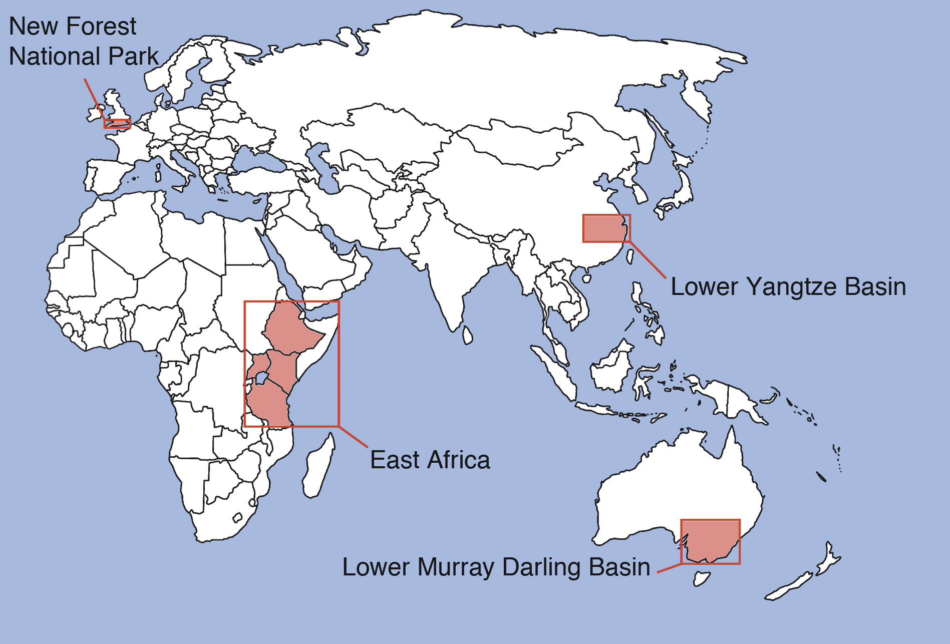
Figure 1: Map of the four regions that were the topics of four invited talks. |
The inaugural meeting of the PAGES Focus 4 Theme “Regional Integration” was held 22-24 September 2010 at University of Southampton, UK, supported by PAGES and the University of Southampton (USRG LWEC funds). Around 50 participants attended the meeting, representing all the major continental areas and with case study presentations in the form of talks and posters.
The goals of the meeting were: a) To develop methods and protocols for integrating multi-decadal biophysical and social records within sub-continental regions (data types, databases, visualization) using selected data sets from different world regions; b) To consider optimal means for reconstructing and analyzing complex, evolutionary interactions that have led to the contemporary socio-environmental system (narratives, complex behavior, resilience theory, information theory, systems modeling); and c) To outline a major multi-authored paper on the need and scope for regional integration of past records, with new protocols/methodologies using regional examples from the workshop.
On the first day, John Dearing opened the meeting with a talk that gave the background, aims and objectives to the Focus 4 Theme and the meeting. This was followed by four invited talks that described the scope and application of integrating archives in four regions.
Peter Gell (Ballarat) reported about the Lower Murray Darling Basin in southeastern Australia, an area particularly sensitive to hydrological changes. Paleodata demonstrate that the natural system is now outside its natural range of variability and that resource management must adapt to the shifted limits in water availability (also see article of Reid and Gell on page 62).
Mohammed Umer (Addis Ababa) reported on East Africa, where human impact on the landscape was moderate for a long time. Cultural traditions and religious beliefs may have supported successful resource management. Around 2.5 ka BP human impact intensified due to climate drying, increased seasonality, the advent of agriculture and iron use.
Yang Xiangdong (Nanjing) and Zhang Weiguo (Shanghai) reported on the Lower Yangtze basin and effects on the Yangtse estuary. The estuary is sensitive to human activity both locally and upstream, which poses sustainability challenges for the city of Shanghai. Sediment records show that water purity has decreased over the last 3-5 decades and sediment discharge to the estuary dropped below the long-term background with the closure of the Three Gorge Dam in 2003.
Mary Edwards (Southampton) presented research on the New Forest National Park in southern England. She highlighted landscape evolution against the backgound of changing natural and anthropogenic influences and discussed management scenarios of successful long-term management and conservation of this landscape (also see article of Edwards and Grant on page 51).
The second day was devoted to break-out group discussions around Key Questions and Answers, and Data Sources, Databases and Dynamic Modeling. Richard Treves (Southampton) and Peter Gell (Ballarat) gave short talks on visualizations of regional data. The third day focused on strategic planning of the Working Group and outlining of workshop products, with several outcomes including the selection of a Theme Steering Group and a manuscript draft for a multi-authored position paper. Case studies presented at the workshop also provided the core of the articles of this issue of PAGES news, which is accordingly dedicated to the new Regional Integration theme.
The workshop organizers felt that this was a really energetic meeting with a high level of enthusiasm, which bodes well for future activities.
Frank M. Chambers and John R.G. Daniell
Centre for Environmental Change and Quaternary Research, University of Gloucestershire, UK; fchambersglos.ac.uk
Regional paleoecological data can provide a wide range of possible restoration scenarios for degraded moorland and bog habitats.
Conservation practice in the United Kingdom (UK) uplands has been strongly influenced by policy responses to the Convention on Biological Diversity (1992). The UK was the first nation to produce a national Biodiversity Action Plan (BAP) (Department for Environment, Food and Rural Affairs, 2007a,b; UKBAP, 2008); policy is now enshrined in Habitat Action Plans (65 HAPs), Species Action Plans (1149 SAPs) and Local Biodiversity Action Plans (innumerable LBAPs), plus European designations of Special Areas of Conservation (SACs) and possible candidates (cSACs). This plethora of acronyms has emerged since Ratcliffe’s (1977) Nature Conservation Review, which focused on Sites of Special Scientific Interest (SSSIs) and National Nature Reserves (NNRs). Habitat Action Plans focus on arresting decline of diminishing habitats, restoring habitats to satisfactory condition and expanding the habitat cover where feasible (Jones et al., 2003). Implementation is devolved separately to England, Wales, Scotland and Northern Ireland, but LBAPs provide for local decision-making. However, because local conservation practitioners frequently lack scientific capacity to address LBAP activity, BAP Scientific Services (2011) recommend expertise should be drawn upon regionally.
Moorland and bog restoration
For some upland areas, it could be argued on grounds of biodiversity (following Bremer and Farley, 2010) that either economic coniferous forestry or amenity deciduous woodland would be legitimate objectives. However, if restoration of degraded moorland and blanket bog is the intention, this requires knowledge of the previous vegetation, specifically: how long it endured, which species are significantly reduced or extinct, which factors led to the claimed declines, whether those factors can be mitigated, and viable targets. Currently, restoration is predicated on decadal to sub-centennial survey data that show areal loss. For example, a 30% loss of or serious damage to blanket bog in Great Britain was estimated for the period from 1949 (when the Nature Conservancy Council was established) to the early 1980s (NCC, 1984; see also Usher and Thompson, 1988). This contrasts with thousands of years of cultural landscape history that preceded contemporary vegetation communities. Though emphasis is placed on restoration, few local conservation practitioners will be fully aware of past vegetation communities to which degraded habitats might be restored (see Hodder et al., 2009). Short-term targets and sub-decadal timescales dominate habitat restoration activity. Seldom is account taken of the millennial-scale development of upland ecosystems, shown by studies of long-term ecology (viz., paleoecology; Willis and Birks, 2006), which can be conducted on peat beneath moorland and bog vegetation (Chambers and Charman, 2004).
Favored vegetation types in the UK uplands, to which “restoration” is directed, include Sphagnum- (bog moss) dominated blanket bog and heather moorland, for which the UK has the largest expanse. The former is widespread in the Flow Country of northern Scotland (Lindsay et al., 1988), but is now relatively rare in England, Wales and Northern Ireland, owing to atmospheric pollution, drainage, burning, peat extraction, over-grazing, and afforestation with exotic conifers. Tallis (1998) calculated that in the British Isles only 18% of heather moorland remained in natural or near-natural condition.
 |
|
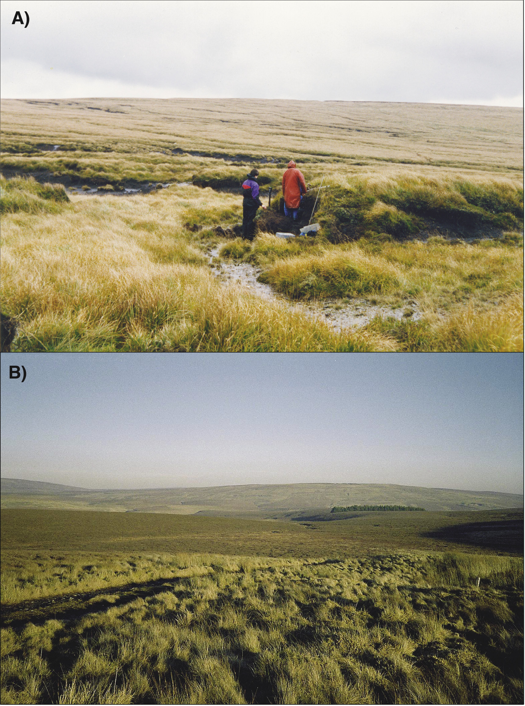
Figure 1: A) Degraded mire and moorland landscape of Drygarn Fawr, Mid-Wales, dominated by Molinia caerulea (purple moor grass). B) Valley Bog, Moor House, Northern England. The Valley Bog core site (VB1: Fig. 2b) is located in the middle ground in heather moorland. |
In the open uplands of England and Wales, large expanses of mire and moorland are occupied by the plant community Molinietum (Fig. 1A). Its vegetation provides poor grazing for sheep, which are now the principal domestic grazers. The dominant plant, Molinia caerulea (purple moor grass), is deciduous. As it has no foliage in winter and grows coarse, long stems in summer, its palatability for sheep is limited to the “spring bite”. In Northern England it provides only limited cover for the economic “game” bird, Red Grouse, which is better suited to Callunetum—heather moorland (Fig. 1B) dominated by Calluna vulgaris (ling, or common heather)—a cultural landscape maintained by grazing (Stevenson and Thompson, 1993) and controlled burning.
In contrast to blanket bog, which is mainly prized for its conservation importance, heather moorland has both economic and amenity value. However, it saw a calculated loss of 23% in Scotland within four decades (NCC, 1984), partly attributed by Robertson et al. (2001) to lack of management of some grouse moors. Heather moorland is favorably regarded for its attractive appearance in summer and early autumn, particularly for visitors to upland National Parks. These include Exmoor, in Southwest England, for which heather moorland has totemic significance, but where Red Grouse is extinct. There, “swaling” (controlled burning) is used to maintain heather, but some areas have been lost to Molinia. Landscapes dominated by Molinia are monotonous and unattractive for visitors, having low amenity value, and are regarded as degraded (Yeo, 1997).
Paleoecology informs restoration targets
 |
|
Figure 2: A) Dominant plant macrofossil abundances in a peat core from Drygarn Fawr, Mid-Wales (Chambers et al., 2007a). The rise in Molinia remains (red) occurs only after the Industrial Revolution (IR; estimated at c. AD 1900, gray shading). This rise was not caused by increased burning, as attested by no significant changes in the charcoal record at this time (black) but is likely the result of a change in grazing pressure and deposition of nitrogen following the IR. UOM: unidentified organic matter, which, in high abundance, may signify Calluna-dominated vegetation (e.g., Heather moorland). B) Dominant plant macrofossil abundances from Valley Bog, Moor House National Nature Reserve, Northern England. Heather moorland is present only in the most recent Zone (green shading, VB1–M6, characterized by abundant Ericales and Calluna vulgaris macrofossils), indicating that it has no longevity in this locality (unpublished data from Chambers et al., 2006). Timescales, calibrated to approximate calendar ages, compiled from record of spheroidal carbonaceous particles and radiometric dating (210Pb; 14C). |
Conservation agencies have targets for degraded moorland habitats, with restoration envisaged to heather moorland or conceivably to Sphagnum-dominated bog. Experimental data indicate the relative efficacy of pony grazing, use of herbicides, and burning as agents of control of Molinia caerulea (Marrs et al., 2004). However, the timing and cause of the overwhelming dominance of Molinia (variously attributed to overgrazing, lack of heather moorland management or uncontrolled burning) remained elusive until the initiation of paleoecological studies on a regional scale. Paleoecological data from Exmoor and Mid- and South Wales show the spread and expansion of Molinia only after the start of the Industrial Revolution. Importantly, the data also indicate multiple causes: not grazing pressure alone, but rather a change in the dominant grazer from cattle to sheep, nor burning alone, as Molinia has spread into areas without evidence of an increase in fire intensity or frequency (Fig. 2A; Chambers et al., 1999, 2007a, b). Additionally it has been hypothesized that nitrogen deposition post-Industrial Revolution provided Molinia with a competitive advantage in a pastoral regime of unprecedentedly high stocking density of sheep (Chambers et al., 2007b). Plant macrofossil data show that, before high density stocking of sheep, Molinia was only a minor component of the regional flora (Chambers et al., 2007a).
Regional significance of paleodata
In habitat conservation practice for moorland and bogs, the emphasis is on restoring the health of plant communities defined in the National Vegetation Classification (NVC; e.g., Rodwell et al., 1991, 2000). The NVC survey of British vegetation was conducted by expert ecologists in the late 20th century. However, as a “snapshot” of the then current vegetation, it can be criticized for lacking a sufficiently long-term perspective. Paleodata from South Wales and Northern England show the former presence of plant species regionally extinct as a result of human activity, including Sphagnum austinii (syn. S. imbricatum ssp. austinii) (McClymont et al., 2008, 2009), which was also a major peat former in raised bogs in England and Wales for thousands of years in the mid-late Holocene (Hughes et al., 2007, 2008). Regional paleodata therefore imply that inter-regional translocation of key bog species could be justified as part of future habitat restoration. Moreover, paleoecological data of former plant communities show a wider range of possible restoration targets for Molinietum than is implied by the NVC, and so broaden the range of possible replacements. They also question the longevity of some Callunetum: its endurance in some parts of England and Wales has been shorter than generally thought (Fig. 2B; see also Chambers et al., 2007b).
Davies and Bunting (2010) argue there is an urgent need to “bridge the gap” between ecology and paleoecology. The latter has fundamental implications for the future practice of conservation and habitat management: regional paleoecological data question vegetation endurance, reveal regional declines, extinctions and their causes, and can help identify a range of viable restoration targets.
references
For full references please consult: pastglobalchanges.org/products/newsletters/ref2011_2.pdf
Darren S. Crook1, R.C. Chiverrell2, J.A. Dearing3, R.T. Jones4 and K.E. Welsh5
1Division of Geography and Environmental Sciences, University of Hertfordshire, Hatfield, UK; D.Crookherts.ac.uk
2Department of Geography, University of Liverpool, UK
3Palaeoecology Laboratory, University of Southampton, UK
4College of Life and Environmental Sciences, University of Exeter, UK
5Department of Geography and Development Studies, University of Chester, UK
Integration of paleoenvironmental reconstructions, environmental history and cellular modeling sheds light on the likely impacts of climate change on hydrological and geomorphological processes in the French Prealps.
 |
|
Figure 1: The landscape of the Petit Lac d’Annecy catchment, Haute-Savoie, showing the southern end of the lake, the Eau Morte River delta, the intensively farmed lowlands, forested lower slopes and alpine pastures (Photo: John Dearing). |
By the end of the 21st century, IPCC reports (2007) suggest winter precipitation in European Alpine regions will increase by 10-20% compared with 1980–1999, while summer precipitation will decrease by approximately 20%. Here, we review findings from research undertaken in the French Prealps in order to shed light on the implications of climate change for hydro-geomorphic processes. Over the past 20 years, the Annecy lake-catchment (45°48'N, 6°8'E) has provided the focus for a number of studies, drawing on methods used in paleoecology, environmental history and process modeling, to investigate the links between human activities, climate and hydro-geomorphic processes. Lying at an altitude of 447 m asl in the prealps of Haute-Savoie, the lake comprises two basins, the Grand and Petit Lacs. Integration of data and models from mainly the Petit Lac and its catchment (Fig. 1) has generated significant insight into the spatio-temporal nature of human-environment interactions across the wider region.
Paleoenvironmental reconstruction
 |
|
Figure 2: Paleoenvironmental reconstruction and environmental history of the Petit Lac d’Annecy catchment since AD 1700. A) Changes in forested landscape based on non-arboreal pollen percentages (NAP%, green) and forest inventories (red) for the modern era and the period of Savoy from 1700 to 1860 (shaded areas show rapidly accumulating lake sediments with few pollen). B) Flood record based on documentary sources. C) Human population (yellow), accumulation rate of lake sediments (blue) and estimate of sediment yield (a composite proxy for flooding, slope instability and soil erosion) from the catchment (gray). Note the generally strong relationship between high catchment population and low forest cover, but progressively increasing levels of slope instability and soil erosion up to the mid-20th century. Rising sediment yields since the 1980s have now reached the maximum levels seen in the early 20th century. |
Foster et al. (2003) reconstructed the mechanisms of flooding and sediment transport within the Petit Lac catchment over timescales of months to centuries from lake and floodplain sediments that were representative of large catchment areas. Analysis of the results revealed that climate and land-use controls on the hydrological and sediment system were complex and varied according to the timescale of observation. In general, cycles of agricultural expansion and deforestation appeared to have been the major cause of shifts in the hydro-geomorphic system during the late Holocene. It was suggested that deforestation might have caused a number of high-magnitude flood and erosion events. The authors also argued that as the timescale of observation becomes shorter (annual rather than centennial), the impact of climate or meteorological events on hydro-geomorphic processes become progressively more important, The authors showed that since the mid-19th century, smoothed records of discharge roughly followed annual precipitation (Foster et al., 2003) whilst annual sediment load declined in parallel with the trend of declining land use pressure (Fig. 2). Episodic erosion events since the mid-19th century were linked to geomorphic evidence for slope instability in the montane and subalpine zones, triggered by intense summer rainfall (cf., Theler et al., 2010). At the annual scale, changes in seasonal rainfall become paramount in determining sediment movement to downstream locations. A recent rise in sediment yield, since the 1980s, points to a shift in seasonal rainfall patterns, which is also visible in the instrumental record (Fig. 2C).
Environmental History
Crook et al. (2002, 2004) investigated the nature of human impact on forest cover in the Petit Lac catchment and its link to flooding using local documentary sources for land use, flooding and climate. In contrast to the sediment studies, they identified the main period of large-scale, uniform and rapid deforestation in the catchment as the early 19th century (Crook et al., 2002). It was a time of demographic expansion, industrial development, foreign occupation, war, caveats and laws, linked with local, endogenous pressures of land fragmentation, agricultural crisis, and the desire for new alpine pasture. However, coincident phases of deforestation and flooding (Fig. 2) were more evident in individual second order tributaries, such as the river Ire, than the whole catchment. Overall there were no obvious or simple causal links between forest cover change, climate anomalies and destructive flood events at the whole catchment scale in either the 18th or 19th century.
In a subsequent study, Crook et al., (2004), used archeological and documentary records to reconstruct land-use patterns and nutrient balance in Montmin, an upland commune, at even finer scales for specific periods in time between AD 1561 and 1892. Previous studies by Siddle (1986, 1997) and Jones (1987) gave insight into the social fabric of the commune and the land use practices. Together, the results demonstrated that during this period seven main phases of human activity had left their traces in the environmental record. The 1730-1770s and 1840-1860s stood out as two periods of heightened environmental pressures at higher altitudes that led to documented problems in the lowlands, such as flooding, increased erosion and declining soil fertility.
Modeling
These spatio-temporal interactions were tested through a modeling exercise (Welsh et al., 2009), using the spatially distributed (50 x 50 m grid) hydro-geomorphic process model, CAESAR (Coulthard and Macklin, 2001). Changes in the hydrological and sediment regime of the sub-catchments in the Petit Lac catchment were simulated at hourly time steps over the past 180 years, with forest cover and regional climate as drivers. The results suggested that while minor perturbations in forest cover had partially conditioned the response of the sediment system, the bulk of modeled sediment discharge and particularly the peaks in sediment discharge were controlled by flood duration and magnitude. These flood parameters were in turn driven by precipitation and snowmelt. Basin geometry and geomorphology of each sub-catchment (Ire and Tamie) were also important in producing differences in the modeled sediment discharge, largely in response to sediment accommodation space and the ability of each system to store and release sediments. The modeled suspended sediment discharge was shown to compare well with lake sediment proxies for detrital sediment accumulation. The results indicated that the model could be used as an exploratory and predictive tool in assessing the likely impact of future changes in climate, meteorology and land use on lake-catchment systems.
Implications for land management
These contrasting approaches reveal the importance of interactions across different temporal and spatial scales. Different archives of information are biased towards particular scales, and high-precision process models may be essential tools for resolving apparent contradictions. For the modern French pre-alpine landscape, there are several significant lessons:
- Forest cover defines the boundary conditions for flood magnitude and slope instability over multi-decadal to centennial timescales, which has been mainly anthropogenically controlled for at least two millennia. In system dynamic terms, land cover represents the set of “slow” processes that control the system's resilience (Dearing, 2008).
- In contrast, the key drivers of short-term flooding and slope instability at commune and sub-catchment levels are linked to specific meteorological events (snowmelt and summer storms) rather than local land-use change, except where there is exceptional land degradation.
- If 21st century winter precipitation increases by 10–20%, the predicted increase in the frequency and magnitude of large flood events in winter and spring could be amplified further as water storage, in the form of snow, is reduced.
- Reducing forest cover and/or increasing frequency/magnitude of flood events render the fluvial system rich in sediment. This not only increases the rate of lateral channel migration, a hazard for farmland and buildings, but also shifts the rivers (mainly through bank erosion) to a more sediment-rich state.
- Anticipating the effects of climate change thus needs to focus on mitigation and adaptation strategies for the likelihood of more frequent extreme meteorological events causing local flooding. However, careful management of land cover across the region will also be needed to raise general levels of flood protection in the winter and spring, and reduce the risk of drought and forest fire in the summer.
Data
Some of the data discussed here can be found at http://www.liv.ac.uk/geography/research_projects/Levan/index.htm
references
For full references please consult: pastglobalchanges.org/products/newsletters/ref2011_2.pdf
Markus Dotterweich1 and Stefan Dreibrodt2
1Institute of Geography, University of Mainz, Germany; mailmarkus-dotterweich.de
2Institute for Ecosystem Research, University of Kiel, Germany
7500 years of land use and soil erosion data provide an insight into modern links between human activities and the environment.
Agricultural development and geomorphology
The development of natural and socio-ecologically adapted agroecosystems, which have the capacity to ease demand on food and resources and mitigate climate change, is a major challenge. Looking at past land-use systems and their socio-economic history increases our understanding of slow processes and low-frequency events. These underlying processes appear to be key in assessing whether modern land-use systems will lead to sustainability or collapse.
In central Europe, phases of agricultural expansion and regression occurred with land clearance and reforestation back to the onset of agriculture, around 7500 years ago. Under natural conditions (except for short phases of severe climate deterioration in the early Holocene), the sheltering cover of vegetation and soil development largely mitigated geomorphic processes, resulting in a stable dynamic equilibrium (Dotterweich, 2008). With the clearing of forests, the natural water and matter fluxes changed into anthropogenically driven systems with greatly accelerated processes and higher vulnerability to soil erosion. Repeated or extreme events forced by climate change may have affected the fertility of the land to an extent that it could no longer be cultivated. On a local- to regional scale, this may occur surprisingly rapidly, especially in strong single events. As the system develops, two outcomes may occur: a) Driving forces may progress slowly, causing gradual and predictable degradation, or b) Exceptional events may trigger catastrophic changes, forcing premature abandonment of agricultural land. Regardless of the rate of degradation, the system will evolve through a reorganization phase and ultimately reach a new equilibrium, where either naturally or anthropogenically driven processes dominate the overall system.
 |
|
Figure 1: Dynamics of soil erosion in small catchments (A) and river activity (B, C, D, E) in central Europe since the beginning of agriculture, based on studies by different authors. Blue numbers correlate to site names, type of geoarchive and references given in supplementary material (www.pages-igbp.org/products/newsletters/ref2011_2.pdf). Yellow shading represents cultural epochs (Figure modified from Dotterweich, 2008). |
As a result of these processes, erosion has changed soil conditions and patterns in many areas of Central Europe. Material has been washed downslope and gullies have incised, leading to the deposition of sediments at the slopes (colluvial layers), in floodplains (alluvial layers) or lakes (allochthonous input). These erosional landforms and depositional structures are geoarchives of past land use, human impact and climate change, at broad temporal (daily to millennia) and spatial (gully/slope to floodplains) scales. Efforts to retrieve these data have increased during the last few years (Fig. 1 and 2; Dotterweich, 2008; Dreibrodt et al., 2010; Notebaert and Verstraeten, 2010; Hoffmann et al., 2011). Based on many reconstructions of the history of soils, relief and river systems, we are now able to generalize about the fundamental effects of land use and climate on central European landscapes.
Land use or climate?
 |
|
Figure 2: Records of historical soil erosion in Germany from two lake sediment sequences (A, B), alluvial sediments (C) and slope deposits (D), compared to population density (E; Dreibrodt et al., 2010). Three methods were used for dating of slope deposits: Archeological dating (embedded finds; orange), radiocarbon dating (green), and IRSL-dating (blue). Shaded areas reflect cultural periods: MT- Mesolithic Times, NT- Neolithic Times, BA- Bronze Age, IA-Pre-Roman Iron Age, R- Roman Imperial Times, D- Dark Ages/ Migration Period, ME- Medieval Times, Mo- Modern Times. Note that the record of slope deposits and alluvial deposits for Modern Times underestimates soil erosion, as a lack of data exists for young deposits. |
The observed variability in erosion reflects, to a large extent, the varying intensity of population pressure and agricultural land use in Germany. This is illustrated by the pronounced increase in soil erosion, particularly at the onset of and during the Neolithic times (ca. 5500-2200 BC in southern and central Germany) and by the distinctive decrease in soil erosion during the migration period (ca. 300-700 AD) and the early Medieval times (ca. 700-1000 AD) (Fig. 2) (Dotterweich, 2008). It seems that centennial-scale climate change affected the observed variability by modifying the boundary conditions for erosion. For example, there are few erosion records from the early and middle Bronze Age (ca. 2000-1600 BC), a period known to have been a prominent dry period in central Europe (Dotterweich, 2008). The most remarkable phase of soil erosion occurred in the first half of 14th century, at the beginning of the Little Ice Age. The second well-known intense soil erosion phase occurred in the mid-18th to early 19th century—at the end of the Little Ice Age. Historical records document extreme precipitation events during these two phases, implying an influence of climatic extremes on geomorphological processes. However, certain phases of the record remain unexplained. For instance, during Roman Emperor times (27 BC-476 AD) there is little indication of soil erosion even though there is no evidence for particularly dry conditions and population density was high (Fig. 2). As a general finding, the majority of the studies on soil erosion in small catchments indicate that sediment fluxes are highly sensitive to changes in local land use, while climate change plays a secondary role.
Legacies of catastrophic events
Most of the gully systems in central Europe today are a result of catastrophic rainfall events. In the year 1342 AD, for example, extreme erosion events initiated many gully systems and hill slope erosion delivering over 50% of the total colluvial material that exists today in the investigated areas in central Europe (Dotterweich, 2008). A few extreme events were responsible for most of the currently deposited slope sediments, significantly modifying flood and erosion regimes of the landscape. This period in history marks the change from natural- to human-dominated systems—a legacy that has ramifications for today's landscape. The ability of extreme events to cause steep changes in these landscapes, effectively changing the regional boundary conditions, should be seen as a warning for the potential impacts of extreme events in future climates. It also means that conventional modeling and assessment tools used for sustainable management strategies may be inadequate to accommodate legacies and complex interactions over decadal and centennial timescales because they generally don’t integrate extreme events.
Human-environment feedback
In contrast to reconstructions of geomorphic and pedologic history, there are only a few studies concerning possible feedbacks from land use. These studies equate societal collapse to vulnerability to climate change, agricultural maladaptation or a mixture of both. For example, historical studies show that during the first half of the 14th century, many villages in Germany were abandoned as an ultimate consequence of a combination of socio-cultural processes, crop failures and soil degradation (Bork et al., 1998; Dotterweich, 2008). Food prices became very expensive in several consecutive years of the first half of the 14th century because of shortages as a consequence of soil degradation and economic mismanagement (Fraser, 2010). This unfavorable socio-economic, nutritional, and health situation might have prepared the ground for the European-wide pandemic, namely the Black Death, between 1347 and 1351 AD. In the 18th to early 19th centuries, soil erosion and crop failures led to major migration overseas. Soil erosion appears to have been one factor in a complex causality spiral leading to socio-economic instability and land-use changes.
Modern day environments
In light of historical and recent data (severe floods with high costs to our societies), we now have new insight into the interactions between societies and their environment. This type of research has the potential to help in the development of modern sustainable land-use strategies by providing evidence for the different timescales and complexity of interactions between human activities and geomorphic responses. However, many past studies combine and correlate different time series, assuming causality and neglecting the legacy of past forcings and responses. Future approaches must better distinguish proximate from ultimate causes to deliver a new understanding of complex system behavior. The research also has to extend the scope of analysis to the full spectrum of human–environment interactions including the demise of agriculturally marginal systems and the histories of more subtle, adaptive and cumulative changes and processes. This will extend our observation of background processes in modern human-dominated landscapes and their natural variability. Past records have an important role to play in the creation of adaption strategies for complex agricultural systems around the world.
references
For full references please consult: pastglobalchanges.org/products/newsletters/ref2011_2.pdf
Mary Edwards1 and Michael J. Grant2,3
1Geography and Environment, University of Southampton, UK; M.E.Edwardssoton.ac.uk
2Wessex Archaeology, Salisbury, UK; m.grantwessexarch.co.uk
3School of Geography, Geology and the Environment, Kingston University, UK
Paleoecology, in combination with more recent ecological observations and future climate projections, can play a key role in providing a robust basis upon which to build ecological management strategies for important biodiversity areas.
The New Forest: Management dilemmas
 |
|
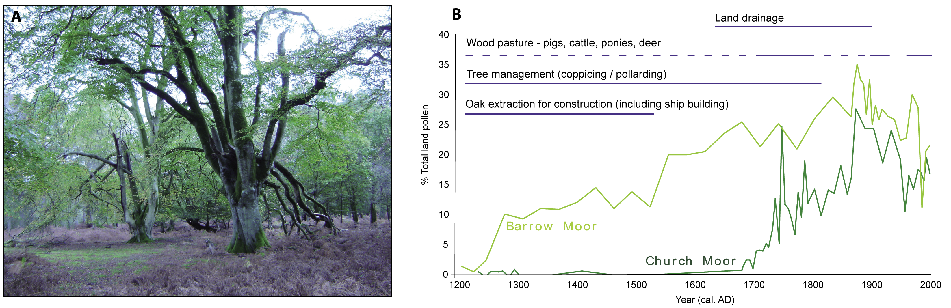
Figure 1: A) Typical A&O Woodland featuring over-mature, previously pollarded beech trees (Photo M.J. Grant). B) Pollen percent curves for beech (Fagus) at two valley mire (peatland) sites, Barrow and Church Moor, located within Mark Ash Wood. Both curves are at their highest between ca. 1700 and 1900 AD and subsequently decline, however at Barrow Moor the initial increase in Fagus occurs several hundred years earlier than at Church Moor. The horizontal lines indicate past land use practices, dotted lines indicate less certain records. |
National parks in Britain are managed for multiple uses: they are often scenic areas and attract numerous visitors, they support local economies beyond tourism, particularly agriculture and forestry, and they are foci of biodiversity. Climate change introduces uncertainty to this challenging and sometimes conflicting land use mixture, and will affect management strategies for the 21st century. The New Forest (Fig. 1a), which lies just to the west of Southampton in central southern England, is one of the UK’s newest parks, and was established in 2005. Its landscapes and ecosystems give rise to outstanding lowland scenery and there are well-established amenity uses (it is only two hours from London). High levels of biodiversity, compared with the agricultural regions and urban areas that surround it, have attracted numerous national and European directives on species and habitat conservation. The medieval wood-pasture system maintained via customary rights and administered by a local court, is recognized as a unique cultural attribute that is closely linked with the Forest’s ecology and landscapes. The future of the New Forest will depend upon the management strategies of government agencies, landowners, and the local user groups who practice customary rights such as stock grazing. Increasingly, it will depend upon the interaction of climatic factors and the constituent species of its ecosystems. The Forest features a range of highly valued habitats; here we examine one habitat type of high biodiversity and amenity value, the so-called “Ancient and Ornamental Woodland” (A&O Woodland; Peterken et al., 1999; Tubbs, 2001; Fig. 1A).
The A&O Woodlands form part of a mosaic that also contains open heath, grazed lawns and plantations, reflecting both traditional uses and more recent commercial forestry activities. The current dramatic appearance of many woodlands, typified by large, often over-mature, beech (Fagus sylvatica; Fig. 1A), is likely due to 100 years of abandonment that followed a period of intensive management. Formerly, beech was pollarded (cut above head height) in association with wood-pasturing, fuel and timber production (Rackham, 2003). A dilemma for managers is that many visitors appreciate the current appearance of the A&O woodland, but ecologically and structurally the system is gradually being transformed. To be maintained in the longer term, it must undergo a managed regeneration cycle that will inevitably alter current conditions over the decades to come. Knowledge of the past cultural and environmental conditions that have led to the development of the current system can inform current management choices and provide a temporal perspective on the key question of whether long-term sustainability of this landscape and ecosystem is truly achievable (see Grant and Edwards (2008) for more details).
Long-term record of beech
Two valley mire deposits lying within A&O Woodland were selected for pollen studies: Barrow Moor and Church Moor, located ~600 m apart from each other. The pollen record of Fagus (Fig. 1B) shows that it did not become a significant component of the woodland until a few hundred years ago and that its expansion was locally asynchronous. At both sites, expansion coincided with an increase in holly (Ilex aquifolium), the herbs Plantago lanceolata and Rumex spp., and bracken (Pteridium aquilinum), all indicative of increased grazing pressure, and a decline in hazel (Corylus avellana). This last development may relate to the deliberate removal of hazel, abandonment of coppicing (a traditional woodland management method where trees are cut at ground level) and a shift to wood-pasture, or increased grazing pressure. Selective removal of oak (Quercus robur), particularly for naval construction (Flower, 1980; Tubbs, 2001) and possibly enhanced drainage, also favored expansion of beech. The overall importance of beech appears to decline during the 20th century at both sites. Thus beech dominance within the A&O Woodlands is relatively recent, likely related to human intervention rather than natural processes alone, and is now decreasing.
Locally, ecological monitoring of New Forest A&O Woodlands for up to 50 years reveals a clear decrease in canopy and understory extent, particularly for beech, which can be related to several processes: high grazing pressure limiting regeneration, direct removal of holly from some areas, death or stress damage to trees following the severe drought of 1976 and the hurricane of 1987, and grey-squirrel damage (Mountford et al., 1999; Mountford and Peterken, 2003).
At broader spatial and temporal scales, the Holocene pollen sequence from Church Moor (Grant et al., 2009) and other localities in southern England indicate that beech was present as early as 6 cal ka BP, initially at extremely low abundance (1-2%). Its expansion typically appears to be associated with anthropogenic activity in the late Holocene. In the High Weald area of southern Britain, south of London, beech expansion is also related to a change in land use, particularly to the adoption of the wood-pasture system (Waller and Schofield, 2006). Pannage (feeding by domestic pigs on acorns) may have particularly favored beech, as its seeds are highly dependent upon ground disturbance for establishment (Björkman, 1999; Watt, 1923).
Future trends
 |
|
Figure 2: Past, present and future trajectories of A&O Woodland in relation to environmental pressures and management options (Modified from Grant and Edwards, 2008). |
A combination of natural and human-induced processes over the past several hundred years has led to the development of modern A&O Woodlands as a New Forest landscape element. Figure 2 summarizes the drivers of past change, contemporary pressures and possible future for A&O Woodland. Sustaining the culturally generated structure and composition may require revival of the traditional management practices that formed the current landscape (or substitutes that achieve the same effect). The balance (or imbalance) between openness and regeneration reflects levels of grazing and browsing by stock and wild deer, and thus there is a role for stock and deer management. The current age structure already contributes to any future trajectory, and further opening of old stands within the present woodlands is inevitable. It will now be some time before a new generation of trees matures, irrespective of which management strategy is adopted. Furthermore, any long-term management intervention now also requires anticipation of climate-change pressures. For example, beech is susceptible to wind-throw, which will increase with projected greater storminess. Revival of pollarding on younger trees would mitigate wind-throw while also continuing a traditional past practice that underlies the structure and composition of contemporary A&O Woodland. On the other hand, projected levels of summer drought in the south of England may stress beech to an extent that it cannot thrive, in which case the woodland will follow a different trajectory and A&O Woodlands as they are known today will eventually take on a new composition and appearance.
Data
More detailed accounts of the pollen data can be found in Grant and Edwards (2008) and Grant et al. (2009); the pollen data will be deposited with the European pollen database (www.europeanpollendatabase.net/) in due course and, until then, are available from M.J. Grant upon request.
references
Tubbs, C.R., 2001: The New Forest: History, Ecology and Conservation, New Forest Ninth Centenary Trust, 450pp
For full references please consult: pastglobalchanges.org/products/newsletters/ref2011_2.pdf