PAGES Magazine articles
Andrea Kiss1, R. Brázdil2, M. Barriendos3, C. Camenisch4 and S. Enzi5
Historical climatology is a rapidly developing interdisciplinary field in Central, Eastern, and Southern Europe, transforming qualitative weather-related descriptions as well as phenological and physical data from documentary sources to quantitative high-resolution climate reconstructions, thus allowing for the study of the impacts of climate variability on society.
Among paleoclimate proxies, the transformation of descriptive qualitative information and documentary evidence to quantitative data (see e.g. Pfister and Brázdil 1999) has provided the highest resolution information for the reconstruction of temperature, precipitation, and other weather-related extremes over the last 500 years. Even if the time period covered is often shorter than that of most climate proxies, reconstructions may cover every month of a year. To date, Central and Southern Europe hold the largest documentary-based flood and drought collections as well as the most comprehensive and longest (index-based) local-regional temperature and precipitation reconstructions, and have played a key role in investigations where all major regions of Europe were represented (e.g. Brázdil et al. 2018; Blöschl et al. 2020). As for timescale, the temporally densest (often daily) documentation is available from Central and Southern Europe for the last 200-300 years; monthly seasonal data can be gathered for the last 400-500 years. Occasionally, representative data may cover ca. 700-800 years; however, regarding weather-related extreme events, documentary evidence in certain areas of Southern Europe may cover a period over the last two millennia or more (Camuffo and Enzi 1996).
Southern Europe
In Southern Europe, the reconstruction of hydroclimatic extremes, i.e. droughts and floods, on a multi-centennial scale is currently a large focus within flood and drought databases, sometimes reaching back two millennia. Major source types applied are narratives (esp. chronicles), church and municipal legal and economic administrative documentation, and, to a lesser extent, private and official correspondence and newspapers. Most research is concentrated on the Iberian Peninsula and Italy.
Research on the Iberian Peninsula concentrates particularly on flood- and drought-severity reconstructions over the last ca. 700 years (e.g. Oliva et al. 2018; Barriendos et al. 2019). While early research mainly draws upon municipal legal and economic records, later research primarily focuses upon rogation ceremonies, a complex social demonstration of droughts systematically preserved in the administrative sources of municipal and ecclesiastical institutions. Despite significant results in Spain and Portugal, documentary evidence still holds immense further potential; to date, only around 4% of historical sources have been exploited by historical climate research.
 |
|
Figure 1: Examples of types of sources applied in reconstructions. For details, see below. |
From the Iberian Peninsula, continuous early instrumental measurement series date back to the mid-/late 18th century; Italy holds the earliest systematically measured daily series of temperature and precipitation dating back to 1654 and 1713, respectively. Except for a 500-year rainfall reconstruction of the Iberian Peninsula, mostly individual-local and no regional-scale temperature or precipitation index reconstructions exist in Southern Europe (Camuffo et al. 2010). Southeast Europe, apart from the grand collection of medieval Byzantine weather reports (e.g. Telelis 2008) and occasional individual publications, remains underrepresented in systematic research. Besides the reconstructions of hydroclimatic extremes, long-term socio-economic impacts of changing weather conditions and weather-related extremes, especially droughts, also play a rather important role in Southern Europe (e.g. Gil-Guirado et al. 2016).
Central Europe
Central Europe is perhaps the most intensively involved area in historical climatology research within Europe. With a few gaps, index-based reconstructions of temperature, precipitation, and/or weather-related extreme events (e.g. floods, droughts, and windstorms) are available from most parts of Central Europe for the last 500 years or millennium (e.g. Glaser 2013; Brázdil et al. 2016). This is the only area of Europe where a complete regional monthly-resolution (index-based) 500-year temperature reconstruction is available: the Central European reconstruction (Dobrovolný et al. 2010), developed within the framework of the Millennium project (2006-2010), was published together with its other results as a historical climatology special issue of the journal Climatic Change (vol. 101, 2010). The annual resolution spring-summer temperature over the last 400-500 years were also published from most countries of Central Europe including Switzerland, the Czech Republic, Germany, Austria, and Hungary, in some cases accompanied by precipitation reconstructions. These were based on systematic daily resolution information on vine and grain phenophasis dates, such as blossoming, ripening, and grain and grape harvesting.
In Central Europe, from the Middle Ages onwards, the key source types applied are narratives (e.g. annals, chronicles, and diaries), official and private correspondence including newspapers, and partly systematic economic and legal administrative documentation (municipal accounts, council minutes, charters, accounts, and taxation records). Except for those countries with systematic historical climate research, such as the Czech Republic, Switzerland, and Germany, the latter two source types, together with specialized agricultural, weather and phenological diaries, and early instrumental records (from the early/mid-18th century) and daily weather observations, are still to a large extent unexplored, and hold immense potential for further high-resolution multi-centennial reconstructions in the rest of Central Europe.
A further important research area is historical impact analysis of individual catastrophic weather and hydroclimatic events, anomalous periods, or long-term interactions and processes (e.g. Camenisch et al. 2016). In recent years, the attribution of major food shortages in historical times to severe weather conditions, as well as the climatic and socio-economic impacts of major volcanic eruptions in Central Europe, particularly the Tambora eruption and the Year Without a Summer, in 1816, have attracted further attention (e.g. Luterbacher and Pfister 2015).
 |
|
Figure 2: Long-term documentary-based flood, drought, storm, and monthly or seasonal temperature and precipitation reconstructions and grain- or grapevine-based temperature reconstruction series in Central, Southern, and Eastern Europe by country. |
Eastern Europe
In Eastern Europe, including Russia, the Baltic countries, Belarus, Ukraine, and Moldova, climate-history research is currently based on narrative sources, in particular chronicles and annals. Temperature, precipitation, and extreme-event reconstructions, derived from data in the major northern Russian chronicles and annals that cover most parts of the last millennium, have been carried out by Borisenkov and Pasetskiy (2002). This work has been criticized by some for the source interpretation methods used. The medieval part of this work was updated and summarized by Klimenko and Solomina (2010) in a volume discussing the historical climatology of the Polish-Lithuanian Commonwealth.
Early instrumental measurements and professional daily observations extending back to at least the mid-18th century have only been partially explored. No investigations have been carried out, so far, using other source types such as systematic legal administrative documentation, or economic sources such as accounts at the municipal, estate, district, regional, and country level; this documentation still holds great potential in Eastern Europe.
Recent highlights
While in previous decades, long-term temperature and precipitation reconstructions and early instrumental measurements were the main priority, in recent years, individual extremes and the long-term reconstruction of hydroclimatic extremes have received greater attention. Aside from individual flood and drought reconstruction papers, European and global-scale special issues on historical floods ("Floods and their changes in historical times" in Hydrology and Earth System Sciences: 2015-2016) and droughts ("Droughts over centuries" in Climate of the Past: 2019-2020, "Societal impacts of historical droughts" in Regional Environmental Change: 2019-2020) contain dozens of studies with new, multi-centennial reconstructions, particularly from Central and Southern Europe. Furthermore, with particular attention paid to Central and Southern Europe, regional and continental-scale online databases have been developed in the last decade(s) and opened for public use in recent years (e.g. Euro-Climhist, Tambora).
A research direction that is rapidly growing in importance is climate history that deals with the impacts of weather and weather-related extremes on the human environment, human responses on these impacts and consequent socio-economic processes, and the short- and long-term socio-economic consequences of climate variability including the complex interaction between climate and the human environment. Beyond the early modern case studies focussing on regional or European climatic extremes, there is currently a strong emphasis on the impacts of weather in anomalous periods of the (late) Middle Ages, the Late Medieval-early modern Period, and the transition from the Medieval Warm Period to the Little Ice Age, with special emphasis on Southern and Central Europe (e.g. Kiss and Pribyl 2020).
Despite intensive work over the last three decades, historical climatology and climate history are still developing fields with great further potential as, to a regionally varying extent, a large part of the documentary evidence is not yet explored. This is particularly true for Eastern and Southeast Europe, but even most areas of Central and Southern Europe still offer numerous further possibilities for future historical climatological research.
affiliations
1Institute of Hydrology and Water Resources Management, Vienna University of Technology, Austria
2Institute of Geography, Masaryk University; Global Change Research Institute, Czech Academy of Sciences, Brno, Czech Republic
3Department of History and Archaeology, University of Barcelona, Spain
4Oeschger Centre for Climate Change Research, Department of Economic, Social and Environmental History, University of Bern, Switzerland
5Institute of Atmospheric Sciences and Climate, National Research Council of Italy, Padova, Italy
contact
Andrea Kiss: kiss hydro.tuwien.ac.at
references
Barriendos M et al. (2019) Glob Planet Change 182: 102997
Blöschl G et al. (2020) Nature 583: 560-566
Brázdil R et al. (2016) Clim Res 70: 103-117
Brázdil R et al. (2018) Clim Past 14: 1915-1960
Camenisch C et al. (2016) Clim Past 12: 2107-2126
Camuffo D et al. (2010) Clim Change 101: 169-199
Dobrovolný P et al. (2010) Clim Change 101: 69-107
Gil-Guirado S et al. (2016) Clim Change 139: 183-200
Klimenko V, Solomina O (2010) In: Przybylak R et al. (Eds) The Polish Climate in the European Context. An Historical Overview. Springer, 71-102
Luterbacher J, Pfister C (2015) Nat Geosci 8: 246-248
Oliva M et al. (2018) Earth-Sci Rev 177: 175-208
Pfister C, Brázdil R (1999) Clim Change 43: 5-53
Telelis IG (2008) Jahrbuch der Österreichischen Byzantinistik 58: 167-207
Figure 1
1) Danube (and Inn) flood marks on the wall of the Town Hall in Passau, Bavaria (Germany), erected between 1501-2002, and the wet mark of the June 2013 flood (photos by the author).
2) Original charter (application to the archbishop) describing the vehement/frequent floods that made for the inhabitants of Lehota (Slovakia) very difficult (also in the recent past) – often impossible – to reach their parish church along the River Hron. Document issued on 24 June 1309 (Hungarian National Archives, Collection of Medieval Documents: DL 63903).
3) Battle on the ice (of Lake Peipsi/Chud) between Nowgorodians and the Teutonian Knights on 5 April 1242 (a famous hard winter), in the illuminated Russian chronicle "Life of Alexandre Nevsky".
4) The so-called "Weihnachtsflut 1717", the extraordinary double sea surges of Christmas 1717 and 25 February 1718 along the North Sea and the Baltic Sea coasts of Germany. Copperplate from the book: Adelsheim, Philomon. Neuer und Verbesserter Kriegs-(,) Mord- und Tod-(,) Jammer- und Noth-Calender/ Auf das Jahr nach der gnadenreichen heiligen Geburt unsers HErrn und Heilands JEsu Christi M DCC XIX... Johann Andrea Endters sel. Sohn und Erben, Nürnberg. 1719.
5) Aleksey Bogolyubov: Religious procession in Yaroslavl, 1863. Oil painting (from 1863, also drought year in Central Europe), Yaroslavl, Russia.
6) Daily (monthly, seasonal) weather observations of Zsigmond Torda between 1558 and 1568 (mainly Bratislava, Slovakia), inserted into the book: Ephemerides Nicolai Simi Mathematici Bononiensis Ad annon XV. Incipientes ab anno CHRISTI MDLIIII. vsq; ad Bononiae diligentissime collatae. Eiusdem canones usum ipsarum Ephemeridum explicantes, ac mira facilitate declarantes: praeterea tractatus de Electionibus, de Mutatione aëris, ac de Reuolutionibus annorum etc. ... Venetiies, ex officina Erasmiana Vincentii Valgrisii. MDLIIII. (Library of the Eötvös Loránd University in Budapest. Manuscript and Rare Book Collection, Cat. No. G 325). Private diaries including regular weather observations were frequently inserted into contemporary printed Ephemerides or Calendars in Central Europe (most typically between the late 15th and 18th centuries).
7) The Book of Vinesprouts in Kőszeg (1740-): 24 April 1868 and 24 April 1869. Providing (average) phenological information (length of vinesprouts as real-size drawings or paintings, timing of blossoming, quality of wine in description) for each year regarding the Kőszeg vineyards since 1740 (Jurisics Miklós Municipal Museum, Kőszeg, Hungary).
8) Wienerisches Diarium (later: Wiener Zeitung) cover page, No. 67, 21 August 1728 (Vienna, Austria). Although newspapers are occasionally available from the 16th century in Central Europe, weather-related reports became a systematic part of newspapers particularly from the 18th century onwards. One of the most important newspaper on Central Europe, containing occasional reports on weather disasters (and from the late 18th century systematic weather reports) and continuous from 1703, was Wienerisches Diarium/Wiener Zeitung.
9) The summer-autumn 1717 volume cover page from: Kanold, Johann. Sammlung von Natur- und Medicin-, wie auch hierzu gehörigen Kunst- und Literatur-Geschichten, So sich An. 1717. In den 3. Sommer-Monaten In Schlesien und andern Ländern begeben. Michael Hubert, Breslau, 1718. The Bresslau series (Wrocław, Poland; between 1717 and 1730) contains the systematic, printed reports of the first known Central-European medical and meteorological observation and measurement network.
10) Sample page from the manuscript of daily (three times) temperature and pressure measurements and air temperature, cloudiness and precipitation observations carried out by the pharmacist Károly J. Klapka between 1780 and 1803: Observationes Thermometricae et Barometricae a 1a Septembris 1780. usque ultimam Decembris 1803. Temesvarini factae per C. J. Klapka (Library of the Eötvös Loránd University in Budapest, Manuscript and Rare Book Collection, Cat. No. E 40). Timişoara, Romania.
11) Execution of witches on 4 November 1585 in Baden, Switzerland (in the famous drought year of 1585). Painted image available in: Wick, Johan Jakob. Sammlung von Nachrichten zur Zeitgeschichte aus den Jahren 1560-87 (Zürich Central Library, Wickiana Collection, Manuscript F 33), fol. 277r.
12) Sopron Town Council Minutes: September 1592 (Győr-Moson-Sopron County Archives, Sopron Archives, IV. A: 1003a, Sopron, Hungary), council minutes determining the first day of grapevine harvesting.
13) Bella, Gabriele. Venice Frozen Lagoon, 1709 (oil painting about the famous European wide hard winter of 1708-1709 in Venice, Italy).
14) Bratislava town accounts 1485-1486 (Bratislava Capital Archives, A. XXIV.1: K 46, 129, Bratislava, Slovakia). Accounts about the extraordinary ice jamming during the hard winter of 1485-146 that destroyed the Danube bridge system in December 1485.
15) Crusius, Martin. Diarium. 1 January 1602–19 September 1604, Tübingen, Germany (Eberhard Karls University Tübingen, University Library, Mh 466-9), with systematic short, daily notes on the characteristics of weather.
Chantal Camenisch1, S. White2, Q. Pei3 and H. Huhtamaa1
This issue of the Past Global Changes Magazine presents the state of research in the field of historical climatology. Its articles examine different regions of the world and review innovative methodological approaches, recent scientific results, and analyses of new source materials.
Historical climatology applies the methods and insights of historical and climate science to human records, or the archives of societies. Weather descriptions and climate proxies found in these sources, such as data on plant or ice phenology, enable the reconstruction of past climates and weather as well as their historical societal impacts.
A strength of historical climatology is the recovery of precisely located and dated information on climate and weather before the modern instrumental record. In parts of China, this information extends back more than a millennium, while in Europe evidence becomes abundant from the Late Middle Ages onwards (since ca. 1400 CE). Historical climatology research also benefits from collaboration with paleoclimatologists and climate modelers.
This issue was created in connection with the PAGES working group Climate Reconstruction and Impacts from the Archives of Societies (CRIAS; pastglobalchanges.org/crias), which started its activities in 2018. CRIAS aims to develop best practices, international collaboration, and methodological innovation in the reconstruction of historical weather and climate and their societal impacts. To this purpose, CRIAS provides a hub for researchers from different continents and different disciplines to exchange perspectives, methods, and data.
 |
|
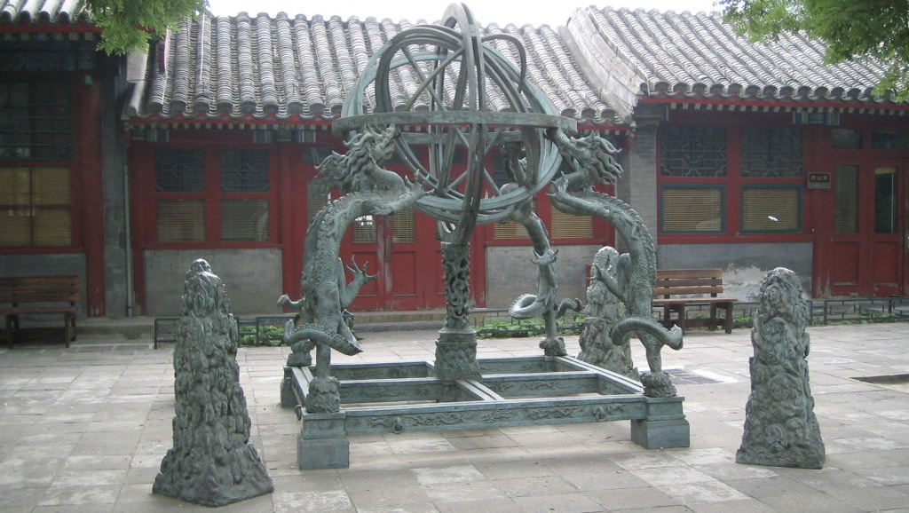
Figure 1: Ancient Observatory (古觀象臺) in Beijing, China. (Photo credit: Q. Pei.) |
This issue opens with a selection of articles presenting research results from recent years for different world regions. Kiss et al. (p. 36) examine Southern, Central, and Eastern Europe, while Camenisch et al. (p. 38) examine recent research in Northern and Western Europe, both focusing on climate reconstruction. Williamson and Pei (p. 40) present the rich historical climatology source materials of East and Southeast Asia, as well as typical methods for their analysis. Nash and Hannaford (p. 42) provide an overview of historical climatology on the African continent.
In the second part of this issue, we present methodological considerations, innovative results, and promising new source materials. White and Pei (p. 44) discuss the integration of quantitative and qualitative perspectives when assessing the impacts of past climates and extreme events on societies. Brown et al. (p. 46) demonstrate what traditional field names in England can tell us about the history of the environment and especially the history of flooding. Jusupović and Bauch (p. 48) deal with the potential of ancient Russian sources for historical climatology. Huhtamaa et al. (p. 50) discuss the combination of tithe and tree-ring data in Scandinavia, and Ouellet-Bernier and de Vernal (p. 52) present a climate reconstruction for the Labrador region of Canada from the 18th to mid-20th centuries. Two papers deal with fantastic and rich historical sources from Arab regions. The first by Meklach (p. 54) focuses on the Maghreb, and the second by Ott (p. 56) on the Middle East during the Mamluk era. Finally, Burgdorf (p. 58) presents a comprehensive database project on early instrumental measurements.
The range of perspectives and results in this issue demonstrate the importance of the archives of societies and analysis of these documents by historical climatologists for an interdisciplinary understanding of past global changes and their human dimensions.
affiliations
1Oeschger Centre for Climate Change Research and Institute of History, Section of Economic, Social and Environmental History, University of Bern, Switzerland
2Department of History, Ohio State University, Columbus, USA
3Department of Social Sciences, Education University of Hong Kong, Hong Kong
contact
Chantal Camenisch: chantal.camenischhist.unibe.ch
Juan Antonio Ballesteros Canovas1, L. Schulte2, J.P. Corella3 and B. Wilhelm3
Geneva, Switzerland, 11-13 November 2019
The second phase of PAGES' Floods Working Group (FWG; pastglobalchanges.org/floods) started in January 2019 and will run for three years. The main goal of this second phase is to develop the core activities jointly identified during the first phase (Wilhelm et al. 2017). This workshop in Geneva (pastglobalchanges.org/calendar/26943) allowed us to discuss and advance towards the realization of these objectives. Thirty-two researchers from 12 countries attended, of which more than 30% were early-career scientists. The workshop also benefited from contributions by Dr. Karen Sudmeier-Rieux, representative of the United Nations Environment Program, and Dr. Marie-France Loutre, Executive Director of PAGES.
The workshop was divided into two sessions. The aim of the first session was to discuss a range of methodologies that integrate multiple natural and historical archives to provide comprehensive paleoflood records for Disaster Risk Reduction (DRR) schemes, while the second session was mostly dedicated to discussing the occurrence and magnitude of floods during past warm and cold periods.
During the first session, the benefits of paleoflood information in DRR schemes were shown throughout different examples. A particular focus has been placed on the dimensioning of key infrastructures such as spillways in hydropower dams, or flood hazard assessments in regions with scarce instrumental data. The workshop participants agreed that advances in the inclusion of historical and paleoflood records in flood hazard assessment were achieved during recent years as well as in its incorporation to derive flood frequency (England et al. 2018). Participants also highlighted that to improve the applicability of paleofloods in DRR, the engagement of stakeholders is crucial.
 |
|
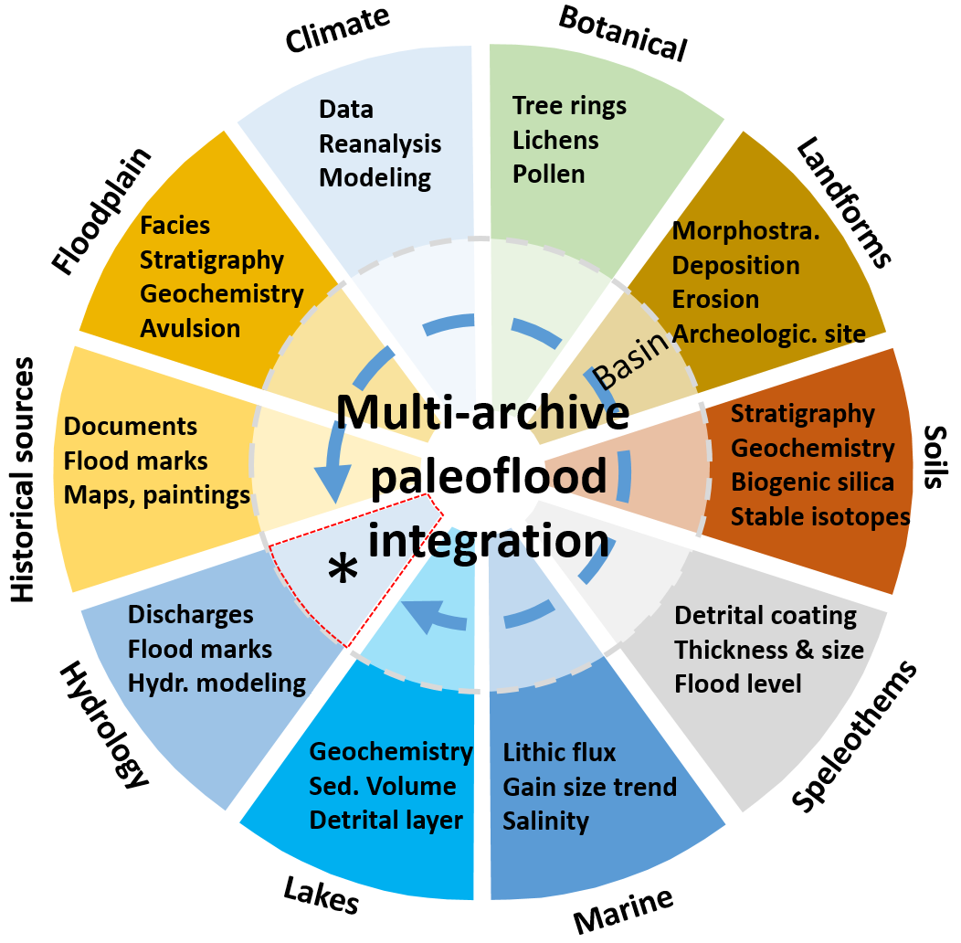
Figure 1: Concept of multi-archive paleoflood integration (in colored slices) according to the type of flood archive (e.g. climate, botanical) for obtaining long-term flood records useful for flood risk preparedness and mitigation (*) . Adapted from Schulte et al. (2019). |
Participants concluded that an integrated methodological and multidisciplinary approach is imperative to improve the potential replicability of paleofloods research worldwide. This effort, initiated during the FWG session at the PAGES Open Science Meeting 2017 in Zaragoza, is also documented by the 18 research papers compiled in the Special Issue "Pluridisciplinary analysis and multi-archive reconstruction of paleofloods", which was published in the journal Global and Planetary Change (Schulte et al. 2019).
In addition, we noted the importance of enhancing the communication between paleohydrologists, hydrologists, flood engineers, and decision-makers is essential to anticipate impacts of floods. In particular, participants discussed the possibility of developing an interdisciplinary audiovisual project as a way to transmit the benefits of including paleofloods in DRR to a broader community. At the same time, participants have started to collect ideas for writing a joint paper on paleofloods and DRR.
During the second session, several reconstructions of past flood activity during cold and warm periods were shown worldwide. The workshop attendees discussed the importance of establishing the relationship between changes in the atmospheric variability and flood occurrence. Time-space analysis of regional flood-rich and flood-poor periods allows us to anticipate future changes through our understanding of the forces that control flood occurrence. According to the different methodological approaches and regional studies presented at the workshop, which mostly covered the last centuries, higher flood activity in many catchments was linked not only to warmer periods but also to colder climate pulses. Yet, flood magnitude and timing evolved differently in different records and regions.
Participants recognized that developing the global database could be challenging due to difficulties in data integration from different archives and the significant amount of time required for this project. However, we came to a consensus that completing the interactive database of metadata of existing records remains a priority (pastglobalchanges.org/science/wg/floods/wp1).
Finally, different upcoming FWG-related activities were presented, such as the 6th International Paleoflood Conference in New Zealand (January 2020); a FWG-related session at the EGU General Assembly (3-8 May 2020); and the possibility to organize the 7th International Paleoflood Conference in Zamora, Spain (2022). More information about the workshop, upcoming projects and activities is available on the FWG website.
Acknowledgements
We thank PAGES and the section of Earth and Environmental Science of University of Geneva for the financial support, as well as Alejandra Jimenez, Clara Rodriguez, Alberto Muñoz, and Victorine Castex for their support during this workshop.
Affiliations
1Department of Earth Science, University of Geneva, Switzerland
2Department of Geography, University of Barcelona, Spain
3Univ. Grenoble Alpes, CNRS, IRD, Grenoble-INP, IGE, France
Contact
Juan Ballesteros: Juan.Ballesterosunige.ch
References
Martin Bauch1, S. White2, C. Camenisch3, Q. Pei4 and H. Huhtamaa5
2nd CRIAS workshop, Leipzig, Germany, 7-8 October 2019
PAGES' Climate Reconstruction and Impacts from the Archives of Societies working group (CRIAS; pastglobalchanges.org/crias) held its second workshop at the Leibniz Institute for the History and Culture of Eastern Europe (GWZO; pastglobalchanges.org/calendar/26945). This was the second year of Phase 1 of the working group and demonstrated progress on the goals defined during the first workshop held in Bern, Switzerland, in October 2018 (pastglobalchanges.org/calendar/26807).
These goals were defined as:
(1) the development of methods and international comparisons in historical temperature and precipitation indices;
(2) the development of Chinese historical climatology through calibration and verification with phenological and early instrumental data; and
(3) the further integration of historical climatology results from beyond Europe, especially results from evidence not previously used for climate reconstruction.
Finally, (4) the group decided after the Bern meeting to work towards an online exhibition of historical climatological objects, in order to reach a wider public.
At the conclusion of the Leipzig meeting, participants discussed the organization of the results and ongoing research into articles for a journal special issue, which was subsequently submitted as a proposal to Climate of the Past.
Regarding the first goal, lead author D. Nash presented an advanced draft of the first global review of methods for producing temperature and precipitation indices based on written evidence. This CRIAS product will provide a foundation for comparing results across world regions and improving practices in this method for quantifying qualitative documentary evidence.
G. Adamson presented trials in the creation of indices by teams of students and experts, in order to establish the consistency of results and appropriate number required to produce valid results. S. White explained a Bayesian approach to indexing, which could draw on the wealth of historical evidence and probabilistic inferences that have necessarily been left out in current indices, and C. Camenisch examined its reconstruction skill in a sample of historical data.
 |
|
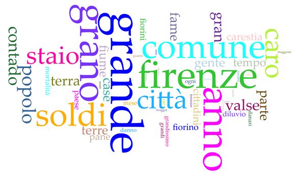
Figure 1: A word cloud created with Voyant Tools based on all reports on weather extremes and food prices/crisis in Giovanni Villani's Nuova Cronica published in the 14th century. |
Q. Pei discussed ways to examine indices, particularly the analysis of autoregression, to determine whether the statistics of index values resemble the statistics of actual seasonal and annual climate. These methodological investigations underlie research in progress and intended articles on cross-regional comparisons of extreme years for the proposed Climate of the Past special issue.
Significant progress was also made on our second goal. This CRIAS workshop represented our first cooperation with the Atmospheric Circulation Reconstructions over the Earth project (ACRE; met-acre.net) for the recovery of early instrumental data and production of high-resolution climate reanalysis.
F. Williamson from ACRE presented early instrumental data from East and Southeast Asia suitable for calibration and verification with Chinese seasonal temperature indices, and K. Lin discussed results of the Reconstructed East Asian Climate Historical Encoded Series project (REACHES; ncdc.noaa.gov/paleo-search/study/23410) on databases of Chinese historical weather records, including methods for producing regional temperature and precipitation indices. Taken together, the re-examination of these Chinese databases and indices alongside early instrumental observations enables calibration and verification procedures that would bolster the data and enable comparisons with results from Europe and other world regions.
Regarding our third goal, S. Brönnimann provided a worldwide overview of early instrumental records in his keynote, and A.M. Burgdorf presented on a global inventory of climate reconstructions from documentary records since 1300.
In keeping with our global and comparative focus, the meeting included further presentations of descriptive, phenological, and early instrumental evidence from China, South Asia, and Africa, as well as European documentary data (e.g. histrhone.cerege.fr). New approaches to evaluate documentary data by means of text-mining word clouds (see Fig. 1) were presented as well, analyzing semantic shifts in written records over decades and centuries.
Finally, in preparation for the workshop, a "call for objects" was issued to encourage proposals from different academic communities for objects to form a virtual "Weathered History" exhibition, which curates objects related to historical climate change for a wider public. The exhibition focuses on the themes "Remembering Disaster", "Adaption and Prevention", and "Famine and Weather".
The next CRIAS meeting will take place in Hong Kong in September 2020 (pastglobalchanges.org/calendar/27021).
Acknowledgements
The Leipzig workshop was generously supported by PAGES, the GWZO, the Max-Planck-Institute for the Science of the Human Past (Jena, Germany), and the Heidelberg Center for the Environment (HCE).
affiliations
1Leibniz Institute for the History and Culture of Eastern Europe, Leipzig, Germany
2Department of History, Ohio State University, Columbus, USA
3Oeschger Centre for Climate Change Research and Section of Economic, Social and Environmental History, University of Bern, Switzerland
4Department of Social Sciences, Education University of Hong Kong, China
5Heidelberg Center for the Environment, Heidelberg University, Germany
contact
Martin Bauch: martin.bauchleibniz-gwzo.de
Jessica Hargreaves1,2, K. DeLong3, T. Felis4, N. Abram1,2, K. Cobb5 and H. Sayani5
1st CoralHydro2k workshop, Sydney, Australia, 1 September 2019
The CoralHydro2k project of the PAGES 2k Network met at the University of New South Wales before the 13th International Conference on Paleoceanography in Sydney, Australia, for our first in-person meeting (pastglobalchanges.org/calendar/2019/127-pages/1744). The goal of CoralHydro2k is to build upon Ocean2k temperature reconstructions (Tierney et al. 2015) by using new and existing coral-based reconstructions to examine temperature and salinity changes (i.e. hydroclimate) through paired records of coral strontium to calcium (Sr/Ca) and oxygen isotopic ratios (δ18O; e.g. Felis et al. 2018). The 24 scientists, with three participating remotely, included working group members, coral experts, and experts in other fields. The workshop started with a review of the aims of the project followed by updates of current temperature and salinity reconstructions, and concluded with further discussions about the best practices for coral-based reconstructions.
 |
|
Figure 1: Extracting a core from a coral colony at Christmas Island (Indian Ocean). Photo credit: Jason Turl. |
One aim of CoralHydro2k is the generation and inclusion of new paired coral Sr/Ca and δ18O records that allow for investigations of seasonal-to-multidecadal variability of hydroclimate. The project incorporates these new records, along with those included in the Ocean2k dataset (PAGES2k Consortium 2017; Tierney et al. 2015), with a focus on coral records that allow not only for hydroclimate reconstruction but also temperature. The new CoralHydro2k database will compile a comprehensive reconstruction of the δ18O of seawater for the tropical oceans. This requires an in-depth understanding of each coral record, including the intricacies of how the coral grew and the sampling methods. As such, CoralHydro2k is also investigating the impact of these methodological influences on the reconstructions using the pseudo-proxy approach. During the workshop, various experts presented new coral records to be included in the database and additional approaches that have not been explored by CoralHydro2k. Subsequently, we have targeted a number of primary projects to be completed with a paper as the final deliverable:
(1) Build a CoralHydro2k database
Only a handful of century-long coral-based δ18O seawater reconstructions currently exist. Based on these records and a number of emerging records since the Ocean2k reconstruction effort, the group has developed a database of the tiered records that fulfill criteria deemed important. The criteria for Tier 1 include time coverage (most of the 20th century), resolution (monthly to seasonal), and paired coral Sr/Ca and δ18O to reconstruct salinity. The other tiers relax these requirements. The database will incorporate best practices learned from previous 2k efforts including Iso2k (Konecky et al. 2020) and PaCTS 1.0 (Khider et al. 2019).
(2) Develop a δ18O of seawater reconstruction
With the CoralHydro2k database, we are developing a spatial-temporal salinity and temperature reconstruction for the tropical oceans to identify the dynamical drivers of seawater δ18O changes. This reconstruction of tropical hydroclimate will distinguish natural variability from anthropogenic trends and linkages between marine and terrestrial hydrocycles by comparing them with the observational datasets (Hakim et al. 2016) and simulations from climate models that include water-isotope tracers.
 |
|
Figure 2: Schematic of workflow within the CoralHydro2k project |
(3) Pseudo-proxy assessment of coral reconstruction methods
Use the pseudo-proxy approach to better understand how the various methods used in coral-based reconstructions impact proxy-climate calibrations and ultimately the hydroclimate interpretation. Parameters to be tested include skeletal thickening, annual average versus monthly resolution, proxy uncertainties, sea surface temperature data products, and methods used for micro-sampling, regression, and age-model development.
CoralHydro2k holds bi-weekly teleconferences that are open to anyone interested in joining the project; please contact the group leaders to get involved (pastglobalchanges.org/science/wg/2k-network/projects/coral-hydro/people).
affiliationS
1Research School of Earth Sciences, Australian National University, Canberra, Australia
2ARC Centre of Excellence for Climate Extremes, Australian National University, Canberra, Australia
3Louisiana State University and the Coastal Studies Institute, Baton Rouge, USA
4MARUM – Center for Marine Environmental Sciences, University of Bremen, Germany
5School of Earth and Atmospheric Sciences, Georgia Institute of Technology, Atlanta, USA
contact
Thomas Felis: tfelismarum.de
references
Felis T et al. (2018) Geophys Res Lett 45: 7112-7119
Hakim GJ et al. (2016) J Geophys Res Atmos 121: 6745-6764
Khider D et al. (2019) Paleoceanogr Paleoclimatol 34: 1570-1596
Konecky BL et al. (2020) Earth Syst Sci Data Discuss: in review
Mary Elliot1, S.Y. Cahyarini2, N. Abram3,4, T. Felis5 and H. McGregor6
Belitung, Indonesia, 25-30 August 2019
A group of 50 scientists met in Belitung, Indonesia, in August 2019 to discuss past changes in the El Niño-Southern Oscillation (ENSO). ENSO is the main source of interannual climate variability that affects seasonal temperature and precipitation patterns across the Pacific Ocean with global teleconnections and severe societal and economic impacts. Research presented during this PAGES-supported meeting (pastglobalchanges.org/calendar/2019/127-pages/1805) aimed to provide critical information required to better understand short- and long-term changes in ENSO. Recent findings were reviewed and our present understanding of the factors controlling past ENSO variance were assessed. Areas lacking information were identified, and a common and integrated strategy for future interdisciplinary studies was proposed.
|
(1) How has ENSO changed over the geologic past? (2) Most likely causes of the observed changes? (3) Is ENSO changing now in response to anthropogenic forcing of climate? |
|
Box 1: Key questions discussed at the workshop. |
Paleoclimate data, recently reviewed by Emile-Geay et al. (2020), provide unique information on the full range of natural variability of ENSO and enable assessments of rainfall and temperature anomalies and their impacts on marine and terrestrial ecosystems. Anomalies of sea surface temperature and salinity associated with past ENSO variability are primarily derived from seasonally resolved marine fossils such as corals and bivalves. New techniques, such as single foraminifera analyses within discreet layers of marine sediment (e.g. Rustic et al. 2015), provide important avenues to expand the temporal and spatial coverage of paleo-ENSO information. Terrestrial archives such as speleothems, tree rings, and lake sediments record past changes in precipitation. Combining these approaches requires intercalibration studies, which could expand the geographical coverage of ENSO reconstructions. These data, which are now integrated in a global database of past-interannual climate variability in the tropical oceans, facilitate intercomparisons of paleoclimate data and reconstructions with forced and unforced climate simulations. The combination of paleoclimate reconstructions and model simulations thus provides a framework to assess the mechanisms and forcing factors associated with past changes in tropical climate variability.
 |
|
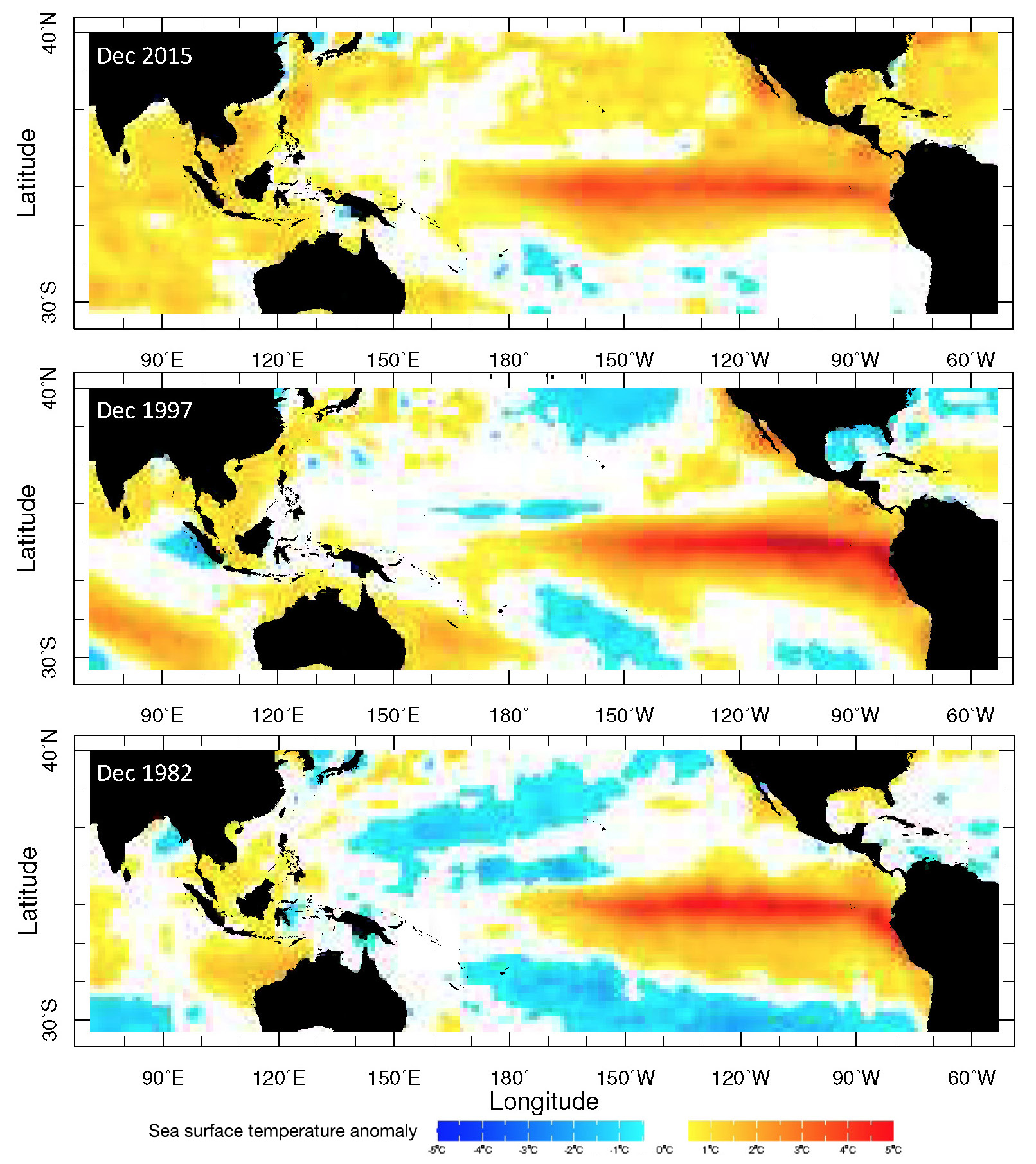
Figure 1: December sea surface temperature anomalies associated with 1982, 1997 and 2015 El Niño events. This figure shows the evolution of the spatial distribution of temperature anomalies across the Pacific Ocean over the past decades. Data from: iridl.ldeo.columbia.edu/SOURCES/.NOAA/.NCEP/.EMC/.CMB/.GLOBAL/.Reyn_SmithOIv2/ (Reynolds et al. 2002). |
The achievements of this workshop were the identification of a list of key questions that urgently need to be addressed (see Box 1 and Fig. 1). Most recent studies still differ on the factors that control trends in ENSO during the Holocene: stochastic processes, solar insolation, response to the mean climate conditions, or a combination of these factors (Cobb et al. 2013; McGregor et al. 2013). Temporal trends in ENSO variance differ and are site specific, highlighting the importance of mapping geographical patterns as well as producing single-site records. Similarly, projected future changes in ENSO are model dependent (Collins et al. 2010). Advances in analytical precision and novel geochemical tools that have recently been developed provide a new impetus to address these research questions. We propose a road map to make progress on these research questions.
• Improve our understanding of the interactions between ENSO and other modes of variability, including the Indian Ocean Dipole and the East Asian Monsoon.
• Increase the temporal coverage to fully explore the response of ENSO to different mean background states (Last Glacial Maximum, Felis et al. 2012; previous interglacials; Pliocene).
• Reconstruct changes in the spatial patterns of ENSO (Fig. 1), which requires a denser coverage of proxy dataset (Freund et al. 2019).
• Build a global multi-archive database of interannual climate variability using a common metric. For this we need to homogenize methods for quantifying ENSO variance.
affiliationS
1Université de Nantes, Laboratoire de Planétologie et Géodynamique, France
2Research Center for Geotechnology, Indonesian Institute of Sciences (LIPI), Bandung, Indonesia
3Research School of Earth Sciences, Australian National University, Canberra, Australia
4ARC Centre of Excellence for Climate Extremes, Australian National University, Canberra, Australia
5MARUM – Center for Marine Environmental Sciences, University of Bremen, Germany
6School of Earth Atmosphere and Earth Sciences, Wollongong University, Australia
contact
Mary Elliot: mary.elliotuniv-nantes.fr
references
Cobb KM et al. (2013) Science: 339: 67-70
Collins M et al. (2010) Nat Geosci 3: 391-397
Emile-Geay J et al. (2020) In: McPhaden MJ et al. (Eds) El Niño Southern Oscillation in a Changing Climate. Wiley, ch. 5
Felis T et al. (2012) Nat Commun 3: 965
Freund MB et al. (2019) Nat Geosci 12: 450-455
McGregor HV et al. (2013) Nat Geosci 6: 969-953
Yassine Ait Brahim1, J. Hu2, J. Baker1, C. Perez-Mejias1, H. Zhang1 and L. Comas-Bru3
4th SISAL workshop, Xi'an, China, 14-18 October 2019
The SISAL working group (Speleothem Isotope Synthesis and Analysis; pastglobalchanges.org/sisal) dedicated its initial phase to creating and maintaining a database of worldwide speleothem δ18O and δ13C records. The first version of the database (Atsawawaranunt et al. 2018a) contained 381 speleothem records and was published in 2018 (Atsawawaranunt et al. 2018b). An expansion of the database (SISALv1b; Atsawawaranunt et al. 2019) increased that number to 456 records from 211 sites (Comas-Bru et al. 2019). Thanks to the efforts of SISAL's committed members, the second version of the database (SISALv2), containing 691 records, will be made available in 2020.
Twenty-seven SISAL members (including 22 early-career researchers and 13 female researchers) from 12 countries gathered at Jiaotong University in Xi'an, China, for the fourth SISAL workshop (pastglobalchanges.org/calendar/2019/127-pages/1942). The main goals of this meeting were to finalize ongoing tasks related to the construction of SISALv2, attempt to resolve research questions by improving data-model comparisons through SISALv2, host a training session on database utilization and analysis, and finally to discuss and organize prospective projects under SISAL.
 |
|
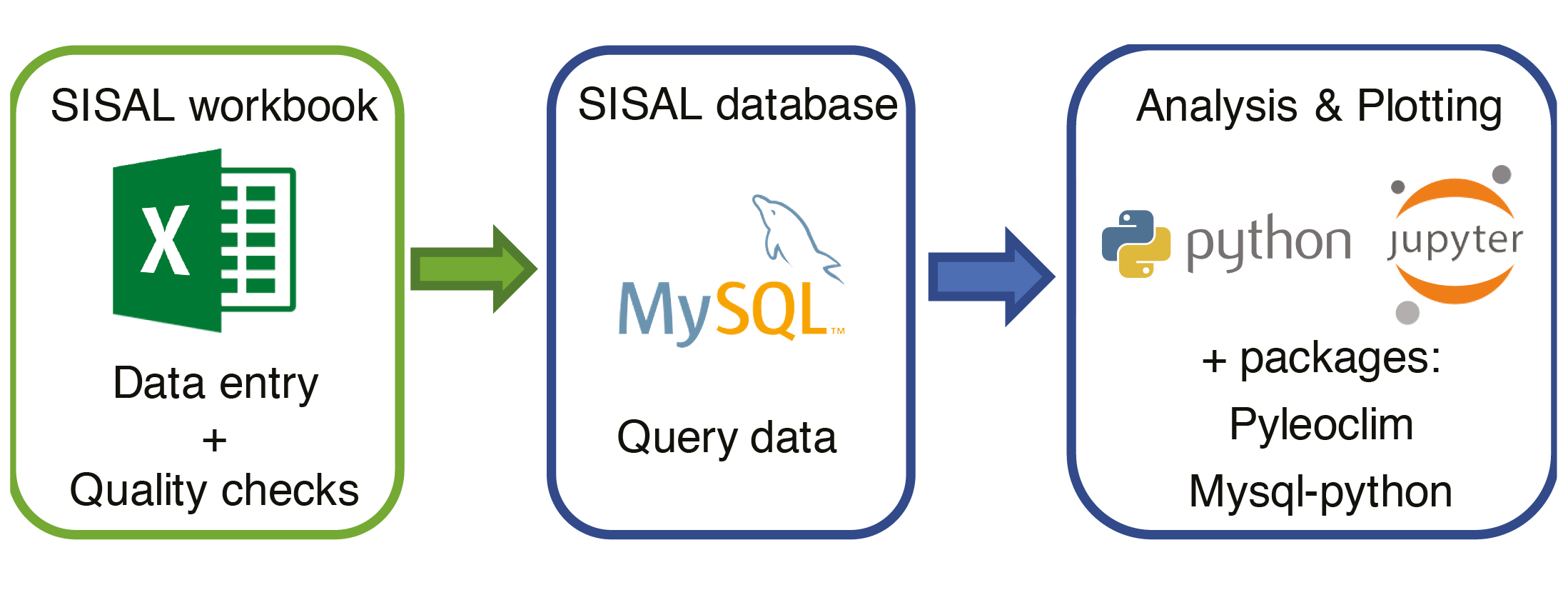
Figure 1: The workflow of the training sessions. Three main tasks are data entry and quality checks of SISAL workbooks; querying data from SISAL database; and plotting/conducting analyses using the database. |
The workshop kicked off with a visit to the archaeological site of the Terracotta Warriors and Horses and the Lantian loess field, 35 km east of Xi'an. During the evening, invited speakers gave presentations about multiscale climate variability in Iberia (Dr. Ana Moreno), multiscale climate variability in South America (Prof. Francisco W. Cruz) and advancements on the application of fluid inclusions in speleothems (Dr. Hubert Vonhof).
On the morning of day two, the lead coordinator of SISAL (Dr. Laia Comas-Bru) provided an overview on the progress of SISAL and its ongoing activities. Afterwards, selected participants presented their work on regional climate patterns inferred from speleothems, as published in our Quaternary special issue on "Speleothem Records and Climate" (Harrison and Comas-Bru 2019). During the afternoon session, presentations focused on isotope-enabled climate models and data-model comparisons. The day closed with local researchers presenting their own speleothem-based research.
On days three and four, the workshop was structured as a mixture of training and analysis sessions. The analysis stream took advantage of the balanced representation of speleothem researchers and climate modelers present at the workshop to design new hypotheses, which could be addressed using the new version of the SISAL database and currently available isotope-enabled climate models. Participants divided into three breakout groups focused on individual time periods and/or climate events to identify analyses that could be of interest to the Palaeoclimate Modelling Intercomparison Project (PMIP) community. Additionally, some attendees worked on a handbook for reporting speleothem isotope records, drawing from experience gathered by the SISAL initiative. The training stream was open to anyone interested, with the aim to teach researchers how to use the SISAL database. Participants had the opportunity to learn how to fill in SISAL workbooks and run quality-control scripts to check their consistency and readiness to be uploaded to the database. Participants were given a basic introduction on the structure of the SISAL database and the most common MySQL commands needed to extract data from the database. In addition, tutors illustrated how to read, plot, and carry out analyses using the SISAL database. The examples included plotting multiple speleothem timeseries with age error bars, plotting a map of pre-filtered sites, applying low-pass filtering, and conducting correlation and spectral analysis. The training stream is among the new initiatives taken by SISAL, and the group intends to run similar sessions at other conferences such as KR9 (uibk.ac.at/congress/kr9/scientific-programme/workshops.html).
Acknowledgements
We thank the hosts, Prof. Hai Cheng, and all the students of XJTU Isotope Laboratory who ensured that everything ran smoothly during the workshop. Organizers would also like to thank PAGES, National Natural Science Foundation of China (project number: NSFC 41888101 and 41942012), and Xi'an Jiaotong University for their financial support.
affiliationS
1Xi'an Jiatong University, China
2Rice University, Houston, TX, USA
3University of Reading, UK
contact
Yassine Ait Brahim: aitbrahimxjtu.edu.cn
references
Atsawawaranunt K et al. (2018a) SISAL database Version 1.0. University of Reading. Dataset
Atsawawaranunt K et al. (2018b) Earth Syst Sci Data 10: 1687-1713
Atsawawaranunt K et al. (2019) SISAL database Version 1b. University of Reading. Dataset
Comas-Bru L et al. (2019) Clim Past 15: 1557–1579
Harrison SP, Comas-Bru L (Eds) (2019) Quaternary (special issue) Speleothem Records and Climate
Sarah Ivory1, A.-M. Lézine2, E. Grimm3 and J.W. Williams4
Paris, France, 13-16 October 2019
African ecosystems hold enormous ecological and economic value due to high biodiversity (Myers et al. 2000) and valuable ecosystem services provided to urban and agrarian populations (Wangai et al. 2016). However, these services are vulnerable to land use and climate change (Niang et al. 2014). Long paleoecological records from Africa provide iconic examples of abrupt environmental change, offering critical evidence for tipping points in the Earth system. Datasets in the region are notoriously difficult to access with the African Pollen Database (APD) largely unsupported for the last decade. Poor data accessibility has been a community complaint.
Hosted by the Institut de Recherche pour le Développement in Paris, France, 32 participants from 12 countries met to revive efforts by the African paleoecology community and relaunch the APD as a community curated data resource (Williams et al. 2018). This workshop was organized by the LOCEAN and funded by the Belmont Forum for Science-driven e-Infrastructure Innovation project "Abrupt Change in Climate and Ecosystems: Where are the Tipping Points?" The Belmont e-infrastructure initiative seeks to enhance open, FAIR, scientific cyberinfrastructure (Wilkinson et al. 2016) to meet pressing, policy-relevant challenges.
 |
|
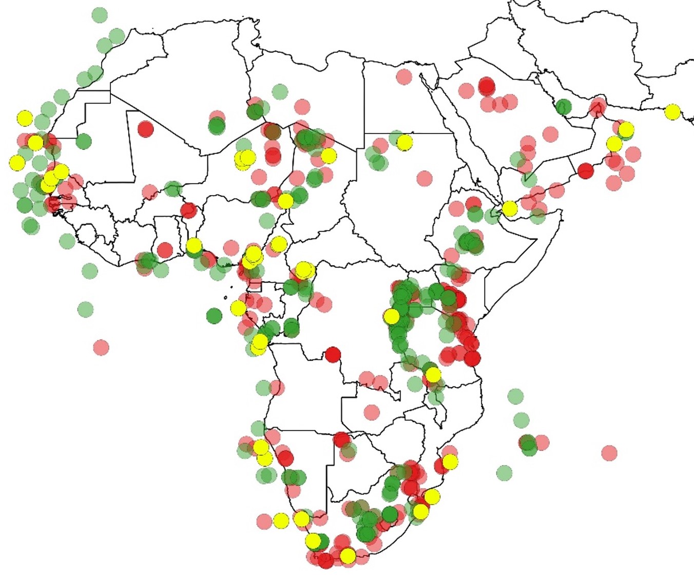
Figure 1: Paleoecological sites within the APD (green), datasets obtained but not yet within the APD (yellow), and known datasets not currently contributed to the APD (red dots). Northern Africa is in the European Pollen Database. |
African Pollen Database: History and plan
The APD was first developed in 1996. The initial workshop and subsequent work, funded by the French CNRS, the EU (INCO, ENRICH) and UNESCO (PICG), established methods of collating pollen data, developed a standardized pollen nomenclature (Vincens et al. 2007), generated updated age models, collated images of pollen grains, and created a searchable web interface. Currently, the APD contains 288 fossil sites and 1985 modern samples. Due to a lack of funding and the closure of the French data center, Medias-France, the APD lapsed in 2007, making its extant data holdings largely inaccessible and leaving no home for newer paleoecological records.
Workshop participants identified three critical elements of the APD: (1) Pollen samples with associated chronological controls and other metadata; (2) Standardized taxonomy for pollen morphotypes; and (3) Pollen grain images. Participants developed a two-pronged plan for rebuilding these APD components. The APD webpage will be relaunched, in collaboration with LSCE (IPSL, France) to meet region-specific needs, including modern and paleo data, taxonomy development, and hosting of pollen images. Further, APD data will become a constituent database of the Neotoma Paleoecology Database (Goring et al. 2015), an international community-curated data resource that meets FAIR standards and is registered with ICSU-WDS and COPDESS. Planning began for a data steward training workshop in Amsterdam in January 2020 to begin uploading pollen data to APD/Neotoma. The participants saw value in these combined efforts for assuring the longevity of a living, community-curated APD data resource.
Building a community
Africa was divided into six sub-regions (Central, Southern, East, West, Arabia, Madagascar/Indian Ocean Islands, and marine), and regional experts identified records produced post-2007 and legacy datasets not included in the APD. The increase in research in Madagascar and Central Africa was notable, given prior underrepresentation of these regions. Specialists reported 365 known sites not in the APD, ranging in age from 1000 years to the Plio-Pleistocene. Modern samples (1985 entries) are also available, with more to be added. Some modern samples were collected as early as 1954 and should be used with caution to represent modern vegetation. In sum, these sites include a wealth of new information: marine and terrestrial, from diverse archives, many of which are well-dated with high temporal resolution. This will facilitate the burgeoning number of new studies and spatio-temporal meta-analysis of ecosystem-climate linkages, closing the gap with other regions.
Further, a governance body was launched, co-led by Sarah Ivory and Anne-Marie Lézine, with multiple scientists volunteering to serve as representatives and data stewards from each region. As the APD council is launched, an effort is being made to balance the numbers of African and non-African scientists as well as early-career scientists. Through representation within the APD and improved access to open data resources and software, we hope to build opportunities for young researchers from Africa.
affiliationS
1Department of Geosciences, Pennsylvania State University, University Park, USA
2Laboratoire d’Océanographie et du Climat expérimentations et modélisations numériques (LOCEAN), CNRS, Paris, France
3Department of Earth and Environmental Sciences, University of Minnesota, Minneapolis, USA
4Department of Geography, University of Wisconsin, Madison, USA
contact
Sarah Ivory: sji15psu.edu
references
Goring S et al. (2015) Open Quat 1: p.Art. 2
Myers N et al. (2000) Nature 403: 853-858
Vincens A et al. (2007) Rev Palaeobot Palyn 145: 135-141
Wangai PW et al. (2016) Int J Sustain Built Environ 5: 225-245
Alvaro Castilla-Beltrán1,2, H. Hooghiemstra3, M.L.P. Hoogland1, J. Pagán-Jiménez1, B. van Geel3, M.H. Field1, M. Prins4, T. Donders5, E. Herrera Malatesta1,6, J. Ulloa Hung1, C.H. McMichael3, W.D. Gosling3 and C.L. Hofman1
Shortly after Columbus' landing in the New World in 1492 CE, indigenous land use diminished and cattle grazing was introduced. Large-scale agriculture in the Cibao Valley, northern Dominican Republic, did not develop before the 17th century. Here, we read the environmental history of the Cibao Valley from two sediment cores.
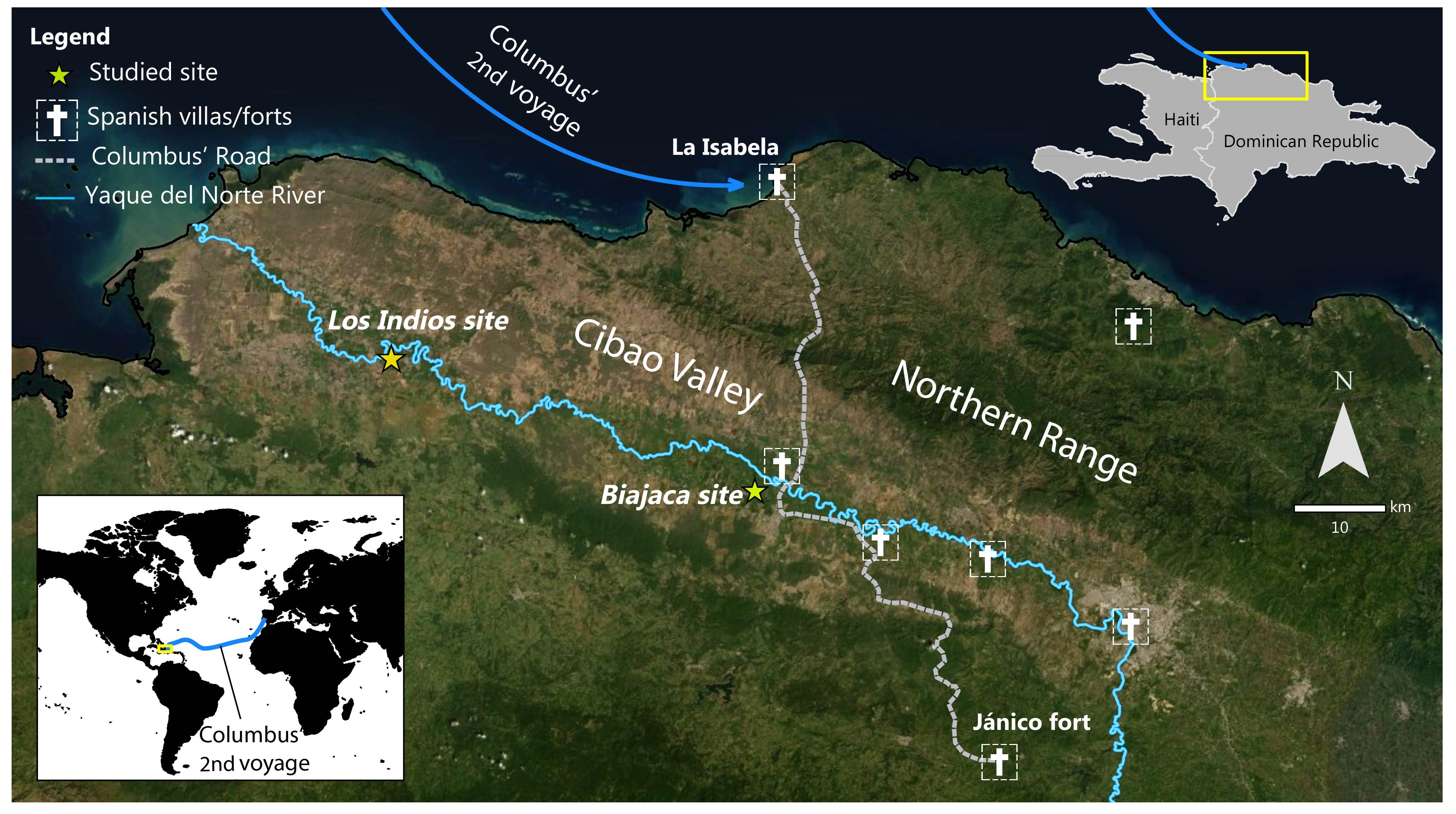
In 1492 CE Columbus landed in the "New World". In 1494 CE he founded La Isabella, the first colonial town in the Americas, located at the northern coast of the current Dominican Republic (Haytí island; Fig. 1; Ortega 1988). Five hundred years of colonial exploitation followed, which had far-reaching impacts for the indigenous people and local landscapes (Hofman et al. 2014; Siegel et al. 2015). Paleoecological analyses of sediment cores collected in sediment-filled meanders of the Yaque del Norte River (Cibao Valley) show the regional environmental history. Pre-Columbian indigenous land use had an impact on the forests of the valley. Depopulation due to post-contact epidemics and warfare was a major driver of dramatic landscape change.
 |
|
Figure 1: Map of Cibao Valley and the Yaque River in the northern Dominican Republic, Caribbean archipelago. "Haytí island", later called "Hispaniola" by the European colonists, today includes Haiti and the Dominican Republic. |
Sources of information
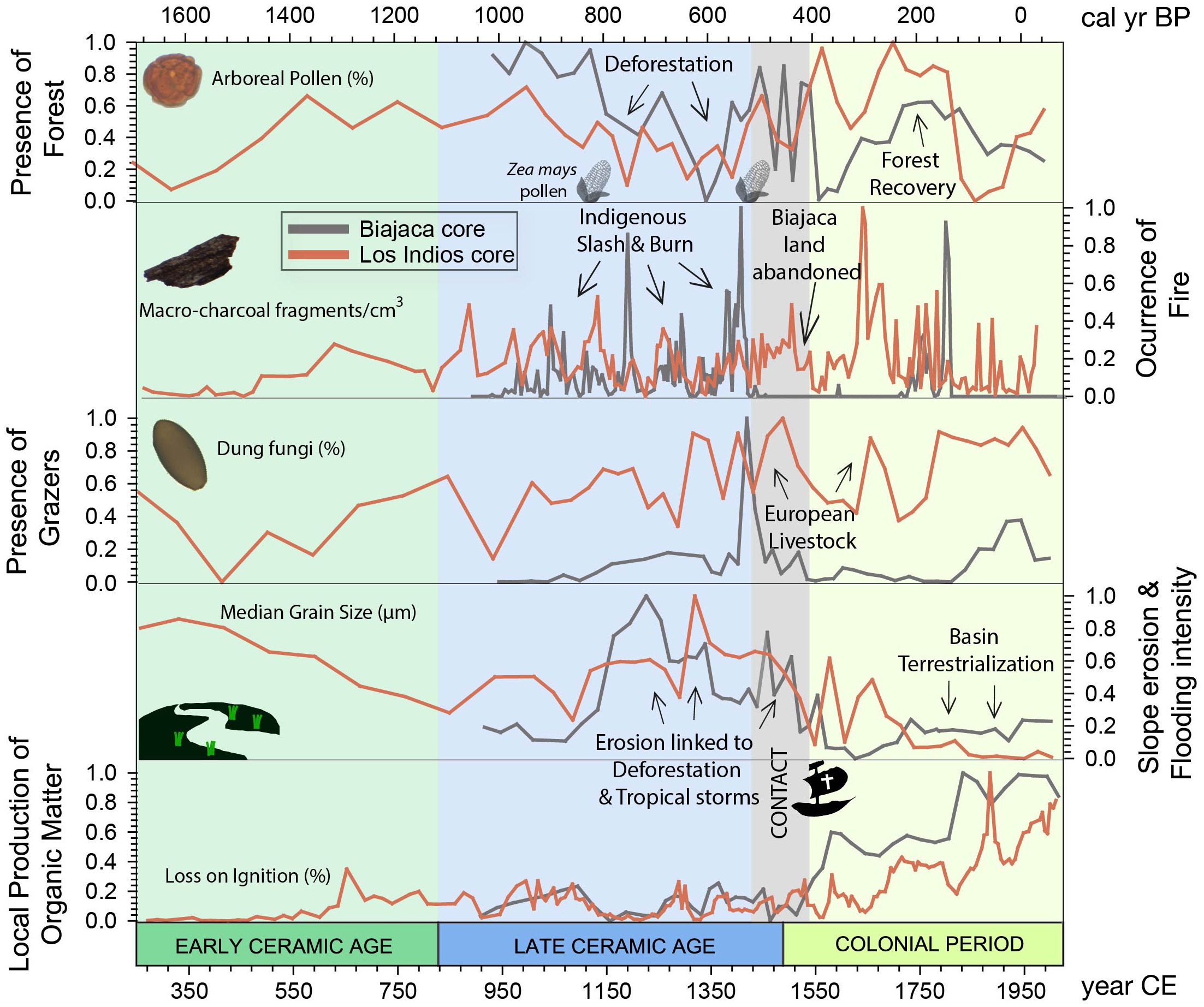
Changes in land use were studied from various threads of paleoecological evidence. Organic matter was radiocarbon-dated and provided a time scale for the sediment column. The records of fossil arboreal and herbaceous pollen and phytoliths (silica structures occurring in plant cells characteristic of specific groups of plants) show terrestrial vegetation changes. Non-pollen palynomorphs (e.g. spores of coprophilous fungi) are indicative of land-use changes, as they provide evidence of the presence of big mammals, and these changes in abundance are indicative of the introduction of European cattle. The record of charcoal documents the fire history (increased fire ocurrence indicates deforestation to develop agriculture) and the plant macrofossils show the composition of local wetland vegetation. Grain size analysis shows the changing energy levels of the river (coarse-grained silt and sand reflects intense flooding and fine-grained clay standing water) and the proportion of organic matter in the sediments reflects the abundance of aquatic vegetation. Fossil pollen of food plants and phytoliths show which food plants have been grown through time. All these threads of evidence come together to reveal a detailed account of how people have interacted with the landscape during the last 1800 years (Fig. 2).
The sediment core from site Biajaca reflects the last 1100 years (see Castilla-Beltrán et al. 2018). Biajaca is centrally located in the Cibao Valley ca. one kilometer away from the Columbus Route (Ruta de Colón), connecting the northern coast with the mountainous interior. This first informal "road" in the New World allowed for the transportation of gold and other products. At a kilometer distance from Biajaca, there is an archaeological site of an indigenous settlement. The sediment core from site Los Indios, some 40 km to the west, shows the last 1800 years (see Hooghiemstra et al. 2018). Both records together show a fascinating view of human activities before and after European incursion in the Americas.
Pre-Columbian landscape changes
The translocation of continental domestic plants, such as maize, chilli pepper, and sweet potato was a process that started from the first peopling of the Caribbean, around 7800 years ago (Pagán-Jiménez et al. 2015). In two later main pulses of migration, around 3500 and 500 BCE, the islands of the archipelago were populated by indigenous communities (Hofman et al. 2018). Until ca. 1400 CE, human impact on the environment of the studied area consisted of slash-and-burn practices to open areas for the cultivation of crops such as maize (Zea mays) and squash. This is evidenced by sustained charcoal deposition and the presence of pollen and phytoliths of these cultivars in the Biajaca record. Settlements were probably distributed in a mosaic structure, leaving relatively little disturbed forest on the floor of the Yaque River.
 |
|
Figure 2: Paleoenvironmental change, Cibao Valley (Dominican Republic): multiple lines of evidence from the Biajaca and Los Indios sediment cores. Measured values have been normalized (varying between 1 and 0). The records show the last ca. 1800 years of landscape and land-use changes in the Cibao Valley. |
The impacts of European colonization
The period from 1450 CE to ca. 1650 CE shows increasing human impact on the landscape. Columbus encountered a relatively densely populated valley with agricultural production on mounds and river terraces. Introduced European diseases decimated the indigenous population (Koch et al. 2019). This is evidenced by the absence of charcoal deposition at the Biajaca record and in the forest regrowth in both records. First colonists introduced cattle from the Iberian Peninsula; this is shown by more abundant spores from coprophilous fungi in a more open landscape. The island was becoming a hub for further exploration and occupation of the Caribbean and Central America, and chronicles report an intense conflict between Spanish colonizers and indigenous people (Hofman et al. 2018). At the same time, enslaved people from Africa were brought to the island. Ruderal plants (Artemisia, Plantago, and representatives of the Boraginaceae, Polygalaceae, and Brassicaceae families) are indicative of ecological succession in abandoned agricultural fields and cleared forest plots. Introduced taxa from the Old World, such as Rubus, also appear in the pollen record.
Near the middle of the 16th and 17th centuries, the charcoal record shows an increase in fire, reflecting forest clearance in the surroundings of the Los Indios site (western Cibao Valley) and near the site Biajaca (along the Columbus Road) respectively. Aquatic vegetation started to develop, indicating that the meanders were isolated from the drainage system. More abundant organic matter accumulated in the oxbow lakes. The establishment of Typha, Sparganium, and Cyperaceae plants reflects local terrestrialization at the sampling site. A plethora of changes, such as increasing fire, deforestation, loss of arboreal taxa, and the appearance of cultivated plants (banana, and solanaceous plants, potentially including chili pepper and tobacco, which we currently cannot identify to the species level) reflect the introduction of monocultures on a large scale in the Cibao Valley. After independence in 1844 CE, forest remnants were burned and charcoal deposition gradually decreased. Today, plantations of banana and rice dominate in the Cibao Valley.
Significance
"Reading" the environmental information deposited in two sediment-filled meanders near the Columbus Route yielded new information about how indigenous people used the landscape in pre-Columbian times. Indigenous land use changed dramatically after 1492 CE. Colonizers immediately introduced cattle farming, and depopulation caused forest regrowth.
Some 150 years later, abundant use of fire deforested the Cibao Valley, and large-scale agriculture was developed to serve European and local markets. From the moment of independence of the Dominican Republic, this valley became an agricultural center and was largely cleared of forests. Proxy-specific reconstructions can uncover many details, and a multi-proxy synthesis shows how the landscapes of the island developed into the ones we see today. Understanding these historical developments is essential to better appreciate successive steps in human-driven environmental degradation in this Caribbean island from pre-Columbian times.
Acknowledgements
This research was funded by the Synergy NEXUS1492 project financed by the European Research Council under the European Union's Seventh Framework Programme (FP7/2007-2013) grant agreement 319209 directed by professor Corinne L. Hofman, Faculty of Archaeology, Leiden University, The Netherlands.
affiliations
1Faculty of Archaeology, Leiden University, The Netherlands
2School of Geography and Environmental Science, University of Southhampton, UK
3Department of Ecosystem and Landscape Dynamics, University of Amsterdam, The Netherlands
4Department of Earth Sciences, Vrije Universiteit, Amsterdam, The Netherlands
5Department of Physical Geography, Utrecht University, The Netherlands
6Lorentz Center, Leiden, The Netherlands
contact
Alvaro Castilla-Beltrán: a.castilla-beltransoton.ac.uk
Corinne Hofman: c.l.hofmanarch.leidenuniv.nl
references
Castilla-Beltrán A et al. (2018) Anthropocene 22: 66-80
Hofman C et al. (2014) World Archaeol 46: 590-609
Hofman C et al. (2018) Antiquity 92: 200-216
Hooghiemstra H et al. (2018) Holocene 28: 1818-1835
Koch A et al. (2019) Quat Sci Rev 207: 13-36
Ortega EJ (1988) La Isabela y la Arqueología en la Ruta de Colón. Editorial Universidad Central del Este, 100 pp
Fausto O. Sarmiento1, M.B. Bush2, W. Church3, P. VanValkenburgh4, M. Oliva5, E. Delgado5, S. Fernandez5 and N. Rojas5
We seek to highlight how paleoecology, archaeology, and geoecology can add to the repertoires of ecotourism guides in Peru's Chachapoya region, providing informed portraits of the history of cloud forest ecology in Peru's northeastern Andes and raising concerns about the future conservation of these mountainscapes under human impact.
The eastern slopes of the Andes are underexplored and underexploited from the perspective of ecotourism. In the northern region of Chachapoyas (Fig. 1), where we have focused recent research, phenomenal biodiversity and pre-Hispanic cultural diversity are present in such proximity to each other that an ecotourist spending seven to 10 days on a single visit might encounter everything from mummies to marsupials. Biological and cultural diversity in these tropical montane cloud forests (TMCFs) have been, and continue to be, shaped by climate change; but scientists have largely missed the opportunity to engage guides and tourists, and to enrich their narratives and experiences while informing them on matters of montane conservation concern.
New research initiatives are improving our understanding of linkages between climate oscillations and how past human activities influenced modern trajectories of succession and community composition in Chachapoyas. Mountain geographers are now collaborating with paleoecologists and archaeologists to explore the origins of Anthropocene landscapes in the tropical Andes (Bush et al. 2015; Guengerich and Berquist 2020).
Cloud forests as a transformed landscape
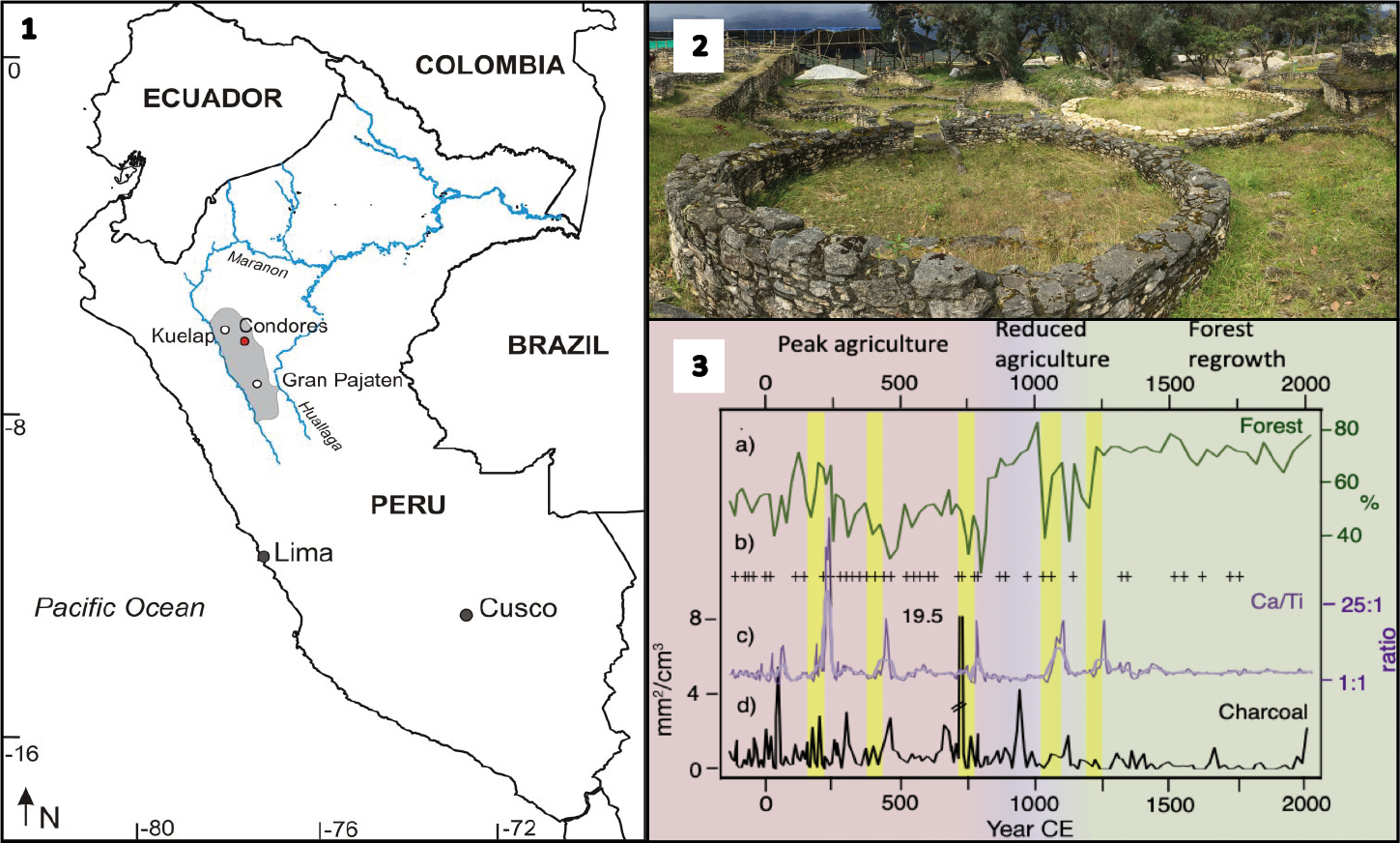
Until recently, the Andean-Amazon slopes were considered remote and inaccessible; a primordial wilderness. We now know that humans arriving by the end of the Pleistocene probably contributed to the extinction of megafauna (Raczka et al. 2018), and initiated 12,000 years of landscape domestication both deliberately and unintentionally, which varied in intensity through time and across space (Young 2009; Guengerich 2015). By the late Holocene, the Chachapoyas socioecological system had generated dense clusters of complex agricultural societies built atop heavily modified mountain landscapes, and became a trade crossroads. Valley systems provided natural east-west conduits and became foci of settlements (Åkesson et al. 2020; Church and von Hagen 2008; Lara 2010).
 |
|
Figure 1: The Chachapoyan region. (1) Sketchmap showing the Chachapoyan region (grey shaded area), (2) Chachapoya house remains at Kuelap, (3) megadroughts (yellow bars from the Laguna de los Cóndores record): (A) percentage of forest pollen, (B) samples where maize pollen was recovered, (C) Ca/Ti ratio from XRF data as a proxy for drought, (D) charcoal as a proxy for human-induced fire. Modified from Åkesson et al. (2020). |
Between ca. 1200 CE and 1400 CE, a cultural tradition with shared attributes, including some elements of architectural and ceramic style, reached its peak across a settled area of ca. 30,000 km2 (Schjellerup 2019). Termed "Chachapoyas culture" by archaeologists, the Inka first referred to the region as the "land of the people of the clouds" or sachapuyu, and this Kichwa name appears on the earliest colonial documents. A combination of demographic collapse, social disintegration, and lack of interest in the native cultures shown by Spanish colonists rapidly eliminated cultural knowledge, leaving the task of reconstruction to historical geographers, landscape archaeologists, historical ecologists and paleoecologists.
This is where new data on climate change are revealing unexpected patterns. Intense droughts immediately conjure images of hardship – possibly even landscape abandonment. But in these very wet settings, those droughts appear to have fueled agricultural incursions into cloud forest (Åkesson et al. 2020). Portions of the landscape were cleared for maize cultivation until wet conditions returned. Thus, the more accessible the cloud forest, the more likely it was to have supported past human activities. In large part, the factors that make a modern valley or ridge accessible to ecotourists also made it a usable space for past cultivators. Consequently, the areas that tourists can readily access today are very likely to have long histories of intensive land use, dating to pre-Columbian times (Sarmiento 2012) constituting de facto biocultural microrefugia.
Cross-cutting science for montological studies
Montology is the transdisciplinary science of mountains, where current geoecological knowledge, paleoecological insights, and archaeological studies in the region's TMCFs now complement one another. Pollen data obtained from lakes tell stories of climate extremes beyond our modern experience, both wet and dry, against a backdrop of long-term change. Pollen records collected from Lake Pomacochas (Bush et al. 2015) and Laguna de los Cóndores indicate millennia of maize cultivation, demographic and subsistence shifts, and ecological turnover before the Spanish invasion of 1532-35 CE (Matthews-Bird et al. 2017). Within the last 1000 years, as regional climates became wetter, some locations show forest recovery apparently at the expense of cultivated lands, perhaps as land-use strategies have shifted toward exploiting drier slopes, the net effect of which was widespread forest recovery. Within the last 500 years, the Inka incorporation followed by the Spanish invasion and subsequent colonization, including the effects of epidemic diseases, decimated local cultures, and concentrated inhabitants in readily controlled centers of occupation, further emptying the forests of inhabitants. During the 20th century, accelerating population growth and enhanced accessibility have ignited new efforts to conquer the "wilderness" and resume landscape domestication (Schjellerup et al. 2005).
Another realization is that many TMCF Andean habitats that were long thought to be "natural" are now seen as having long histories of human modification or "engineered" landscapes, and that a reconsideration of their resilience to climate change is needed (Sarmiento 2016). Because fire was a part of past land management, it would have influenced survival rates and increased edge effects on unburned areas. The hunting pressure from cultivation-based communities would have also reduced the population of game animals and disproportionately removed large seed-dispersers (Aubad et al. 2010). Favored plants might have been tended to, planted, or even accidentally introduced, even at some distance from villages. Consequently, when the forests regrew, they would have been on a different successional trajectory than in an undisturbed setting (Levis et al. 2012). While species compositions changed, so too did the physical landscape, as hill slopes were modified by either earthen terracing or stream canalization.
Modern trade has accelerated landscape transformation and introduced many exotic species to the region, including African grasses, Australian Eucalyptus, and Monterrey pine. Consequently, these forests, which exist as a full gradient from "novel" communities to nearly natural ones, will respond differently to climate stimuli than their natural counterparts. Stimuli also come from the socio-ecological systems in need of applied montology (Sarmiento et al. 2017) and better conservation approaches (Bax and Francesconi 2019) to sustainability.
 |
|
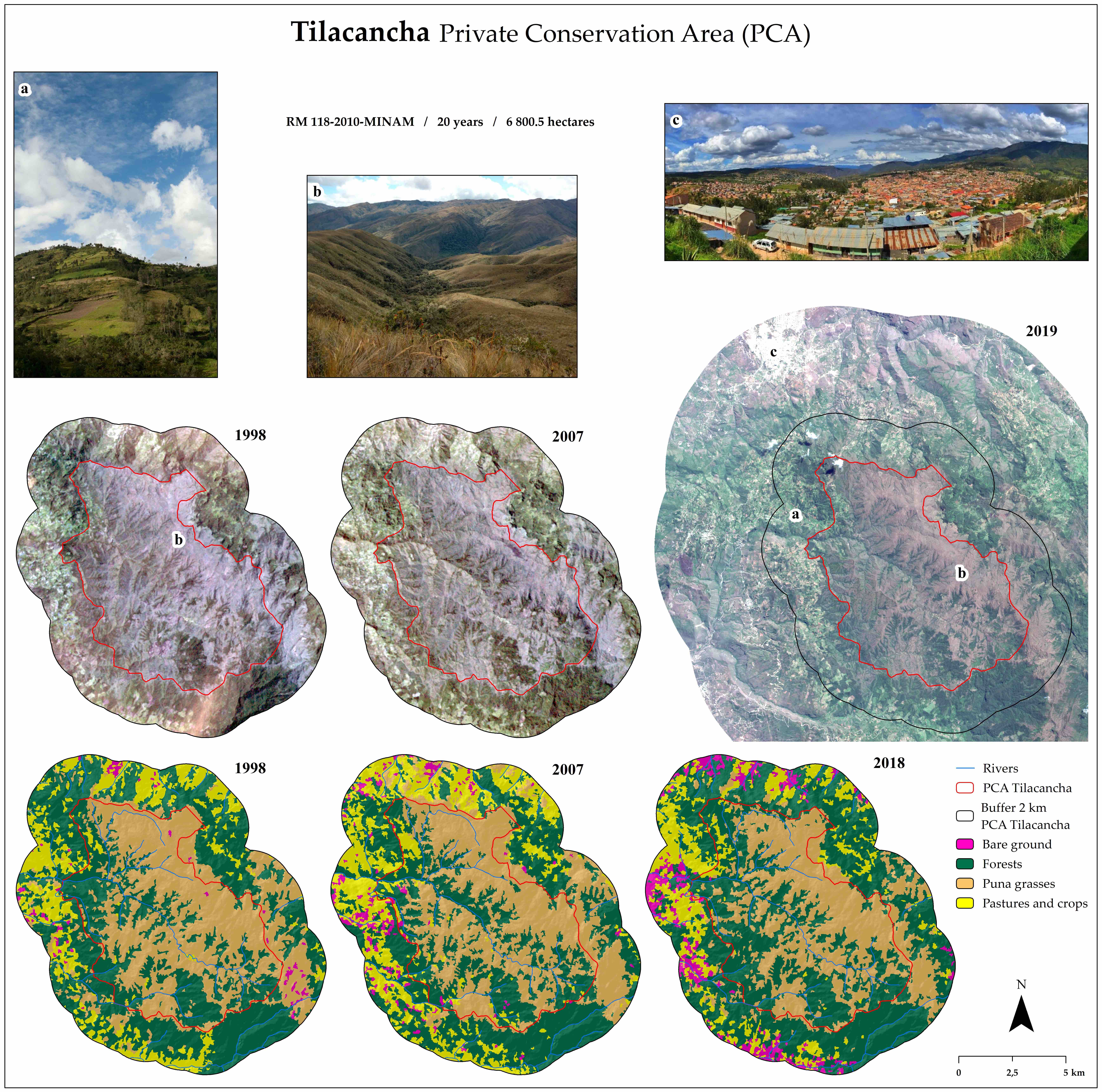
Figure 2: Infographic of Tilacancha in Chachapoyas. Source: N. Rojas, Landsat 5 images, Path/Row 009/064, 11/28/1998 and 08/01/2007 (USGS, earthexplorer.usgs.gov). Sentinel 2A image, Path/Row 17MRP, 08/17/2019 (ESA, earthexplorer.usgs.gov). Photos (A) Conservamos por Naturaleza, Peruvian Society of Environmental Law. (B) Roque Silloa. (C) Mirador de Luya Urco (CieloChicBlog, cielochicblog.com/?p=2809). Maps of land cover and land use: E. Delgado. Photos compiled by S. Fernandez and N. Rojas. |
The path to science-based ecotourism
Today, conservation efforts are developing strategies of payment for environmental services and preservation of remnant old-growth forests in protected national, district-level or private areas. For example, among the perceived benefits of restoration of the privately held Tilacancha and Huiquilla Conservation Areas (Fig. 2) are improved water quality, prevention of mining operations that despoil landscapes, and promotion of ecotourism. These mixed-use areas still support exotic Eucalyptus and Pinus plantations, but the restricted use of fire now allows degraded pastures to return to forest. An increase in wildlife has already been observed, and ecotourism is incentivized by the role of informed guides trained via environmental education campaigns and ecotourism investment opportunities. Indeed, the most profitable conservation option is tourism, and many investments emphasize ecotourism ventures, such as "the route of petroglyphs", "the route of mummies", and "waterfall circuits" featuring one of Peru's tallest waterfalls (Gocta), a spectacular hilltop citadel (Kuelap), and impressive mortuary sites such as the sarcophagi of Karajia and the mausoleums at Revash. Together, they create a vibrant touristic destination of "natural" and "cultural" sites that may one day may rival the Sacred Valley near Cuzco, if properly encouraged.
We argue that the only way to maintain the unique characteristics that draw ecotourists to an area is to curate the biocultural heritage and to seek to apply regenerative development strategies that confer additional resilience to landscapes in the face of the expansion of cattle grazing. We could start with restoring degraded slopes and reforesting large areas that could bring back the former TMCF, including iconic animals that attract ecotourists, such as Peru's national bird, the cock-of-the-rock (Rupicola peruviana), the spectacled bear (Tremarctos ornatus), the spatula-tailed hummingbird (Loddigesia mirabilis), the mountain lion (Puma concolor), the critically endangered yellow-tailed wooly monkey (Oreonax flavicauda) and the long whiskered owlet (Xenoglaux loweryi). Such protections require not only trained guides but also changes in management strategies by owners, as well as an about-face in popular consciousness to curve destruction of the "Ceja de Selva".
Effective management can be informed by natural fire periodicities of >1000 years elicited from paleoecological records and lists of taxa that should form the basis for replanting in both natural and civic settings. It is imperative that the modernization efforts encourage tourists to spend time in the city of Chachapoyas, where old native trees of the plazas have been replaced by newly planted exotic species. But perhaps one of the most valuable roles that mountain science can play is by informing the narratives and anecdotes that provide local insights and environmental appeal to the descriptions given by science-trained guides. They must provide information from montology that is accurate, enriching, and deepens the understanding of how our history shapes what we perceive to be natural in the biocultural microrefugia of the tropical Andes.
affiliations
1Neotropical Montology Collaboratory, Department of Geography, University of Georgia, Athens, USA
2Neotropical Paleoecology Research Group, Harris Center for Science and Engineering, Florida Institute of Technology, Melbourne, USA
3Department of Earth and Space Sciences, Columbus State University, GA, USA
4Department of Anthropology, Brown University, Providence, RI, USA
5Instituto de Investigaciones de Desarrollo Sustentable de la Ceja de Selva, Universidad Nacional Toribio Rodríguez de Mendoza de Amazonas, Chachapoyas, Peru
contact
Fausto Sarmiento: fsarmienuga.edu
references
Åkesson CM et al. (2020) Nat Ecol Evol 4: 66-74
Aubad J et al. (2010) Acta Oecol 36: 396-402
Bax V, Francesconi W (2019) J Environ Manage 232: 387-396
Bush MB et al. (2015) Holocene 25: 1522-1532
Guengerich A, Berquist S (2020) Journal of Field Archaeology 45: 153-169
Guengerich A (2015) Latin American Antiquity 26: 362-381
Lara CI (2010) Antropología Cuadernos de Investigación 9: 77-90
Levis C et al. (2012) PLoS ONE 7: e48559
Matthews-Bird F et al. (2017) Holocene 27: 1707-1719
Raczka MF et al. (2018) Quat Sci Rev 205: 154-165
Sarmiento FO (2012) Contesting Páramo: Critical Biogeography of the Northern Andean Highlands. Kona Publishing, 200 pp
Sarmiento FO (2016) Engineering Mountain Landscapes: An Anthropology of Social Investment. American Indian Culture and Research Journal 40: 157-159
Sarmiento FO et al. (2017) Ann Assoc Am Geogr 107: 416-428
Schjellerup IR (2019) Acta Archaeologica 90: 135-154
Schjellerup IR et al. (2005) The Chilchos Valley revisited: Life conditions in the Ceja de Selva, Peru. The National Museum of Denmark, 424 pp