PAGES Magazine articles
José María Fernández-Palacios1, S. Nogué2,3, C. Criado4, S. Connor5, C. Góis-Marques6,7, M. Sequeira6 and L. de Nascimento1
Past climate dynamics have helped shape the endemic ecosystems of Macaronesia. However, these insular ecosystems have since been modified following the arrival of human settlers, who had to adapt to the new environments and resources.
 |
|
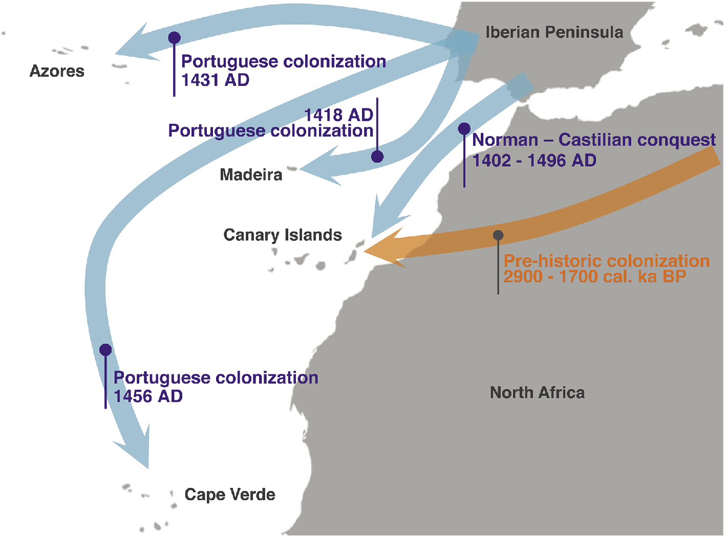
Figure 1: Human colonization of the islands of Macaronesia at prehistoric (orange arrow) and historical times (blue arrows). |
Macaronesia is a biogeographical region with four volcanic archipelagos (Azores, Madeira, Canaries and Cape Verde) in the NE Atlantic Ocean (Fig. 1). These island chains share several endemic genera and the three northernmost ones retain laurel forests, which are widely considered to be impoverished remnants of the Paleotropical Geoflora, distributed around the Tethys Sea during the Cenozoic, and disappeared at the onset of the Pleistocene glaciations.
Owing to their relatively late colonization by humans, oceanic islands offer the best conditions to disentangle the ecological impacts of human activities from those produced by climate shifts or volcanic events. Furthermore, Macaronesia comprises islands that were colonized either by North Africans (Canaries, ca. 2.9 ka BP; Atoche and Ramírez 2011) or later during the European expansion (Azores, Madeira and Cape Verde, 15th century; Fig. 1), allowing diverse cultural impacts to be differentiated. After their arrival, humans had to face and adapt to new environments and climatic conditions, which offered them new resources and provided new challenges.
Past climate change
The Canaries were subject to important climate change in the mid Holocene, namely the end of the African Humid Period, ca. 5.5 ka BP, which induced important shifts in the laurel forest composition, as the more hygrophilous taxa were displaced by more xerophilous ones (Nogué et al. 2013).
Paleoecological studies on Madeira Island are still rare, with the best contribution relating to the Piedade aeolian deposits (Goodfriend et al. 1996). An analysis of these deposits spanning the last 300 ka revealed changing plant cover through time, due to climate and sea-level shifts, as well as an abrupt change in vegetation following the arrival of the Portuguese.
On the Azores, paleoclimatic variations have been detected in sediments on Pico Island. Diatoms and geochemical indicators revealed several arid phases during the last 5000 years and an overall aridity trend linked to Atlantic sea-surface temperatures (Björck et al. 2006). However, vegetation on the Azores changed little in response to these climatic shifts (Connor et al. 2012).
Unfortunately, there are few paleoecological and paleoclimate studies in Cape Verde. Records from marine terraces, however, also point towards oceanic temperatures in this basin being warmer than the present ones during the Last Interglacial.
Human colonization, impact and adaptation
The trade winds are lifted by the Canarian mountains, creating a year-round humid zone which provides the laurel forest with a refugium to withstand the summer aridity of the Mediterranean climate. This humid zone, without analogue in North Africa during the Holocene, was an unknown environment for the arriving aborigines, where they found species offering new types of timber and fruits. Conversely, bronze or iron, known by early settlers, were not available in Macaronesia due to the volcanic origin of the islands; this led to a cultural decline to a level of the Stone Age (Atoche 2009).
During the pre-historic colonization, the aborigines introduced domestic species and used fire to clear forests and increase ecosystem productivity, hugely impacting the island biota that had evolved for more than 20 Ma in the absence of humans. Ecological impacts included extinctions of plant (de Nascimento et al. 2009) and vertebrate (Rando 2003) species, and ecosystem transformations (de Nascimento et al. 2016).
Recent paleoecological work has revealed significant clearance of vegetation around 2.3 ka BP that did not coincide with any known climatic shift or volcanic eruptions (de Nascimento et al. 2016), indicating that an aboriginal colonization of Gran Canaria must have taken place several centuries earlier than traditionally considered. We also know that there were forests in the highest parts of Fuerteventura, one of the driest islands in the Canaries, based on charcoal remains from trees used as firewood (Machado 2007) and fossil pollen records (de Nascimento, unpublished data). These forests formed under a more humid climate and have been able to subsist during the Late Holocene dry conditions (Yanes et al. 2011). After being cleared by aborigines, the much drier climate impeded the reestablishment of those forests, resulting in the extirpation of several species of trees (Machado 2007) and the loss of a strategic wood resource for future generations.
Changes following European settlement
 |
|
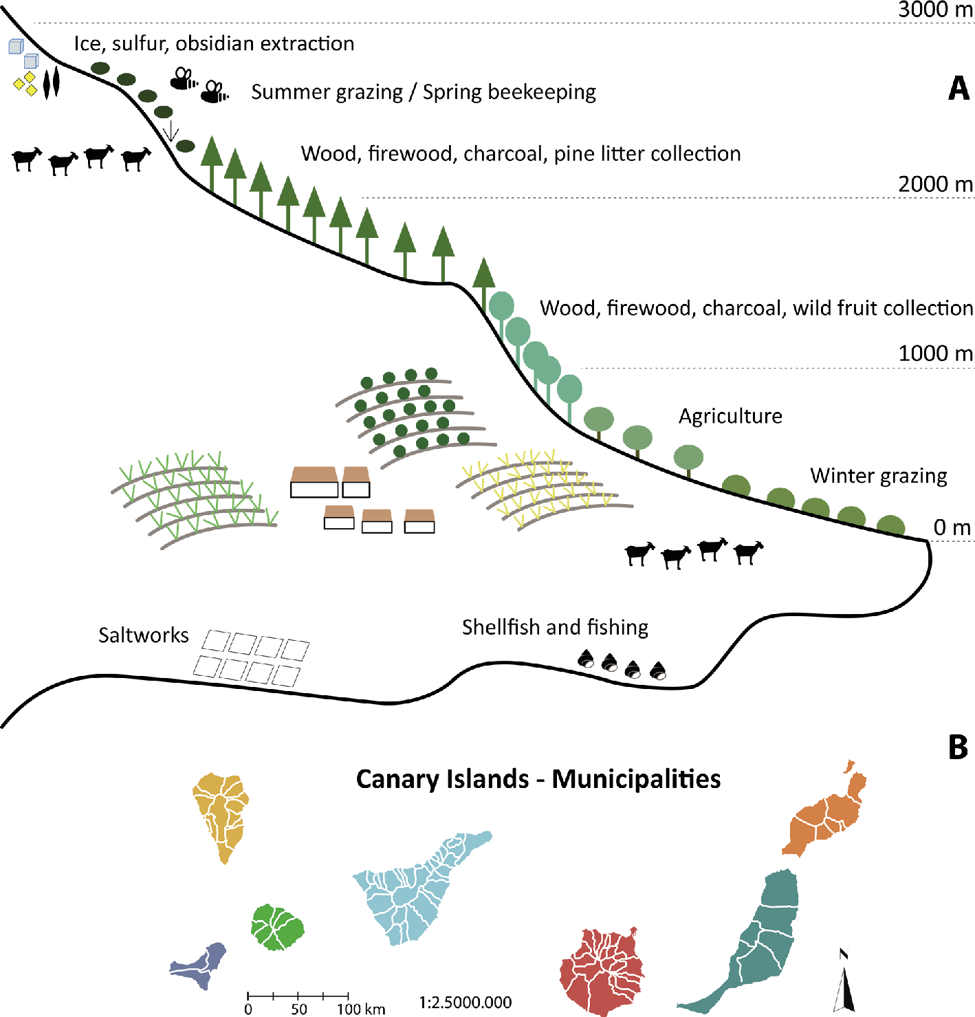
Figure 2: (A) Vertical exploitation of resources following the elevation gradient in Tenerife (Canary Islands; adapted from Aguilera et al. 1994), and (B) limits of the municipalities distributed from coast to summit in the Canary Islands. |
Since prehistoric times, humans have maximized the use of available resources at different elevations through the exploitation of coasts (saltworks, shellfishing), midlands (agriculture and forestry) and summits (green pastures, sulfur, ice collection; Aguilera et al. 1994), driving the altitudinal configuration of the present municipalities in Macaronesia (Fig. 2).
After the Castilian conquest of the Canaries (1402-1496 AD), the new society changed from a pastoral to an agricultural economic base, shifting the cultural impacts abruptly from species threats to deforestation, to provide firewood for sugar mills and land for sugarcane plantations, as well as timber for house and boat building. The archipelago also suffered severe droughts during the 17th and 18th centuries, leading to starvation and massive migrations among islands (García et al. 2003).
Madeira or “Island of Wood” owes its name to the primeval forests that used to cover it, which provided an important source of woods for Portugal. Since Madeira’s discovery in 1418, documents show that the exploitation of the forests allowed the building of larger ships for the Portuguese navy (contributing to the expansion of the conquests) and even for the growth in height of Lisbon’s buildings. The deforestation in Madeira was so fast that royal decrees from 1493 exist to limit it (Menezes de Sequeira et al. 2007).
The over-exploitation of forests, agriculture, fire and the introduction of alien species led to the extinction or extirpation of native species, such as rails (Rallus), the Porto Santo flora, and most probably unknown trees described in historical chronicles (Menezes de Sequeira et al. 2007).
On the Azores, the northernmost archipelago of Macaronesia, islands discovered by colonists that were suitable for growing European crops have since lost much of their original vegetation (e.g. Graciosa island), while the wettest, steepest parts of some islands have retained relatively intact vegetation (e.g. Flores island). Indeed, pollen records show that laurel and juniper forests were distributed at various elevations prior to human colonization (Connor et al. 2012). Historical reports attest to the density and diversity of this original vegetation, along with the presence of species that are now extinct on certain islands (e.g. Juniperus brevifolia and Taxus baccata). Human impacts were felt even before colonization began, with the release of livestock providing meat for future colonists (Schaefer 2003).
Although the Azorean vegetation was well adapted to recover from disturbances such as landslides and volcanic eruptions, human colonization caused irreversible changes, including the loss of forest trees, local extinctions and the creation of novel vegetation communities (Connor et al. 2012; Schaefer 2003). Timber felling, burning and various agro-pastoral monocultures have shaped the Azorean landscape since the time of colonization. Like many colonized islands, exotic plants today greatly outnumber native species on the Azores, and invasive species are a major threat to the island’s native biodiversity (Schaefer 2003).
Finally, Cape Verde is the southernmost and only tropical archipelago of Macaronesia. It is thought to have been uninhabited when the Portuguese colonized it around 1462 AD (Heckman 1985). The first settlers and expeditions described the landscape as having reduced forest cover with a mix of tropical and temperate species. In addition, historians pinpointed that the earlier settlers likely mismanaged the natural resources of the islands and that no attempt was made to create self-sufficient colonies (Heckman 1985).
The primary function of the islands of Cape Verde for the first hundred years was to serve as a base for the slave trade. In addition, many ships stopped to resupply food and water. During the 15th and 16th centuries, large plantations raised cotton, coffee, maize, and sugar cane. During the 17th century, some islands successfully established livestock.
Despite paleoecological and paleoclimate research still in their initial phase in Macaronesia, it has already provided evidence for climate change and human interactions. We are sure that, in the near future, ongoing research of the human impacts on these archipelagos will significantly increase our understanding of colonization processes and cultural evolution.
acknowledgements
We thank Claudia Ruiz for preparing Figure 2.
affiliations
1Island Ecology and Biogeography Group, Universidad de La Laguna, San Cristóbal de La Laguna, Spain
2Geography and Environment, University of Southampton, UK
3Department of Zoology, University of Oxford, UK
4Department of Geography and History, Universidad de La Laguna, San Cristóbal de La Laguna, Spain
5School of Geography, The University of Melbourne, Australia
6Madeira Botanical Group, University of Madeira, Funchal, Portugal
7Department of Geology, University of Lisbon, Portugal
contact
José María Fernández-Palacios: jmferpal ull.es
references
Aguilera F et al. (1994) Canarias. Economía, Ecología y Medio Ambiente. Francisco Lemus Editor, 361 pp
Atoche P (2009) Zephyrus 63: 105-134
Atoche P, Ramírez MA (2011) An Estudios Atlánticos 57: 139-169
Björck S et al. (2006) Quat Sci Rev 25: 9-32
Connor SE et al. (2012) J Biogeogr 39: 1007-1023
de Nascimento L et al. (2009) J Biogeogr 36: 499-514
de Nascimento L et al. (2016) Holocene 26: 113-125
García R et al. (2003) B Am Meteorol Soc 81: 1037-1039
Goodfriend GA et al. (1996) Palaeogeogr Palaeocl Palaeoecol 120: 195-234
Heckman J (1985) Environ Manage 9: 141-150
Machado MC (2007) Tabona 15: 71-90
Menezes de Sequeira et al. (2007) In: Silva J (Ed.) Árvores e Florestas de Portugal. Vol. 6 Açores e Madeira - A Floresta das Ilhas. Público, 165-196
Nogué S et al. (2013) J Ecol 101: 368-377
Rando JC (2003) El Indiferente 14: 4-15
Valentí Rull1, N. Cañellas-Boltà2, O. Margalef3, S. Pla-Rabes3, A. Sáez4 and S. Giralt1
Easter Island’s cultural shifts have been explained mostly by anthropogenic forcing and climate changes have been dismissed as relevant drivers of societal change. Recent findings demand a more complex scenario in which climatic, ecological and cultural factors interact.
Easter Island (Rapa Nui) is a small (164 km2) and remote Pacific island formed by the coalescence of three volcanic cones. The interior uplands are dominated by the Terevaka volcano (511 m elevation) to the north, and the rest of the island is characterized mostly by lowlands. Easter Island has been the home of several scientific enigmas including the chronology of its settlement by people, the origin of the first settlers, and the timing and causes of the disappearance of the ancient Rapanui civilization that built the megalithic statues known as moai.
 |
|
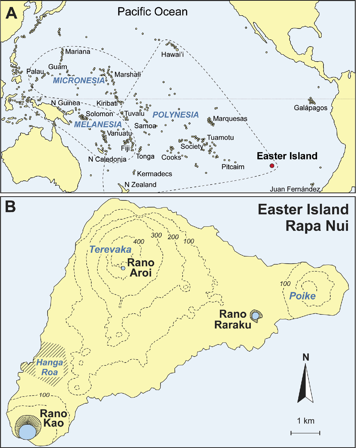
Figure 1: Location map. (A) The Pacific Ocean and its main archipelagos (Easter Island is highlighted by a red dot). (B) Sketch-map of Easter Island indicating the sites referred to in the text. |
The currently available evidence favors colonization from Eastern Polynesia (Fig. 1) between AD 800 and 1200 (Flenley and Bahn 2003; Hunt 2007; Wilmshurst et al. 2011). However, the breakdown of the ancient Rapanui culture is still debated. The more widely known theory is the occurrence of a cultural collapse following the anthropogenic deforestation of the island and the associated ecological catastrophe or ecocide (Diamond 2005). An opposing view is that deforestation was largely caused by massive tree-seed consumption by introduced Polynesian rats (Hunt 2007). According to this view, cultural collapse was not a consequence of deforestation but of slave trading and the introduction of unknown diseases after the European contact (AD 1722). Hypotheses on the potential influence of climatic changes have been traditionally underrated in favor of anthropogenic explanations (Flenley and Bahn 2003). In the last decade, however, important evidence for climatic shifts on the island and its regional context has grown, and proposals based solely on human pressure have been challenged.
Early proposals
The first proposals of a potential influence of climate on ecological and cultural shifts on Easter Island were based on theoretical assumptions, rather than on factual evidence. For example, McCall (1993), by analogy with other geographical areas, argued that droughts during the Little Ice Age (LIA; ca. 14th to 19th centuries) might have affected the island’s ecosystems and human practices leading to relevant cultural changes. However, evidence of such changes on the island was still lacking. Nunn (2007) proposed that Polynesian climates were relatively stable during the Medieval Climate Anomaly (MCA) but a phase of general instability and lower sea level started at AD 1300 and continued during the LIA, possibly caused by an intensification of the El Niño-Southern Oscillation (ENSO) variability. This climatic reversal would have led to widespread ecological and social crises in the region, and the cessation of transoceanic navigation. According to Nunn (2007), the cultural shift that represented the end of the ancient moai-building Rapanui society was a consequence of the LIA climatic deterioration but direct in situ evidence of climatic changes on the island remained to be demonstrated.
Azizi and Flenley (2008) studied sediments from Lake Raraku (Fig. 1) corresponding to the Last Glacial Maximum (LGM) and found palynological evidence of forest continuity, in spite of the presumed temperature and moisture declines. These authors concluded that if forests were resilient to climatic changes as intense as the LGM, further late glacial and Holocene environmental shifts of lower intensity could not have been responsible for the island’s deforestation. This reinforced the view that the recent historical deforestation should have been anthropogenic, rather than of climatic origin. The influence of the ENSO variability was dismissed on the basis of instrumental records of the second half of the 20th century and modeling results showing that such interannual periodical forcing was unable to cause significant variations in precipitation patterns during the last millennium (Genz and Hunt 2003; Junk and Claussen 2011).
Climate changes
 |
|
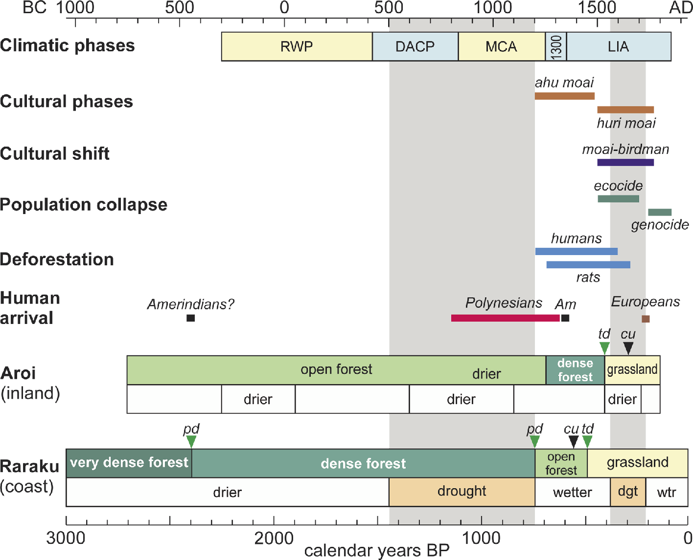
Figure 2: Summary of the climatic, ecological and cultural trends of Easter Island over the last three millennia (simplified from Rull et al. 2016). Drought phases are shaded. Horizontal bars represent the age range for the occurrence of the indicated cultural and environmental events, according to the available literature. Abbreviations: RWP = Roman Warm Period, DACP = Dark Ages Cold Period, MCA = Medieval Climate Anomaly, 1300 = “1300 event”, LIA = Little Ice Age, Am = Americans, cu = first evidence of local cultivation, dgt = drought, pd = partial deforestation, td = total deforestation, wtr = wetter. |
During the last two decades, paleoecological and paleoclimatic research on Easter Island has intensified and new sedimentary records have been obtained that provide new evidence for climatic changes during the last millennia. The first records suggesting the occurrence of arid climates during the Late Holocene came from Lake Raraku, in the coastal lowlands, and were used to tentatively relate aridity and ecological shifts, especially associated to forest dynamics (Mann et al. 2008; Sáez et al. 2009). Further work on the same lake yielded an almost continuous record for the last 2700 years that provided evidence for two drought phases, between ~AD 880 and 1170 and ~AD 1570 and 1720 (Cañellas-Boltà et al. 2013). The peats of the Rano Aroi swamp, in the interior uplands (Fig. 1), provided a continuous record of a similar time period showing three phases of landscape opening (i.e. forest retraction) associated to drier climates at 300 BC to AD 50, AD 600 to 1100, and AD 1520 to 1700 (Rull et al. 2015). The two later phases roughly coincided with the Lake Raraku droughts and occurred during the MCA and the LIA, respectively (Fig. 2).
Deforestation
The Raraku and Aroi records showed heterogeneous deforestation patterns across the island. In Raraku, deforestation began by 450 BC and was associated with the onset of charcoal and the pollen of Verbena litoralis, a weed of American origin (Cañellas-Boltà et al. 2013). This challenged previous theories of a unique colonization event from Polynesia by AD 800-1200. However, this is not a direct evidence of human presence and should be confirmed with further studies. In addition, archaeological evidence for such an early colonization (BC 450) is still lacking. The deforestation of this catchment was completed by AD 1530 (Fig. 2); therefore, forest clearing was a slow and gradual process elapsing two millennia. The situation was very different in the Aroi catchment, where forests remained virtually untouched until AD 1520 and were rapidly removed in roughly one century. This deforestation coincided with the appearance and sudden increase of charcoal particles suggesting anthropogenic burning (Rull et al. 2015). Another difference between the Raraku and Aroi sites was that, prior to deforestation, the first was occupied by dense forests whereas the second was covered by open forests (Fig. 2). This has been explained in terms of altitudinal differences in the vegetation cover due to climatic constraints (Flenley and Bahn 2003), a hypothesis that has not been confirmed yet. In the Kao basin, the lack of a reliable chronology (Butler and Flenley 2010; Horrocks et al. 2013) complicates the interpretation, but the record showed the occurrence of two deforestation events, between AD 50 and 100, and AD 1350 and 1800 (Butler and Flenley 2010). Spatio-temporal differences in deforestation patterns agree with the apparent heterogeneity in land-use practices documented by archaeological evidence (Stevenson et al. 2015). The combined evidence obtained so far suggests a conspicuous pattern of coastal abandonment toward inland settlements, a common feature in many eastern Pacific archipelagos during the same times (Nunn 2007).
A new scenario
The concurrence of conspicuous climatic, ecological and cultural changes during the last millennia suggests that the recent history of Easter Island may be more complex than previously thought and that natural and anthropogenic drivers of change, as well as their potential synergies, might have been influential in determining cultural shifts (Rull et al. 2016). Rather than simplistic scenarios of single, simultaneous and island-wide cause-effect relationships, a holistic perspective that considers all the potential forcing factors should be pursued to explain Easter Island’s landscape and cultural changes. Further research should be addressed under a new perspective including paleoecological, archaeological, anthropological and historical evidence. The incorporation of direct sedimentary evidence of human presence, such as fecal lipids or DNA, is strongly recommended (Rull et al. 2016).
affiliations
1Institute of Earth Sciences Jaume Almera (ICTJA-CSIC), Barcelona, Spain
2Department of Prehistory, Ancient History and Archaeology, Universitat de Barcelona, Spain
3Ecological Research Center and Forestry Applications (CREAF), Cerdanyola del Vallès, Spain
4Department of Earth and Ocean Dynamics, Universitat de Barcelona, Spain
contact
Valentí Rull: vrullictja.csic.es
references
Azizi G, Flenley JR (2008) Quat Int 184: 166-176
Butler KR, Flenley JR (2010) Rapa Nui J 24: 5-10
Diamond JM (2005) Collapse: How Societies Choose to Fail or Succeed. Penguin, 608 pp
Cañellas-Boltà N et al. (2013) Quat Sci Rev 72: 36-48
Flenley JR, Bahn PG (2003) The Enigmas of Easter Island. Oxford University Press, 256 pp
Horrocks M et al. (2013) J Paleolimnol 50: 417-432
Genz J, Hunt TL (2003) Rapa Nui J 17: 7-17
Hunt TL (2007) J Archaeol Sci 34: 485-502
Junk C, Claussen M (2011) Clim Past 7: 579-586
Mann D et al. (2008) Quat Res 69: 16-28
McCall G (1993) Rapa Nui J 7: 65-70
Rull V et al. (2015) Quat Sci Rev 126: 219-226
Rull V et al. (2016) Front Ecol Evol 4: 29, doi 10.3389/fevo.2016.00029
Sáez A et al. (2009) Quat Sci Rev 28: 2743-2759
Andrés Holz1, C. Méndez2, L. Borrero3, A. Prieto4, F. Torrejón5 and A. Maldonado6
Multidisciplinary research in fire dynamics in the Patagonian-Andean region is incipient. In this review, we synthesize archaeological, anthropological, paleo-, dendro- and neoecological projects on past climate-human-fire-vegetation dynamics to establish ecological benchmarks to burning over time.
 |
|
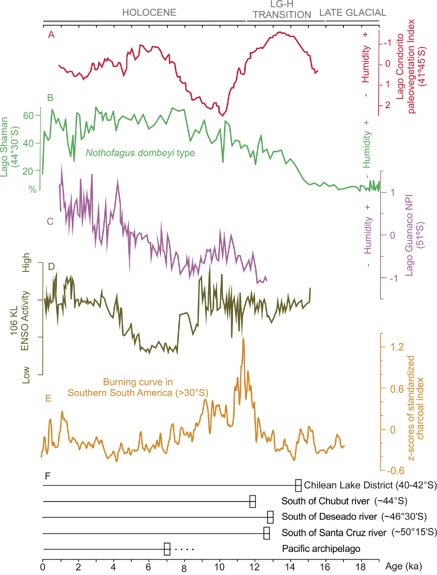
Figure 1: Location of regional earliest archaeological (calibrated ages BP in parenthesis) and paleoecological sites and main modern vegetation types cited in the text. The western and eastern Patagonian-Andean regions encompass the Magellanic and evergreen forests and deciduous forest and steppe, respectively. |
Fire, one of the most ubiquitous disturbances on earth, is a key driver of ecosystem dynamics globally. Fire controls major boundary dynamics and even the distribution of certain biomes. Hominins have altered the geography and regimes of fires from ca. 1.5 million years ago (Parker et al. 2016), and, in turn, fire became a key tool for evolutionary history, through impacts on landscape and resources, and constraints on knowledge, inter-group competition and geography. This work reviews the potential impact of human-set fires, favored by climate conditions, on forests and grasslands since their first appearance in two Patagonian-Andean regions: the wetter western region, from the Pacific coast to the Andean peaks; and the drier eastern region, from the Andean peaks to the Atlantic coast (Fig. 1).
The role and sources of fire ignition in southern South America (SSA; south of ca. 38°S) have been long-debated. Some have ignored top-down climate factors and highlighted large-scale impacts of human-set fires (i.e. Heusser 1994), whereas others have preferred a perspective of fine-scale human impact favored by conducive climate-fire conditions (Markgraf and Anderson 1994; Holz and Veblen 2011a; Méndez et al. 2016). In Patagonia, fire was among the key tools of human groups for activities such as cooking, heating and hunting, as suggested by ethnographic sources. The archaeological records suggest that human occupation (and burning activity) was neither continuous nor homogenous over time and space (Fig. 1; 2e,f). The interpretation of the role of humans in setting fires in Patagonia is also a point of contention – some claim that first human appearances coincide with the onset of regional fire activity, others argue peaks in fire activity are only significant during periods when higher population densities were present throughout the landscape. For instance, at the northern margin of Patagonia, evidence of anthropogenic fire is documented from ca. 18.5-14.6 ka cal BP, the age of the earliest evidences of human settlement (i.e. Monte Verde at ca. 41°S; Dillehay et al. 2015), and reached southernmost Patagonia (ca. 52-55°S) at ca. 12.6 ka cal BP (Fig. 1).
 |
|
Figure 2: Changes in climate, fire and human occupation in southern South America over time. Pollen-based humidity paleo-indices for Northern (A), Central (B), and Southern (C) Patagonia. (D) Lithic flux rate (% of maximum; Marine core ENSO reconstruction at 12ºS). (E) Burning curve in SSA (>30ºS, smoothed with a 200-year window. (F) First-arrival dates based on earliest regional archaeological records. |
From a top-down perspective, fire activity in Patagonia has been controlled by natural ignition, biomass accumulation and climate variability at multiple time scales: from millennial (e.g. summer insolation and westerly winds strength and position; Whitlock et al. 2007), centennial (i.e. location of subtropical pacific anticyclone, and westerly winds strength and position; Holz et al. 2012), to decadal and interannual scales (e.g. El Niño Southern Oscillation, ENSO; The Southern Annular Mode, SAM; Holz and Veblen 2011b). Under current climate conditions, fires occur during the Austral summer, and natural ignitions are relatively rare on the western Andean slope but common on the drier, eastern side of the Andes (Kitzberger et al. 2016).
Climate, fire, vegetation, and human occupation
In Patagonia, vegetation developed asynchronously across latitude and longitude, with broadly earliest establishment in Northern Patagonia, east of the Andes, and latest development in Southern Patagonia, west of the Andes. Wet/cool conditions were observed since the last glacial maximum and during the transition to the Holocene that favored establishment of initial forest taxa at ca. 16.5-13.5 ka BP in Northern Patagonia (ca. 37-44°S; Iglesias et al. 2016). In the early Holocene (ca. 11.5-8 ka BP), initial forest taxa established south of ca. 44°S (de Porras et al. 2012) under high El Niño (positive ENSO) activity, coinciding with drier conditions in Northern Patagonia, and wetter and warmer conditions in Central and Southern Patagonia, respectively (Fig. 2a-d). These conditions favored the highest peak in fire activity on record in Patagonia (Fig. 2e). During the Mid Holocene (ca. 8-4 ka BP), wet conditions in North and Central Patagonia coincided with a dry-to-humid transition in Southern Patagonia and low ENSO activity. Overall high climate variability was observed in the late Holocene (ca. 4 ka BP to present), with intermediate fire activity that co-occurred with mid-to-high ENSO activity, drying conditions in Northern and Central Patagonia, and very humid conditions in Southern Patagonia – presumably due to a southward shift of the westerlies (rather than changes in human ignition or westerlies strength; Fig. 2a-e). Over the last several hundred years, fires occurred mainly during fire-prone phases of ENSO and SAM (Holz and Veblen 2011a).
In western Patagonia, fire records date back to ca. 11 ka BP (e.g. Holz et al. 2012), which precede human arrival (ca. Mid Holocene, Fig. 2f). In this region, the archaeological record is richest over the last two millennia (Reyes et al. 2015). At the time of first European contact (ca. late 1500s), indigenous groups practiced localized slash and burn agriculture (ca. 40-44°S). Further south in the channels, with cooler and wetter conditions, small canoeist groups lived off seal hunting, fishing and used pyrite for starting bonfires (Fig. 1). These groups were known to transport active bonfires in their canoes. Pyrite was also commonly used to burn small coastal temperate rainforest patches that were subsequently harvested for fuel. Starting in the mid-1750s, European-settlers burned vast extensions of native forests to facilitate access to coastal rainforest trees of valuable timber (Holz and Veblen 2011a). On the western Andean slopes, most tree species can neither resist nor recover following large, high severity events, which eliminate seed source. Some tree species, however (e.g. Pilgerodendron) can recover from sporadic, low-to-moderate fire severity events (Kitzberger et al. 2016).
Along the eastern Andean foothills, fires have been recorded as far back as ca. 17 ka BP (Iglesias et al. 2016), and precede human contact (Fig. 1, 2e,f). Tehuelche people set fires for smoke signaling and hunting – activities that vastly increased in the 18th century with the introduction of horses. Tehuelche people had higher demographic concentrations than coastal groups and were known for their series of bonfires burning in front of and inside their toldos (hide huts). Some of the dominant forest taxa in this region possess traits that allow them to resist fire (e.g. thick bark and self-pruned stem in Araucaria) and quickly re-establish following fires (e.g. sprouting capabilities in Nothofagus antarctica; Kitzberger et al. 2016).
Regional trends and multidisciplinary research in Patagonia
At the largest scale, fire in Patagonia appears to have been shaped by both climate conditions and human ignitions. Overall trends in fire activity correspond well with millennial-scale variability in moisture availability (Fig. 2). The highest fire peak on record, however, took place not long after first human contact across Patagonia, and hence cannot be explained by climate conditions alone. These big-picture results suggest that climate conditions control fire activity at large scales, but human ignitions were responsible for pulses in fires (as long as climate conditions were suitable for burning).
At this large scale, it is difficult to assess the relationship between demographic density and the impact of human-set fires. Instead, site-specific studies with multidisciplinary approaches seem more useful; e.g. archaeo-paleoecological paired work in the deciduous forest and steppe ecotone in Central Patagonia (44°S) found that human presence strongly correlate with fires throughout the Holocene, especially during periods of high fuel availability (i.e. wet periods; Fig. 1; Méndez et al. 2016). In the evergreen forest and peatland ecotone of western Patagonia (47°S), paired paleo-dendro-neoecological data with historical analyses indicate that indigenous fine-scale burning was common before European-settlers’ arrival (Fig. 1; Holz and Veblen 2011a). Studies also indicate that 20th-century burning reached peaks up to four times higher than at any time during the Holocene (Holz et al. 2012) and has transformed the plant community into an alternative, more flammable vegetation state (Kitzberger et al. 2016). Studies conducted in similar biophysical settings in New Zealand suggest that relatively small groups of Maori people were able to burn and transform very large extensions of temperate forests ca. 0.8 ka BP because of vegetation flammability-fire feedbacks (Perry et al. 2012). We expect that ongoing multidisciplinary work will shed new light on the role that humans had on shaping past environments in Patagonia.
acknowledgements
This research was supported by the US NSF (0966472), FONDECYT (1130128, 1130151, 1120765) and FONDAP CRHIAM (15130015).
affiliations
1Department of Geography, Portland State University, Portland, USA
2Department of Anthropology, University of Chile, Santiago, Chile
3Instituto Multidisciplinario de Historia y Ciencias Humanas, Buenos Aires, Argentina
4Campus Natales, University of Magallanes, Punta Arenas, Chile
5Aquatic Systems Research Unit, University of Concepción, Chile
6Centro de Estudios Avanzados en Zonas Áridas, University of La Serena, Chile
contact
Andrés Holz: andres.holzpdx.edu
references
de Porras ME et al. (2012) Quat Sci Rev 50: 71-85
Diaz MF et al. (2007) Forest Ecol Manag 244: 32-40
Dillehay TD et al. (2015) PLoS ONE 10, doi: 10.1371/journal.pone.0141923
Heusser CJ (1994) Rev Chil Hist Nat 67: 435-443
Holz A et al. (2012) Clim Past 8: 451-466
Holz A, Veblen TT (2011a) Palaeogeogr Palaeoclimatol Palaeoecol 311: 82-92
Holz A, Veblen TT (2011b) Geophys Res Lett 38, doi:10.1029/2011GL047674
Iglesias V et al. (2016) Palaeogeogr Palaeoclimatol Palaeoecol 457: 195-208
Kitzberger T et al. (2016) New Zeal J Bot 54: 247-272
Markgraf V, Anderson L (1994) Rev IG Sao Paulo 15: 33-47
Méndez C et al. (2016) Front Ecol Evol 4: doi: 10.3389/fevo.2016.00100
Parker CH et al. (2016) Evol Anthropol 25: 54-63
Perry GLW et al. (2012) Glob Change Biol 18: 1609-1621
Hugues Goosse1, M. Evans2 and S. Khatiwala3
 |
|
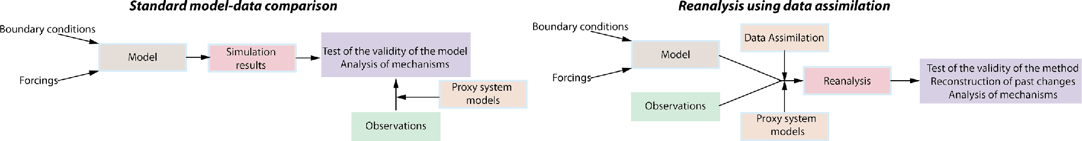
Figure 1: Schematic representation of a classical model-data comparison and of a reanalysis, illustrating in particular the role of proxy system models. |
The analysis of observations and numerical simulations are two key pillars of many scientific disciplines. Traditionally, a study is initially focused on one of these two aspects and the other one appears in a second stage, to test a hypothesis or validate a conclusion (Fig. 1). Data assimilation uses observations and simulations to produce estimates based on both sources of information, given uncertainties in each. If key assumptions within the approach are met, this approach allows estimation for regions and times which lack observations, leads to mechanistic analyses and re-evaluation of uncertainty estimates, and provides the rationale for new observational and modeling experiments.
Perhaps, particularly in paleoscience, combining the information deduced from simulations with that from observations may not be straightforward and a wide range of issues must be addressed before that is possible. For instance, the variable measured in environmental archives collected in the field (such as tree-ring width or pollen assemblage) may not be directly simulated by the model, it may map as a response to more than one environmental variation, and there is chronological uncertainty. Model results and observations thus have to be processed and interpreted appropriately before a quantitative evaluation of the agreements and inconsistencies between the two may be made. The spatial scales represented by the records and model results are generally also different and difficult to determine accurately. Additionally, both observational error and model biases need to be quantified to make a meaningful comparison, and new approaches to validation of the results and interpretations must be developed.
The goal of the new PAGES working group on Paleoclimate Reanalyses, Data Assimilation and Proxy System modeling (DAPS; pastglobalchanges.org/daps) is to address these challenges. Specifically, DAPS is designed to stimulate the development of methods for the joint and quantitative use of observations and models in paleoscience, by promoting integrative research and mechanistic understanding of process and history by combining, as objectively as possible, all available sources of paleoenvironmental information.
Reanalyses are probably the most complete illustration of the approach. Using data assimilation techniques, they combine observations with a description of the dynamics of a system, as represented in a model, to reconstruct the state of this system, explicitly taking into account all the uncertainties in each. Observations and model are thus merged from the beginning of the process (Fig. 1). The quality of the product is linked to the quality of both sources of information but, even more crucially, their integration. This implies a deep understanding of not only data assimilation techniques and dynamics, but also the characteristics of the paleoclimate records and their uncertainties. This requires strong interaction between the different communities involved.
A critical step in the reanalysis is an objective model-data comparison. This implies the development and inclusion of “proxy system” models (e.g. Evans et al. 2013) for the paleoclimatic observations, so the measured variable can be directly assimilated into numerical simulations. Ideally, those proxy system models are based on a mechanistic understanding of the way the recorded signal arises from the external environmental conditions as simulated by the numerical model, then imprinted into an archive, and observed. Proxy system models may also be applied in standard simulations when model outputs are compared to observations.
Successful applications of proxy system models and data assimilation have been previously demonstrated (e.g. Dee et al. 2016). DAPS will review these and identify areas in which improvements can be achieved through synergies and coordination. Another important goal is to establish a code repository facilitating joint activities, and to encourage new users to develop applications and collaborations, particularly between groups that have traditionally not yet extensively interacted. The plan is to further these goals through workshops and training activities organized via DAPS, targeting both early-career and experienced scientists and those who may not be familiar with data assimilation techniques.
Join this initiative! Subscribe to the DAPS mailing list (http://listserv.unibe.ch/mailman/listinfo/daps.pages) to be informed about plans for workshops and training activities. Do not hesitate to contact the members of the steering committee with questions and suggestions.
affiliations
1ELIC/TECLIM, Université catholique de Louvain, Belgium
2Department of Geology, University of Maryland, USA
3Department of Earth Sciences, University of Oxford, UK
contact
Hugues Goosse: hugues.goosseuclouvain.be
references
Alistair W.R. Seddon1, L.E. Cole2, J. Morris3, M.-S. Fletcher4 and K.J. Willis5
“Resilience” is a key attribute needed to ensure the persistence of Earth’s ecosystems in the face of increasing anthropogenic stressors and climate change. Yet definitions of resilience, and the methods used to measure it, can differ markedly between studies (Hodgson et al. 2015). These disagreements make it difficult to compare and identify systems with more or less resilience and to plan future mitigation strategies.
 |
|
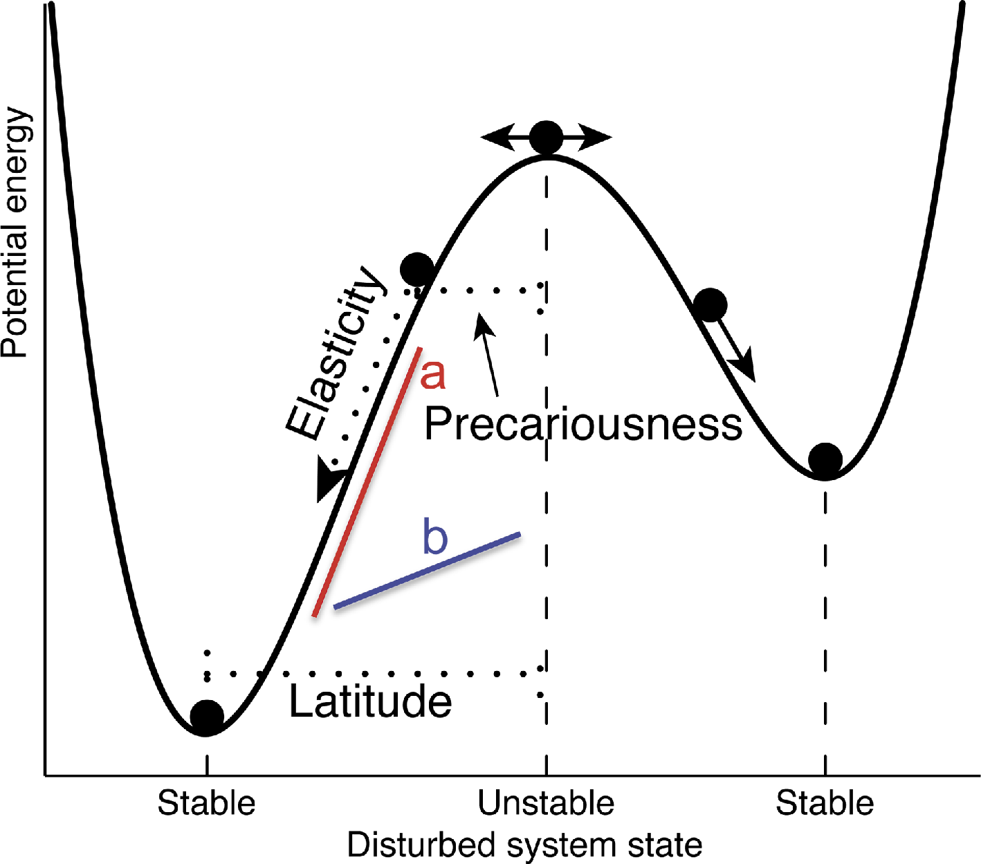
Figure 1: Components of resilience (adapted from Hodgson et al. 2015), showing a classical resilience landscape where components of resilience can be derived. See Box 1 for definitions. |
One useful approach is to integrate the different concepts of resilience within one unifying framework, by identifying the different “components” of resilience that lead to a system maintaining ecological functioning in the face of disturbance (Fig. 1). This is the first step for understanding what factors cause variations in resilience between different ecosystems. The next challenge is to develop tools to measure these components across biomes.
Recent attempts have used satellite data to map some components of resilience at global scales (e.g. Seddon et al. 2016). These “snapshots” are based on measuring short-term ecological responses, but whether the patterns reflect fundamental properties of the systems, or are the result of historical disturbance legacies, remains unknown. Sediments provide a long-term record of disturbances and ecological responses for investigating resilience (e.g. Cole et al. 2014), but the appropriate metrics for comparing components of resilience from sediments across different ecosystem types are yet to be developed.
EcoRe3 is a new PAGES working group which aims to devise a set of standardized approaches for comparing components of resilience from the paleo-record. We focus on measuring resistance (the amount of change following a disturbance), recovery (the speed to return to equilibrium following a disturbance) and how these components contribute to the resilience (the ability to tolerate disturbance and remain in the same state) in ecological systems using long-term data.
Scientific objectives
|
Elasticity: Speed of recovery to equilibrium following a disturbance. Determines the recovery rate. Precariousness: Distance to an ecological threshold or tipping point. Latitude: Width of the basin (or ecological resilience, e.g. Holling 1973). Resistance: Amount of change following a disturbance (in Fig. 1, basin with slope “a” has higher resistance than slope “b”; e.g. de Keersmaeker et al. 2015). Sensitivity: Relative variance of system compared to driver (e.g. Seddon et al. 2016). |
|
Box 1: Components of resilience - definitions |
EcoRe3 is based around four key scientific objectives:
Theory: We will develop methods, grounded in ecological theory, to measure and compare resistance, recovery and resilience using long-term ecological datasets. These will be explored at the first EcoRe3 workshop in March 2017 (pastglobalchanges.org/calendar/127-pages/1652).
Application: Using a series of high-resolution paleoecological records to test the use of these approaches will enable us to compare components of resilience across biomes, and investigate which biotic and abiotic controls are responsible for the observed patterns.
Training: Open-Source code will be developed for all analyses to ensure reproducibility of the methods. A workshop for early-career scientists, towards the end of the group's third year, is planned.
Integration: A major goal is to find ways to collaborate with scientists interested in resilience across different disciplines. In addition to working together with other PAGES working groups, we plan to investigate how to integrate the tools developed on paleo-datasets into those that can be used for the management of contemporary ecosystems.
For further information about EcoRe3 activities, please subscribe to the mailing list. pastglobalchanges.org/ecore3
affiliations
1Department of Biology, University of Bergen, Norway
2Department of Zoology, University of Oxford, UK
3Department of Geography, University of Utah, Salt Lake City, USA
4School of Geography, University of Melbourne, Australia
5Oxford University and Royal Botanic Gardens, Oxford, UK
contact
Alistair Seddon: alistair.seddonuib.no
references
Cole LES et al. (2014) Nature Comm 5, doi:10.1038/ncomms4906
Hodgson D et al. (2015) Trends Ecol Evol 30: 503-506
Bruno Wilhelm1 and Juan Antonio Ballesteros-Cánovas2
1st Floods Working Group meeting, Grenoble, France, 27-30 June 2016
 |
|
Figure 1: September 2014 flood event in Kashmir valley (India) leading to the complete submersion of houses of the largest city, Srinagar, during several days (National Disaster Response Force - NDRF). |
PAGES’ Floods Working Group (FWG) contributes to global knowledge of the variability of flood frequency and magnitude. The cross-disciplinary analysis of hydrological extreme events involves different temporal (from seasons to millennia) and spatial scales (regional to continental).
FWG’s first workshop, involving 46 researchers from 16 countries (a third being early-career scientists), was the starting point to establish a community devoted to past and present floods and create links between paleoscientists, historians, statisticians, hydrologists and climatologists. The principal objectives were to share disciplinary experiences, promote interdisciplinary collaborations and design future projects and products for the group. Introductory keynote presentations were given before the sessions by N. Macdonald, S. St George, R. Denniston, M. Macklin, B. Valero Garcès, L. Schulte and M. Mudelsee.
The first session reviewed the different archives (i.e. sedimentary, speleothem, tree-ring and historical) and their suitability to document past flood occurrences and magnitude, with a particular focus on their respective advantages and limitations. This unprecedented systematic overview of all types of flood archives motivated participants and generated cross-disciplinary debates. The benefit of gathering flood data provided by different archives and methods was considered as great because of the wealth of information provided in term of data diversity and quantity for further analysis on flood variability.
The second session highlighted the potential for multi-archive flood approaches to get more precise and complete regional flood knowledge, including calibration of flood records with instrumental data. Participants pointed out opportunities and challenges to handle flood archives with different time resolutions. This should be the target of an interdisciplinary group project, with researchers from different fields collaborating towards a common understanding of past flood activity and exploring the possibility to integrate data of a different type within a unique dataset.
The last session was dedicated to statistical and modeling tools that could be applied to flood reconstructions to analyze flood patterns and identify responsible climate forcing. Particular emphasis was placed on the statistical comparison of archive data with instrumental records for flood hazard assessment. In the discussions following this session, the group identified the need to involve more climate modelers, hydrologists and risk managers to improve the understanding of the physical processes controlling the occurrence and magnitude of floods. These scientific collaborations and synergies could help to contribute to the present debate about floods-climate-human linkages and interactions.
Time was also dedicated to sub-group and plenary discussions on three specific topics: (i) the creation of a metadatabase of past flood events, (ii) the need to communicate the archive-based flood data to other communities, and (iii) collaborative efforts within the FWG. Based on a consensus, FWG’s next steps will be the creation of this metadatabase, gathering published data, followed by its analysis in a review paper. The metadata collection will be done by groups, each focusing on a specific type of archive. First, each group will identify the archive type-specific selection criteria for metadata collection and a set of common criteria will then be defined. Once this first database version is finalized, a format for the inclusion of the actual data will be defined and the data collection planned. The format for the database will build upon the work of other PAGES working groups (e.g. McKay and Emile-Geay 2016). Deadlines for these three steps were established in order to deliver the first metadatabase version at the PAGES OSM in Zaragoza (9-13 May 2017), where the next FWG meeting and the FWG-sponsored session “Multidisciplinary reconstruction of paleofloods” will take place.
Post-workshop materials (report, keynotes, talks and posters) are available here: pastglobalchanges.org/calendar/26553
acknowledgements
The workshop has been generously supported by PAGES, Labex OSUG@2020 (Investissements d’avenir – ANR10 LABX56), European Geosciences Union, Grenoble-INP and Université Grenoble Alpes.
affiliations
1LTHE, University Grenoble Alpes (CNRS, IRD), Grenoble, France
2Environmental Science, University of Geneva, Switzerland
contact
Bruno Wilhelm: bruno.wilhelmujf-grenoble.fr (bruno[dot]wilhelm[at]ujf-grenoble[dot]fr)
reference
Erin L. McClymont1, A.M. Haywood2, P. Dekens3, A. Rosell-Melé4 and L. Dupont5
Utrecht, The Netherlands, 2 September 2016
Following the International Conference on Paleoceanography in Utrecht, 40 members of the PlioVAR working group met to receive and discuss progress reports on synthesis work of existing and emerging multi-proxy marine data during the late Pliocene. Participants working with marine proxies and with varied regional interests were present, as well as those with previous experience in large paleoclimate syntheses. Six presentations were given, with the first outlining the aims and objectives of PlioVAR. The other five reported on the developing syntheses from the North Atlantic, South Atlantic, Pacific, Indian and Southern Oceans. An open discussion then considered the implications of the work so far, alongside future strategies to support continued synthesis. The questions and priorities identified during the meeting include:
1. Regional differences emerging in glacial-interglacial variability
 |
|
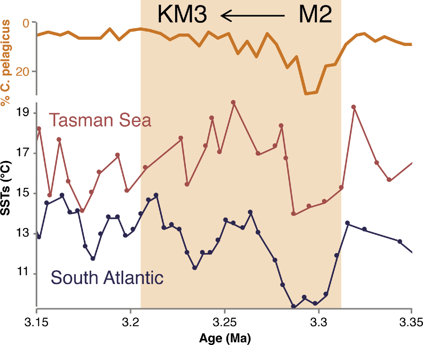
Figure 1: An example of data synthesis and comparison for the M2-KM3 transition from three southern hemisphere records: abundance of coccoliths from Coccolithus pelagicus at ODP Site 1172 (east of Tasmania; Ballegeer et al. 2012), and reconstructed sea-surface temperatures (SSTs) from DSDP Site 593 (Tasman Sea; McClymont et al. 2016) and ODP Site 1090 (Southern Atlantic; Martinez-Garcia et al. 2010). |
A target of PlioVAR is to assess the magnitude and rate of climate changes associated with the “M2-KM3” event, marked by ice-sheet expansion and then retreat around 3.3-3.2 Ma BP (Fig. 1). This climate transition was identified in many of the existing records, but its amplitude varied depending on local circulation (e.g. upwelling, proximity to fronts), water mass and the proxy used. The importance of setting the late Pliocene variability in the context of Pliocene-Pleistocene climate evolution was noted, and the potential to examine shorter timescale variability was outlined. Variations in dust supply and glacial inputs to marine sediments were also noted as potentially valuable indicators of atmospheric circulation, environmental change onshore and ice-sheet behavior.
2. Reconciling environmental signals from multi-proxy analyses
A key aim of PlioVAR is to draw together multi-proxy perspectives on climate and environmental variability. Discussion about the signals recorded by different temperature proxy records emphasized the importance of detailing proxy measurements and interpretations in both the original publications and in the PlioVAR synthesis. These issues are not unique to PlioVAR but the working group is mindful of the implications, especially for planned data-model intercomparison.
3. New insights expected from recent and planned ocean drilling
Several recent IODP expeditions have secured new archives which have great potential to contribute to the PlioVAR initiative, in areas where data is currently limited or absent (e.g. Exp 353 Indian Monsoon, Exp 354 Bengal Fan, Exp 355 Arabian Sea Monsoon, Exp 356 Indonesian Throughflow, Exp 361 Southern African Climates). Several members of the science parties for these expeditions were present, and future plans and preliminary data were noted.
4. Management and integration of published and emerging data
Several presentations outlined the challenges of identifying and downloading existing data for incorporation into the synthesis, particularly due to missing information about stratigraphy, proxy calibrations and interpretations, as well as data not being available post-publication. Recommendations for data formatting and upload were discussed, with a need for metadata (e.g. which calibration was applied, IODP sample identifiers plus depth scales, original not just calibrated data provided). Ongoing efforts to create a protocol for assessing the quality of the age control were noted. Several possible means of creating an interface to view and download available data were presented, and their potential will be explored further.
Several conference sessions with a PlioVAR focus are scheduled, for example at the AGU Fall Meeting (2016) and PAGES Open Science Meeting (2017). Anyone interested in contributing to PlioVAR is encouraged to participate. The next PlioVAR meeting (19-21 April 2017, in Durham, UK; pastglobalchanges.org/calendar/127-pages/1658) will take place shortly before the PAGES OSM to focus on advancing the marine synthesis efforts outlined here. More information will be transmitted through the PAGES website and via the working group mailing list (www.pastglobalchanges.org/ini/wg/pliovar/).
We thank PAGES for the funding support which made this meeting possible.
affiliations
1School of Geography, Durham University, UK
2School of Earth & Environment, University of Leeds, UK
3Department of Geosciences, San Francisco State University, USA
4ICREA and Universitat Autònoma de Barcelona, Spain
5MARUM - Center for Marine Environmental Sciences, University of Bremen, Germany
contact
Erin McClymont: erin.mcclymontdurham.ac.uk
references
Ballegeer A-M et al. (2012) Palaeogeog Palaeoclimatol Palaeoecol 313-314: 215-224
Matthew Toohey1, F. Ludlow2, A. LeGrande3, K.J. Anchukaitis4 and M. Sigl5
VICS workshop, Palisades, USA, 6-8 June 2016
The inaugural workshop of the PAGES Volcanic Impacts on Climate and Society (VICS) working group convened approximately 50 established and early-career researchers from across Europe, North America, South America and Asia. Attendees, representing a wide range of research fields, presented on topics grouped into three broad themes: reconstructing volcanic activity and climate forcing through time, climatic responses to volcanic eruptions, and societal resilience and vulnerability to volcanically induced climate change. Discussion sessions focusing on key cross-cutting scientific questions were held to stimulate brainstorming of potential products for the working group.
The importance of well-dated and accurate reconstructions of past volcanic activity was repeatedly acknowledged throughout the workshop. Ice cores provide perhaps the most complete record of global volcanism, with recently compiled and re-dated sulfate records allowing an estimation of the timing and magnitude of volcanic forcing back to 500 BC (Sigl et al. 2015), an advance that several attendees employed to refine our understanding of volcanic climatic and societal impacts. Developments were also showcased in the analysis of tephra particles in ice cores that allow volcanic sulfur signals to be traced to their source volcano, providing a link to the vast geological databases of volcanic eruptions. Attendees examined the challenges of translating proxies of past volcanism into knowledge of the associated radiative forcing, and highlighted the knowledge gained from the observation and modeling of recent, well-observed eruptions. Ongoing improvements in our ability to measure the isotopic signature of volcanic sulfur were also examined for their potential to reduce uncertainties in the radiative forcing inferred from the ice-core sulfate record.
Improvements in the spatial and temporal coverage and resolution of climate proxy records are allowing researchers to assess the impact of past volcanism on climate with increasing confidence. Speakers presented volcanic signatures in tree rings, speleothems, corals, glaciers and other proxies which reflect both the general global cooling that results from volcanic stratospheric aerosols, but also changes in atmospheric circulation and precipitation, including significant changes in monsoon-dependent agricultural regions now home to over 70% of the Earth’s population. Recent work on the 1815 eruption of Tambora suggests that the main contributor to the cold and wet conditions in Switzerland was changes in atmospheric circulation, not the decrease in solar radiation from aerosol backscattering (Brönnimann and Krämer 2016). There are hints that expected circulation responses to volcanic forcing, such as the “winter warming” pattern over the Northern Hemisphere continents, can in fact be reproduced by climate models, but remaining notable discrepancies between simulated and reconstructed post-volcanic anomalies were highlighted. Speakers presented ongoing efforts to address such discrepancies through improved implementation of volcanic eruptions across climate models, and through collaborative standardized model experiments (Zanchettin et al. 2016).
 |
|
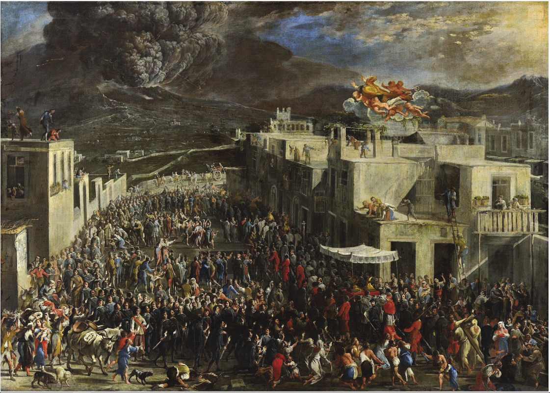
Figure 1: Seventeenth century painting (oil on canvas) of Vesuvius erupting in AD 1631, by Domenico Gargiulo, depicting a religious procession (foreground) to secure divine deliverance from the eruption. Saint Januarius (San Gennaro) is also depicted flying above the procession (top foreground) in the direction of the mountain (Cocco 2013). Image from Wikimedia Commons in the public domain. |
Historical sources are increasingly recognized as providing valid paleo-climatic data at high spatial and temporal resolutions to complement instrumental records, tree-rings and other proxies (e.g. Gao et al. 2016). Of societal responses, historical sources are revealing not only of the immediate landscape and social impacts of eruptions (Fig. 1), but also how past societies coped with abrupt volcanically induced climatic shocks. Workshop participants thus presented societal-impact case studies from locations ranging from the far north, where agricultural societies were very susceptible to changes in summer temperature, to the tropics, where variations in the monsoons or river runoff had major agricultural impacts. These studies show how historians have rapidly incorporated recent advances in volcanic-forcing histories, and signaled that much more can be learned. Societies were not vulnerable in the same way in different seasons, for example, and the seasonality and scale of volcanic climatic impacts may differ with the location and timing of eruptions. Further advances can thus be achieved by closer dialogue between climate scientists, historians and other scholars of the human past.
acknowledgements
We thank PAGES, the Climate Center of the Lamont-Doherty Earth Observatory and NASA Goddard Institute for Space Studies, and the Yale Climate History Initiative for financial support.
affiliations
1GEOMAR Helmholtz Centre for Ocean Research Kiel, Germany
2Department of History, Trinity College Dublin, Ireland
3NASA Goddard Institute for Space Studies, New York, USA
4School of Geography and Development, and Laboratory of Tree-Ring Research, University of Arizona, Tucson, USA
5Paul Scherrer Institute, Villigen, Switzerland
contact
Matthew Toohey: mtooheygeomar.de
references
Brönnimann S, Krämer D (2016) Geogr Bern G90, doi: 10.4480/GB2016.G90.01
Gao C et al. (2016) Quat Int 394: 180-193
Anne-Laure Daniau1 and Tim Brücher2
Global Paleofire Working Group 2 workshop, Beguey, France, 25-29 September 2016
The Global Paleofire Working Group phase 2 (GPWG2) is extending its focus to address linkages between fire and climate-driven fuel changes, traditional and modern human land-use management and biodiversity conservation issues. Thirty-two researchers from 11 countries with expertise in paleofire, biogeography and fire ecology, paleoclimate, expert assessment, and climate and fire modeling participated in this first meeting.
 |
|
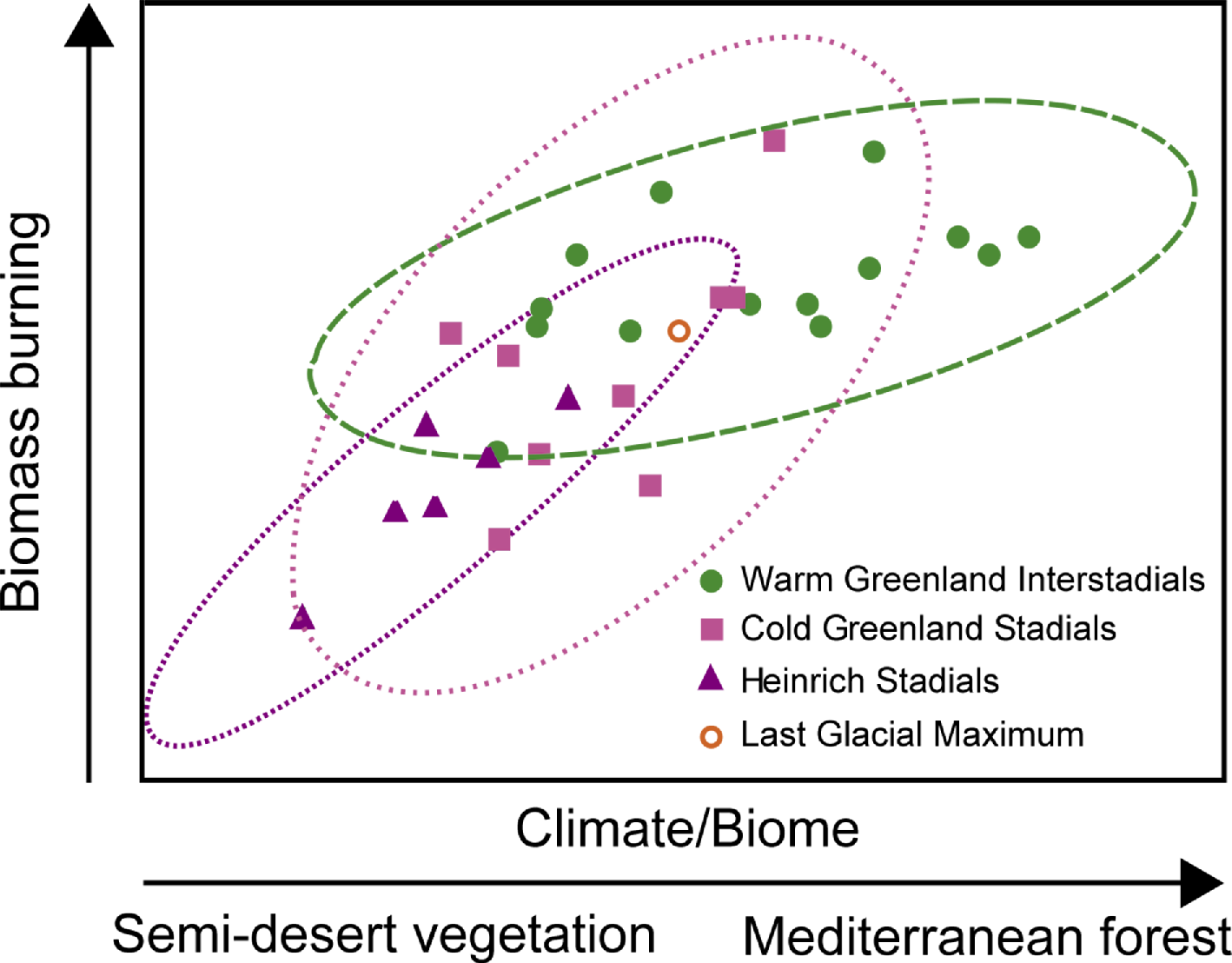
Figure 1: Fire-vegetation-climate interaction during abrupt climate change of the last glacial period in the Mediterranean region (modified from Daniau et al. 2010). During cold periods (Greenland and Heinrich Stadials), the dominant vegetation was characterized by semi-desert vegetation. The fuel-limited environment restricted biomass burning activity. The increase of regional temperature and humidity at the time of warm periods (Greenland Interstadial) led to a fire regime and vegetation shift towards increased biomass burning. |
In recent years, variations in past fire activity have been mainly described by compositing fire signals geographically over large areas with heterogeneous vegetation or even climate-driven vegetation shifts. In contrast to that, the key purpose of this workshop, titled “Fire history baselines by biome”, was to reconstruct fire activity based on vegetation patterns. We identified several approaches for such comparisons and discussed concepts based on regions with an underlying homogeneous vegetation (i.e. biomes; Fig. 1). These approaches range from testing fire vs. biome modeling to the study of fire traits, i.e. interactions between plants and fire that are explicitly described by a set of fire-specific plant functions. Ideas also emerged to investigate deviations from a “baseline” as past reference characteristics of a fire regime within a certain ecosystem (under stable-state conditions).
Model-data comparison based on the forthcoming FireMIP experiments offers another opportunity to better understand fire-vegetation interactions in the Earth system. In this regard, discussions focused on Last Glacial Maximum (LGM) to present comparisons, the experimental design, and on challenges in model-data comparison. The latter point related to the reduced number of sites for LGM to compare with and the interpretation of the time series within the Global Charcoal Database given as normalized trends. Such relative changes in past fire regimes limit the messages and possibilities that can be drawn out of these model-data comparisons.
Many of the discussions stressed the importance of calibration studies to obtain quantified and precise reconstructions of past fire regime metrics (fire size, intensity, frequency, etc.). GPWG2 launched a calibration initiative to build a “modern Global Charcoal Database”, which will provide the possibility to analyze fire activity based on absolute numbers and a uniform and consistent set of charcoal units. This will allow a better interpretation and detailed intercomparison of charcoal records. Furthermore, upcoming model-data studies based on quantifiable variations in fire activity (i.e. fire regime metrics) will be possible. During the meeting, the next steps of this calibration endeavor were addressed and preliminary results suggest that calibration is possible when field, laboratory and analysis methods are consistent.
General statements on the risk of fires and the change of fire-danger indices in the IPCC indicate that both seem to increase under global warming. However, these indices are built upon simple assumptions rather than on detailed model analysis using dynamical vegetation–fire models including the interaction of all feedbacks (like fuel productivity influenced by the atmospheric CO2 fertilization). To propose a better evaluation for the next IPCC report, the workshop participants designed an expert assessment survey on the likelihood of future fire regime change for different climate-change scenarios. This assessment will focus on different Representative Concentration Pathways climate scenarios and compile the expert knowledge of modelers, field researchers and paleo-fire experts about the most relevant factors influencing fire regime in a particular region at different timescales.
The workshop also fostered connections between GPWG2 and two INQUA International Focus Groups – ACER and FBI-HYD. The development of a chronologically harmonized dataset of pollen and charcoal for the last glacial period (ACER) will allow analyses of fire-vegetation interactions in response to abrupt climate change (Fig. 1), and the cooperation with FBI-HYD, which examines fire-hydrology linkages in southern Africa, will expand the possibility of integrating the hydrological balance into vegetation-fire modeling in subtropical regions.
acknowledgements
PAGES, PICS CNRS 06484 project, CNRS-INSU, Région Nouvelle-Aquitaine, University of Bordeaux DRI and INQUA are acknowledged for workshop support.
affiliations
1Environnements et Paléoenvironnements Océaniques et Continentaux, CNRS-University of Bordeaux, Pessac, France
2Helmholtz Centre for Ocean Research, GEOMAR, Kiel, Germany
contact
Anne-Laure Daniau: al.daniauepoc.u-bordeaux1.fr
reference
Daniau AL et al. (2010) PLoS ONE 5, doi: 10.1371/journal.pone.0009157
Heather D. Bervid1, A. Glueder1, E.A. Steponaitis2 and A.G. Yanchilina3
PALSEA2 workshop, Mt. Hood, USA, 19-21 September 2016
The PALeo constraints on SEA level rise 2 (PALSEA2) working group recently convened for its fourth meeting, hosted by Oregon State University, at Timberline Lodge on Mt. Hood. This meeting focused on constraining sea-level budgets at decadal to millennial timescales in an effort to connect modern-instrumental and paleo sea-level records. Presentations addressed recent findings in terrestrial and marine sediment records, ice-sheet and ocean models, data analysis, and methods of linking modern sea-level observations with the paleo record.
 |
|
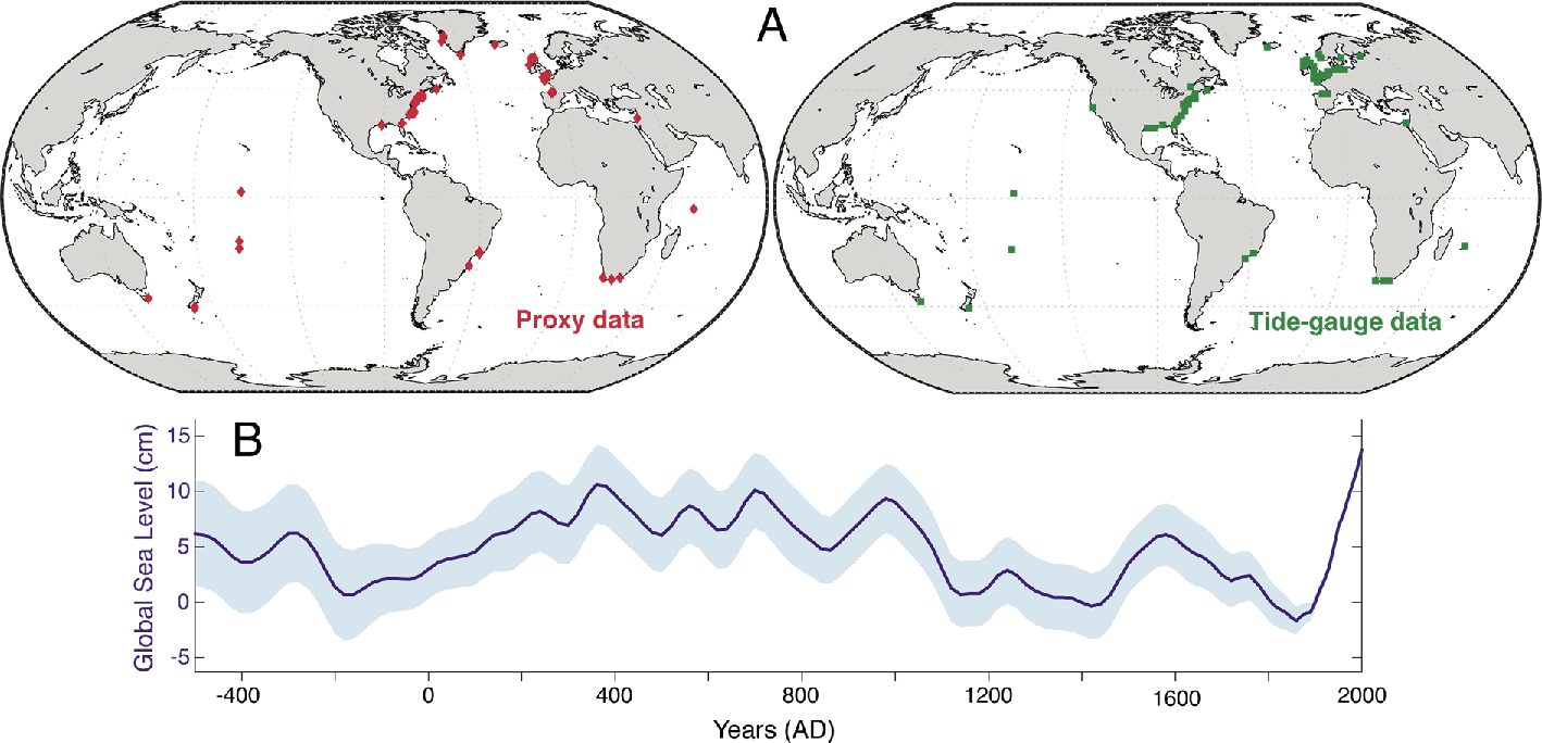
Figure 1: (A) Global distribution of paleoclimate proxy and modern tidal gauge sites, and (B) reconstruction of late Holocene sea-level changes (from Kopp et al. 2016; Copyright, 2016, National Academy of Sciences). Shading gives the 67% credible interval. |
Sea-level change since the Little Ice Age is preserved and widely studied in saltwater marshes. Saltwater marshes have potential to provide a biostratigraphic mechanism (using diatom assemblages) for linking past sea-level change data with instrumental observations to create a continuous record of Late Holocene sea-level change, and offer valuable near-, intermediate-, and far-field records of ice-sheet influence on sea level. However, the uncertainties associated with marsh records, including compaction and tidal range, must be taken into consideration when using these records to constrain ice-sheet sources. While existing global marsh records make up an extensive database of sea-level change (Fig. 1a), regions outside the northern Atlantic basin are understudied. This large data gap emphasizes the need for future field efforts in the Southern Hemisphere and the Pacific basin.
Uncertainties in current global sea-level records highlight the need to close the sea-level budget since the Last Glacial Maximum (LGM) and account for 4-32 m of missing ice and water (Fig. 1b). These uncertainties in the sea-level budget result from incomplete understanding of the system and are thus perpetuated by incomplete models of parameters such as ocean density, transient processes of ice sheets, global isostatic adjustment, dynamic topography and mantle rheology, groundwater and surface water systems, and land processes. Time periods in Earth history, including Marine Isotope Stage 3 (MIS 3), are also understudied, resulting in disagreement of sea-level reconstruction in the order of ~40 m between different records, and require more attention in the research community. Presentations on the complexity of this problem showed that the success of various global isostatic adjustments and earth models is largely dependent on choosing the right model for a specific research question to a specific region.
While datasets on Holocene paleoclimate and sea-level change are extensive, there is a need to compile these datasets into an open-access, intuitive database to spatially and temporally link these records at global and local levels. An ideal database would include all significant metadata, allowing researchers to improve upon dating techniques and standardize methods of data and statistical analysis. As it stands, there are significant uncertainties and inconsistencies between research groups in dating and modeling sea-level change, highlighting the need for incremental improvements of these methods within the paleoclimate community.
In the final discussion, there was a consensus that research on sea-level change could benefit significantly from collaboration with experts in other fields. Future work with Earth-system modelers, statisticians, and geophysicists who have an interest in paleoclimate studies, is necessary to address critical questions in glacial isostatic adjustment modeling, geochronology, database compilation, and data analysis. These collaborations would help better understand a system that has important implications for monitoring ongoing (and predict future) global sea-level change, and, ultimately, to make more robust predictions on the effect of climate change on local and global sea level. For the final phase of the working group, PALSEA2 will reconvene in 2017 with a focus on the phasing of sea-level and ice-sheet responses to climate change, and the processes and timescales which govern these responses.
acknowledgements
Funding was provided by PAGES, INQUA, Oregon State University and the University of Florida. Thanks to the local hosts – Anders Carlson, his research group, and the staff at Timberline Lodge for their efforts.
affiliations
1College of Earth, Ocean, and Atmospheric Sciences, Oregon State University, Corvallis, USA
2Department of Earth and Environmental Sciences, Tulane University, New Orleans, USA
3Department of Earth and Planetary Sciences, Weizmann Institute of Science, Rehovot, Israel
contact
Heather Bervid: bervidhoregonstate.edu
reference